
|
Geological Survey Bulletin 612
Guidebook of the Western United States: Part B |
ITINERARY
|
|
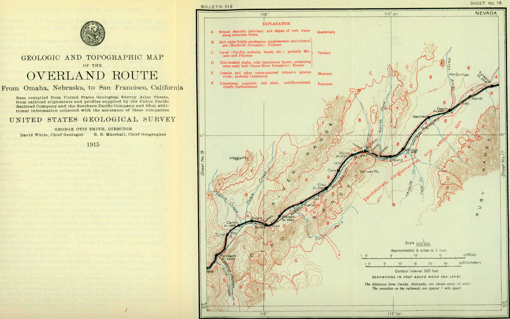
SHEET No. 18. (click on image for an enlargement in a new window) |
The Ruby Range is a typical Great Basin mountain ridge. It rises abruptly on all sides from flat valley plains or low, even slopes of rock detritus or "wash." The northern part of the range is granite, formerly considered Archean but now known to be of post-Jurassic, probably Cretaceous age. (See table on p. 2.) Flowing streams from the Ruby Range reach the railroad in places, and hay meadows and grainfields have been established wherever the water supply is sufficient to permit irrigation. Wild grasses are cut for hay along the flood plain in the main Humboldt Valley, and numerous haystacks are usually visible from the railroad. Beyond Nardi (see sheet 18, p. 168) a few ranches appear along the Humboldt, which is joined near Deeth by Marys River, from the north. It is said that 7,000 acres are irrigated in this vicinity, but on account of the scanty water supply only native grasses are grown, which are sometimes cut for hay and sometimes used for grazing in fall and winter.
The main settled areas in this general region are Starr and Ruby valleys, south of the railroad, at the foot of the Ruby Range. Starr Valley contains some 3,700 acres of irrigated lands, for which Herders, Starr, Ackler, Deering, and Boulder creeks furnish an ample water supply until about the middle of July each year. Nearly one-fourth of this valley is "self irrigating" through seepage from higher irrigated lands. These "self-irrigating'" lands are usually left in native grass, which is cut for hay or used for pasture.
|
Deeth. Elevation 5,341 feet. Population 200.* Omaha 1,193 miles. |
From Deeth, which is a trading center for Starr and Ruby valleys, a stage line runs north 52 miles to Charleston (Cornwall Basin), whence ore and concentrates (gold and copper) are shipped through this station. Jarbidge, a gold and silver mining camp in the extreme northern part of the State, formerly had its outlet through Deeth but now receives mail and supplies from Twin Falls, Idaho, by way of the Oregon Short Line.
West of Deeth the view of the Ruby Range broadens as the railroad bends southward along the west front of these mountains and at the same time gradually leaves them. The range from this viewpoint shows a high and rugged crest with approximate north-south trend, notched near the north end by a low pass. The highest summits lie north of the pass, among them Mount Bonpland, about 11,300 feet in elevation, and Clover Peak, just south of it, probably higher.
Natchez and Rasid are unimportant stations between Deeth and Halleck. The Humboldt appears as a meandering stream close at hand south of the railroad, bordered by narrow meadows of wild grass, behind which are low terraces or ridges. These terraces have evidently been formed by the river at an earlier period of its history and generally have a surface covering of gravel.
|
Halleck. Elevation 5,232 feet. Population 117.* Omaha 1,206 miles. Elburz. Elevation 5,204 feet. Omaha 1,209 miles. |
Halleck is a shipping point for cattle and sheep. The station received its name from old Camp Halleck, a fort and military reservation of pioneer days, close under the mountain front, about 12 miles away, just south of the pass near the north end of the range. Stage lines run from Halleck to several places on the north and south.
Elburz, a water tank, sidetrack, and section house, is just above the mouth of North Fork, the principal tributary of the Humboldt from the north. The land watered by the North Fork and its tributaries is divided into an upper and a lower valley by a range of mountains through which the stream flows midway in its course. About 4,500 acres of land is irrigated in the upper valley of the North Fork and 1,200 to 1,500 acres in the lower valley. Hay is the only crop raised.
Just below the North Fork the Humboldt Valley narrows to Osino Canyon. For a distance of about 50 miles, extending nearly to Beowawe, the strip of irrigable land along the river is rather narrow—in fact, in some places there is none. The meadow land is used for hay or pasture.
In Osino Canyon the railroad passes through three tunnels and crosses the river several times. The walls of the canyon consist of lava rock, which, although light colored when freshly broken, is weather-stained to dark or rusty tints.
West of Osino Canyon the valley is broader, and near Elko cultivated fields and ranches come into view. The valley here extends from the foothills of the Elko Range on the southeast to the low benchlike spurs of the River Range on the northwest. These spurs slope off gently toward the middle of the valley and are composed almost entirely of volcanic ash, generally of white color, containing fragments of lava. These beds belong to the Humboldt formation (Pliocene). Underneath them are steeply tilted strata which contain beds of impure coal and are supposed to be of Eocene age.
|
Elko. Elevation 5,061 feet. Population 1,677.* Omaha 1,226 miles. |
The origin of the name of Elko, the seat of Elko County, is not certain, for according to some it is an Indian word and according to others it was given on account of the abundance of elk in this vicinity. A camp site near some hot springs 1-1/2 miles west of the town made this place a station on the old emigrant route, but the present town originated with the building of the railroad in 1868. The older part of the town, through which the two railroads now pass, is built on the river flood plain, but a more recent extension of the residence portion may be seen on a terrace north of the river. The main industries of this locality are stock raising and ranching. A stage line runs from Elko to Tuscarora,1 a mining camp 50 miles to the north.
1Placer gold was found at Tuscarora in 1867 and rich silver veins were discovered several years later. In the seventies and eighties a number of silver mines were opened, and for several years a large production was maintained. Most of the ore was milled at Tuscarora, and only very high grade ore was shipped to smelters. The production of the district, chiefly in silver, is estimated to have been between $25,000,000 and $40,000,000, most of which was obtained between 1872 and 1886. In recent years most of the mines have been closed.
Other camps of this general region are Bullion and Lone Mountain. Bullion, where the mining of silver and copper ores began 40 years or more ago, became inactive when the price of silver fell, but in 1911 mining was resumed, and during the early part of 1914 ore was hauled by motor trucks to Palisade. Lone Mountain, 28 miles north of Elko, shipped in 1913-14 some ore yielding copper and silver.
Indians are usually seen about Elko, Lovelock, Reno, and at other stations along the route. Several Indian reservations lie wholly or partly in Nevada, and Indian schools are maintained at Carson and near Fallon. The Indian population of Nevada, about 5,000, consists of Piutes, Shoshones, and the remnants of other tribes.
For many years there has been much interest in the possibility of finding oil in some of the Tertiary shales a few miles south and east of Elko. Several wells have been drilled in this vicinity, but oil has not been found in commercial quantity. Some oil appears to be disseminated though these shales, but it is questionable whether they contain any oil pools. Similar shales in this country and abroad have been made to yield oil by distillation, and this industry might under favorable conditions be profitable here. Oil-bearing shales of Tertiary age occur in other parts of the country, as in the Book Cliffs of Colorado and Utah.
Sandstone from the Tertiary beds near Elko has been used as a building stone, and there is a granite quarry some 30 miles to the north.
A mile and a half west of Elko, south of the railroad and across the river channel, is a group of buildings, including a hotel and bath houses, that mark the position of the hot springs above mentioned. The main group of springs is well up on the lower slope, at the upper edge of a terrace near the foot of the steep mountain front. Others issue lower down, near the river channel. These springs are probably related to the zone of late faulting by which this mountain block has been uplifted. Waters derived from great depth may owe their heat to the higher temperatures generally found with increase in depth, to the fact that they have passed though or near some mass of intruded igneous rock, or to direct volcanic action. Faults along which there has been comparatively recent movement produce openings that allow such waters to reach the surface. Hot springs are found in many parts of the Great Basin.
West of Elko distinct river terraces show on the south side of the river. The Southern Pacific follows the upper edge of the meadow north of the river; the Western Pacific keeps closer to the stream.
Avenel (elevation 5,021 feet), Moleen (4,982 feet), Tonka (4,958 feet), and Vivian (4,918 feet) are sidings or unimportant stations. After passing Moleen (between mileposts 545 and 544) the train runs southwestward down the narrowing valley, passing close to cliffs of massive blue limestone. The railroad here is approximately parallel with the trend or strike of the beds. At the entrance to Moleen Canyon the track turns sharply to the northwest and within the next mile or two passes a most interesting exposure of Carboniferous limestones and quartzites. The limestone is about 2,000 feet thick, although not all the beds are exposed in continuous section. The quartzite underlying the limestone is in beds which stand nearly vertical. The river here makes a sharp bend to the north, rounds a ridge of the quartzite, and returns on an almost parallel course on the other side. The railroad passes through this ridge in a tunnel. Beneath the quartzite on the south side of the river lie slaty and heavy blue limestones, inclined 45° or 50° E., which extend along the south side of the valley as far west as Carlin. One of the shaly beds near the top of these lower limestone beds contains a little impure coal.
Beyond Tonka there is a tunnel and the Southern Pacific and Western Pacific tracks wind down the narrow canyon together. The valley again broadens as Carlin is approached.
|
Carlin. Elevation 4,898 feet. Population 423.* Omaha 1,248 miles. |
Just before reaching Carlin station the train passes an icing plant where the ice boxes of refrigerator cars are replenished in summer. Some of the ice thus used is cut near by, in vats in which river water is allowed to freeze in winter, and some is shipped from the Sierra Nevada. Carlin is a railroad division point with shops and engine houses. There are some ranches in the vicinity, and several mining camps along the east slope of the Cortez Range north of Humboldt River and west of Carlin. None of the mines, however, is extensively developed or has produced more than a few tons of ore.
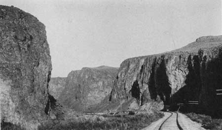
The valley below Carlin is narrow and is bordered on the south by rounded, indistinctly terraced hills, passing into a low rolling country to the north. Beyond Tyrol (a sidetrack, elevation 4,876 feet) the valley becomes still narrower, and rusty-brown ledges of lava appear on both sides. This is the upper end of Palisade Canyon (Pl. XXXV, p. 153), which within a short distance contracts until there is little room for more than the river and the railroads, hemmed in by the lava cliffs. Parts of the canyon wall show that the lava consists of a number of flows, indicating eruption at several distinct times.
|
| PLATE XXXV.—PALISADE CANYON, NEV. Humboldt River has here cut a narrow channel through the Tertiary lavas. Photograph furnished by Southern Pacific Co. |
|
Palisade. Elevation 4,844 feet. Population 242.* Omaha 1,257 miles. |
From the small town of Palisade the narrow-gage Eureka & Palisade Railroad runs to Eureka,1 one of the most famous of the old mining camps of Nevada, 80 miles to the south. The narrow-gage line goes up Pine Creek, the mouth of which is passed just beyond the tunnel at Palisade. Pine Creek valley trends due north, and irrigated lands lie along it for 30 to 35 miles.
1The first claims in the Eureka camp were located in 1864, but it was not until 1869 that the Eureka mine was developed on Ruby Hill. From that time until the early eighties this was the most active mining camp in Nevada and had a population of about 6,000. Between 1869 and 1883 the district yielded $60,000,000 in bullion, about one-third gold and two thirds silver, and about 225,000 short tons of lead. After 1878 the production declined. The lead ores constituted the main source of gold and silver until 1910, since when the greater part of the precious metals has been derived from milling ore containing little or no lead.
The Eureka district comprises a rough, almost completely isolated mountain mass, and it is doubtful if within the Great Basin province there can be found any region of equally restricted area surpassing it in its exposures of Paleozoic formations, especially those of the lower and middle Paleozoic systems. The sedimentary formations represent all ages from Lower Cambrian to Pennsylvanian (see table on p. 2) and have a total thickness of 30,000 feet.
In post-Jurassic time the strata in this district, as elsewhere in Nevada, were crumpled into a series of folds, some of them with very steep sides. The folding was followed by intense faulting. The more profound faults had a general northerly trend, and there were branches or connecting faults of northwesterly trend. Next came a long period of erosion. Tertiary time was marked by great volcanic activity, lavas (andesite, rhyolite, and basalt) breaking up to the surface along certain of the larger faults.
The Ruby Hill ore deposits were found in a roughly V-shaped mass of shattered limestone between the main Ruby Hill fault and a branch fault which for the most part followed the contact of the limestone with quartzite. The shapes of some of the ore bodies suggest that they were formed by replacement along fractures, but as a whole they are very irregular. The minerals originally deposited in the limestone were pyrite, arsenopyrite, galena, and zinc blende, with minor amounts of molybdenite and other minerals, but the bulk of the ore mined was oxidized nearly down to ground-water level, which ranged from 600 to 1,100 feet below the surface. One of the principal kinds of ore, known as "red carbonate," was composed of a hydrous iron oxide mixed with sulphate and carbonate of lead and inclosing residual lumps of galena. Most of it carried gold and silver to the amount of $25 to $50 of each to the ton. In some of the ore, however, the gold was worth much more than the silver.
Several of the ore bodies in Prospect Mountain contained a large amount of quartz and a relatively larger proportion of gold to silver, with less lead. Some contained bismuth and tellurium.
According to J. S. Curtis, who studied the deposits in 1881 and 1882, the ores were deposited by hot volcanic waters which ascended along the fissures after the rhyolite eruptions. Curtis assumed that these waters had leached the metals from some deep-seated rock.
Below Palisade the route continues down the canyon, which is wider and bounded by less steep walls than east of this town. The lavas, which all look much alike in general aspect, are chiefly basalt and andesite. Not far beyond Palisade the Southern Pacific and Western Pacific tracks cross, but both lines still follow Humboldt River closely.
| <<< Previous | <<< Contents >>> | Next >>> |
bul/612/sec27.htm
Last Updated: 28-Mar-2006