
|
Geological Survey Bulletin 614
Guidebook of the Western United States: Part D. The Shasta Route and Coast Line |
ITINERARY
COAST LINE.1
1A large part of the material relating to the route between Los Angeles and Watsonville Junction has been furnished by Mr. Ralph Arnold.
|
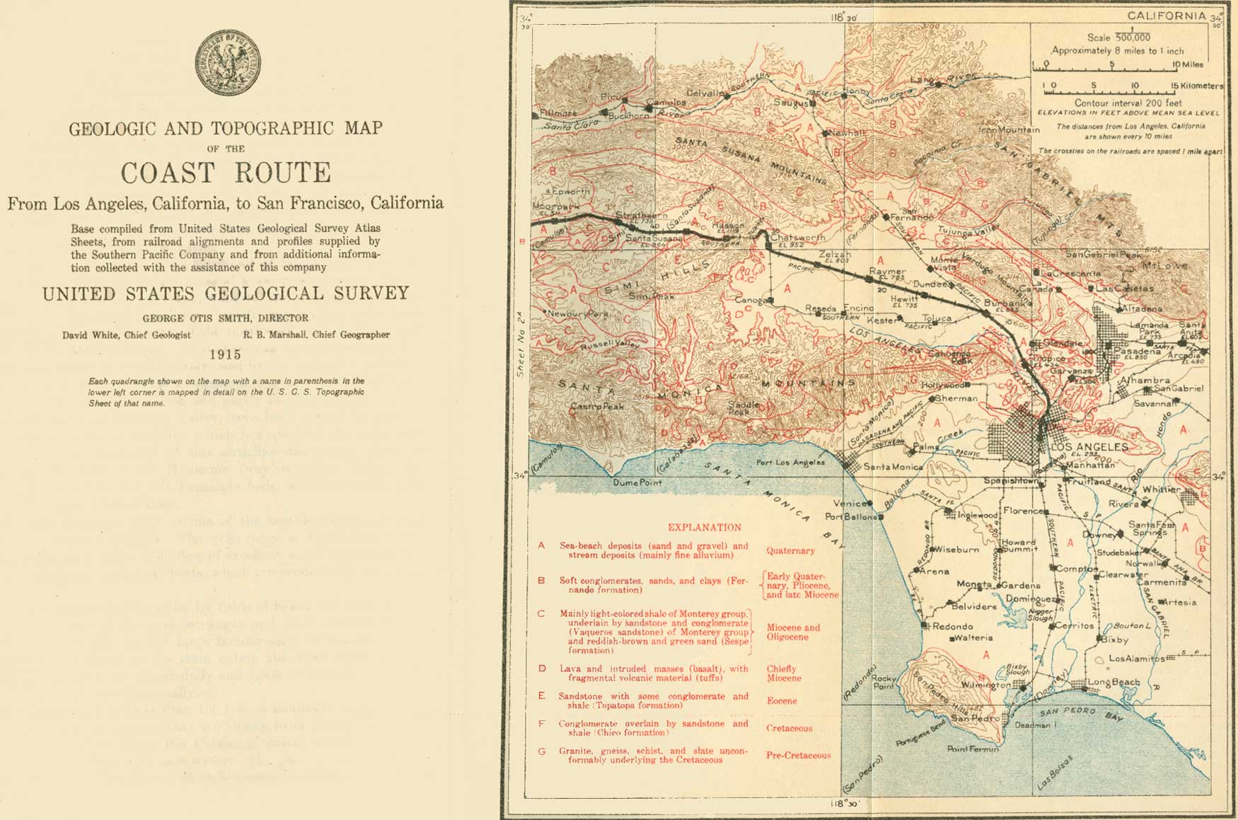
| SHEET No. 1A (click on image for an enlargement in a new window) |
LOS ANGELES TO SAN FRANCISCO.
|
Los Angeles. Elevation 293 feet. Population 319,198. |
Los Angeles (Spanish pronunciation, loce ahn'hay-lace) is the metropolis of the Southwest and is preeminently a city of homes. It lies on Los Angeles River (see sheet 1A, p. 102) only 15 miles from the sea and is built on a series of broad steplike terraces which, although now from 250 to 500 feet above sea level, were probably in part carved by the waves of the ocean. The situation of these terraces and their equable climate (mean temperature, January 54°, August 72°) have made Los Angeles and its sister city, Pasadena, two of the most attractive home cities in the world.
The Pueblo de Nuestra Señora la Reina de los Ángeles (city of Our Lady the Queen of the Angels) was founded by the Spaniards in 1781, and the Plaza Church marks the site of the old village. It became an American possession in 1846 but attracted little attention until the transcontinental railways were built. In 1885, although a century old, Los Angeles was still a town of adobe houses with but few more than 11,000 people. The opening of this delightful region brought floods of settlers. In 1900 it had a population of 102,479, and in 1910 this had more than trebled. A city census taken in June, 1915, indicated a population of 528,000. The residential portion of the city is noted for its many beautiful mansions embowered in semitropical bloom and verdure. The rapidly growing eucalyptus, from Australia, and the graceful pepper tree, from Peru, with palms, native and foreign, are the most abundant trees in the streets and parks. Although largely residential, the city has over 2,300 factories, whose output in 1913 was valued at more than $157,000,000.
The water supply is excellent and is brought by an aqueduct from Owens Valley, 226 miles away. For the building of this aqueduct across the desert and through the mountains $23,000,000 in bonds were issued.
Los Angeles is in the heart of the fruit-growing region of southern California. The surrounding plains and valleys are covered with vineyards and orchards—olives, oranges, and lemons. The shipment of citrus fruit from the region in the season of 1913-14 amounted to 40,000 carloads.
In Los Angeles and vicinity there are about 50 moving-picture studios, representing an investment of several million dollars. This region is said to be the center of the world's film-producing industry.
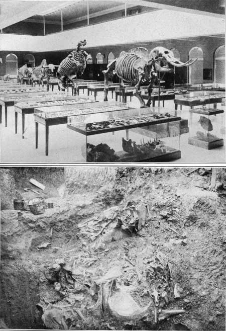
The Museum of History, Science, and Art is one of the most interesting places in the city. It has fine collections in many branches, exhibited in an attractive and instructive manner. The museum authorities control the wonderful bone deposits (Pl. XXV, B) in the asphalt springs of Rancho La Brea, about 8 miles directly west of the city. These springs have been for centuries the most effective natural animal trap known, and the asphalt has preserved the bones of the thousands of animals caught in its deceptive and sticky pools. The skeletons of elephants, camels, sloths, saber-toothed tigers, bears, and myriads of smaller animals, including many birds, are being gradually dug out and set up in the museum (Pl. XXV, A). Among the bones has recently been found, the skull of a human being who lived probably not less than 10,000 years ago, contemporaneously with many animals now extinct.
|
|
PLATE XXV.—A. LA BREA WING OF THE MUSEUM OF
HISTORY, SCIENCE, AND ART AT LOS ANGELES, CAL. The restored forms, in order from front to rear, are the mastodon (Mammut americanum), giant ground sloth (Mylodon), ancient ox or bison (Bossant quas), male and female, and saber-toothed tiger (Smilodon californicus). In the case in front of the mastodon is the only human skull yet found in the deposits. B. FOSSIL BONES IN ASPHALT DEPOSIT OF RANCHO LA BREA, NEAR LOS ANGELES, CAL. |
In the northern part of the city is a belt of oil-producing territory 5-1/2 miles long, covering an area of 2 square miles. Here hundreds of derricks have been erected in close proximity to dwellings.1
1The following notes are based on a concise account of the geology and technology of the California oil fields by Ralph Arnold and V. R. Garfias.
The production of petroleum in California is the most important mineral industry in the State, the annual value of the oil output equaling that of all the metals. Since 1903, with the exception of 1907 and 1908, California has annually produced more petroleum than any other State in the Union, and in 1914 the production was over 100,000,000 barrels.
The most productive fields are in the southern part of the great San Joaquin Valley, which lies in the central part of the State, and in the region along the coast from the vicinity of Los Angeles to a point a little north of Santa Barbara County (fig. 13).

FIGURE 13.—Map showing the oil fields of California. Oil is found in commercial quantity in geologic formations ranging in age from Cretaceous to Quaternary. The principal formations are shown in the table on page 94, the oldest at the bottom, the youngest at the top. All these formations are not present in any one region, and the thicknesses given are rough estimates.
Geologic formations in the oil fields of the coastal region of southern California.
Era. System or
period.Series or
epoch.Group or formation. Approximate
thickness,
in feet.Quantity of oil and
quality (Baumé).Cenozoic. Quaternary. Recent. Alluvium, terrace deposits. 1,000 Pleistocene. Fernando
formation.Paso Robles
formation.1,000 Large deposits of oil: 11°-19°. Also asphaltum. Tertiary. Pliocene. Pismo and Santa
Margarita formations.7,000
2,000Miocene. Unconformity Monterey group, including
Vaqueros sandstone.10,000 Oil; 12°-35°. Oligocene. Sespe formation. 4,300 Good oil; 26°-36°. Also some heavier oil. Eocene. Tejon formation. Topatopa
formation.5,000 Some high-grade oil; lower oil horizon. Martinez formation. 4,000 Unconformity Mesozoic. Cretaceous. Upper Cretaceous. Chico formation. 4,000 Unconformity Lower Cretaceous
or Shasta.Knoxville formation. 3,000± Unconformity Jurassic? Franciscan group. 1,000± Unconformity Paleozoic. Schist and limestone intruded by granite. ? In southern California the oldest formation containing oil in commercial quantities is the Topatopa (Eocene), from which wells in Simi Valley and at a few places in the Santa Clara River valley obtain oil. The oil so far produced from this formation is small in amount but it is very light and brings a higher price than any other oil in California.
The shale of the upper part of the Monterey group (Miocene) is the principal source of oil in California and has yielded oil in the Santa Maria, Santa Clara, and Puente Hills districts. The gravity of the oil ranges from 120° to 35° Baumé. This shale is made up largely of the remains of diatoms—minute aquatic plants composed of a jelly-like substance surrounded by a shell of silica. Only the hard shells are now visible. They may be seen with a strong magnifying glass in the earthy varieties of this shale, the more common forms appearing as flat disks which look like minute percussion caps. The soft matter is believed to have been changed into petroleum. Besides the diatoms the shale contains the shells of minute animal forms called foraminifers, the soft matter from which probably also formed part of the petroleum. The oil formed from these animals and plants has moved into the sandy beds interstratified with the shale, where it fills the spaces between the sand grains; or into the cracks and joint planes in the hard and flinty shale itself.
The Fernando and its equivalent post Monterey formations contain the most important oil reservoirs in the State, owing in great measure to their unconformable position upon the underlying Monterey group, which has facilitated the upward migration of the oil originating in the Monterey. In general the Fernando sediments consist of more or less incoherent conglomerates and sands, clayey shales, and soft clays. With some exceptions the oil produced by the Fe nando is of the fuel type, its gravity ranging from 11° to 19° Baumé. Large deposits of asphaltum, the residuum from oil escaping into the Fernando from the Monterey group, occur at a number of places.
The oil in the California fields, as in most others throughout the world, occurs in inclined or sloping beds of porous sand, and these oil sands are usually overlain and underlain by water sands, which are separated from the oil sands by impervious clay, shale, or other strata.
The principal oil fields adjacent to Los Angeles are those of the Los Angeles district and the Puente Hills district. The Los Angeles district includes the City field, lying in the city of Los Angeles, and the Salt Lake field, immediately west of the city limits, about 4-1/2 miles from its business center.
The City field was discovered in 1892, when a 155-foot shaft was sunk near a small deposit of brea on Colton Street. The first successful well was drilled later in that year on Second Street, and by the end of 1895 there were more than 300 wells, This field forms a narrow belt about 5-1/2 miles long running through the northern part of the city; the total area is about 2 square miles. The wells are from 500 to 1,200 feet in depth, and the gravity of the oil ranges from 12° to 19° Baumé. The limits of the field are well defined. The wells have always been small producers, necessitating pumping, and owing to the great number of wells drilled within a small area the field has been drained at a rapid rate and water has been allowed to enter the oil sands in many areas.
The first well in the Salt Lake field was drilled in 1901 by the Salt Lake Oil Co., and since 1902 this field has been the chief producer in the Los Angeles district. The wells are deeper than in the City field, ranging between 1,200 and 3,000 feet, and the average gravity of oil is between 16° and 18° Baumé. Considerable gas under strong pressure accompanies the oil, which causes the wells to gush during the early part of their life.
The oil in the Los Angeles district is derived largely from the upper 500 feet of the Monterey group and the basal beds of the Fernando formation. During 1914 the district produced about 2,500,000 barrels of oil, and between 1894 and the end of 1914 it produced over 40,000,000 barrels. At present there are about 700 producing wells in the district. The average daily production for each well in the City field is about 2-1/2 barrels and in the Salt Lake field about 23 barrels.
The oils of the City field are uniform in quality, although they vary considerably in gravity. They contain considerable sulphur, and owing to the entire absence of light products are of little value for refining, being used almost entirely for fuel. The oils produced in the Salt Lake field show a marked similarity in general properties, being characterized by a high percentage of sulphur. The heavy oils are highly viscous and yield considerable asphalt.
The Puente Hills district, from 12 to 34 miles southeast of Los Angeles, was the second oil district discovered in California. The first producing well in it was completed in 1880. Until 1893 the Puente Hills and Santa Clara River Valley districts yielded practically all the oil produced in California. The average depth of the wells in the Puente Hills district is somewhat more than 1,300 feet and the average life of the wells is about 16 years. The gravity of the oil varies between 21° and 32° Baumé.
The lighter grades of oil are believed to come from the Monterey group; the heavier grades are derived largely from the coarser sediments of the Fernando.
On December 31, 1912, there were 470 producing wells in the Puente Hills district, and the output for the year was nearly 7,000,000 barrels. The total production of the field from 1889 to 1912, inclusive, was nearly 41,000,000 barrels. The oil produced varies in composition, the greater part being of light grade and utilized by refineries near Los Angeles.
| Excursions from Los Angeles. |
With the permission of the Museum of History, Science, and Art the Rancho La Brea may be visited. On the way thither the traveler passes over a portion of the great alluvial plain of Los Angeles which underlain, least in part, is at by three Quaternary formations, the oldest of which is a marine deposit laid down horizontally on the beveled edges of a very thick series of tilted Pliocne beds. This marine Quaternary deposit has a thickness of 100 feet in the northwestern part of the city but thins to an edge near the ancient sea cliff beyond. Los Angeles River excavated a valley about a mile wide and 100 feet deep in the marine deposit and filled the trench with river deposits, the second Quaternary formation. This in turn is covered by the alluvium of the present plain.
Other excursions may be made to the coast at Long Beach (south, 21 miles), Santa Monica (west, 17 miles), Redondo (southwest, 23 miles), and San Pedro (south, 22 miles). San Pedro is the chief harbor of Los Angeles and is being greatly improved by the Federal Government. San Pedro Mountain, northwest of the town, has a core of older igneous rocks encircled by Tertiary beds. The slope of the hill is scored by a series of horizontal terraces suggestive of great steps. These were cut by the ocean waves when the land stood at lower levels. Deadman Island, near San Pedro, is one of the best localities on the Pacific coast to collect Pliocene and Pleistocene fossils.
From San Pedro steamers ply to Santa Catalina,1 a mountainous island composed chiefly of Franciscan (Jurassic ?) rocks. The sea fishing here is famous, and through the crystal-clear water the sea bottom and the plants and animals that inhabit it may be seen from glass-bottomed boats.
1The topography of Santa Catalina Island presents a striking contrast to that of the neighboring mainland and to that of San Clemente Island, which lies farther out in the ocean. The mainland and San Clemente Island show old beach lines and sea terraces standing high above the present shore and have therefore risen, but Santa Catalina Island shows no such markings; on the contrary, as Prof. A. C. Lawson has pointed out, this island presents unmistakable evidence of having subsided.
About 9 miles east of Los Angeles is San Gabriel Mission, founded in 1771, and near by is the interesting church erected in 1804 of material brought from Spain. Pasadena is easily reached by train or electric car. Trips likely to prove more interesting to lovers of nature or science are those to Mount Lowe and Mount Wilson. These summits belong to the San Gabriel Mountains, which present an abrupt face on the north side of the San Gabriel Valley. They are composed of granitic and other crystalline rocks which contain gold and other precious metals.
Mount Lowe (5,650 feet above sea level) is reached by the Pacific Electric Railroad from Los Angeles to Echo Canyon. From the canyon a cable railway runs over a l ,000-foot ascent to the summit of Echo Mountain (4,015 feet), where connection is made with a mountain railway for Alpine Tavern (5,000 feet). A trail leads from the tavern to the summit, from which a fine view may be obtained. The mountain mass is composed chiefly of granitic rocks, which by their disintegration have furnished much sedimentary material for the Tertiary deposits of the foothills and adjacent lowlands.
Mount Wilson (5,750 feet) may be ascended afoot or on burros from Sierra Madre (mah'dray), a station on the electric tramway. At the top is the solar observatory of the Carnegie Institution. The view is extensive and very beautiful. The rocks, like those of Mount Lowe, are highly crystalline. Hotels on the summit and northern slope make it possible to remain overnight on the mountain.
The great Los Angeles plain, on which the main part of the city of Los Angeles is built, has been trenched by the streams that cross it in a succession of steps or terraces. As the train leaves the Arcade Station the principal river terrace can be seen on the left by looking up some of the streets, particularly Main Street just below the Plaza.
Passing northward and eastward from the business portion of the city the train goes through the Southern Pacific Railroad yards, across which, to the left, can be seen the tops of the derricks at the east end of the City oil field. The oil wells were drilled close together in the residence portion of the city and, although many of the derricks have been removed, enough are left to attract attention.
North of the railroad yards the main line runs along Los Angeles River for half a mile. The river here cuts across the beds on the south flank of the main arch or anticline of the City oil field and exposes a fine section of the Miocene sandstone (Monterey) along its west bank. The beds dip south at angles ranging from 20° to 50°. About 472 miles from San Francisco the line crosses Los Angeles River opposite Elysian Park (on the hill to the left). The railroad continues up the east bank past fine orchards and berry farms. The hills to the right (east) are composed largely of the Miocene sandstone, folded into one or more well-developed anticlines. Farther north and east shales of Miocene (Monterey) age overlie these sandstones and form the rolling hills between Los Angeles and Pasadena.
|
Tropico. Elevation 434 feet. Los Angeles 6 miles. |
The prominent peak to the left (west) of the railroad, opposite Tropico, is Cahuenga (ca-wain'ga) Peak (elevation l,825 feet), of the Santa Monica Range. It consists largely of granitic rocks, but north of the peak a thick coarse conglomerate lies against the granite. South of the peak are flows and dikes of dark lava (basalt) and sandstones and shales of the Monterey group.
It is believed that south of Cahuenga Peak there is a strong fissure which the rocks on the south side have sunk or those on the north side risen. This fault probably extends westward along the of the Santa Monica Range, of which Cahuenga Peak is the easternmost point. The central mass of the range consists largely of of gneiss and black schist. Cretaceous and Tertiary rocks flank this crystalline core farther west, in the region north of Santa Monica.
|
West Glendale. Los Angeles 8 miles. |
Between Tropico and West Glendale the San Gabriel Range, rising from 2,000 to 3,000 feet above the valley, may be seen on the right (north). This range consists entirely of granitic and gneissoid rocks. Structurally it is a great block that has been lifted up along a well-defined fault which extends along the south base of the range from the region of West Glendale to the vicinity of Eagle Rock, just west of Pasadena. Eagle Rock, at the east end of the Eagle Rock Valley, which can be seen from the railroad in the vicinity of West Glendale, is an old landmark composed of a locally hardened mass of Miocene (Monterey) conglomerate. The "eagle" on the side of the rock is caused by shadows cast by overhanging portions of the conglomerate. The fault is very pronounced in the vicinity of Eagle Rock, where in con sequence of it the conglomerate beds on the south dip steeply toward the granitic mass on the north, although of course they are cut off at the fault and do not go under the granite.
|
Burbank. Elevation 555 feet. Los Angeles 12 miles. |
At Burbank the Coast Line turns off westward from the Valley Line and enters San Fernando Valley, noted for its large production of hay and fruit. South of Burbank, in the little valley at the northeast foot of Cahuenga Peak, on the edge of San Fernando Valley, is Universal City, the only city in the world built solely for the production of moving-picture film. This magic place can be changed in a few days to get any scene or setting desired—Athens, Rome, London, Paris, New York, Hindu streets, Afghan villages, all with true local color. Ten miles of film can be made here in a week. The city contains 3,000 or 4,000 persons, employees of the picture company, and a zoo comprising several hundred wild animals.
The Monterey beds on the north flank of the Santa Monica Range, south of the railroad, are intruded by basalt dikes and associated with flows of the same lava. Overlying the Monterey, and deposited later than the basalt flows, is the Fernando formation, consisting of conglomerates, sandstones, and soft shales, which dip toward the valley. The Fernando beds also flank the eastern extremity of the San Fernando Hills north of the San Fernando Valley. This formation is full of fossil shells and other marine organisms, which indicate upper Miocene, Pliocene, and Pleistocene age.
About 3 miles west of Burbank the railroad crosses Tujunga (too-hoon'ga) Wash, which marks the underground channel of a tributary to Los Angeles River. This phenomenon of underflow is characteristic of the arid and semiarid regions of the Southwest. Several mountain streams unite in forming Tujunga River, which debouches from the month of a canyon into Tujunga Wash. The water immediately sinks out of sight and flows through coarse gravels and sands under the plain until it reaches the hard rocks north of Cahuenga Peak, where it rises in springs and enters Los Angeles River, a perennial stream which supplied the city of Los Angeles with water until the Owens River supply became available. Many legal contests have arisen over the efforts of the people owning the land along Tujunga Wash to sink wells into the subterranean river, but the courts have held that the right of the city of Los Angeles to this water is as well founded as if the river flowed on top of the ground. Very little water flows over Tujunga Wash except during certain parts of the rainy season. Passengers often wonder why the railroad builds long trestles across apparently dry, cactus-covered desert, but during the torrential rains which occur every few years the wash becomes a raging torrent. Settlers who are not familiar with the characteristics of such washes are often robbed of their entire land holdings by changes of channel.
At milepost 457 the railroad crosses the pipe line from Owens River.
The traveler looking eastward from San Fernando Valley obtains a good view of the west end of the San Gabriel Range, which extends from the low Fernando Pass, utilized by the Valley Line of the Southern Pacific, eastward to Cajon Pass, north of San Bernardino, a distance of 70 miles. The culminating peak in the eastern portion of the range is Old Baldy, 10,080 feet in elevation. This peak, often snowcapped, is visible from Los Angeles. The western end of the range, including Mount Wilson and Mount Lowe, is lower, rising only to a general elevation of 3,000 to 4,000 feet. Some sedimentary beds of the Fernando formation flank the granitic rocks at the west end of the range and are faulted into contact with these rocks on the south. On a clear day the sedimentary rocks can be easily distinguished from the granites by their yellow color.
|
Raymer. Elevation 783 feet. Los Angeles 21 miles. |
At milepost 455 the Pacific Electric Railway track is crossed. On the left in the distance from Raymer station is the large white schoolhouse at Van Nuys, a town on a branch line of the Southern Pacific that runs through an agricultural district south of the Coast Line and nearer the river.
|
Zelzah. Elevation 803 feet. Los Angeles 25 miles. |
Zelzah is the great hay center of the San Fernando Valley. The region yields about 40,000 tons annually, of which 95 per cent is barley hay. Much fruit is also raised in the valley, the orchards being irrigated by pumping ground water. As the road approaches the west end of the San Fernando Valley the most prominent elevation to the left is Saddle Peak, the name being suggested by the obvious similarity of the mountain top to a saddle. The rocks here are very resistant sandstones and the crest of the ridge is rugged and almost inaccessible. The Santa Susana Range bounds the north side of this part of the valley
|
Chatsworth. Elevation 952 feet. Population 299.* Los Angeles 29 miles. |
To a geologist one of the most impressive sights of the whole trip from Los Angeles to San Francisco is the great escarpment of thick-bedded Eocene sandstones which blocks the west end of the San Fernando Valley. From the east the beds are seen to lie one on top of another to a height of nearly 1,200 feet above the valley. The continuation of these beds, whose edges are thus visible, lies under the San Fernando Valley, and the escarpment indicates a great break in the earth's crust along which the rocks on the north west side have been heaved up or those on the southeast side have sunk. In other words, the steep slope that closes the west end of the valley is a fault scarp. The faulting took place many hundreds of years ago and the cliff has, of course, since been modified by the action of water and air. This great fault extends from the southwest corner of the valley in a north-northeasterly direction into the Santa Susana Mountains. The Eocene sandstones are eroded into grotesque shapes, some of them suggestive of battlements rising steeply above the railroad.
Sandstone from the Topatopa formation (Eocene) quarried 2 miles northwest of Chatsworth is utilized for the San Pedro Breakwater and also as a building stone.
After passing through two tunnels which penetrate minor ridges the railroad goes through a tunnel, 7,369 feet long, about 500 feet below the Santa Susana Pass. The line between Los Angeles and Ventura counties is crossed midway of this tunnel. The Eocene beds (Topatopa) dip west at a rather low angle, so that the tunnel, from east to west, cuts successively younger or higher beds in the formation. Soon after leaving the tunnel, the train goes through some cuts of coarse Eocene conglomerate which overlies the beds just described. These rocks form the east end of Simi (see'me) Valley, which comes into view as the train proceeds westward beyond the tunnel.
|
Santa Susana. Elevation 964 feet. Los Angeles 37 miles. |
Although the Eocene series here is more than 3,000 feet thick, the dip of the beds to the west soon carries them out of sight under the younger formations. The rocks immediately overlying the coarse Eocene sandstone and conglomerate are soft rusty-brown sandstones of Oligocene age—the Sespe formation. On the north (right) side of the valley, opposite milepost 436, oil derricks of the Newhall field are seen in the distance near the base of some low hills lying in front of the main Santa Susana Range. These derricks mark the position of wells that penetrate the uppermost beds of the Eocene (Topatopa formation), on the flanks of a well-developed arch or anticline in these beds. The anticline extends eastward along the base of the hills. The wells range in depth from 300 to 1,800 feet and yield from 5 to 200 barrels each daily of 37° Baumé oil, the best oil in the State.
The light-colored beds showing low in the hills behind the derricks belong to the Sespe formation (Oligocene). Above them are darker beds belonging to the Vaqueros sandstone (lower Miocene). The very lightest beds at the top are the Monterey shale (Miocene). A full sequence of the formations is found in some of the canyons running northward from the Simi Valley to the crest of the range.
The hills immediately south of the town of Santa Susana consist of the rusty beds of the Sespe (Oligocene) formation. Farther back are the underlying Topatopa (Eocene) beds. Still farther south the Santa Monica Range consists of a thick series of Cretaceous sedimentary rocks cut by complicated masses of igneous rocks, largely of Miocene age.
The Simi Valley, like the San Fernando Valley, owes its existence and general form to the folding and faulting of the rocks—that is, it is essentially a structural valley and not wholly or chiefly the work of erosion. It is filled with alluvium to an unknown depth. On the north side of the valley a well-defined sag in the strata (a syncline) underlies the line of hills between the crest of the nearest range and the crest of the most northern range visible. This northern range forms the south side of Santa Clara Valley1 from Saugus to Ventura. On both sides of that valley are productive oil fields that yield petroleum ranging from a heavy, tarry oil to an oil of very light gravity that is much sought after by the refiners of illuminating oil.2
1There are at least two Santa Clara valleys in California—one in Ventura and Los Angeles counties, drained by Santa Clara River, and the well-known fertile lowland just south of San Francisco Bay, in Santa Clara County. The traveler from Los Angeles to San Francisco passes through parts of both of these valleys and should keep the distinction in mind.
2The Santa Clara district is the oldest oil-producing territory in the State, the first oil being obtained here about 48 years ago from tunnels driven near Ventura and on the south flank of Sulphur Mountain. The first productive well in California was drilled near Ventura in 1867. The district includes the region on both sides of Santa Clara River from the Newhall field, in Los Angeles County, 40 niiles northwest of Los Angeles, to the Ojai Valley field, in Ventura County, about 50 miles farther west. The Santa Clara district produced practically all the oil in the State up to 1880, when the Puente Hills district was discovered. The bulk of the production is of refining grade. The yield in 1913 was 1,042,348 barrels, most of which was piped to seaboard.
The district comprises 13 fields, some of which are in almost inaccessible places, the productive territory being confined to very narrow strips along the crests of sharp folds. The wells range in depth from 200 to 3,700 feet, a large number being less than 1,000 feet deep. It is estimated that the average depth of the wells is less than in any other district in the State.
The heaviest oil, ranging from 11° to 16° Baumé is found in the Ojai Valley, Hopper Canyon, and Elsmere Canyon fields. Practically all the other fields yield refining oil ranging from 23° to 38° Baumé. The wells vary greatly in capacity, some having an initial flow of 500 to 600 barrels a day and some being profitably operated for a yield of 2 barrels a day or even less. It is estimated that the average daily production per well for the entire district in 1913 was 7.2 barrels.
Although practically all the fields have been operated for many years, the territory is by no means all prospected, and additions to the productive areas are being made from time to time.
The formations involved in the geology of the district include a basal complex of granitic and gneissic rocks, on which rest the Topatopa, Sespe, Vaqueros, Monterey (upper part), and Fernando sedimentary formations. All these sedimentary formations contain oil, but the Sespe is the most productive.
The production of the Santa Clara district in 1870 was 3,600 barrels. The production in 1913 was 1,042,348 barrels, and the total production of the district, including that of 1913, has been 16,139,943 barrels.
|
Simi. Population 748.* Los Angeles 42 miles. |
A stratigraphic arch, the Simi anticline, crosses the mouth of Tapo Canyon from east to west, extends westward for 2 or 3 miles, and then gradually swings toward the southwest, crossing the west end of the Simi Valley. The hills which limit this valley on the west have been carved by erosion from the upfolded beds of this anticline, The beds on the north flank of the anticline are well exposed in the hills northwest of the valley.
From the town of Simi the railroad follows Arroyo Simi to Moorpark. The rocks exposed in the cuts along the arroyo (Spanish for small stream) are chiefly conglomerates and sandstones of the Sespe (Oligocene) formation. The same rocks also compose the low hills on both sides of the track as far as one can see.
|
Moorpark. Elevation 511 feet. Los Angeles 48 miles. |
An old terrace is visible on the north side of the track at the head of the Little Simi Valley, north of the village of Moorpark. This terrace was probably formed at the same time as some of the marine terraces on the coast, though it is doubtless due to stream erosion and not to waves. Moorpark is a center for barley, hay, dried fruit, and beans. Water for irrigation is pumped from Little Simi Creek. West of Moorpark the rocks of the Fernando formation form low hills on both sides of Little Simi Valley. The high hills farthest north, including Oak Ridge, consist of the Vaqueros and higher beds of the Monterey group, which here have an anticinal structure. Remnants of the old river terrace appear along the south side of Little Simi Valley for 2 or 3 miles below Moorpark, and near the west end of the valley suggestions of other less prominent terraces are seen on both sides. Little Simi Valley owes its form partly to structure but largely to erosion.
From Ternez and Lagol, in the western part of the Little Simi Valley, fine distant views may be had to the right (north) of San Cayetano Mountain (4,122 feet), which lies beyond Oak Ridge and Santa Clara River, just west of Sespe Canyon. The mountain consists largely of Eocene (Topatopa) and overlying Oligocene (Sespe) beds. Its southern slope is a fault scarp modified by erosion.
North and west of San Cayetano Mountain are visible the Topatopa Mountains, a prominent range in the Santa Barbara National Forest. This range is the eastern extension of the Santa Barbara and Santa Ynez Range, along the south base of which the railroad runs from Ventura to Point Conception, a distance of nearly 75 miles. Its structure in general is anticlinal, the crest of the arch being pushed over (overturned) to the south. It consists principally of Topatopa (Eocene) and Sespe (Oligocene) rocks, flanked along the lower hills by sandstones and shales of the Vaqueros and later beds of the Monterey group (Miocene).
| <<< Previous | <<< Contents >>> | Next >>> |
bul/614/sec1a.htm
Last Updated: 8-Jan-2007