
|
Geological Survey Bulletin 707
Guidebook of the Western United States: Part E. The Denver & Rio Grande Western Route |
MAIN LINE OF RAILROAD FROM GRAND JUNCTION TO SALT LAKE CITY.
(continued)
|
|
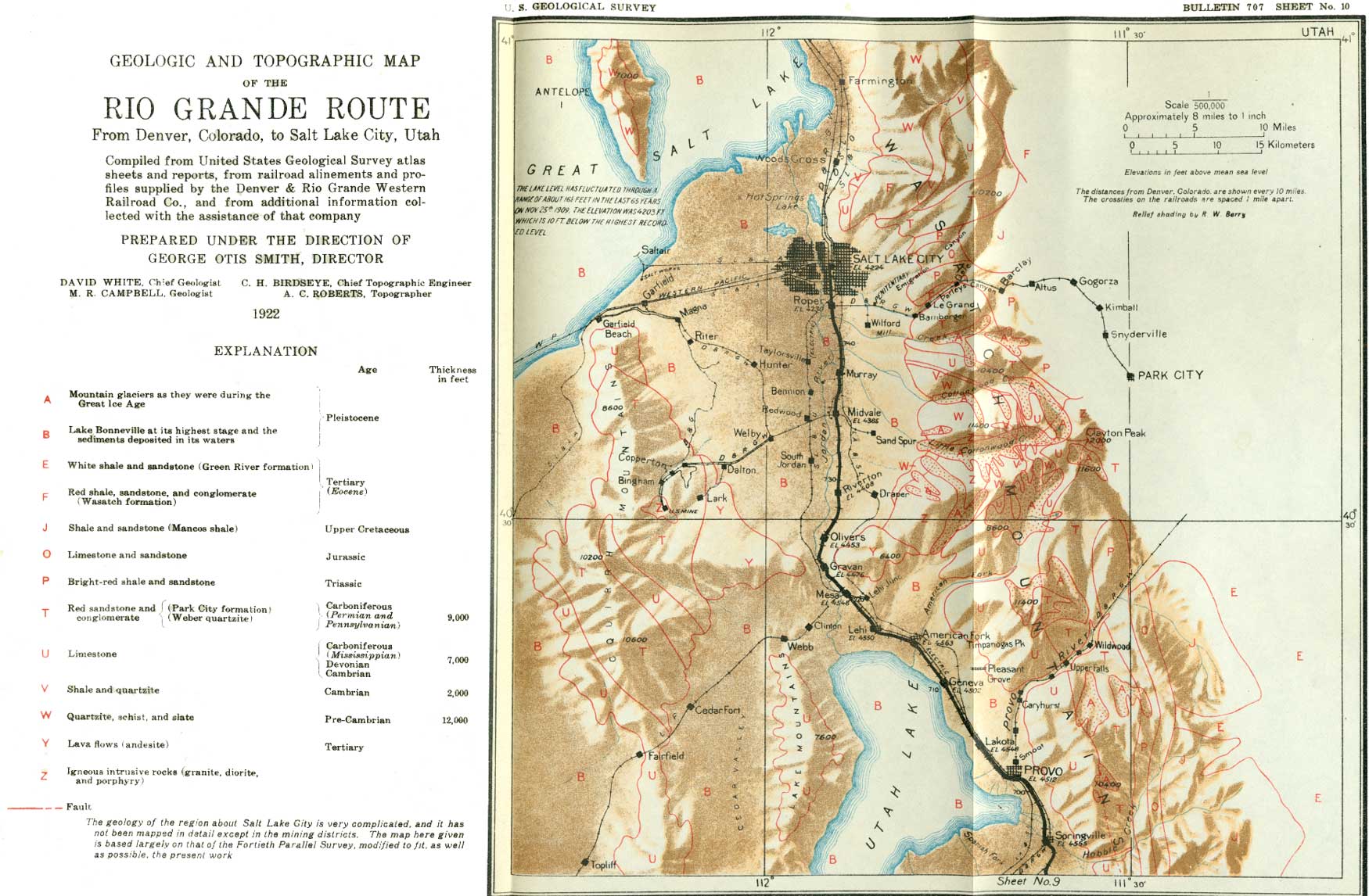
SHEET No. 10 (click on image for an enlargement in a new window) |
|
Springville. Elevation 4,555 feet. Population 3,010 Denver 696 miles. |
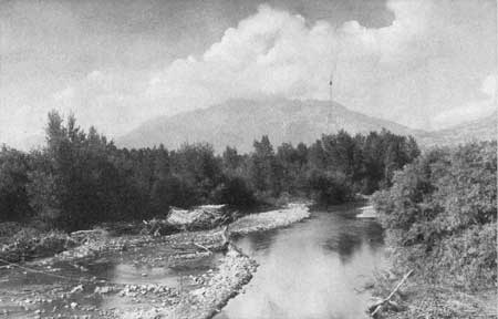
A short distance beyond Mapleton the railroad curves to the right and approaches the edge of the plain. There it begins to descend to a lower plain, which stretches away in the distance as far as the eye can see. Before reaching the level of the lower plain the railroad passes through the flourishing town of Springville (see sheet 10, p. 244), which is surrounded not only by fields of grain, alfalfa, and sugar beets but by orchards that stretch out mile after mile until they seem to be interminable. It is indeed a land of peace and plenty, and an added beauty is given to the scene by the still waters of Utah Lake shimmering in the bright sunshine. A branch railroad turns to the south (left) and runs to the Tintic mining district, 43 miles distant. The town was named Springville because of a large hot spring which issues from the base of the mountain in Hobble Canyon just east of the town. This spring and the stream into which it flows provide an unfailing supply of pure water for the State fish hatchery, which is about a mile from the town on the right of the track.
East of Springville the Bonneville shore line is beautifully developed on the mountain front (see Pl. LXXXIX, A); above it the normal mountain slopes appear, but below it all is covered with the sediment deposited in the old lake.
|
Provo. Elevation 4,512 feet. Population 10,303. Denver 701 miles. |
In a short distance the railroad descends to the lower plain, which it follows to the town of Provo. The shore line in this vicinity is remarkably well preserved and has been named the Provo shore line. At Provo a branch line of the railroad turns directly through the town and the well-irrigated farms to the north and ascends Provo Canyon, which cuts across the Wasatch Range. The canyon winds about the base of Timpanogos Peak, on the north, and here many views of this beautiful peak may be obtained. (See Pl. XC.) The branch line is 26 miles long and terminates at the Mormon town of Heber, which is beautifully situated in one of the level mountain valleys at an elevation of 5,559 feet above the sea.
|
| PLATE XC. TIMPANOGOS PEAK. Timpanogos Peak is one of the most prominent and beautiful peaks of the Wasatch Range. Like Pikes Peak it rise almost sheer from the edge of the plain, and the outlook from its summit is said to be magnificent. Provo River, a clear stream, cuts through the mountain on the right of the peak. Photograph furnished by the Denver & Rio Grande Western Railroad. |
Provo, one of the wealthiest of the Mormon towns, has large manufacturing industries. The following description of the town is given by Stanley Wood:
This pretty little city belongs to the best type of Mormon towns, and a description will serve to give the reader a good idea of the characteristics of all the towns built by the Mormons. The dwellings as a rule are comfortable but not imposing in appearance. Many of them are constructed of adobe or sun-dried bricks, and all are situated in lots of generous proportions and surrounded by ornamental and fruit trees. Water for irrigating purposes flows down each side of the streets, and shade trees in abundance and of luxuriant growth render the walks cool and inviting. Gardens filled with fruit, flowers, and vegetables are the rule, and a quiet, peaceful, industrious, semirural life is the good fortune of the residents here. * * * Provo River furnishes excellent water power, while inexhaustible supplies of artesian water are to be found at a depth of from 40 to 200 feet. The city has, in fact, the finest water supply in any section of Utah. Provo has an excellent public-school system and is the seat of the Brigham Young Academy, which was amply endowed by the first president of the Mormon Church, from whom the school takes its name. Its churches and public buildings, including an opera house, are a credit to its people, who are of a literary taste and inclined to liberality of thought.
One who is not familiar with the development of the Salt Lake Valley can hardly realize that it was first settled little more than 70 years ago, when there were no green spots in the valley except where the mountain streams first spread their waters out upon the valley floor and when most of its surface presented to the eye only the dull gray of the desert. To Brigham Young and the first Mormon settlers must be given credit for far-sighted vision and steadfastness of purpose in carrying out their plan of making this land, where the conditions seemed so unfavorable, a rich agricultural region. Who to-day, without capital other than brains and muscle, would care to undertake the task of making homes in such a place?
In the vicinity of Provo the traveler may have many fine views of the towering wall of the Wasatch Range, deeply cut by canyons and crowned by some of the highest peaks in the region. A little to the north stands the monarch of them all, Timpanogos Peak (Pl. XC), whose barren rocky walls tower 11,057 feet above sea level, or nearly 1-1/4 miles above Provo station. In this western country mountains of this height are not uncommon, and the traveler in his trip across Colorado has seen many that are higher, but seldom can one look from a plain at a wall-like mass such as Timpanogos, whose front is unbroken by cleft, ravine, or spur. The great mass is awe-inspiring, and whoever sees it can only wonder how it was uplifted and whether the movement was rapid enough to have been perceptible had man been there to witness the uplift.
At Provo the Denver & Rio Grande Western Railroad is paralleled on the left by one of the lines of the Los Angeles & Salt Lake Railroad, which divides at Lynndyl; the main line keeps to the west through Stockton and comes into Salt Lake City from the west, and the other, a subordinate line, turns to the east through Nephi and Provo and enters Salt Lake City from the south. Provo is also connected with Salt Lake City by an interurban trolley line, which may be seen on the right on the outskirts of the town.
The country between Provo and Utah Lake is not only well supplied with water from the mountain stream but also has many flowing wells, which are used extensively for irrigation. Many of these wells may be seen from the passing train not only about Provo but also, as far west as Lehi.
Two miles out of Provo the railroad crosses Provo River, which heads far to the east in the Wasatch Mountains and reaches the low plains and Utah Lake on the west through Provo Canyon. About 5 miles from Provo the Los Angeles & Salt Lake Railroad crosses the Denver & Rio Grande Western and continues on the east side to Salt Lake City.
From Provo to Lehi the railroad takes a northwesterly course, following closely the shores of Utah Lake.82 At first the lake is a mile distant, but farther to the northwest the railroad approaches more and more closely, until at the siding of Geneva the waters come to the right of way. The lake is very shallow, and consequently bathers can go out a long distance without danger of entering water beyond their depth.
82Utah Lake is 30 miles long and 6 miles wide at its widest point. Its supply of water is derived from the mountain streams, American Fork, Spanish Fork, Provo River, and Salt, Peteetweet, and Hobble creeks. It is not salt like many of the desert lakes that have no outlet, but its surplus waters flow through Jordan River into Great Salt Lake.
|
Lehi. Elevation 4,550 feet. Population 3,078. Denver 717 miles. |
From Provo to Lehi the railroad passes through some of the best farming land in the valley, and orchards and fields of grain, alfalfa, and sugar beets are on every hand. After passing the point of the lake the next object of interest is the great sugar mill on the right in the suburbs of Lehi. Not only are the beets crushed and the syrup extracted here but much syrup is refined that is produced at other plants and pumped here through long pipe lines. The town abounds in shade and fruit trees, which give it a very pleasing and restful appearance, especially when seen on a hot midsummer day.
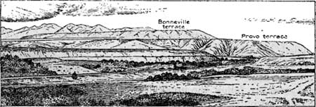
East of Lehi the foot of the mountain is 5 or 6 miles from the railroad, but north of the town the mountain bends suddenly to the west and a long spur is thrust out into the middle of the valley. This long spur on the west face of the Wasatch Range is matched by an equally long, low spur which projects eastward from the Oquirrh Range, nearly cutting off the valley of Jordan River. These projecting points are merely remnants of a lava flow (andesite) that long ago, in Tertiary time, probably filled the valley from the base of one range to the base of the other. This flow may indeed have originally dammed Jordan River, forming a large lake, but if so the river later succeeded in cutting through the barrier a channel that is now known as "The Narrows." During the existence of Lake Bonneville these barriers of lava caused the currents in the lake to set in certain directions, and large quantities of gravel and sand were deposited around and over them in the form of bars or beaches. These terraces, as they appear from the northwest, are shown in figure 61.
|
| FIGURE 61.—Provo and Bonneville lake terraces at the Narrows of Jordan valley, looking southeast. |
Just before reaching Mesa siding (milepost 716) the Denver & Rio Grande Western crosses first the interurban trolley line, which spans Jordan River and proceeds northward along the west side of that stream, and second a branch of the Los Angeles & Salt Lake Railroad, which connects the line running down Salt Lake Valley with the main line at Boulder south of Stockton. The Denver & Rio Grande Western Railroad descends at a steep grade, and at milepost 721 it runs on the right bank of Jordan River, which has gravel bluffs rising more than 100 feet on both sides. The top of the first terrace (about 250 feet above the river), which is crossed by the Los Angeles & Salt Lake Railroad, corresponds with the Provo shore line and doubtless was a gravel bar built out across the channel when the waters of the lake stood at the Provo level. The material composing these terraces is well shown in the numerous cuts of the Denver & Rio Grande Western Railroad and the trolley line across the river and in an immense gravel pit open on the right at a siding called Nash, at the lower end of the Narrows. At this place several large flumes on the left take water from Jordan River and distribute it over the low plain to the north.
The river valley below the Narrows is well farmed and makes a pretty picture as the traveler catches glimpses of it here and there, but the river swerves to the west away from the railroad and the traveler sees it no more. Near the siding of Olivers the railroad emerges upon the plain and the traveler has spread before him on the right the south end of the broad valley in which Salt Lake City is situated, bounded by the great wall of the Wasatch Mountains, as shown in Plate XCI. Here again the shore lines of Lake Bonneville are the most conspicuous features of the landscape. The traveler may readily follow the uppermost or Bonneville shore line by the slight horizontal line across the mountain front which separates the more rugged slopes above from the smoother and more gentle slopes below. Below the Bonneville is another shore line, which in some respects is much more prominent, as it is represented by the uppermost terrace or the great bar built out from the mountains to the east. Below this bar is the terrace which was made when the lake stood at the Provo level and which is crossed by the Los Angeles & Salt Lake Railroad in its course from Salt Lake City to Provo. These terraces are shown in figure 61.
|
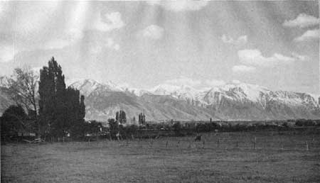
| PLATE XCI. WASATCH MOUNTAINS. The Wasatch Mountains have a very bold and rocky face on the west, and when the tops are covered with snow they make a very striking picture. This view is taken from the level valley floor a short distance south of Salt Lake City. Photograph by Shiplers, Salt Lake City. |
|
Riverton. Elevation 4,408 feet. Denver 729 miles. |
On the left stands the Oquirrh Range in all its barrenness. The traveler may think that this range is the very type of desolation and of worthless barren rock, but if the atmosphere is clear and he studies the mountain carefully, he may see smoke arising from a canyon nearly opposite the station of Riverton, and he may be surprised to learn that in this canyon is the largest copper mine in Utah and, when the method of mining is considered, probably the most wonderful mine in the world. This is the Bingham mine, in Bingham Canyon, a description of which is given on pages 255-259.
North of Riverton the plain upon which Salt Lake City is built stretches to the foot of the terrace at the base of Ensign Peak and eastward to the foot of the mountains. Everywhere in this wonderful valley there are now fine farms, with trees, and in places there are manufacturing plants of different kinds. To-day it is a land of plenty, but it was not so on that memorable 24th of July, 1847, when Brigham Young and his band of faithful followers first looked out over this same valley from the mouth of Emigration Canyon.83 Then it was a desert covered with stunted sagebrush and greasewood, except in places where the mountain streams furnished a supply of water.
83The early history of Utah is a history of the Mormon Church and people, their endeavor to find a home where they would be at liberty to establish their church and social customs without interference and persecution, and the resolute courage of their leading men, who faced the hardships of mountain and desert that they might carry out what was to them the will of God. The tale is fascinating and should be read by all who wish to know something of the early struggles of this people and of the great and wealthy State which they have been largely instrumental in producing.
The story has been simply told by Levi Edgar Young, grandnephew of Brigham Young, and the writer can do no better than to quote his words:
"The first permanent settlement in Utah was made at Salt Lake City by a band of Mormon pioneers from the State of Illinois. This was on July 24, 1847.
"During the winter of 1845-46 the Mormons were making extensive preparations to leave the city of Nauvoo, in the State of Illinois, and to make homes somewhere in the Far West. Their leader [Joseph Smith] had been killed, their property ruined by people not of their religious faith, and, convinced that they could not make a home in Illinois, they had but one recourse—they could move to lands farther west. * * * The Mormons collected all the wheat, corn, bacon, and potatoes that they could and exchanged their land for cattle, horses, and wagons. On February 10, 1846, the first team crossed the Mississippi, and in a few weeks Nauvoo was deserted.
"The Mormons slowly wended their way across the Territory of Iowa and established winter quarters on the banks of the Missouri nearly opposite Council Bluffs. Here they so journed during the winter of 1846-47. They built 700 log cabins and 150 dug outs. * * * At Winterquarters and Kanesville, the two chief camps on the Missouri, about 12,000 people were gathered during the winter. Many died of cold and hunger, for the season was severe. * * *
"The first company of pioneers under Brigham Young left winter quarters in April, 1847. There were 143 men, 3 women, and 2 children. They struck off due west and upon reaching the Platte River continued along its north bank. * * * The company was well organized. Every morning at 5 the bugle sounded to awaken the camp. All assembled for prayers, then took breakfast, and the second bugle was sounded when the company began to march. * * * In June they reached the Black Hills and Fort Laramie. From here they followed the Oregon trail through South Pass to Fort Bridger. There they were given some idea of the kind of country in the vicinity of the Great Salt Lake, but as to the fertility of the soil everyone was doubtful. From Fort Bridger the party went through Echo and Emigration canyons to the Salt Lake Valley. Orson Pratt, Erastus Snow, and some others were sent ahead and entered the valley of the Great Salt Lake July 21. They explored some parts and on the 23d staked off land and turned the waters of City Creek onto the soil. This was the beginning of irrigation in the West. The main party, under Brigham Young, arrived on July 24, and it is out of respect for him and the main company that this day is taken as Utah's natal day. * * *
"The pioneers settled on the present site of Salt Lake City. The first camp was made about where the Knutsford building [Auerbach's department store] now stands at the corner of Third South [Broadway] and State streets, on the banks of City Creek. * * * At a conference held on August 22 it was decided to call the town Great Salt Lake City. * * * Wilford Woodruff says in his journal:
We have laid out a city 2 miles square and built a fort of hewn timber and of sun-dried bricks or adobe. This fort incloses 10 acres of ground, 40 rods of which are covered with blockhouses. [This was called Old Fort and stood on what is now known as Sixth Ward Square, or the park near the Denver & Rio Grande Western Railroad station, now called Pioneer Square.]
"After the first company, headed by Brigham Young, left for the Rocky Mountains, extensive preparations were made for others to follow. The 'First Immigration,' so called, consisted of 1,553 souls under the command of Parley P. Pratt. It left winter quarters on July 4, 1847. * * * There were 580 wagons, 2,213 oxen, 124 horses, 887 cows, 358 sheep, 35 hogs, and 716 chickens. This company arrived in Salt Lake City on September 19. By the end of the year some 4,000 people had settled in the valley of the Great Salt Lake.
"One of the saddest episodes in the history of Utah is the story of the handcart companies. Every year thousands of people from Europe and America gathered at the Missouri River points en route to Utah. * * * How to bring them across the plains was a problem. * * * There was not enough money to provide transportation by wagon for such a multitude, so Governor Young hit upon a unique plan. * * * [The plan was to make handcarts and have the emigrants push them across the plains, with a cow or two for every ten persons.]
"The plan was put in operation in the spring of 1856 and worked well for those companies that started early enough to reach Salt Lake City before winter. In the early autumn of 1856 three large companies of nearly 500 people each arrived in the valley of the Great Salt Lake. They had tramped more than 1,300 miles from Iowa City to Salt Lake City, drawing their supplies in handcarts. * * * For pluck and endurance this is a record that has rarely been equaled.
"Five companies in all undertook the journey that first year, but the two that started last had a dreadful time. James G. Willie commanded one and Edward Martin the other. They had been delayed in leaving the Missouri River and were caught in the piercing blasts of winter on the Platte and Sweetwater. * * * Some of the handcarts broke down; sickness and lack of proper food dispirited the marchers. * * * Thinly clad and poorly fed they labored on and on, and then they were put on half rations when not more than half of the journey was completed. Despair seized them. The company under Edward Martin made a camp in a ravine between the Platte and the Sweetwater in the latter part of October. Food became so scarce that the marrowless bones picked up from the prairies were boiled for soup. * * *
"Brigham Young received word of the sufferings of the emigrants on the plains. He immediately sent a company of the strongest men with wagons and supplies under the command of Joseph A. Young. This rescue party found the companies in a most miserable condition, fed them, and brought them to Salt Lake City. That is, they brought the survivors, for 250 * * * had died on the plains.
"During the four years extending from 1856 to 1860 more than 4,000 emigrants crossed the, plains in this manner, and the total number of deaths was less than 300."
|
Midvale. Elevation 4,365 feet. Population 2,209. Denver 735 miles. |
The train runs along through the valley, with good farms on both sides and the bare walls of the mountains as a background, until it reaches the next station, Midvale, which is the junction point of branch lines running to Bingham, 14 miles to the west. At Midvale is a large mill and lead smelter built for the reduction of some of the ores of the Bingham district. This smelter is known as the smokeless smelter, for it was one of the first smelters to recover and utilize the substances contained in the gases, which usually go off into the air to poison and kill vegetation. (For further information regarding smelters, see pp. 252-254.) At several places along the line the traveler may obtain glimpses of the Wasatch Mountains, and at almost every place he will see the Bonneville shore line as a faint line across the mountain front or the Provo shore line marked by great terraces or embankments of gravel.
|
Murray. Elevation 4,310 feet. Population 4,584. Denver 739 miles. |
The smelting industry has for many years been an important one in the Great Salt Lake Valley, and many smelters have been built at or near the station of Murray. Many of these smelters have been abandoned or consolidated, so that only one now remains—the Murray smelter, of the American Smelting & Refining Co., which may be seen on the right from the train. This plant smelts only silver-lead ores, and the great bulk of the copper ores from the Bingham mines are being treated at the Garfield smelter, the smoke of which may be seen rising over the extreme northern point of the Oquirrh Range on the west (left).
The most prominent object seen by one approaching Salt Lake City from the south is the new State Capitol (Pl. XCII, A), which stands on a commanding terrace north of the city, directly beneath Ensign Peak. The tall buildings also attract attention, though they are not particularly different from tall buildings in other cities. A little farther to the right the traveler may notice the large letter U on the mountain slope far back of the city. This letter was put there by some class of the University of Utah, which stands on the terrace directly beneath it.
|
|
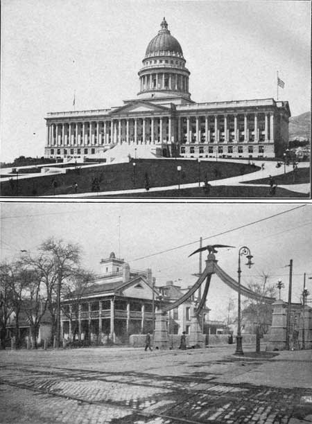
PLATE XCII A (top). STATE CAPITOL OF UTAH.
On the high terrace north of the city stands the beautiful new granite
Capitol of Utah. It overtops all the business houses below and can he
seen from almost all parts of the valley. Photograph by Shiplers, Salt
Lake City. B (bottom). EAGLE GATE AND LION AND BEEHIVE HOUSES OF BRIGHAM YOUNG. The most interesting features in Salt Lake City are the buildings and institutions of the Mormons. This view shows the famous Eagle Gate, erected by Brigham Young in 1853, and the Lion and Beehive houses, where several of his wives lived. Photograph furnished by the Denver & Rio Grande Western Railroad. |
On the same terrace, but a little to the right, may be seen the buildings of Fort Douglas, which has been occupied continuously as an army post since 1862. Still farther to the right is the rather insignificant Emigration Canyon, down which Brigham Young's party came on July 24, 1847, and took possession of the valley. (For a description of the route followed by the pioneers, see p. 248.)
Many travelers unfamiliar with this region imagine that Salt Lake City stands on the shore of Great Salt Lake, but in fact the nearest point of the lake is 10 miles distant. The site of the city was chosen not because of its nearness to the shore of the lake, but because of the abundance of fresh water which comes from the mountains. The city, however, appreciates the value for recreation of such a body of water as Great Salt Lake, and a pavilion called Saltair has been built at the beach, which affords bathing facilities to those who wish to try a dip in the heavy waters (Pl. XCIV, B). It is a popular resort, easily reached by electric train during the season. Saltair is described more fully on page 244.
|
Salt Lake City. Elevation 4,224 feet. Population 118,110. Denver 745 miles. |
The next stop in this journey is at the new passenger station of the Denver & Rio Grande Western Railroad in Salt Lake City, the metropolis of the Great Basin and the home of the hierarchy of the Church of Jesus Christ of Latter-day Saints, more commonly known as the Mormon Church. Salt Lake City, the capital of the great State of Utah, is in the eastern part of the Great Basin, at a point where several routes of travel from the Pacific coast converge into main eastern trunk lines. It has direct connection with Los Angeles on the southwest by the Los Angeles & Salt Lake Railroad; with San Francisco on the west by the Western Pacific and Southern Pacific railroads; with Portland and Seattle on the northwest by the Oregon Short Line and the Oregon Railroad & Navigation Co.'s line; with Butte and Helena on the north by the Oregon Short Line; and with the East by the Denver & Rio Grande Western and Union Pacific railroads. The Union Pacific trains run over the tracks of the Oregon Short Line to Ogden, and the Denver & Rio Grande Western main line also extends to Ogden.
Salt Lake City is the center of a large and prosperous metal-mining district; it has almost unlimited fuel resources in coal fields that lie 100 miles to the southeast, and it stands in the midst of a rich agricultural region that can supply food for many times its present population.
The general traveler, however, will find the chief interest in Salt Lake City in the Mormon people, their mode of life, and the peculiar institutions they have built up.83a
83aSee footnote 83, p. 237.
On July 24, 1847, Brigham Young, at the head of the Mormon pioneers who had traversed the plains and hewed a way through the mountains, as he stood on the foothills after he had emerged from the rocky walls of Emigration Canyon, uttered these memorable words: "This is the place." This statement determined the location of Salt Lake City. Wilford Woodruff in his journal says:
We gazed in wonder and admiration upon the vast valley before us, with the waters of the Great Salt Lake glistening in the sun, mountains towering to the skies, and streams of pure water running through the beautiful valley. It was the grandest scene that we had ever beheld till this moment. Pleasant thoughts ran through our minds at the prospect that not many years hence the house of God would be established in the mountains and exalted above the hills; while the valleys would be converted into orchards, vineyards, and fruitful fields; cities erected in the name of the Lord, and the standard of Zion unfurled for the gathering of the nations.
The pioneers began at once to cultivate the land, but before any of the land was assigned the city was laid out essentially as it is to-day. As each square was planned to contain 10 acres the present city blocks are very long, and one may walk a mile without crossing many of the city streets.
Until about 1871 Salt Lake City was strictly Mormon, but with the development of the railroads and mines Gentiles began to flock in, and to-day the city is thoroughly cosmopolitan.
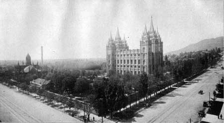
The chief point of interest to the general traveler is Temple Square (see Pl. XCIII), the center or nucleus around which the city was planned and built. This square contains the temple, the tabernacle, and several other minor buildings. The exterior view of the Mormon temple is familiar to most persons. The temple was built of granite obtained in Little Cottonwood Canyon, about 20 miles southeast of the city. It was 40 years in building, and each stone was selected with the greatest care, so as to avoid flaws that might ruin the building in later time. The walls are said to be 9 feet thick and are built throughout of solid granite, and the height to the top of the angel Moroni is 222 feet. As the construction was begun before the days of the railroad most of the stone was hauled by ox team. In view of the fact that it was built without the aid of an architect, the result is surprising, for the temple is indeed an imposing structure and one that would attract attention and command respect-and admiration anywhere. No one save the elect of the church is permitted to enter the temple, so that it has an air of mystery which to most persons is an added attraction.
|
| PLATE XCIII. TEMPLE SQUARE, SALT LAKE CITY. The central point in the plan of Salt Lake City is Temple Square, which is a beautiful park containing the Mormon Temple and Tabernacle. The temple is a handsome gray granite building which, with its graceful towers, dominates the view in this part of the city. Photograph by Shiplers, Salt Lake City. |
The tabernacle, designed as the assembly room for the church conferences, is even more wonderful than the temple. It has a seating capacity of 8,000, but occasionally 12,000 persons have been crowded into it. It was built in the early days, when the people were poor and before the advent of the railroad, and so perforce it was built with home-made materials and by the members of the Church. The roof is the wonderful part of the tabernacle—it was built entirely of wood and is without a single supporting column. The wooden trusses are held together by wooden pins and in places are bound by rawhide. The building is elliptical in shape, 250 feet long, 150 feet wide, and 80 feet high. The acoustic property of the tabernacle is perhaps its most wonderful feature. The dropping of a pin may be heard distinctly the entire length of the building—more than 200 feet. In the belief of the Mormons the architect of these buildings was God, and all their wonderful features are directly due to His beneficent direction.
Many persons are attracted to the tabernacle each week day at noon to hear the organ recitals, which are given free for the entertainment of visitors in the city. The organ, like almost all other parts of the tabernacle, was built before the days of railroad transportation, and so most of its parts were manufactured on the spot. Recently it has been rebuilt, without, however, changing the architectural effect, and now it is said to be the largest organ in the world. The total number of pipes is between 7,000 and 8,000.
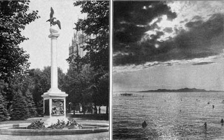
Temple Square is a delightful park in the heart of the city, and with its flowers, trees, and greensward it forms a beautiful setting for the massive buildings. One of the most attractive and interesting monuments recently added to this park is that of the Sea Gulls (see Pl. XCIV, A), which was designed by Mahonri M. Young, a grandson of the great pioneer leader. This monument commemorates an incident in the experience of the early pioneers which shows their implicit faith in the protecting power of God. The gulls which inhabit the shores and islands of Great Salt Lake are held in high regard, if not reverence, by the Mormon people, for the reason that they saved the pioneers from starvation in the early days. As the story is extremely interesting it is given in full, as narrated by those who are supposed to know.
|
|
PLATE XCIV. A (left). SEA GULL MONUMENT, SALT LAKE CITY. A monument
to commemorate the destruction by sea gulls of the hordes of crickets which,
in 1848, threatened the crops and indirectly the lives of the pioneers in the
Salt Lake valley. Their intervention is regarded by the Mormon people as due
to Divine Providence, and this beautiful column is intended to express their
gratitude. Photograph by the Utah Photo Materials Co. B (right). BATHING IN GREAT SALT LAKE. The opporunity to bathe in the heavy waters of Great Salt Lake attracts many travelers. The lake is so shallow that the bather may go far out without getting beyond his depth, and even when he is in deep water the amount of salt in the water is so great that sinking is almost impossible. Photograph furnished by the Denver & Rio Grande Western Railroad. |
The pioneers reached the valley in the summer of 1847 with few personal possessions besides those which they carried on their backs. They at once made preparations to plant, so that the colony might have food for the coming year, but as they arrived in midsummer little could be grown that year. The next spring 5,000 acres of wheat were planted, and the prospects seemed good for an abundant crop. During the last week in May, however, the black crickets began to attack the growing wheat, as well as everything else that was green. At first the crickets were confined to certain fields, but soon they spread, and in a few days they had swept much of the valley.
As soon as the extent of the impending calamity was realized the people began to fight the common pest at every point. They drove them into ditches and upon piles of burning reeds, striving in every way to stop the flood of destruction, but all in vain. The people then became greatly alarmed lest their whole crop should be destroyed and they should be left to starve, so a day of fasting and prayer was appointed, as the people had great confidence in the power and willingness of God to help the faithful.
The result has been regarded by all the people of Utah as a miracle and as a direct answer to their supplications. From the shores and islands of Great Salt Lake came myriads upon myriads of gulls until the sky seemed dark with their wings and the air seemed to pulsate with their wild cries. The people were fearful that a new enemy of destruction was upon them until they saw the gulls alight on the fields and begin to devour the crickets. As the gulls came by thousands it was but a short time until the fields were cleared of the pest, and then the gulls wheeled into the air and departed for their island homes. It is no wonder that the people look upon the advent of the birds as a direct answer to their appeal to God and that even to-day the gulls are regarded as the great protectors of the Mormon people.
The gull has been selected as the emblem of the State, and the monument recently erected in Temple Square (Pl. XCIV, A) is intended to express the gratitude which the Mormon people feel for the deliverance from the disaster that threatened the early settlers. The gull also appears on the main piece in the handsome silver service given by the State to the battleship Utah.
Temple Square is the center of the Mormon stronghold in the city, for around it are clustered many buildings of historic interest and also those used by the church at the present time. These buildings include the new Utah Hotel, built by the church, the church tithing house, Lion House, Beehive House (the home of Brigham Young and his many wives), Amelia Palace, and Eagle Gate, erected by Brigham Young (Pl. XCII, B). Across the street is the great Zion Cooperative Mercantile Institution or Z. C. M. I., as it is familiarly called. The Deseret News, founded in 1851, occupies the other corner, and many other buildings belonging to the church are scattered throughout the city. There are also fine club houses, a public library, and numerous skyscrapers and manufacturing plants.
The city derives its water supply from the many canyons that seam the front of the Wasatch Mountains. The first of these streams to be utilized was City Creek, which cuts through the terrace east of the new Capitol Building. City Canyon has been made into one of the most charming parks in the country, so that it serves the double purpose of keeping the water supply uncontaminated and providing an outing place for the people. The streams in the other canyons have been requisitioned by the city, and now much of the water comes from Big Cottonwood Canyon, more than 20 miles to the south.
The city is noted for its fine shade trees and for the beautiful velvety lawns which abound almost everywhere, especially around the public buildings and, the handsome residences on Brigham Street. There are some warm sulphur springs and bathhouses at the foot of the terrace in the northwestern quarter of the city.
| <<< Previous | <<< Contents >>> | Next >>> |
bul/707/sec6c.htm
Last Updated: 16-Feb-2007