
|
Geological Survey Bulletin 707
Guidebook of the Western United States: Part E. The Denver & Rio Grande Western Route |
ONE-DAY TRIPS FROM COLORADO SPRINGS.
(continued)
PIKES PEAK.
Manitou is the place from which the start is made on the Cogwheel Road for the ascent of Pikes Peak. Pikes Peak, the highest mountain in this part of the system (14,109 feet), was named for its discoverer, Lieut. Zebulon M. Pike, who was commissioned by President Jefferson to explore certain parts of the western country acquired from France by the treaty of Paris, signed April 30, 1803, and generally known as the Louisiana Purchase. Pike had already made a trip to the source of the Mississippi when he was directed to explore what was then known as the "Southwest." He and his party left Missouri in July, 1806, and went across the country to the Arkansas and up that valley to the site of Pueblo. At the mouth of Purgatory Creek he caught sight of Pikes Peak, far to the north. Pike; in his journal, calls it the "Grand Peak." He was fired with the ambition to climb it, so he started off from his camp at the site of Pueblo, on Arkansas River, supposing that he could easily reach its summit and return in the course of a few days. He was not accustomed to the clear air of the mountains and did not realize that the peak was 45 miles distant in an air line and about 9,500 feet above him. The party traveled directly toward the peak, and finally, on November 27, 1806, after great hardships, they reached the summit of the plateau, at an altitude of probably 9,000 feet, far south of the peak. The mountain was covered with snow, and they saw that they were but little more than halfway to the top. As they were not prepared for such cold weather, they suffered severely and concluded that it was then impossible to reach the summit. They returned as they came and then pursued their way up the river toward the site of Canon City.
The first person to climb to the summit of Pikes Peak was Dr. Edwin James, botanist, geologist, and surgeon of Maj. Long's expedition, in 1820.16 On account of this ascent Maj. Long named the mountain James Peak, and it was called by this name for a number of years. Eventually, however, the name of its discoverer, Pike, was given to the mountain, and it is now firmly fixed as the most appropriate one that could have been chosen.
16The Long expedition came to this region over practically the same route that the traveler on the Denver & Rio Grande Western has followed south from Denver. Maj. Long camped at the mouth of Monument Creek (Colorado Springs) to allow Dr. James an opportunity to climb the mountain called by Pike the "Grand Peak." On July 13, 1820, Dr. James and two companions started for the mountain. After dining at the "boiling spring" (Soda Spring at Manitou) they began the ascent of the mountain, taking with them only a single blanket. They camped on their way up, probably before they got to the timber line, and spent a very uncomfortable night. After much hard climbing the party reached the summit about 4 o'clock in the afternoon. In their descent they lost their way and were obliged to spend another night on the mountain side without food or blankets. On the morning of July 15 they continued their descent to the boiling spring, where Dr. James entered the following note in his journal:
"A large and much frequented road passes the springs and enters the mountains, running to the north of the peak. It is traveled principally by the bisons; sometimes also by the Indians, who penetrate here to the Columbia."
Evidently Ute Pass was used as a thoroughfare long before the white man was familiar with the region. The geologic cause of this low pass is stated on page 40.
Pikes Peak stands at an altitude of 14,109 feet, or more than 1-1/2 miles (7,920 feet) above Colorado Springs. Its summit may be reached by the Manitou & Pikes Peak Railway, better known as the Cogwheel Road, or by automobile over the road recently completed from Cascade to the top. The first part of the Cogwheel route through Engelmann Canyon, which is nearly filled with large granite boulders, is very picturesque. The small stream tumbles over the great blocks of rock in continuous cascades, and overhead and around is the deep green of the native forest. Near the upper end of the canyon is the intake of the main that supplies Colorado Springs and Manitou with pure, cold mountain water. The water supply of these towns is derived not only from this particular valley but is gathered by a system of tunnels and canals from a number of rocky basins whose natural outlet is to the west.
After passing through the rough part of Engelmann Canyon the road emerges onto a comparatively level terrace of the mountain side at an elevation of about 9,000 feet. On this terrace the ancient glaciers that came down from the high peak above dumped great quantities of loose fragments of rock in ridges that are called moraines. The ice has disappeared, but the moraines still testify to the existence and the extent of the ice. The most conspicuous moraine to be seen from the Cogwheel Road is that which encircles and holds in place Lake Moraine, on the left. The moraine had formerly been breached by a stream, but it has been artificially restored to its original condition, and it now holds a lake of considerable size.
The surface of the mountain above timber line consists of granite, which is bare except where it is covered by snow. After circling around a long spur that projects to the south the train arrives at the summit. On the east are Colorado Springs and Manitou, which look like small villages or gardens spread at the foot of the mountain, and still farther east are the plains, which stretch like a carpet as far as the eye can see. On the west and southwest the mountains roll like the billows of the sea far into the hazy distance. The Sangre de Cristo and the great Sawatch ranges tower like giant rollers high above the others, as if the sea had been consolidated at the very moment of its greatest agitation. On the north is the Rampart or Front Range, but in this direction, instead of rugged mountains, one sees only a gently undulating plateau, which from this great height looks much like the plains on the east except that it is dark with a growth of evergreen trees.
To the traveler who is unfamiliar with high altitudes one of the most striking features here is the effect of weathering on the rocks. The summit and the slope on the southwest side for some distance down are covered with blocks of granite that have been broken from the massive rock that forms the top of the mountain. The rocks on the summits of all high peaks are broken and thrown down in the same way, evidently through the rigors of the climate in such high and exposed places. The warm rays of the sun during the day expand the rocks and melt some of the snow, and the water, so formed sinks down in cracks and crevices and during the ensuing night freezes. The expansion and contraction of the rocks due to changes in temperature and the freezing of water in joints and fissures soon break to pieces even the most massive granite, as shown on the summit of the peak.
The first railroad that was projected up Pikes Peak was an ordinary steam road. It was planned to follow a circuitous route with a maximum gradient of 250 feet to the mile and to reach the summit in a distance of 30 miles. Construction was started in 1884, and about 8 miles was graded when the scheme failed through lack of financial support. Surveys for the present road were begun in 1888, and the golden spike was driven on October 20, 1890. The maximum gradient of this road is 1,320 feet to the mile, and the length is 9 miles.
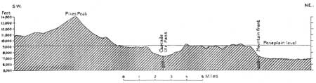
The automobile road reaches the same point on the summit that is reached by the Cogwheel Road. The length of the road is 18 miles; its average grade is 370 feet to the mile, and its maximum grade is 554 feet. The view from the automobile road is even more impressive than that from the Cogwheel Road, for, owing to the numerous bends, the traveler can see the ever-widening landscape on all sides. The route passes through Manitou and up the narrow defile of Ute Pass, at first over the edges of the eastward-dipping quartzite and then over the underlying granite. The road as well as the contact between the quartzite above and the granite below is well shown in Plate XXIV, B. At the village of Cascade the new road turns and climbs the west wall of the canyon, and as it rounds the point directly above Cascade the traveler can look down the pass to Manitou, far in the distance. The road follows Cascade Creek for some distance in a canyon hemmed in by granite walls, but these grow less and less steep as the automobile moves on until finally the road passes by a gentle grade from the head of the valley to the divide between Cascade and Catamount creeks. At this height, about 9,250 feet, the traveler gets a wide view, particularly to the north, and he may note that the sky line, as shown in Plates XV, A, and XXIV, A, is as level as that of the plain about Colorado Springs, except that here and there low knobs rise island-like above the level surface, and far away in the hazy distance he can just make out the blue outline of Tarryall and Mosquito ranges. Could the traveler, however, cross the apparently level plain at which he is looking he would find that it is smooth only in appearance from a distance, for it is really cut up into numerous ravines much like the one followed by the automobile road. Another feature which the traveler will probably notice on the surface of this plain is the deep and perfect disintegration of the granite rock which composes all this country. No ledges of rock can be seen, and the soil is made up largely of small fragments of granite broken up by the action of the weather. This even surface is well shown in Plates XV, A (p. 31), and XXIV, A, and its relation to Pikes Peak is shown in figure 11.
|
| FIGURE 11.—Profile section through Pikes Peak and Cascade, showing the relation of the mountain peak to the lower land (peneplain) on either side. |
This plateau can be traced northward at least as far as Denver. It is the result of long exposure to the action of the weather and the cutting of the streams when the entire region was at a much lower level than it is to-day—so low, in fact, that the streams could cut no lower—and it remained in this position so long that most of the hills and other inequalities of the surface were worn away and the region was reduced to a plain as truly as the country about Denver and Colorado Springs is a plain to-day. That was long, long ago, as man measures time, even before man was there to see any of the operations that produced the change.
Then came a slow but steady uplift of the mountain region and probably also of the plain, until the land reached its present height above sea level. Such an uplift accelerated the streams, and they soon cut deep canyons—such as Ute Pass and the canyon of Cascade Creek—in the surface of the plateau, until to-day it is level only as one looks across broad tracts of its old surface and at a distance so great that the details fade and the plain looks as it once did before the uplift came. At that time, owing to the fact that the rocks of Pikes Peak are more resistant than those of other parts of the region, the mountain stood nearly 5,000 feet above the surface of the plain, just as to-day it stands nearly 5,000 feet above the surface of the plateau.
From the plateau the slopes of the mountain above appear to be unscalable by a road, and it is only by constant turning and looping back upon itself that the road finally reaches what appears from below to be the summit but what is really a long spur of the mountain that branches off to the northwest. The northern slope of this spur, up which the traveler came, is very steep, but the opposite slope is so gentle that it scarcely can be considered mountainous. The difference in the appearance of the two slopes is well shown at a place called "the Bottomless Pit." Here the traveler may stand in his automobile and gaze down on the north into a jagged pit about 1,700 feet deep, whereas on the other side the slope is very gentle. As the rocks are the same on both sides of the ridge there must be some cause other than rock texture for this great difference in appearance. Geologists recognize that the steep, jagged slopes on the north side are the result of the action of moving ice, but the traveler may inquire: Where is the ice? The climate here is now so mild that practically all the snow which falls in the winter is melted away during the succeeding summer, but ages ago the climate of all the United States was much more severe than it is to-day, and large glaciers were formed on almost every mountain peak. The most favorable place for the snow to accumulate was on the north and east sides, for it was not blown away by gales coming from the west, and it was protected from the heat of the sun more than it would have been on the other sides. Thus the glaciers were restricted to the north and east sides, or at least they were more numerous and larger there than they were on the other sides.
In that far-off time fairly large glaciers lay on the side of Pikes Peak, and they gouged out great amphitheaters or cirques, as they are generally called, in the mountain side. In this manner the original more gentle slope was converted to nearly vertical walls. The rocky material that was removed from these cirques was carried down by the glacier and deposited at its extremity as a ridge or moraine or was washed down Fountain Creek. If the traveler wishes to see how steep are the cliffs produced by a glacier he has only to walk to the end of the Cogwheel Road and look down a thousand feet or so into the rocky basin that the ice has cut.
| <<< Previous | <<< Contents >>> | Next >>> |
bul/707/trip2a.htm
Last Updated: 16-Feb-2007