
|
Geological Survey Bulletin 845
Guidebook of the Western United States: Part F. Southern Pacific Lines |
GUIDEBOOK OF THE WESTERN UNITED STATES.
PART F. SOUTHERN PACIFIC LINES, NEW ORLEANS TO LOS ANGELES.
By N. H. DARTON.
INTRODUCTION
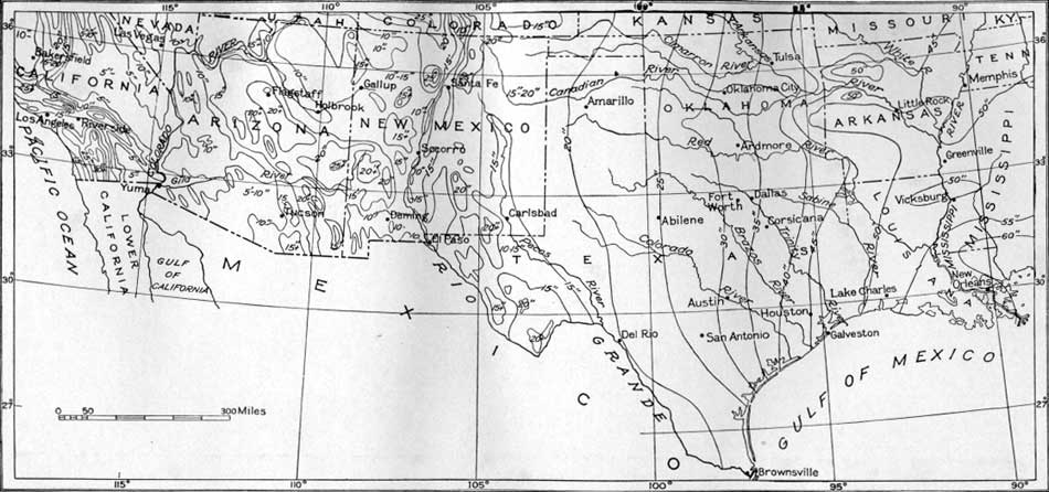
The Southern Pacific Railroad from New Orleans to Los Angeles, a distance of about 2,000 miles, passes through a region exhibiting a great variety of geographic and industrial conditions. The climate, especially the amount of precipitation, is the most influential factor in causing this variety. (See pl. 1.)
|
|
PLATE 1.—MAP SHOWING PRECIPITATION IN THE SOUTHWEST. (click in image for an enlargement in a new window) |
The low Coastal Plain of southern Louisiana and eastern Texas, with ample rainfall and thick rich soils, is a province distinct in configuration, human occupations, and products. There are extensive swamps, prairies, and wooded areas, but a large part of the land is under cultivation, with sugarcane, cotton, and rice as the principal crops. The streams are wide and slow, the winter climate is mild, and the summer heat is tempered by breezes from the Gulf of Mexico. Flourishing towns occur at short intervals, and some of them are growing rapidly. The entire region is underlain by a great thickness of sand and clay of alluvial origin.
In central-eastern Texas the Coastal Plain is higher, the soil conditions are materially different, the streams run more swiftly, swamps become rare, and although much land is under cultivation, many areas are either in pasture or not cleared. The vegetation changes with change of soil and increase of altitude, and the crops are more diversified than in the lower parts of the Coastal Plain. The region is underlain by sandstone, shale, and other formations, which rise toward the west, cropping out in regular succession as they are crossed from east to west. Some of these formations are hard enough to make ridges and knobs, and there is general terracing at various levels. Parts of the highest lands are remnants of an old plain of former wide extent.
Beyond San Antonio the traveler observes several changes in the general aspect of the country, for although the Coastal Plain extends west to Del Rio, there is both a gradual increase in elevation to about 1,000 feet and a marked diminution of rainfall to the west, which greatly affect landscape and industries. Cacti become larger and more abundant, and many special trees and plants are prevalent, notably the mesquite; forests diminish in density, and far to the west trees occur only in the bottom lands. Agriculture here depends largely on irrigation, and the raising of cattle, sheep, and goats is the dominant industry. The principal underlying rocks are shale, soft sandstone, and chalk, which do not make strong relief but produce hills and ridges of moderate height separated by wide valleys, which along the larger streams are bordered by bottom lands. Northwest of San Antonio the Coastal Plain gives place rather abruptly to the Edwards Plateau, owing to the rapid rise of hard limestones; from San Antonio to Del Rio this feature lies north of the railroad but is visible at many places.
For many miles west from Del Rio the railroad is on the plateau, which is floored by hard limestone and deeply trenched by the drainageways, notably by the canyons of the Devils River, the Rio Grande, and the Pecos River. In this district, where semiarid conditions prevail, vegetation is sparse and trees are mostly confined to valley bottoms except where the limestone supports a growth of juniper or live oak. The soil is thin, but it sustains grass and shrubs which afford good pasturage for many goats, sheep, and cattle. Owing to the gradual general rise of the strata to the west the land increases in elevation, and much of the plateau in south-central Texas is 2,000 feet above sea level in its eastern part and 3,000 feet in its western part. Near Sanderson this rise develops into the great dome of the Marathon uplift. The central part of this uplift is truncated, revealing a large area of closely folded Paleozoic rocks, making sharp ridges of the Appalachian type. The Edwards Plateau ends on the east side of this uplift. To the west is the Davis Mountain region, a wide province of volcanic rocks, characterized by rugged peaks and irregularly disposed ridges in great variety, which rise to elevations considerably more than 6,000 feet.
The volcanic rocks continue far west of Marfa, but near that place begins the Basin and Range province, which extends thence across New Mexico, Arizona, and southern California. In this province there is a prevalence of long ridges separated by wide plains or bolsons floored by sand and gravel. They present a succession of strata or of volcanic flows, mostly tilted or flexed and faulted. Many of the great mountain faces stand along lines of uplift. At intervals there are large masses of intrusive rocks, which have been forced up in a molten condition and are now so hard that they are conspicuous topographic features.
The climate of this region is arid or semiarid. The Rio Grande flows between ridges in New Mexico, but at and below El Paso it either crosses the axes of the ridges in canyons or passes around their ends. The Gila and Colorado Rivers have similar relations in southwestern Arizona after leaving the canyons in which they cross the Arizona Plateau. The mountains of the Southwest are rocky and jagged, and the meager vegetation is so scattered that they appear to be bare. The broad desert plains of gravel and sand between the mountains likewise sustain only scant vegetation, for this is the most arid province in the United States. Parts of it, however, that have water for irrigation are highly productive.
The San Bernardino, San Jacinto, and associated mountain ranges in California form high barriers on the north and west sides of the Salton Basin which intercept the moist air currents from the Pacific and thus cause the aridity that prevails over a wide area to the east. These mountains are uplifted blocks, made up largely of granitic and metamorphic rocks.
In southern California lowlands extend from the mountain slopes east of Redlands to the Pacific Ocean, a distance of about 120 miles.
The surface slopes mostly to the west and south and is diversified by scattered rocky ridges. The climate is mild, and although the precipitation is only moderate in amount, water is available for irrigation and wide areas are under cultivation for citrus fruits, grapes, nuts, and many other valuable crops.
In these days of wide culture it is hardly necessary to point out the practical utility of geologic knowledge and the relation that exists between geology and the occurrence of nearly all materials of economic value. Soils are derived by geologic processes from rocks of various formations. Ores, minerals, oil, coal, and water all have close relations to the structure and history of the geologic formations in which they occur. Some igneous rocks carry or have been the source of ores, and their history and relations have much to do with mining.
The order and general succession of the strata making up the rocky shell of the earth are shown in the table on page II. The oldest rocks now seen at the earth's surface include some granites and other crystalline rocks, partly of igneous origin and partly of other types that have become crystalline through the agency of heat and pressure within the earth and have later been exposed by erosion. These are overlain by a great succession of sedimentary strata (laid down by water), consisting of sandstone, limestone, and shale, which have a thickness of many thousand feet. Some of these later rocks have also been altered by heat and pressure into schist, marble, and quartzite. In many areas there are lavas, ash, and tuff extruded by volcanic action at various times, some of it recent. Seas, lakes, and rivers have been the principal agents in depositing sand, clay, and limy sediments, which have later become sandstone, shale, and limestone. In general, sands were deposited mainly on the shores and by streams, clays in quieter waters, and limestones in deeper waters, so that these various materials indicate the geologic conditions at the time of their deposition. The wind has also played some part in the accumulation of sand, and much detrital material has been moved by glaciers. The character of the rocks and the order of the sedimentary succession vary in different regions; thus a system may be fully represented in one district and be entirely or partly absent in another, owing to lack of deposition or to removal by erosion in an interval of uplift. In some places a portion of geologic time may be represented by limestone alone, while in others the same portion is represented by shale, sandstone, or volcanic rocks. Fossil shells, bones, and other parts of organisms throw light on the succession of sedimentary rocks, for they mark the progress of life development through geologic time; they are the key to geologic problems, such as the structure and order of formations, that in many places could not be solved without them.
The total thickness of the sedimentary formations is many thousand feet, and the time represented is hundreds of millions of years.
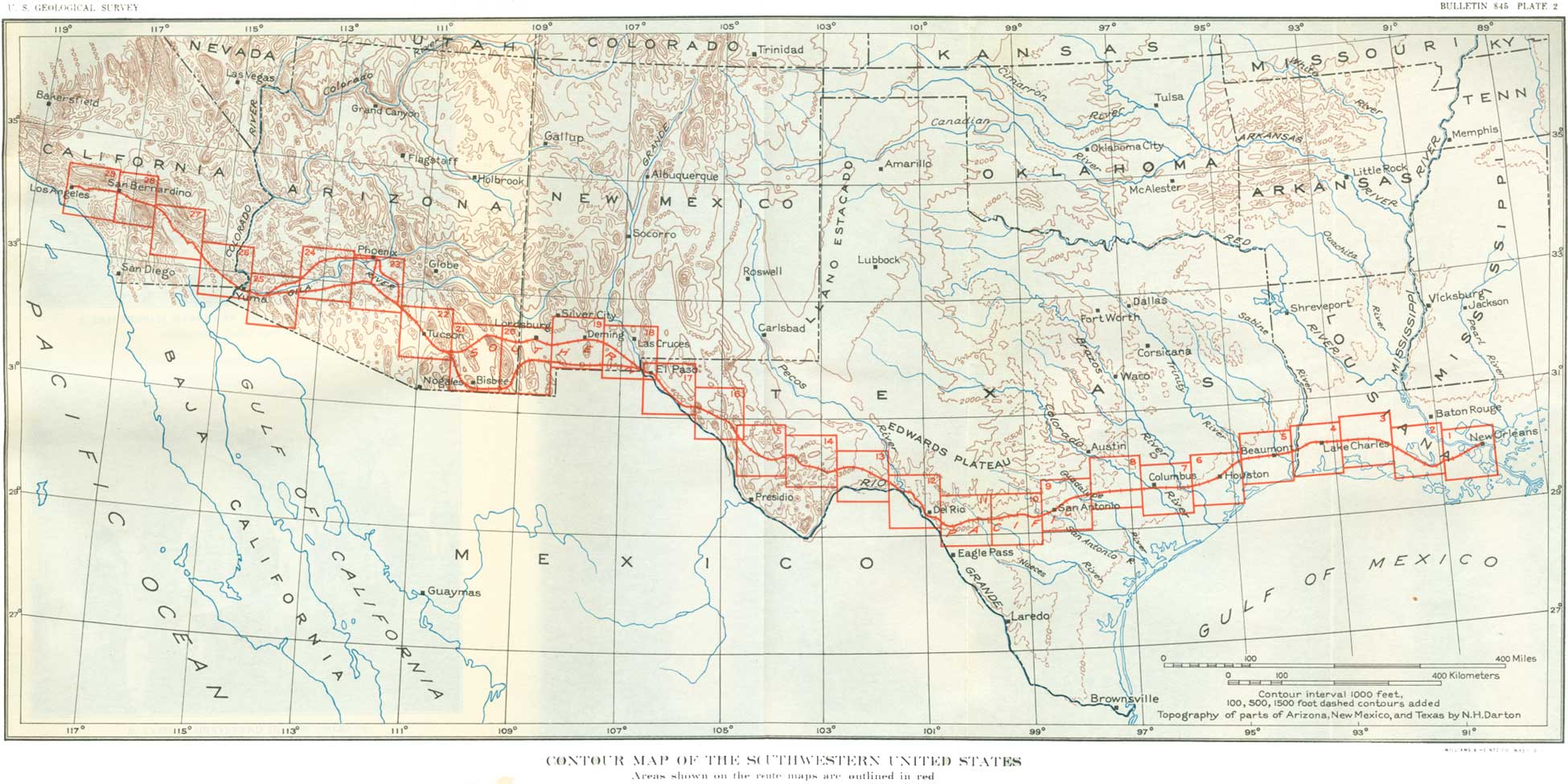
NOTE.—For the convenience of the traveler the sheets of the route map in this bulletin are so arranged that they can be unfolded one by one and kept in view while reading the related text. The contour lines, in brown, represent elevation above sea level. Each line indicates the path that would be taken by one who walked over the country by a course always at the same level, curving in and out with the irregularities of the land surface. The lines are drawn at the vertical distances apart ("contour interval") stated on each map; where these lines are close together they indicate a steep slope; where they are far apart, a gentle slope or plain. Most of the contour lines have been compiled from detailed topographic maps published by the United States Geological Survey, the names of which are given in the southwest corner of each. In some areas the contour lines are taken from surveys by the Engineer Corps, U. S. Army, and the Los Angeles Department of Water and Power, and from reconnaissance by the author. A reference to each map is made in the text at the place where it should be unfolded. The areas covered by these sheets are indicated on Plate 2, and a list of the sheets and the other mustrations is given on pages III-VII.
|
|
PLATE 2.—CONTOUR MAP OF THE SOUTHWESTERN UNITED STATES. (click in image for an enlargement in a new window) |
Figures given on mileposts in Louisiana indicate miles from Algiers, a Southern Pacific freight terminal on the south bank of the Mississippi River opposite New Orleans; they are about 1-1/2 miles less than the distance from the Union Station, New Orleans. West of Houston the mileposts give distances from Harrisburg, an old terminal off the present main line about 3 miles south of Houston station. West of El Paso the mileposts give distances from San Francisco. As a rule the mileage given on the posts does not allow for differences due to subsequent shortening or lengthening of the line. Most of the elevations at stations given in this guidebook are those furnished by the railroad company, but others are derived from precise levels of the United States Coast and Geodetic Survey or the United States Geological Survey.
The statistics given in this guidebook are taken mainly from official Government sources, such as the United States Census and the United States Bureau of Mines. Some have been derived from local sources that are believed to be reliable, and these are credited to the respective authors. Statistics not otherwise credited are to be understood as obtained from official Government records, whether so stated or not. Authors' names cited in parentheses refer to the bibliography on pages 293-296.
| <<< Previous | <<< Contents >>> | Next >>> |
bul/845/intro.htm
Last Updated: 16-Apr-2007