
|
Geological Survey Bulletin 845
Guidebook of the Western United States: Part F. Southern Pacific Lines |
ITINERARY
|
|
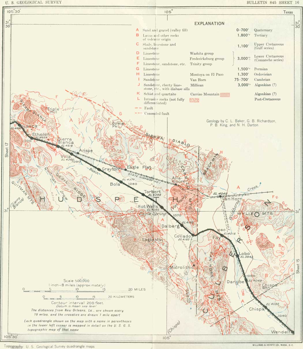
SHEET No. 16 (click in image for an enlargement in a new window) |
|
Chispa. Elevation 4,088 feet. Population 18.* New Orleans 1,043 miles. |
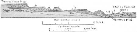
From Chispa siding there formerly was a branch railroad (of which the grade is still visible) that passed through a gap (Chispa Summit) between the north end of the Tierra Vieja Mountains and the south end of the Van Horn Mountains and thence turned southward to the San Carlos coal mine. This mine yielded considerable coal, but apparently the enterprise could not compete with the producers of petroleum fuel. In the gap through which this branch railroad passed there is an interesting thumb-shaped plug of volcanic rock, plainly visible from Chispa siding and points beyond, which is the remains of a volcanic vent, probably of Tertiary age. The general relations in the mountain as viewed from Chispa are shown in Figure 15. The hard beds give rise to tables and cliffs and the softer strata to the intervening slopes. North of Chispa is Chispa Mountain, a sharp peak of volcanic rocks.
|
| FIGURE 15.—Profile of the northern part of the Tierra Vieja Mountains south of Chispa siding, Tex. Tl, Tertiary lava; Tt, Tertiary tuff; Ks, Upper Cretaceous shale; Kef, Eagle Ford formation (Upper Cretaceous); Kg, Georgetown limestone (Lower Cretaceous) |
The Van Horn Mountains,72 which lie north of the gap west of Chispa siding, cause a long northward deflection of the railroad.
72The Van Horn Mountains present a wide area of strata of Lower Cretaceous (Comanche) age, overlain in the high central part and the northeast end by Tertiary volcanic rocks. The Cretaceous strata are about 2,000 feet thick, with a coarser conglomerate at the base, a thick mass of Cox sandstone above, and then representatives of the Finlay limestone and limestones of the Fredericksburg group. In the eastern part of the range the strata lie nearly horizontal, with a steplike outcrop of the harder beds. At its north end limestones of Permian age rise to the surface in the high uplift of the Van Horn region. To the south, near the gap west of Chispa, there is a strong downward pitch and downfaulting of a block consisting of a thick succession of the Upper Cretaceous rocks that make up the north end of the Tierra Vieja Mountains.
The main ridge of the Van Horn Mountains is an anticline of considerable prominence. Crossed by a fault (west to east) with drop on the north side, 8 miles northwest of Chispa, the anticline rises to the north so that the limestone of Permian age finally appears, overlapped by Trinity beds in the north end of the range. The Finlay limestone in this range consists of about 400 feet of gray earthy limestone containing, according to Baker, Enallaster texanus, Exogyra quitmanensis, Cryphaea marconi, Requienia, and Tylostoma. The Edwards limestone is thin in the Van Horn Mountains, apparently comprising only 25 feet of beds at the south end of the range, near Chispa Summit. It is a massive bluish rock grading down into some slabby beds supposed to represent the Comanche Peak and Walnut clay. The representative of the Georgetown in this area consists of nodular limestone and marl underlain by a bed of brown sandstone and capped by a heavier-bedded limestone, in all about 500 feet. In exposures 9 miles southwest of Lobo siding there have been collected from this formation, according to Baker, Pervinquieria graysonensis, P. wintoni, Holaster simplex, and Holectypus limitis. At the fault 3 miles west of Chispa Summit the sandstone noted above lies on Edwards limestone and is overlain by nodular impure blue-gray limestone of Georgetown age, which carries Enallaster texanus, E. bravoensis, Hemiaster calvini, Holectypus planatus, Kingena wacoensis, Neithea texana, Cypricardia texana, and Cryphaea corrugata. These beds are overlain by slabby limestones and shales of the Eagle Ford formation, which are highly fossiliferous at Chispa Summit, where besides the characteristic Inoceramus labiatus many fine ammonites have been collected. These include, according to Adkins, Mantelli ceras aff. M. couloni (D'Orbigny), Romaniceras cumminsi Adkins, R. loboense Adkins, Coilopoceras eaglefordense Adkins, C. chispaense Adkins, Pseudoaspi doceras? chispaense Adkins, Pagesia texana Adkins, Thomasites sp., Neoptychites aff. N. gourguechoni Pervinquiere, Hoplitoides? mirabilis Bose, Neocardio ceras septem-seriatim (Cragin), Scaphites aff. S. africanus Pervinquiere, S. aff. S. aequalis Sowerby, and Metaptychoceras aff. M. smithi (Woods).
These fossiliferous strata pass under shales with thin limestone layers equivalent to the Austin chalk, and these in turn are overlain by shales of Taylor age, which are exposed far to the south along the west side of Tierra Vieja Mountains to and beyond the San Carlos coal mine. At this mine, according to Dumble, they carry Nautilus dekayi?, Schloenbachia delawarensis, Baculites asper, B. ovatus, Placenticeras guadalupae, Ostrea elegantula, Exogyra costata var., Trigonia thoracica, Cardium alabamense, and many others—a fauna which is regarded by Stanton as lying between the Navarro and the Austin limestone. A good specimen of a tooth of Ptychodus mortoni Agassiz was found.
|
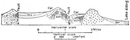
| FIGURE 16.—Section across the Van Horn Mountains near their north end. Kts, sandstone Cox); Cpl, Permian limestone; sch, Carrizo Mountain schist; Qal, alluvium; Ti, igneous rock |
For several miles near Danube siding the railroad is margined by a dike or levee of earth to protect the tracks from washouts. The erosion and flood-water conditions in the valleys of the arid regions are somewhat peculiar. Most of the infrequent rain falls in heavy showers, or "cloudbursts," which quickly flood the drainageways with a swiftly moving body of water sufficiently powerful to roll large boulders and to transport a vast amount of fine material far down the side slopes. These floods often cut deeply into the railroad embankments, so that it is necessary to provide long deflection ditches and dikes to prevent serious washouts. This item is as expensive as flood protection and repair in regions where there are large rivers subject to freshets. The run-off is very rapid in the deserts, because the rocks are bare, the soil is hard, and most of the slopes are steep. But little water passes underground, and springs, even in the mountains, are exceedingly rare. Much water, moreover, is lost by evaporation.
|
Lobo. Elevation 3,943 feet. Population 30.* New Orleans 1,054 miles. |
At Lobo are wells which afford water for locomotive supply and local use. A noticeable feature here is a large stone building erected by the railroad company as a hotel; it did not succeed, however, and is now used as a ranch house. The prominent mountain about 7 miles east of Lobo consists of quartz syenite of igneous origin, and there is another large intrusion of this rock in the northeastern part of the Van Horn Mountains just west of Lobo. It was forced in molten condition into strata of Permian and Lower Cretaceous age, probably in early Tertiary time.
| <<< Previous | <<< Contents >>> | Next >>> |
bul/845/sec16.htm
Last Updated: 16-Apr-2007