
|
Geological Survey Bulletin 845
Guidebook of the Western United States: Part F. Southern Pacific Lines |
ITINERARY
|
|
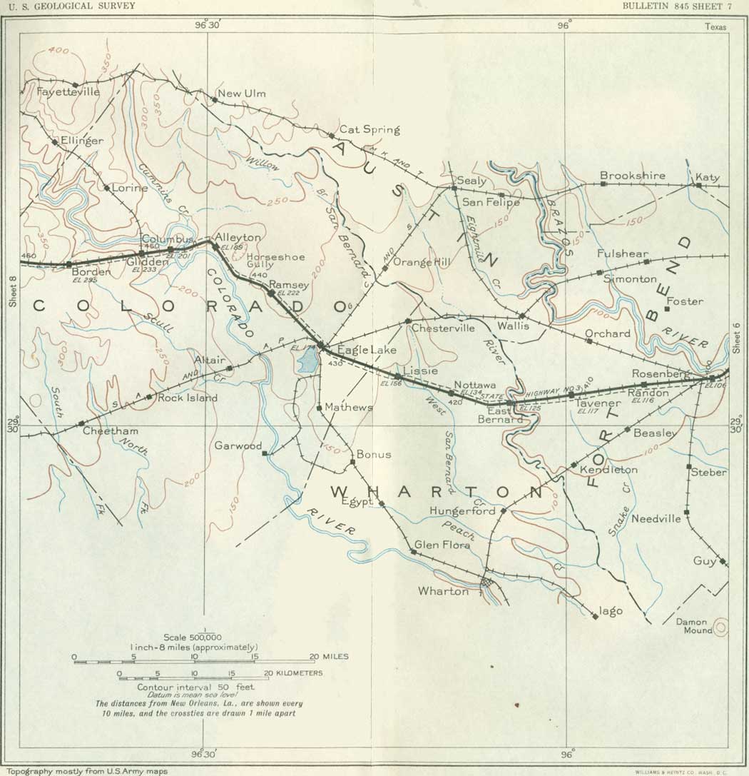
SHEET No. 7 (click in image for an enlargement in a new window) |
|
Rosenberg. Elevation 106 feet. Population 1,941. New Orleans 400 miles. |
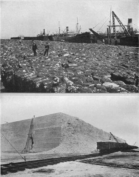
Rosenberg is a commercial center for a large farming and dairy district and the junction of several branch railroads. Twenty miles south-southwest of Rosenberg is the Boling salt dome, a large uplift which has yielded some oil and contains an enormous body of sulphur.32 The town of New Gulf (population 1,700*) has been established here, and the sulphur is being melted by steam and pumped up to the surface by the Frasch process. (See p. 32.) The deposit lies at depths of 450 to 1,200 feet and is believed to contain from 50,000,000 to 60,000,000 tons of sulphur. Two huge sulphur blocks have been made, each 600 feet long, 200 feet wide, and 40 feet high, as shown in Plate 6, B, and a still larger one is in progress. The material is about 99 per cent pure. The investment at this place is said to be $14,000,000. The production in 1930, according to the United States Bureau of Mines, was about 750,000 long tons, shipped largely to Galveston for water transportation.
32About 58 miles to the south there is another large sulphur mine at Big Hill (Gulf), which has been producing since 1919, and other deposits occur at Hoskin Mound, Bryan Heights, and Longpoint. The Boling oil field produced 378,000 barrels a day in 1930, the amount having been gradually diminishing since 1926. The first sulphur mined in Texas was obtained at Bryan Mound in 1913; now Texas produces 97 per cent of the output of the United States and 85 per cent or more of the world's output.
|
|
PLATE 6.—A (top), COTTON READY FOR SHIPMENT, GALVESTON, TEX.
19,000 bales. B (bottom), BLOCK OF SULPHUR AT NEW GULF, TEX. Ready to be broken up for shipment. |
Damon Mound, 20 miles south of Rosenberg, is a prominent feature in the flat lowlands, above which it rises 83 feet to an elevation of 140 feet. It is due to a typical salt dome in which a steep-sided plug of almost pure rock salt is capped by gypsum, anhydrite, and limestone. The salt mass penetrates and uplifts Tertiary formations, which dip away on all sides at steep angles. As in many other salt domes, the uplifted strata contained petroleum, most of it here being in sandstone and limestone of Oligocene(?) age. Up to 1924 the production was more than 5,000,000 barrels from 85 wells, and in 1930 the yield was 224,000 barrels. About the mound and penetrated by shallow wells are red, blue, brown, and yellow clays of the Beaumont formation, apparently deposited around the uplift. The salt core, which is of great but unknown thickness, comes within about 500 feet of the surface under the heavy cap rock, which is present in all domes. It is estimated to contain more than 1,000,000,000 tons of salt (Bevier). Damon Mound was an important headquarters for the Karankawan Indians, as shown by the presence of many fragments of pottery, burial grounds, stone implements, and arrowheads. The Indians regarded the "sour earth" of the mound as good medicine, and it had a favorable reputation over a wide area. This sour earth is due to the seepage of mineral solutions, which are usually present about a salt mound.
The geology of eastern Texas is not very impressive to the observer traveling by train until the Colorado River is crossed and the regular succession of Tertiary and Cretaceous strata comes to the surface. Roemer, the pioneer geologist of Texas, writing in 1846, when San Antonio was the frontier, said, "It is only where civilization ceases and the wilderness commences that the geological relations of the country begin to be interesting." Of the region around Columbus, Gonzales and Seguin, he remarked, "You see no solid rock in place excepting irregular layers of a coarse calcareous sandstone * * * exposed on the steep banks of some of the river; * * * the surface is covered with loose materials." However, later studies have brought to light in this region the following very interesting succession:
Formations of east-central Texas exposed near the
Southern Pacific lines
[Most of the information regarding the Tertiary
formations has been supplied by Julia Gardner]
| Age | Group | Formation | Principal materials | |
| Quaternary. | Alluvium and terrace deposits. | Gravel, sand, and loam. Nonmarine. | ||
| Pleistocene and Pliocene(?). | Lissie and Reynosa formations. | Gravel, sand, and clay. Nonmarine. | ||
| Pliocene. | Lagarto clay. | Massive green, gray, and brown clays stained purple and toward the top with abundant calcareous nodules and a few thin sandstones. Nonmarine. | ||
| Miocene. | Oakville sandstone. | Massive, in part cross-bedded yellowish or grayish indurated sandstones and brown calcareous clays. Nonmarine. | ||
| Catahoula sandstone. | Light-colored sands and loosely indurated sandstones and clays, many of them ashy. Mostly nonmarine. | |||
| Eocene. | Jackson. | Fayette sandstone. | Thin-bedded light-gray pepper and salt sandstone with interstratified leaf-bearing clays and thin beds of volcanic ash. Mostly nonmarine. | |
| Clairborne. | Yegua ("Cockfield") formation. | Dark-brownish, gray, and greenish-gray clays and clayey sands, many of them carbonaceous. Mostly nonmarine. | ||
| Cook Mountain formation. | Glauconitic fossiliferous sands and sandstones, marls, and clays. The basal member (Sparta sand) a loose or loosely indurated nonmarine sand. | |||
| Mount Selman formation. | Weches green-sand member. | Glauconitic and oolitic sandstones indurated with an iron cement; glauconitic clays; marine and sparsely fossiliferous. | ||
| Queen City sand. | Rather fine light-gray or iron-stained sands with thin interstratified light gray clays. Nonmarine. | |||
| Reklaw member. | Glauconitic fossiliferous sands and clays, in large part stained and indurated with iron oxide. | |||
| Carrizo sand. | Very coarse and pure quartz sand, loose or packed with little or no cementing material, Nonmarine. | |||
| Wilcox. | Indio formation. | Bedded yellowish-brown and red sands and sandstones and dark-colored clays, for the most part nonmarine, A few concretionary beds, the concretions carrying a few marine fossils. | ||
| Midway formation. | Dark-gray clay with concretion, and sandy clays; rarely a thin fossiliferous ferruginous sandstone near the top. | |||
The formations below the Lissie occur in widely extended sheets which dip at a low angle to the southeast. As the rate of dip is greater than the rise of the land, their outcropping edges come to the surface in regular succession to the west. This relation is shown in the cross section on sheet 8. They are conformable in attitude, but some of them are separated by unconformities.
Near Tavener a group of derricks off to the north marks the Orchard oil field, which has had a small production from a salt dome that was discovered by geophysical tests on the surface.
|
East Bernard. Elevation 125 feet. New Orleans 416 miles. |
Just east of East Bernard the San Bernard River33 is crossed in a valley about 30 feet deep, containing cypress, oak, and other trees of the lowland flora. Not far beyond the bridge the railroad deflects to the northwest across a broad plain that extends beyond Eagle Lake and is in large part occupied by rice fields.
33The banks on the east side of this valley expose gray sandy clays, regarded (by Deussen) as the basal member of the Beaumont clay, which are underlain by Lissie sand and gravel (not exposed here). At the top is reddish sandy clay, probably alluvium.
|
Eagle Lake. Elevation 174 feet. Population 2,343. New Orleans 432 miles. |
Eagle Lake is a shallow body of water lying in a depression due to an old bend of the former course of the Colorado River. It contains considerable water, especially after rains, and is used as a reservoir for water pumped from the river and then into a canal for irrigating rice fields to the east. On the east slope of the depression, a mile or more south of Eagle Lake town, are banks 10 to 20 feet high showing gravelly cross-bedded compact sand, regarded as Lissie. There are also cuts in this material near the railroad just west of the town.
At Eagle Lake the railroad deflects to a course nearly northwest and, passing over a low ridge at Ramsey siding (elevation 222 feet), descends into the broad terraced valley of the Colorado River. The formation covering this region in a widespread mantle is the Lissie gravel; distinctive outcrops are rare, and few are visible from the train. Three miles southwest of Eagle Lake is an artesian well 1,506 feet deep, which has an excellent flow of tepid sulphur water. Four miles northwest of Eagle Lake the Lissie gravel is exposed lying on clay and sand with gravel (mostly chert) which may represent a separate formation. In the banks of the Colorado River 5 miles southwest of Ramsey siding and again on the slope 4 miles northwest of that place the formation known as the Lagarto clay is revealed. It consists of sandstone, in part conglomeratic, with interbedded clay, and is part of the great eastward-dipping succession of formations of Tertiary and Cretaceous age which come to the surface in regular order as given in the table on page 50 and as shown in section on sheet 8.
In the region west of Eagle Lake much of the land is prairie with scattered clumps of timber, especially along the streams. Post oaks (Quercus stellata) are the most abundant trees and some of them reach a diameter of 2 feet and a height of 30 feet. Small hickories and live oaks (Quercus virginiana) are fairly common, and the yaupon or scrubby southern holly (Ilex vomitoria), hawthorn, buckthorn, and other small trees are widespread. Spanish moss festoons many of the trees in the lower lands, where also there are a few palmettos. Large sycamores, or buttonwoods (Platanus occidentalis), live oaks, white oaks, pecans, black walnuts, cedars, and soapberry trees are widely scattered. A few shortleaf pines occur, notably in a small clump 3-1/2 miles north of Alleyton. In the vicinity of Alleyton and Columbus cottonwood trees (Populus fremonti) appear along the larger water-courses, a feature which is characteristic in central and western Texas. There are also many willows in the lowlands, but cypress disappears. Yuccas begin, but they are not abundant.
|
Alleyton. Elevation 189 feet. Population 40.* New Orleans 445 miles. |
Near Alleyton there are deep gravel pits from which a large amount of material has been excavated for railroad ballast and road metal from an alluvial deposit of a terrace built by the Colorado River at a time geologically not very remote. The gravel pits are marked by great mounds of refuse stripping.
About 3 miles west of Alleyton the Colorado River is crossed; Columbus lies on its west bank. Near by at Beason's ford the Texans under General Houston camped for a while prior to their victorious battle at San Jacinto. The Colorado River rises in the central part of the State and empties into Matagorda Bay with a total length of about 715 miles. The name Colorado (Spanish, red) is appropriate, for when the river is in freshet the red beds which are traversed by its upper waters give it a large amount of red mud. About 75 miles above Columbus on this stream is Austin, the capital of Texas, founded in 1839 on 7,735 acres of land bought for this purpose by the Republic at a cost of $21,000.
|
Columbus. Elevation 201 feet. Population 2,054. New Orleans 448 miles. |
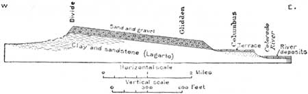
Columbus is a local business center for diversified farming interests, rice here giving place to a variety of crops and more extensive cattle raising and dairying. On the edge of the town is a flowing well of excellent water in small volume said to come from a depth of 1,400 feet. In the west bank of the river half a mile below the railroad bridge are conspicuous ledges of moderately compact gray sandstone overlain by softer gray sandstone, all of the Lagarto formation,34 capped by a sheet of alluvium which constitutes the terrace on which Columbus is built. This terrace extends west a short distance and abuts against or gives place to an upland of eastward-dipping reddish beds that contain much gravel and are regarded as the Lissie formation. These beds are well exposed in the railroad cut through the divide 2 miles west of Glidden. The Lagarto-Lissie contact makes a strong reentrant down the Colorado River Valley, and the railroad skirts this contact to a point about 4 miles west of Glidden before finally entering the Lagarto, which it crosses at an angle of about 120° to the strike. (See fig. 4.) From Glidden a branch railroad extends to Lagrange, on the Colorado River.
34The Lagarto formation is largely a calcareous clay with a few soft, thin, irregularly bedded light-colored sandstones loosely held together by a calcareous cement. The clays are unstratified, plastic, and usually jointed, and their cleavage surfaces are stained with manganese oxide. They are commonly mottled in pastel tints of green, gray, and brown and near the top, where they are possibly stained by the iron oxide leached from the Lissie, in pastel purples and reds. Calcareous nodules are abundant in places. Limy conglomerate and limestone near the top may represent the overlying Reynosa formation. A few vertebrate remains, mostly of horses, and chara stems, together with reworked Cretaceous fossils, locally abundant, have been found in the Lagarto beds and in the deep wells near the Gulf a marine micro-fauna indicating a shore line slightly inland from the present coast. The formation is about 1,200 feet thick, and it dips to the southeast about 50 feet to the mile.
|
| FIGURE 4.—Section along the southern Pacific Railroad through Columbus and Glidden, Tex. |
The clays and soft sandstone of the Lagarto formation extend west to and beyond Schulenburg. The outcrop zone of the Lagarto strata is mostly a rolling, treeless prairie of black calcareous clay, very heavy when wet, or, in the area of outcrop of the less argillaceous beds, a sandy loamy soil. Near the eastern contact post oaks and live oaks indicate that the higher elevations are capped with Lissie gravel. (Turn to sheet 8.)
| <<< Previous | <<< Contents >>> | Next >>> |
bul/845/sec7.htm
Last Updated: 16-Apr-2007