|
Geological Survey Circular 1085
Our Changing Landscape: Indiana Dunes National Lakeshore |

(Gil Fraga)
CONTAMINATION
Contamination of our environment is becoming an increasing threat. We worry about the quality of the air we breathe and the water we drink; the quality of each is threatened by a multitude of activities. Factories discharge airborne pollutants through their smokestacks; pesticides become airborne during application. Almost any activity above or below the land surface has the potential for contaminating soil or water. Although some sources of contamination are natural, contamination generally is a result of human activity.
Examples of sources of environmental contamination include:
- salt stockpiles
- urban runoff
- sewage overflows
- slag piles
- wastewater ponds or lagoons
- wastewater injection wells
- landfills
- salvage yards
- septic systems
- drain cleaners or other household chemicals
- motor oil
- fertilizers or pesticides
- animal feedlots and stockyards
- automobile exhaust

|
| Airborne particles can originate from natural sources such as volcanic eruptions. These eruptions can release large quantities of ash, gases, and aerosols, which can circle the globe in the stratosphere. |

|
| Industrial fires, such as this storage tank fire in Houston, Tex., can introduce contaminants into the atmosphere. (Leo Childs) |
Often, we do not realize that a contamination problem exists until it is too late. In air and surface-water resources, it is likely that we can see the contamination. With our ground-water resources, however, the flow of water occurs below the land surface, and problems go undetected until that water reaches the surface—either naturally (as discharge to a lake, river, stream, or wetland) or artificially (as discharge from a well).
Water is constantly moving through the global hydrologic cycle, which includes water as precipitation and snowmelt. Water moves on the land surface toward lakes, rivers, streams, and wetlands (runoff) or goes into the ground (infiltrates) to become ground water. Ground water moves much more slowly than surface water does. Ground water moves through aquifers (water-bearing sediments) toward lakes, rivers, streams, and wetlands. Ground water can flow toward deeper aquifers and ultimately flow to the ocean. Evaporation of surface water and water returned to the atmosphere by plants (transpiration) provide the atmospheric moisture for rain or snow and complete the flow of water through the hydrologic cycle.

|
| Water is constantly moving through the hydrologic cycle. |
If water becomes contaminated as it moves through the hydrologic cycle, the path it takes can determine the degree to which it is contaminated and the time it will take to be cleansed. One concern with ground-water contamination is the very slow flow rate. Whereas surface-water flow rates are commonly measured in feet per minute, ground-water flow rates are commonly measured in feet per year. These slow rates of movement become significant when we are waiting for an aquifer to naturally flush out contaminants, or purge itself. It is not uncommon for a contaminated aquifer to take decades to clean out. Prevention of ground water contamination in the first place is preferable to cleaning up ground-water resources after they have been contaminated.
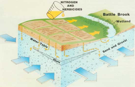
Activities that take place at the land surface in one location can affect water-quality conditions over a much larger area. Homeowners who apply fertilizers or pesticides to their lawns incorrectly can contaminate ground water easily, which can flow to their wells or to neighbors' wells. A landfill at the edge of a town can contaminate ground water flowing to an adjacent town's well field; agricultural application of pesticides in one State can easily contaminate ground water or surface water in an adjacent State.

|
| Fertilizers and pesticides can be sources of water and air contamination. |
Scientific information pertaining to the hydrologic cycle and the stresses on the cycle plays a critical role in the management of our water resources at local, regional, national, and global scales. For example, scientific information is needed to quantify the potential effect of contamination, to document areas where air or water resources have been contaminated, and to predict recovery times for the contaminated areas.
Although the potential sources of contamination mentioned previously are national issues, their presence at Indiana Dunes has also made them regional issues. As indicated in the "Land Use" section of this report, the southern shore of Lake Michigan is one of the largest industrial centers in the Nation and is a major transportation corridor for the Midwest. Agricultural land, which has a contamination potential from fertilizer and pesticide use, is being converted to suburban or urban land, which has a different contamination potential (septic systems and urban runoff).

|
| The ground water in Indiana Dunes is vulnerable to contamination from industrial landfills and other sources. (Bob Daum) |
Indiana Dunes National Lakeshore lies east of and within a vast urban and industrial complex. The park also contains "islands" of industrialization within its boundaries. Indiana Dunes, located within the "prevailing westerlies"—a region of the country where winds blow primarily from the west—is essentially downwind from Chicago and Gary and receives airborne contamination from these sources. Airborne particles containing heavy metals enter lakes, streams, rivers, or wetlands by falling with rain or snow. In order to estimate historical air contamination, park scientists collected cores of peat from Cowles Bog. Cowles Bog was selected for study because it is not fed primarily by streams; thus, any metals detected in the core could be attributed to airborne contaminants. It was concluded from the study of the cores that, as industrialization occurred upwind from the park, the deposition of contaminants rose dramatically in relation to presettlement levels. The first rise in metal accumulation above presettlement levels (1850-90) is probably related to coal burning on steam locomotives, residential fires, and rapid growth of the iron and steel industry. Continued growth of the iron and steel factories during this century and operation of coal-fired powerplants brought increased metal accumulations. The parts of the cores that represent the years postdating 1978 contain lower metal concentrations, perhaps because of a reduction in steel production or an increase in emission controls.

|
| Diagram showing some of the effects of agricultural land use on the quality of soil and water. Large arrows show the direction of ground-water flow. |

|
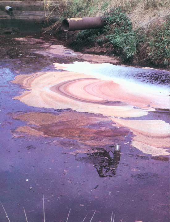
| Industrialization is important to our Nation's well being but causes air and water contamination if preventive measures are not used. (Gary North) |
Other air pollutants, including ozone and various sulfur compounds, have been shown to be toxic to selected plants. Effects on growth and reproduction, particularly of the white pine, have been documented through studies of tree rings. Lichens in Indiana Dunes have decreased in number by about 90 percent since the turn of the century.

|
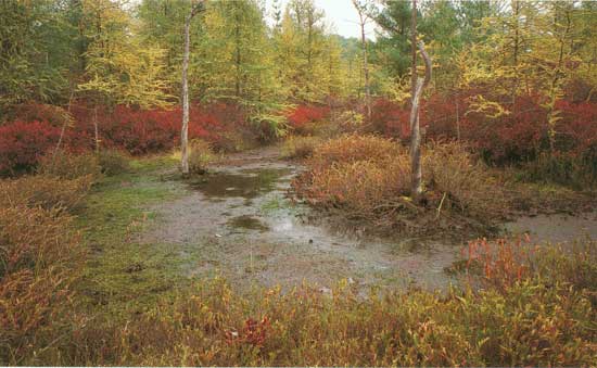
| Bogs can be affected by contaminants that are transported by air or water. As an example, highway deicing salts stored nearby had an adverse effect upon the plants in Pinhook Bog. (Bob Daum) |
Other changes in vegetation may be caused by acid precipitation. The pH of rainfall at Indiana Dunes is 4.5, which is approximately 15 times more acidic than uncontaminated rainfall, which has a pH of 5.7.
Water quality has also been adversely impacted at Indiana Dunes. Neighboring industrial, agricultural, and residential activities all present water-quality hazards. Major water-quality concerns at Indiana Dunes include bacterial contamination at swimming beaches, road-salt contamination, parking lot and highway runoff, industrial landfill contamination, seepage into the Little Calumet River and drainage ditches from sewage systems, industrial outflows, treatment ponds, and agricultural runoff. Heavy metals and high levels of nitrates and PCB's (polychlorinated biphenyls) have been found in surface water and in ground water. High bacterial levels, a danger to human health, have resulted in the closing of some beach areas and placed some restrictions on use of the Little Calumet River. Pinhook Bog was severely affected by highway deicing salts until the salt, which was stored nearby, was removed.
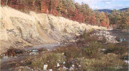
Another water-quality concern is litter, trash, and general dumping. Hazardous materials dumped with trash or spilled during accidents pose a threat to water quality.

|
| General dumping poses a threat to water quality. (William Davis) |
| <<< Previous | <<< Contents >>> | Next >>> |
circ/1085/sec6.htm
Last Updated: 27-Apr-2009