
|
Geological Survey Circular 838
Guides to Some Volcanic Terrances in Washington, Idaho, Oregon, and Northern California |
ROADLOG FOR GEOLOGIC FIELD TRIP BETWEEN LEWISTON, IDAHO AND KIMBERLY, OREGON
D.A. Swanson, U.S. Geological Survey, Menlo
Park, CA 94025
and
T.L. Wright, U.S. Geological Survey, Reston, VA
22092
| MILES | |||
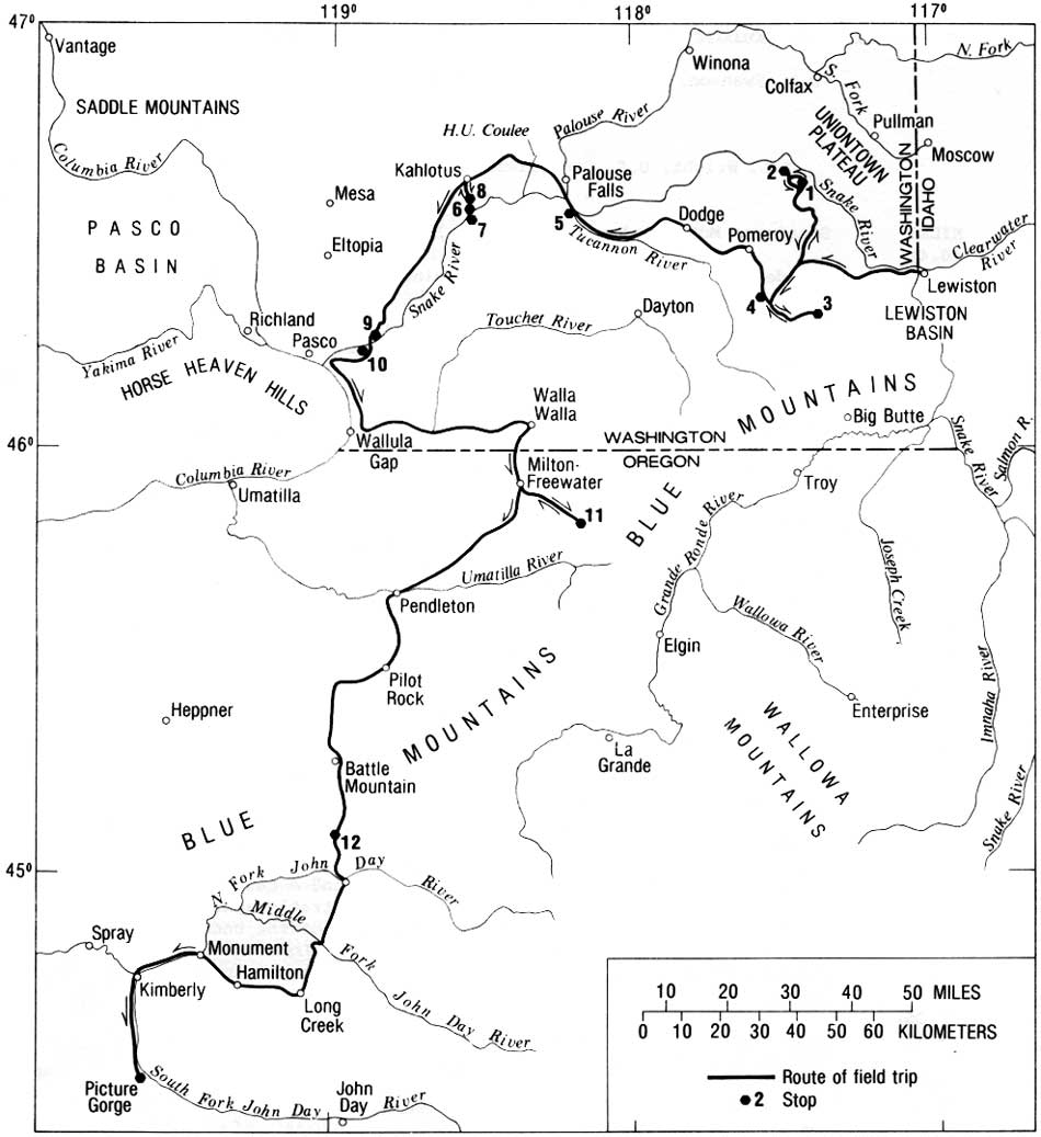
| Sacajawea Motor Lodge in Lewiston, Idaho (fig. 7). Drive west. | |||
| (0.4) | |||
| 0.4 | Tapadera Inn. Continue west, following signs to U.S. 12. | ||
| (0.95) | |||
| 1.35 | Turn left to west U.S. 12. | ||
| (0.2) | |||
| 1.55 | Cross Snake River. Enter Clarkston, Washington. The Snake here is now a lake, impounded behind the recently completed Lower Granite Dam. | ||
| (0.2) | |||
| 1.75 | Continue straight ahead on U.S. 12 toward Pomeroy and Walla Walla. | ||
| (1.7) | |||
| 3.45 | At 12:00, the Pomona Member of the Saddle Mountains Basalt fills ancient canyon of Snake River eroded into flows of the Grande Ronde Basalt (R2 magnetostratigraphic unit). | ||
| (0.55) | |||
| 4.0 | At 11:00, house on bluff rests on Lower Monumental Member, which was confined to an old Snake River canyon carved deeply into the older flows between about 10.5 and 6 m.y. ago. | ||
| (0.95) | |||
| 4.95 | Roadcuts in Grande Ronde Basalt for several miles. | ||
| (1.1) | |||
| 6.05 | On left, colonnade of the canyon-filling Pomona Member. Note underlying white ash, a probable correlative of which occurs near Ice Harbor Dam (stop 9). | ||
| (0.95) | |||
| 7.0 | At 1:00, steeply dipping flatirons of the Grande
Ronde Basalt near core of the Gaging Station anticline. This route passes through the Lewiston Basin, a structurally complex area recently studied by Camp (1976). Flows at or near river level along the road also occur near the top of the escarpment north of the river. A major fault follows the west-flowing river, and a faulted anticline north of the river exposes the lower three magnetostratigraphic units of the Grande Ronde Basalt as well as the upper part of the underlying Imnaha Basalt. The latest tectonism occurred in post-Lower Monumental time, as canyon-filling remnants of this 6 m.y. member have been deformed (Camp, 1976). | ||
| (2.55) | |||
| 9.55 | Quarry on left in the Pomona Member. Good example of colonnade and entablature jointing habits, generally well developed in intracanyon flows. | ||
| (0.55) | |||
| 10.1 | Look back at 4:00-5:00 and see the Gaging Station anticline in core of Lewiston Basin structure. | ||
| (0.1) | |||
| 10.2 | Bluff on left is the Lower Monumental Member. At 2:00, view down Snake River of the Grande Ronde Basalt. | ||
| (0.3) | |||
| 10.5 | Road leaves Snake River and follows Alpowa Creek. | ||
| (2.3) | |||
| 12.8 | Road crosses approximate axis of Gaging Station anticline, rapidly dying out west of the Lewiston Basin. | ||
| |||
| (1.3) | |||
| 14.1 | Note sign on left commemorating passage of Lewis and Clark on their return trip. | ||
| (1.9) | |||
| 16.0 | Intersection with Clayton Gulch road. Continue on U.S. 12. | ||
| (1.25) | |||
| 17.25 | Intersection with Howell Grade road. From here, U.S. 12 passes upsection across the upper two magnetostratigraphic units of the Grande Ronde Basalt capped by the Roza Member of the Wanapum Basalt near Alpowa Summit. An unknown but observant geologist-polluter painted yellow letters on each flow in the section, with L the oldest and E (Roza Member) the youngest. The dip of the section is only slightly less than the gradient of the road. | ||
| (0.7) | |||
| 17.95 | Base of flow L. R2. | ||
| (1.55) | |||
| 19.5 | Base of flow K. R2. | ||
| (0.55) | |||
| 20.05 | Base of flow J. N2. | ||
| (0.45) | |||
| 20.5 | Base of flow I. N2. | ||
| (0.35) | |||
| 20.85 | Base of flow H. N2. | ||
| (0.2) | |||
| 21.05 | Base of flow G. N2. | ||
| (0.3) | |||
| 21.35 | Base of flow F. N2. | ||
| (0.15) | |||
| 21.5 | Roadcut on left shows thick ancient soil (saprolite) developed on flow F. This saprolite, marking the top of the Grande Ronde Basalt, is overlain by the Roza Member. | ||
| (0.15) | |||
| 21.65 | Flow E (Roza Member) exposed from here to summit. | ||
| (1.25) | |||
| 22.9 | Alpowa Summit, elevation = 2785 ft. | ||
| (0.3) | |||
| 23.2 | Intersection with Ledgerwood Road, Turn right. | ||
| (1.5) | |||
| 24.7 | Small outcrop of Roza spatter on right (near-vent locality 13 in Swanson and others, 1975, table 1). | ||
| (0.8) | |||
| 25.5 | Junction with Kirby-Mayview Road. Continue straight (northward) on pavement. | ||
| (0.85) | |||
| 26.35 | Junction with Valentine Ridge Road. Continue straight. Valentine Ridge Road leads to stop 18 of Swanson and Wright (1967a), an interesting vent area for a flow in the Grande Ronde Basalt. | ||
| (1.55) | |||
| 27.9 | Roadcut just beyond junction with Connell Hill Road. Thin flows of the Roza Member, with little or no spatter. Experience shows that, in this area, much thin flows are likely to be near a vent. Continue on Kirby-Mayview Road. | ||
| (5.45) | |||
| 33.35 | Intersection with Tramway Road. Turn right toward Tramway. | ||
| (4.05) | |||
| 37.4 | Cliffs ahead expose a flow of Lolo chemical type in the Priest Rapids Member of the Wanapum Basalt. | ||
| (0.4) | |||
| 37.8 | Stop at white stile. STOP NO. 1. Gracefully cross stile and walk to lip of Snake River canyon for view of Grande Ronde flows and discussion of stratigraphy and mapping methods. Quarry is in a flow of Lolo chemical type in the Priest Rapids Member. | ||
| (0.45) | |||
| 38.25 | Continue north on Tramway Road. Keep left at intersection with East Wawawai Grade road. | ||
| (0.9) | |||
| 39.15 | Junction with Kirby-Mayview Road. Turn right. | ||
| (0.1) | |||
| 39.25 | Junction with Wawawai Grade Road. Continue on pavement. | ||
| (2.1) | |||
| 41.35 | Mayview. Continue straight. | ||
| (0.6) | |||
| 41.95 | Roadcut exposing two thin flows of the Roza Member separated by welded spatter. Continue ahead. | ||
| (0.55) | |||
| 42.5 | STOP NO. 2. Bus lets passengers off here and proceeds
for 1.3 miles, turns around, and waits for passengers, who walk down
road. Roadcuts show the Roza Member overlying thin, discontinuous silt
resting on the sparsely plagioclase-phyric Frenchman Springs Member
(2 flows). A thin saprolite and detrital(?) clay separate the Frenchman
Springs from the Grande Ronde Basalt. The Frenchman Springs thickens
west from here to 150 m in Devils Canyon (Stop 6); it does not occur
farther east. Eastward thinning of the Frenchman Springs Member is
typical throughout southeast Washington and northeast Oregon and is
interpreted to mean that the flows pinched out against a gentle westward
slope. All known feeder dikes for the Frenchman Springs Member occur in
the central part of the plateau; we will see some unusual examples
tomorrow. The flows of the Grande Ronde Basalt, all in the N2 magnetostratigraphic unit, display a variety of primary structures, such as joints and rubbly tops. Many flows are thin and may have erupted locally. One thick and two thin feeder dikes for the Roza Member are exposed. Perhaps the spatter at mileage 41.95 was erupted from this dike. This location is along the axis of the Roza vent system. One of the vent areas will be viewed at the next stop. Return to U.S. 12 via Kirby-Mayview, Ledgerwood, and Ledgerwood Spur Roads. | ||
| (5.9) | |||
| 48.4 | Junction with Tramway Road. Keep right, on pavement. | ||
| (3.35) | |||
| 51.75 | Junction with North Deadman Creek road, turn right, staying on Kirby-Mayview Road. | ||
| (4.1) | |||
| 55.85 | Junction with Tramway Road. Continue straight. | ||
| (7.9) | |||
| 63.75 | Junction with Ledgerwood Road. Turn left, leaving pavement. | ||
| (0.15) | |||
| 65.9 | Junction with U.S. 12. Cross highway, continuing on Sweeney Gulch Road. | ||
| (8.4) | |||
| 74.3 | Junction with State Highway 128. Continue straight, up a gentle dipslope related to the Blue Mountains uplift farther south. | ||
| (2.65) | |||
| 76.95 | Road intersection. Continue straight on 128. | ||
| (2.3) | |||
| 79.25 | Metropolis of Peola. Bear left on main road, avoiding road to Cold Springs. | ||
| (2.85) | |||
| 82.1 | Continue east on Highway 128. | ||
| (1.1) | |||
| 83.2 | Asotin-Garfield County Line. | ||
| (2.3) | |||
| 85.5 | At 4:00, good view of dip slopes on north flank of Blue Mountains. Potter Hill ahead. | ||
| (1.1) | |||
| 86.6 | STOP NO. 3. Potter Hill vent area for Roza Member. Note pumice,
welded spatter, dikes, and primary dips related to cane. The Roza Member
vent system is more than 165 km long and less than 15 km (probably less
than 5 km) wide. The vent system is defined by dikes, such as those at
stop 2, and vent areas such as this one. Big Butte, visible from here to
south, is another vent area from which one of the latest eruptions took
place. Turn around, and retrace route to Sweeney Gulch Road. | ||
| (12.35) | |||
| 98.95 | Junction with Sweeney Gulch Road. Bear left, staying on Highway 128. | ||
| (0.1) | |||
| 99.05 | Roadcut exposing a Dodge flow in the Eckler Mountain Member of the Wanapum Basalt. | ||
| (0.15) | |||
| 99.2 | Base of Dodge over red saprolite developed on Grande Ronde Basalt. Road cuts beyond expose flows in uppermost magnetostratigraphic unit (N2) of the Grande Ronde. | ||
| (1.25) | |||
| 100.45 | Cross Pataha Creek at Columbia Center. Keep right across bridge. | ||
| (0.9) | |||
| 101.35 | STOP NO. 4. Roadcut shows the basalt of Dodge overlain by dense aphyric flows of the Frenchman Springs Member. Walk back along road 30 m to see saprolite under Dodge. The basalt of Dodge is in places interleaved with saprolite, showing that it was erupted during the time of regional soil formation on the Grande Ronde Basalt. Note the coarse grain size, large plagioclase phenocrysts, and grusy nature of the Dodge, which make it a fine marker in the field. | ||
| (0.6) | |||
| 101.95 | Turn right on pavement and continue down approximate dip slope on the Roza Member. | ||
| (4.05) | |||
| 106.0 | Dirt road to right. Start of Benjamin Gulch section. This section, capped by the Roza Member, exposes interbedded flows of Grande Ronde, Dodge, and dominantly Frenchman Springs chemical types, and is the only such section known in Washington. This section is of great importance, as it demonstrates that eruptions of greatly different magma chemistries overlapped in time. Presumably this locality contains flows erupted throughout the time interval during which a soil was forming elsewhere in southeast Washington. | ||
| (0.65) | |||
| 106.65 | Quarry in dense flow of the Frenchman Springs Member as at Stop 4. | ||
| (0.1) | |||
| 106.75 | The basalt of Dodge under the Frenchman Springs Member. Next few cuts reveal interlayering; exposures are good but not eyecatching, All contacts are exposed. | ||
| (1.25) | |||
| 108.0 | Approximate base of section. | ||
| (1.5) | |||
| 109.5 | Pomeroy town limit. | ||
| (0.4) | |||
| 109.9 | Intersection with U.S. 12. Turn left (west) on highway. | ||
| (6.0) | |||
| 115.9 | Junction with State Highway 126. Continue ahead on U.S. 12. For the next few miles, a ledge-forming flow is quite prominent, particularly in about 3.5 miles. This flow, informally called the Pataha flow, is of high-Mg Grande Ronde chemical type and is near the top of the Grande Ronde section in this area. | ||
| (7.2) | |||
| 123.1 | Junction with State Highway 127. Continue left (west) on U.S. 12, toward Walla Walla. Type locality of the basalt of Dodge is in roadcuts along S.H. 127, 0.95 miles northeast of junction. | ||
| (8.45) | |||
| 131.55 | Junction with State Highway 261. Turn right toward Palouse Falls State Park. Roadcuts in next few miles expose flows in N2 part of Grande Ronde Basalt. Road follows the Tucannon River. | ||
| (6.85) | |||
| 138.4 | Junction with paved road to Little Goose Dam. Stay left, in valley. Road to dam is access to Stops 10-14 of Swanson and Wright (1976a), For next mile, black cliff above road is in the Lower Monumental Member of the Saddle Mountains Basalt, which occupies a broad valley eroded through the Wanapum Basalt into the Grande Ronde Basalt at the confluence of the Snake and Tucannon Rivers. Exposures of the Pomona Member in a canyon-filling relation occur nearby. | ||
| (3.3) | |||
| 141.7 | Good exposures of tiered flow of the Grande Ronde Basalt. White ash in pockets on hillside is Mazama ash. | ||
| (0.3) | |||
| 142.0 | STOP NO. 5 (optional). Origin of tiered flows. Are tiers the result of some process completely internal to a ponded flow and related to its cooling history, or does each tier record a separate pulse of lava into a gradually deepening pond? In other words, is a tiered flow a single or multiple-flow cooling unit? Good exposures of vesicular layers defining boundaries of tiers are found above the railroad tracks to left of road. | ||
| (1.4) | |||
| 143.4 | Dark mesas to left are remnants of the Lower Monumental Member resting erosionally on the Frenchman Springs Member. Intracanyon remnants of the Pomona and Esquatzel also occur near here. The prominent bench seen above both the Palouse and Snake Rivers is along the contact of the Grande Ronde and Wanapum Basalts. Cross Snake River near mouth of Palouse River. The renowned archeologic site, Marines Rock Shelter, is drowned beneath lake waters just up the Palouse. | ||
| (1.65) | |||
| 145.05 | Entrance to Lyons Ferry State Park. Continue straight. | ||
| (1.1) | |||
| 146.15 | Poorly exposed contact of the Grande Ronde Basalt and the Frenchman Springs Member of Wanapum Basalt. | ||
| (1.3) | |||
| 147.45 | Base of the Roza Member. | ||
| (2.4) | |||
| 149.85 | Junction with road to right to Palouse Falls State Park. Continue straight ahead. The junction is just below the contact of the Priest Rapids and Roza Members. The road to the park crosses the Roza and the Frenchman Springs Members. The lip of the falls is carved into the oldest flow of the Frenchman Springs. | ||
| (2.2) | |||
| 152.05 | Flow of Lolo chemical type in the Priest Rapids Member crops out just above road; it is the youngest flow throughout the area. Good example of scabland topography (Scablandia) to east (right). Begin to cross upper reaches of H.U. Coulee; roadcuts expose the Roza and Frenchman Springs Members. | ||
| (2.2) | |||
| 154.25 | View to left down H.U. Coulee. a scabland channel made famous by J. Harlan Bretz. Roadcuts beyond are the Roza and Frenchman Springs Members. | ||
| (4.4) | |||
| 158.65 | Junction with Highway 260. Turn left toward Pasco.
Highway follows dry Washtucna Coulee, former course of
Palouse River. Erosion caused by catastrophic flooding (the Spokane
floods) in the late Pleistocene diverted the river from its former
course into a more direct link with the Snake River via Palouse Falls.
Prior to the floods, the Palouse flowed down Washtucna Coulee to Connell
and then south-southwestward to the Pasco area via Esquatzel
Coulee. The highest continuous ledge along the coulee walls between here and Kahlotus is the Roza Member; the highest discontinuous exposures are of the Priest Rapids Member. | ||
| (2.85) | |||
| 161.5 | View to right of gravel bar deposited by Spokane floods. | ||
| (5.2) | |||
| 166.7 | Junction in Kahlotus with paved road to Pasco and Lower Monumental Dam. Turn left. | ||
| (0.7) | |||
| 167.4 | Junction with road to Lower Monumental Dam. Turn left down Devils Canyon. All roadcuts expose flows of the Frenchman Springs Member, totalling about 150 m thick. Contrast with the 20 m of the Frenchman Springs seen at stop 2. | ||
| (4.55) | |||
| 171.95 | Look ahead at remnant of the Lower Monumental Member forming cliff overlying river gravel across river beyond dam. | ||
| (0.65) | |||
| 172.6 | Large parking area to right opposite turn toward dam, STOP NO. 6. Contact of the Frenchman Springs Member of the Wanapum Basalt and Grande Ronde Basalt. Lowest exposed flow is the Grande Ronde. It has an oxidized top and is overlain by a Frenchman Springs flow with sparse, small plagioclase phenocrysts. The oxidized zone is an incipient residual soil horizon. Traced eastward, this zone gradually thickens into a true saprolite, which is well exposed at stops 2 and 4. As the soil zone thickens, the overlying Frenchman Springs thins and finally dies out, leaving the Roza Member resting directly on saprolite. This is evidence that the Frenchman Springs flows were erupted in a basin, presumably created by earlier subsidence or westward tilting of the Columbia Plateau. STOP NO. 7. (Optional) From stop 6, drive across Lower Monumental Dam and park along road 1 mile beyond southeast end of dam, at base of the flow defining the Lower Monumental Member. This flow, at 6 m.y. the youngest flow in the Columbia River Basalt Group, extends at least as far east as Asotin, Washington, The Lower Monumental has not been recognized farther west than its type locality. The flow overlies river gravel consisting of basalt, metavolcanic rocks, and a very few plutonic rocks with lenses of quartz-feldspar-muscovite sand. This assemblage is clearly that of an ancestral Snake River, not a small stream heading on the plateau itself. | ||
| (0.65) | |||
| 173.25 | Retrace route from stop 6. Looking up Devils Canyon from this point, a good cross-sectional view of flows filling a steep-walled gorge is exposed on the northeast wall of the canyon. | ||
| (1.5) | |||
| 174.75 | Park in small turnout on right. STOP NO. 8. Intracanyon flows. Before Lower Monumental time, the ancestral Snake River apparently occupied a gorge 2-3 km north of the present canyon. Four different lava flows poured down this gorge, with renewed canyon cutting between each eruption, resulting in the compound lava fill exposed in cross section in the cliffs on either side of the road. East of the road, a "triple junction" is well exposed. Here the 12 m.y. Pomona Member (right) filled an almost vertically walled gorge cut into the oldest known intracanyon flow in this area, about 12.5 m.y. (left). Note the nearly horizontal columnar jointing in the Pomona along the contact. After a period of erosion, which beveled the Pomona and older intracanyon flow, the 10.5 m y. Elephant Mountain Member was erupted. It forms the uppermost flow in contact with both of these older intracanyon flows. West of the road, relations are more involved. Four flows are present here, and they meet at a common point above the railroad grade, The same three flows in the cliff east of the road are also here, with a fourth, the Esquatzel Member, between the unnamed intracanyon flow and the Pomona. Eastward from a point 8 km east of Devils Canyon, the pre-Lower Monumental canyon of the Snake follows the present canyon rather closely. West of there, however, the older canyon continued due west, meeting Esquatzel Coulee between Mesa and Connell. The course of this old canyon can be traced using detailed aeromagnetic data (Swanson and others, 1979c), as the thick intracanyon flows of uniform polarity exhibit narrow, sinuous anomalies of greater amplitude than the thin, normal and reversed flows forming the wallrock. We can speculate that the Elephant Mountain flow so thoroughly choked the canyon that the Snake spilled southward over a divide, located about 8 km east of Devils Canyon near Magallon ranch, into a tributary of the ancestral Columbia River leading southwest toward Pasco. Erosion of this divide proceeded comparatively rapidly, and the Snake has remained in this canyon since then. | ||
| (3.05) | |||
| 177.8 | Continue up Devils Canyon. Turn left at intersection, toward Pasco. Roadcuts in the Roza Member. Contact with the Priest Rapids exposed in highest cut. | ||
| (9.3) | |||
| 187.1 | Continue straight at junction with Wallace Walker road. | ||
| (0.75) | |||
| 187.85 | Outcrop of the Priest Rapids Member below the Elephant Mountain Member in gully to right. | ||
| (9.4) | |||
| 197.25 | Continue straight at intersection with Burr Canyon road. A feeder dike for a flow of the Frenchman Springs Member can be reached by following the Burr Canyon road to the lowest railroad right-of-way shown on the Lower Monumental Dam 7-1/2' quadrangle. The tracks have been removed from this right-of-way, and the route was drivable with care in 1977. From Burr Canyon, follow the abandoned railroad about 2.5 miles to near Abe triangulation station (Elwood 7-1/2' quad). Several small faults offset the red, oxidized contact of the Grande Ronde Basalt and Frenchman Springs Member exposed along the way. The widest plagioclase-phyric dike, evident in cuts, projects across the river and feeds the prominent flow exposed at top of dike. By climbing up hill (poor exposure) above Abe, the top of the dike can be seen in cuts along the relocated railroad. A shallow pool of columnar basalt fills the flared top of dike and merges laterally into an extensive porphyritic flow. | ||
| (0.65) | |||
| 197.9 | Ghostly sand dunes to right, | ||
| (10.65) | |||
| 208.55 | Leave loess hills and enter onto dip slope developed in the Elephant Mountain Member. Spokane floods stripped away the loess. | ||
| (5.05) | |||
| 213.6 | Junction with road to Ice Harbor Dam. Turn left (south). | ||
| (2.75) | |||
| 216.35 | Turn left, onto another paved road, just before dam. Sign points to Boat Landing. | ||
| (0.3) | |||
| 216.65 | Junction with gravel road. Keep left on gravel road across wooden plank bridge. | ||
| (0.4) | |||
| 217.05 | Junction of track roads. Both lead to same place, Righthand route was best in 1979. | ||
| (0.2) | |||
| 217.25 | End of road. Bus may need to park before end. STOP
NO. 9. Examine railroad cuts 500-1200 m upriver from end of road.
Flows of the Pomona and Elephant Mountain Members are well exposed at
railroad level. The basalt of Martindale in the Ice Harbor Member over
lies the Elephant Mountain Member above the railroad. Examine invasive
contact relation of the Pomona and a white vitric tuff 1200 m from end
of road. Three dikes of Basin City chemical type (Heltz and others,
1976) intrude the Elephant Mountain at locality 7 of Swanson and others
(1975, table 2). The dikes are difficult to spot. The nomally magnetized
dikes occur along a positive linear aeromagnetic anomaly that extends 30
km south of the Snake River and 50 km north of the river (Swanson and
others, 1979c). They form part of a linear vent system for the 8.5 m.y.
Ice Harbor Member described by Swanson and others (1975). Retrace route to intersection with road across dam. | ||
| (0.85) | |||
| 218.1 | Turn left and drive across dam. Keep right on pavement at south end of dam. | ||
| (1.05) | |||
| 219.15 | Turn right toward river at T-intersection. | ||
| (0.15) | |||
| 219.3 | Bear left onto gravel road. Follow road toward west. Bluffs on left expose the basalt of Martindale overlying the Elephant Mountain Member. | ||
| (1.1) | |||
| 220.4 | Park STOP NO. 10. The craggy bluff near the parking area is the remnant of a tuff cone built over a vent for the basalt of Martindale in the Ice Harbor Member (locality 16 of Swanson and others, 1975, table 2). Note the poorly bedded nature of the cone, the palagonitic alteration of most of the glassy tephra, and the angular unconformity visible on the northwest face. A Martindale flow overlies the cone. Walk 600 m downriver along trail to cuts exposing the Elephant Mountain Member and the basalts of Martindale and Goose Island (locality 12 of Swanson and others, 1975, table 2). The flows occupy a shallow northwest-trending syncline, also recognizable across the river. Note the plagioclase-clinopyroxene clots in the columnar Martindale flow. A dike of Goose Island chemical type cuts the Martindale flow. Breccia interpreted as drainback rubble occurs in upper part of dike; the rubble merges into thin vesicular flows, overlain by a thicker flow of Goose Island type. At this locality, the upper Goose Island flow and the columnar Martindale flow have both been dated by E. H. McKee, using whole rock K-Ar methods, at 8.6±0.3 m.y. Refer to Helz (1978) for more information on the Ice Harbor Member. | ||
| (1.1) | |||
| 221.5 | Retrace route back to paved road. Continue straight ahead (south). | ||
| (0.2) | |||
| 221.7 | Martindale tephra in roadcuts. | ||
| (1.3) | |||
| 223.0 | Horse Heaven anticlinal uplift straight ahead in distance. | ||
| (0.95) | |||
| 223.95 | Junction with road to Pasco. Turn right. Continue through Burbank. | ||
| (5.3) | |||
| 229.25 | Junction with U.S. 395. Turn left (south). | ||
| (4.3) | |||
| 232.55 | At 1:00, entrance to Wallula Gap, a water gap across the Horse Heaven uplift through which the Columbia River flows. | ||
| (4.6) | |||
| 238.15 | Boise Cascade plant. Hold your nose. | ||
| (2.75) | |||
| 240.9 | To right across Columbia River is a series of faulted, doubly plunging anticlines exposing the Frenchman Springs Member and younger flows. | ||
| (0.75) | |||
| 241.65 | Junction with U.S. 12. Turn left, toward Walla Walla. Side trip to right for 4.2 miles into Wallula Gap shows excellent exposures of the thick Frenchman Springs Member overlain by the Umatilla Member of Saddle Mountains Basalt; the Roza and Priest Rapids Members are missing. A Martindale flow caps highest visible point west of river; it overlies imbricated Snake River gravel, compositionally similar to that at stop 7, showing that an ancestral Wallula Gap existed at least 8.5 m.y.b.p. | ||
| (1.7) | |||
| 243.35 | Faceted ridge spurs to right reflect relatively young faulting along Horse Heaven front. | ||
| (1.25) | |||
| 244.6 | Roadcut on right shows white Mt. St. Helens "S" tephra layer in silts of the Touchet beds. The tephra is about 12,000 years old and helps to date some of the youngest Spokane flooding, which produced the Touchet beds. | ||
| (1.05) | |||
| 245.65 | Roadcuts in the Frenchman Springs Member. | ||
| (1.1) | |||
| 246.75 | Flow of Martindale type in the Ice Harbor Member forms low mesa ahead. | ||
| (0.1) | |||
| 246.85 | View left across Walla Walla River shows the thick Umatilla Member overlain by the basalt of Martindale and underlain by the Frenchman Springs Member. A small sheeted dike complex, consisting of 5 dikes of Goose Island (Ice Harbor Member) chemical type, cuts the Umatilla but is not evident from highway. | ||
| (1.9) | |||
| 248.75 | Roadcuts for next mile in the Frenchman Springs Member. | ||
| (1.4) | |||
| 250.15 | Approximate crest of north-south anticline forming west boundary of Walla Walla Basin. | ||
| (2.3) | |||
| 252.45 | Easternmost basalt exposure (Frenchman Springs Member) in western part of Walla Walla basin. | ||
| (1.3) | |||
| 253.75 | Bluffs to right are type locality of Touchet beds. From here to Walla Walla, roadcuts reveal Touchet beds and loess. | ||
| (16.15) | |||
| 269.9 | Leave U.S. 12, turning right on road to Pendleton, Oregon. Continue straight at junction with Highway 125. | ||
| (0.7) | |||
| 270.6 | Turn right on Highway 125. Stay on 125 through Walla
Walla toward Milton-Freewater, Oregon. This route bypasses most
motels. Trip log is resumed about 5.5 miles from downtown Walla Walla,
at Oregon-Washington State line. Here, Washington Highway 125
becomes Oregon Highway 11. SECOND DAY | ||
| 0 | Oregon-Washington border between Walla Walla, Wash, and Milton-Freewater, Oregon. | ||
| (4.75) | |||
| 4.75 | From left lane in Milton Freewater, turn left toward Pendleton on Highway 11. | ||
| (0.75) | |||
| 5.5 | Turn left off Highway l1 at bottom of hill, just beyond Clifton Motel, toward upper Walla Walla River. Cross railroad tracks, keeping right. | ||
| (0.15) | |||
| 5.65 | Follow pavement to left on SE 15th Ave. | ||
| (0.15) | |||
| 5.8 | The Frenchman Springs Member is exposed on hillside ahead. | ||
| (1.2) | |||
| 7.0 | Keep left at intersection. | ||
| (1.45) | |||
| 8.45 | Approximate base of the Frenchman Springs in roadcut on left. | ||
| (0.2) | |||
| 8.65 | Bridge across Walla Walla River. Road enters the Blue Mountains, an uplifted and faulted region extending from central Oregon to extreme southeast Washington. Route goes progressively downsection, as dips are about 2-3 degrees toward the Walla Walla basin. | ||
| (1.55) | |||
| 10.2 | Bridge across South Fork Walla Walla River. | ||
| (0.45) | |||
| 10.65 | Turn right toward South Fork. | ||
| (0.85) | |||
| 11.5 | Roadcut on left exposes 10 m-wide, vertical feeder dike of the
Frenchman
Springs Member. Note nearby horizontal columns. Dike cuts vesicular
flow
top in N2 unit of the Grande Ronde Basalt. Route follows the straight canyon of the South Fork of the Walla Walla River, which forms a segment of the Olympic-Wallowa lineanent, a straight topographic feature reaching about 700 km from the northwest tip of Washington to the Wallowa Mountains in northeast Oregon. Origin of the lineament is subject of much debate. Evidence to be seen at stop 11 shows that this segment of the lineanent has been structurally inactive for the last 14-15 m.y. | ||
| (2.4) | |||
| 13.9 | Approximate location of contact between R2 and N2 units of the Grande Ronde Basalt. | ||
| (1.4) | |||
| 15.3 | Good exposure of rubbly top on a flow in the R2 unit of the Grande Ronde. | ||
| (2.3) | |||
| 17.6 | Exposure on left of gently dipping feeder dike of the Frenchman Springs Member. | ||
| (0.55) | |||
| 18.55 | Cross river. Enter Harris Park. Continue straight. | ||
| (0.4) | |||
| 18.55 | Bus parking. | ||
| (0.4) | |||
| 18.95 | End of road. STOP NO. 11. Observe the 60 m-thick, gently dipping (15-20 degrees) dike of the Frenchman Springs Member on both sides of river. Note that it crosses canyon, which defines the Olympic-Wallowa lineament in this area, with no obvious offset. K-Ar date on dike by Ted McKee is about 14.5 m.y. Walk across footbridge, turn left on trail, dodge low-hanging branches, and walk to lower contact of columnar dike. Observe glassy selvedge. Continue on higher of two trails to upper glassy selvedge. Discuss criteria for distinguishing a flow from such a dike. What are conditions under which such gently dipping dikes are formed? | ||
| (13.4) | |||
| 32.35 | Retrace route to Highway l1 in Milton-Freewater, Turn left on Highway 1 toward Pendleton. | ||
| (0.95) | |||
| 33.3 | Good view to left of Blue Mountains front. | ||
| (2.1) | |||
| 35.4 | Roadcut in the Umatilla Member. | ||
| (0.5) | |||
| 35.9 | Start of series of roadcuts in the Frenchman Springs Member. | ||
| (0.55) | |||
| 36.45 | Fault breccia in the Frenchman Springs Member. Rock throughout roadcut is shattered. Undated colluvium is offset by small fault at far end of cut. The breccia occurs along north-trending faults. | ||
| (1.5) | |||
| 37.95 | Junction of road to Tollgate and Elgin across Blue Mountains. Continue toward pendleton, more or less along axis of the Agency syncline, with poorly exposed flows of the Frenchman Springs Member in places. | ||
| (19.5) | |||
| 57.45 | Narrow bridge across Umatilla River in Pendleton. Beyond bridge, keep right toward Portland. | ||
| (0.2) | |||
| 57.65 | Junction with U.S. 30. | ||
| (0.4) | |||
| 58.05 | Original Pendleton woolen mill to right. | ||
| (0.4) | |||
| 58.45 | Continue straight ahead through town. | ||
| (1.05) | |||
| 59.5 | Get in left lane opposite pendleton Round-Up grounds. | ||
| (0.2) | |||
| 59.7 | Stop sign. Continue on U.S. 395 across railroad tracks. Follow sign to Pilot Rock. | ||
| (0.25) | |||
| 59.95 | Turn left at blinking stop light. | ||
| (0.15) | |||
| 60.1 | Turn right at stop sign. Dead ahead is cut showing the Frenchman Springs Member overlying thick saprolite on the Grande Ronde Basalt,=. | ||
| (0.1) | |||
| 60.2 | Continue on U.S. 395 toward Pilot Rock and John Day. Do not enter freeway. | ||
| (2.45) | |||
| 63.6 | On left, earth-fill McKay Reservoir Dam, in danger of collapsing until refurbished in 1978. Rounded hills on both sides of road are eroded in the McKay beds of Hogenson (1964), a Pliocene fanglomerate. | ||
| (0.95) | |||
| 64.55 | Roadcut in the McKay beds. Many more such cuts between here and Pilot Rock. | ||
| (0.75) | |||
| 65.3 | Good view of Blue Mountains front to left and ahead. The Frenchman Springs Member caps highest ridges to left but is absent ahead. | ||
| (5.5) | |||
| 70.8 | Across valley to right, saprolite separating the Grande Ronde Basalt and the Frenchman Springs Member exposed in railroad cuts. | ||
| (2.55) | |||
| 73.35 | Town of Pilot Rock. Bluff at 1:00 is the Pilot Rock, mostly the Grande Ronde Basalt but relay station rests on basal flow of the Frenchman Springs Member. | ||
| (0.5) | |||
| 73.95 | Continue left on U.S. 395. | ||
| (0.3) | |||
| 74.25 | Continue right on U.S. 395. | ||
| (0.2) | |||
| 74.45 | Good view of unimposing Pilot Rock. Roadcuts for long distance are in N2 unit of the Grande Ronde Basalt. The Frenchman Springs does not occur south of this area. | ||
| (7.7) | |||
| 82.15 | Junction with Highway 74. Keep left on U.S. 395. By fall of 1979, mapping of the basalt had not been finished beyond this point, so the following log is necessarily skimpier than it has been. Some information is taken from Walker (1973a) and Brown and Thayer (1966). | ||
| (4,55) | |||
| 86.7 | Good views of Blue Mountains front. | ||
| (7.3) | |||
| 94.0 | Dip slopes to right of road give clear sense of uplift. | ||
| (1.5) | |||
| 95.5 | Roadcut on left exposes fault in the Grande Ronde Basalt. | ||
| (0.2) | |||
| 95.7 | The Grande Ronde Basalt rests on soil developed on quartz diorite of Jurassic or Cretaceous age. | ||
| (1.65) | |||
| 97.35 | Entrance to Battle Mountain State Park. | ||
| (0.25) | |||
| 97.6 | Low-Mg flows of the Grande Ronde Basalt in roadcut on left (Nathan and Fruchter, 1974). | ||
| (0.5) | |||
| 98.1 | Coarsely columnar, probably valley-filling flow of the Grande Ronde Basalt over granitoid in roadcut on left. | ||
| (0.4) | |||
| 98.5 | Blue Mountains crest, 4270 ft. Structural crest 1-2 km south of here. | ||
| (1.25) | |||
| 99.75 | Contact of the Grande Ronde Basalt and the John Day Formation poorly exposed. | ||
| (5.9) | |||
| 105.65 | Terraces at 10:00 are developed in Pliocene sediments, trapped in structurally controlled basin (Walker, 1973a). | ||
| (2.85) | |||
| 108.5 | Junction with Highway 344. Continue straight on U.S. 395. Ridge ahead in the Grande Ronde Basalt. | ||
| (0.85) | |||
| 109.35 | Start of Camas Creek section through the Grande Ronde and Picture Gorge Basalts. | ||
| (0.2) | |||
| 109.55 | Pillowed flow of the Grande Ronde Basalt in roadcut. | ||
| (0.95) | |||
| 110.5 | Interbed between flows of the Grande Ronde Basalt in roadcut on right. | ||
| (0.3) | |||
| 110.8 | Complexly jointed and faulted flows of the Grande Ronde. Some horizontal slickensides. | ||
| (0.35) | |||
| 111.15 | STOP NO. 12. Roadcut near mile post 52 exposing contact of the Grande Ronde and Picture Gorge Basalts. Discovered and described by Nathan and Fruchter (1974). Aphyic, normally magnetized flow of the Grande Ronde (probably N1 but not known certainly) overlies thin organic-rich interbed resting on highly plagioclase-phyric, magnetically normal flow of the Picture Gorge. Chemistry by Nathan and Fruchter (1974) confirms stratigraphic assignments. | ||
| (8.9) | |||
| 120.05 | Bridge at mouth of Camas Creek. North Fork of John Day River to right. | ||
| (1.6) | |||
| 121.65 | Cross 45th parallel. | ||
| (1.3) | |||
| 122.95 | Bridge over North Fork of John Day River. | ||
| (1.05) | |||
| 124.0 | Dale. All roadcuts are in the Picture Gorge Basalt. | ||
| (6.95) | |||
| 130.95 | Meadow Pass, 4127 ft. | ||
| (0.45) | |||
| 131.4 | The Picture Gorge Basalt over the John Day Formation in roadcuts on right. | ||
| (0.3) | |||
| 131.7 | Cretaceous diorite on left. | ||
| (0.8) | |||
| 132.5 | Slopes to right are foliated diorite. | ||
| (0.5) | |||
| 133.0 | Cross Middle Fork of John Day River. | ||
| (0.5) | |||
| 133.5 | Hyaloclastite in the Picture Gorge Basalt in roadcut on left. Flow probably fills valley eroded into Paleozoic rocks. | ||
| (0.1) | |||
| 133.6 | Paleozoic metasedimentary rocks for next 0.9 miles. | ||
| (1.05) | |||
| 134.65 | At 3:00, scenic view of the Picture Gorge Basalt forming mesa. | ||
| (1.1) | |||
| 135.75 | The Picture Gorge Basalt in roadcut on left. | ||
| (0.85) | |||
| 136.6 | View straight ahead of the Picture Gorge Basalt dipping southeast from Blue Mountains uplift. | ||
| (1.1) | |||
| 137.7 | Summit of Ritter Butte, 3991 ft. | ||
| (3.05) | |||
| 140.75 | View ahead of Long Creek Mountain, underlain by the faulted Picture Gorge Basalt. | ||
| (6.35) | |||
| 147.1 | Town of Long Creek. Turn right off U.S. 395 toward Monument and Kimberly. | ||
| (8.35) | |||
| 155.45 | Roadcut on right exposes contact of the Picture Gorge Basalt and John Day Formation. | ||
| (0.3) | |||
| 155.75 | Geologic marker on left, courtesy of T.P. Thayer, explains history of area. | ||
| (0.55) | |||
| 156.3 | Scenic view down valley of the Picture Gorge Basalt over red tuffaceous rocks of the John Day Formation. | ||
| (0.5) | |||
| 156.8 | Approximate contact of the Picture Gorge and the John Day in roadcuts on right. | ||
| (1.7) | |||
| 158.5 | Hamilton. | ||
| (0.65) | |||
| 159.15 | Tuffaceous rocks of the John Day Formation, here chiefly bioturbated air-fall tuff. | ||
| (0.5) | |||
| 159.65 | Landslides in the John Day Formation. Altered tuffs slide easily, especially when wet and overlain by basalt. | ||
| (0.6) | |||
| 160.25 | Geologic marker describes Sunken Mountain landslide to left. This and other markers in the area were conceived and written by Tom Thayer, who worked for many years on the Canyon City 2 degree sheet. | ||
| (0.35) | |||
| 160.6 | Thick section of the Picture Gorge Basalt ahead. | ||
| (1.25) | |||
| 161.85 | Views ahead and to right of angular unconformity between the Picture Gorge Basalt and John Day Formation. | ||
| (1.8) | |||
| 163.65 | To right, dike and irregular intrusive body of the Picture Gorge Basalt in the John Day Formation. The Picture Gorge was erupted wholly within this region. Its feeder dikes comprise the Monument dike swarm. Fruchter and Baldwin (1975) found good chemical matches between flows and dikes of the Picture Gorge, substantiating the notion that the two are indeed related. From here to Kimberly itself we will see many of these dikes; only a few are pointed out in the log. | ||
| (3.9) | |||
| 167.55 | Dead ahead is Monument Mountain, one of the thickest exposed sections of the Picture Gorge Basalt. | ||
| (0.75) | |||
| 168.3 | Cross the North Fork of John Day River and enter town of Monument. View to left of Picture Gorge intrusive bodies in the John Day Formation. | ||
| (0.75) | |||
| 169.05 | Roadcut across thick dike. For next 10 miles, dikes are very common, cutting flows of the Picture Gorge as well as the older John Day Formation. | ||
| (10.35) | |||
| 179.4 | Zeolites in pegmatoidal flow of the Picture Gorge Basalt in roadcut on right. | ||
| (3.15) | |||
| 182.55 | General store in Kimberly. Start of geologic field trip summarized by P.T. Robinson (this volume). | ||
| <<< Previous | <<< Contents >>> | Next >>> |
circ/838/roadlog1.htm
Last Updated: 28-Mar-2006