
|
Geological Survey Circular 838
Guides to Some Volcanic Terrances in Washington, Idaho, Oregon, and Northern California
|
ROADLOG FOR CENTRAL HIGH CASCADE GEOLOGY
BEND, SISTERS, MCKENZIE PASS, AND SANTIAM PASS, OREGON
Edward M. Taylor
Department of Geology
Oregon State University
| MILES |
|
|
Start in Bend at corner of College Way and
Newport Ave. in valley between Awbrey and Overturf Buttes Proceed W (out
of town) on Newport Ave.-Shevlin Park Road. Roadcuts ahead are
chiefly in lavas associated with cinder cones S.W. of Awbrey Butte,
Awbrey is a shield volcano of diktytaxitic basalt that was probably last
active during early Pleistocene. It rests upon tuffaceous sediments and
lavas of the upper part of the Deschutes Formation. Four High Cascade
ash-flow tuffs moved W-to-E between Awbrey and Overturf
Buttes and are now seen in scattered outcrops and in excavations,
eastward to the Deschutes River. The ash-flow units are: (1)
Desert Spring Tuff (black to gray, dacitic, poorly
welded, large black pumice fragments), overlain by (2) Tumalo
Tuff (orange, rhyodacitic, poorly welded), overlain by (3)
Lava Island Tuff (cream to buff, rhyodacitic,
completely devitrified, overlain by (4) Shevlin Park
Tuff (black, andesitic, moderately welded and rather well sorted
along ash-flow margins). |
| (1.2) |
|
| 1.2 |
Right-hand curve. Note pumice quarries on
left. They reveal welded Tumalo Tuff with a basal, thin white intralayer
resting on Bend Pumice which has been extensively quarried
for aggragate. Note a red Pleistocene cone of altered cinders on
right-hand road side. |
| (0.3) |
|
| 1.5 |
Left-hand curve. The last 0.5-mile
of roadway has followed the Tumalo Fault which behind this point extends
2 miles S. 12E. and ahead of this point extends in a N. 43W. direction for
1 mile, then continues N. 38W. for l1 miles more. Rocks on the S.W. aide
of the fault have been displaced downward along each segment but not
uniformly in amount. Roadway ahead leads over a narrow High Cascade
mafic lava flow that moved S.W. to N.E. The lava flow and underlying
Desert Spring Tuff, Bend Pumice, and Tumalo Tuff have all been displaced
by the Tumalo Fault. The overlying Shevlin Park Tuff has not been
displaced here but has been offset along the S.E. segment of the fault.
Northwest of the lava, the surface is mantled by the gray nonwelded
facies of the Shevlin Park Tuff. |
| (1.2) |
|
| 2.7 |
Entrance to Shevlin Park.
Recommended side trip. Follow park road to bridge
over Tumalo Creek. Enroute, visit "Red Rock Gulch" on W. side of creek
where Desert Spring Tuff is exposed. In roadcuts see bedded lapilli and
ash of the basal member of Bend Pumice. On E. side of creek examine
blocks of densely welded Shevlin Park Tuff with abundant black collapsed
pumice fragments. Roadway leaving Shevlin Park follows a grade up W.
side of Tumalo Creek canyon, cut into gray nonwelded Shevlin Park
Tuff. |
| (0.3) |
|
| 3.0 |
Top of grade; secondary road west, Recommended side
trip. Follow secondary road 1/8 mile W. Then drive or hike 1/4
mile N. to a SW-NE gully in which is exposed the only outcrop of Lava
Island Tuff that will be encountered on this field trip. Tuff has been
intensely devitrified by vapor-phase alteration.
Roadway ahead passes W. of Tumalo Butte cinder cone which is older than
the ash-flow tuff units. Roadcuts on N.W. flank of cone expose
fine-grained marginal facies of Shevlin Park Tuff. Level terrain
N. of Tumalo Butte is underlain by Pleistocene gravel deposits which
occur stratigraphically between Tumalo and Shevlin Park Tuffs and have
been extensively quarried for construction aggregate. |
|
|
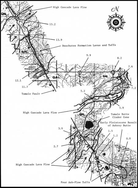
FIGURE 3. Geologic sketch map from mile 0.0 to mile 16.6.
(click on image for an enlargement in a new window)
|
|
| (2.2) |
|
| 5.2 |
Sharp turn right.
Roadway for next mile is on top of a High Cascade mafic lava
flow which moved W. to E. Lava is overlain by Pleistocene gravels. |
| (0.7) |
|
| 5.9 |
Left
turn leading to N.E. downgrade, N. margin of lava flow. Roadcuts on
right expose basal contact of lava resting on red, oxidized soil that
developed upon Tumalo Tuff. Nonwelded, pink upper zone of Tumalo Tuff
has been removed by erosion from lowlands to the N., revealing bedrock
of orange, welded Tumalo Tuff between patches of Pleistocene
gravel. |
| (1.3) |
|
| 7.2 |
Junction of Johnson Road and Tumalo Market Road. Desert Spring
Tuff is exposed in vicinity of the junction and rests upon Deschutes
Formation lavas. Turn left onto Tumalo Market Road. |
| (0.4) |
|
| 7.6 |
STOP NO. 1: Broad
shoulder on left side of road opposite orange-colored road cut.
Examine vertical section through Desert Spring Tuff. From creek bed to
road level: Partly collapsed black pumice fragments in pink,
devitrified, welded matrix are concentrated at base, but nearly absent
above. From road level to top of unit: Hydrated, orange and yellow,
poorly welded matrix with abundant fresh, noncollapsed pumice fragments.
Alluvial gravels on tuff are overlain by Bend Pumice. Exposed in quarry
a few 100-feet W: Bend Pumice overlain by very poorly welded and
nonwelded Tumalo Tuff which contains m fine-grained white
intralayer at its base. Exposed in roadcut and quarries a few
100-feet E: A NW-SE normal fault which dropped the section
about 12 feet on the N.E. side. Bedded pumice deposits are exposed at
roadway curve; they be long to the basal member of Bend Pumice and
consist of ash-fall and reworked pumice ash and lapilli. |
| (0.6) |
|
| 8.2 |
Turn left
onto Tumalo Reservoir Road; proceed west. Pleistocene alluvial gravels
mantle the nearby terrain. Quarries intermittently visible to the north
have been excavated wherever the overburden of alluvium and Tumalo Tuff
is sufficiently thin to permit extraction of Bend Pumice. |
| (1.7) |
|
| 9.9 |
Tyler Road. Recommended side trip to examine welded
facies of Tumalo Tuff. Follow Tyler Road 0.3-mile S., stop at base
of grade; outcrops are N.E. of the road. This was near to the N. margin
of the Tumalo ash flow. Pumice fragments as large as 1 foot contain
cores of the only fresh, white, nonhydrated glass to be found in this
unit. Along roadway ahead, alluvial gravels give way to scattered
outcrops of Deschutes Formation mafic lavas as the Tumalo Fault is
approached. |
| (1.8) |
|
| 11.7 |
End of Tumalo Reservoir Road; turn right and cross bridge over outlet stream
from Upper Tumalo Reservoir. Desert Spring Tuff forms S. bridge abutment;
Deschutes Formation lavas are exposed along the N. bank of the stream. This
road follows the Tumalo Fault for the next 7 miles. |
| (0.4) |
|
| 12.1 |
STOP NO. 2: Examine fine grained marginal facies of andesitic Shevlin
Park Tuff exposed along N.E. side of road. Bull Flat (W. of the road) is
underlain by Desert Spring Tuff, Bend Pumice, Tumalo Tuff, Shevlin Park Tuff, and
alluvium deposited on the down-dropped side of the Tumalo Fault.
Reactivation of the fault S.E. of Upper Tumalo Reservoir has displaced
the tuff units and alluvial gravels. |
| (1.8) |
|
| 13.9 |
Southeast abutment of Tumalo Dam.
Roadcut exposes an oxidized and devitrified andesitic welded tuff of the
upper part of the Deschutes Formation, interbedded here between Pliocene
mafic lavas. This tuff has been traced more than 16 miles N. and N.E.
into the Deschutes Basin. The N. abutment of the dam consists of
an open-textured early High Cascade basaltic andesite flow that
followed a stream channel through a gap in the fault scarp. The dam was
part of a WPA project in which Bull Flat was to become a reservoir to
store water brought by a flume system from the Deschutes River. For
rather obvious geologic reasons, filling the reservoir was found to be
impossible. The roadway ahead crosses over the High Cascade lava flow.
This flow is underlain by Desert Spring Tuff, overlain by Shevlin Park
Tuff, and has not been displaced by the Tumalo Fault. |
| (1.3) |
|
| 15.2 |
Road begins downgrade on N. margin of High Cascade lava flow. This is an
excellent point from which to view (S. to N.) Three Sisters, Black
Crater, and Mount Washington on Cascade skyline with Triangle Hill group
of cinder cones and lavas in middle distance covering the steep eastern
slope of an older silicic volcanic highland. Prominent hills M. of
Triangle Hill are Three Creek and Melvin Buttes - members of
a group of four Pleistocene rhyolite domes. Roadway ahead follows the
Tumalo Fault along which Deschutes Formation mafic lavas are exposed on
the N.E. side and Desert Spring Tuff is exposed in scattered outcrops
on the S.W. side. |
| (1.4) |
|
| 16.6 |
Boundary between geologic sketch maps, Figures 3 and 4. |
|
|
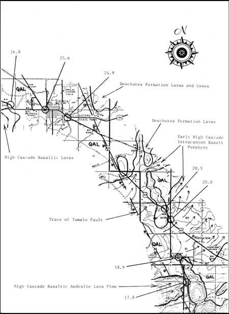
FIGURE 4. Geologic sketch map from mile 16.6 to mile 27.1.
(click on image for an enlargement in a new window)
|
|
| (1.2) |
|
| 17.8 |
Hill on the W. side of the road is the E. terminus of a High Cascade
basaltic andesite lava flow, Deschutes Formation lavas crop out on the
Tumalo Fault escarpment on the E. side of the road, |
| (1.1) |
|
| 18.9 |
Old Plainview School site. Turn left and follow Gist Road to
intersection with Highway 20. In this area alluvium mantles Desert
Spring Tuff to the S.E. and an early High Cascade basalt porphyry lava
to the N.W., both of which spread broadly to the N.E. and are
intracanyon to the Deschutes Formation. |
| (1.1) |
|
| 20.0 |
Intersection of Gist Road with Highway 20. Turn left on 20 toward
Sisters. |
| (0.5) |
|
| 20.5 |
Highway curves left around roadcuts in Deschutes Formation lavas. From
here to Sisters, Pleistocene alluvium and inconspicuous outcrops of
Pliocene mafic lavas are common. |
| (4.4) |
|
| 24.9 |
Junction Highways 20 and 126.
Pleistocene alluvium, most of alluvium is underlain in this basalt
flows. Proceed W. through Sisters. Sisters is built on which has been deposited
by Squaw Creek. The area by widespread High Cascade diktytaxitic
basalt flows. |
| (0.7) |
|
| 25.6 |
Junction Highways 20 and 242. Follow 242 W. toward McKenzie Pass,
Excellent view of Three Sisters volcanoes on S.W. skyline. |
| (1.4) |
|
| 26.8 |
Low outcrops on S. aide of the highway are of Pleistocene diktytaxitic
basalt from shield volcanoes to the S.W. For the next 2.5 miles the
highway ascends a slightly inclined surface over alluvial deposits which
are chiefly outwash sands and gravels. |
| (0.3) |
|
| 27.1 |
Boundary between geologic sketch maps, Figures 4 and 5. |
|
|
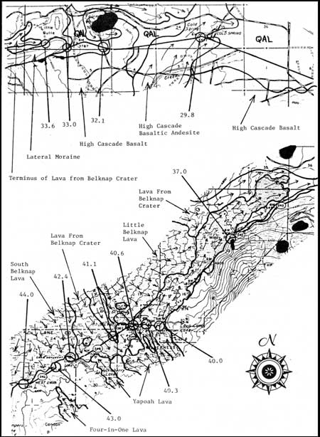
FIGURE 5. Geologic sketch map from mile 27.1 to mile 34.5 and
from mile 34.5 to mile 44.6.
(click on image for an enlargement in a new window)
|
|
| (2.7) |
|
| 29.8 |
Left-hand curve at site of Cold Spring. The spring issues from the
margin of m basaltic andesite lava flow whose source was a cinder cone
near South Matthieu Lake, 9 miles S.W. of here. The highway crosses the
surface of this flow for the next 1.1 miles, then ascends the surface of
an older basalt flow for an other 1.1 miles. |
| (2.3) |
|
| 32.1 |
Fourmile Butte can be seen about 0.5 mile to the M. Fourmile is one of
10 late Pleistocene mafic cinder cones between Black Crater and Black
Butte. So many lava flows issued from these cones that a lava field now
cowers approximately 25 square miles. The western part of the field is
buried under late Pleistocene moraine and outwash deposits. |
| (0.9) |
|
| 33.0 |
Sharp right-hand turn. The highway curves around the E. end of a
3-mile lateral moraine deposited along the S. side of a late
Pleistocene glacier. Little Butte, just M. of the highway, is a terminal
moraine. |
| (0.6) |
|
| 33.6 |
Secondary road N. This point marks the easternmost extension of Holocene
basaltic lava from Belknap Crater. Highway will follow the S. margin of
this flow for the next 3.2 miles. |
| (3.4) |
|
| 37.0 |
Windy Point. Glaciated promontory of basaltic andesite lavas and cinders
at the N.W. base of Black Crater. Excellent view of the broad shield of
Mount Washington surmounted by glaciated summit cone and plug. In
foreground is Holocene basaltic andesite lava from Yapoah Cone. Farther
N.W. is the lava field of Little Belknap. Highway ahead will follow the
margin of Yapoah lava for 3 miles. Outcrops of glaciated basaltic
andesite from Black Crater and basalt from smaller Pleistocene cinder
cones can be seen S.E. of the highway. |
| (3.0) |
|
| 40.00 |
Highway cuts through E. levee of
Yapoah flow. Several flow units can be seen
in which thin lenses of dense lava are separated by thicker layers of
rubble. |
| (0.3) |
|
| 40.3 |
STOP NO. 3: Dee Wright Observatory. From the observatory roof the
following
landmarks are seen proceeding clockwise from true north in azimuthal
degrees. |
|
| 0 |
Mount Jefferson: Andesitic composite volcano. |
| 7 |
Cache Mountain: Glaciated basaltic andesite
volcano, 0.9 m.y. old, with
late Pleistocene basalt cinder cones and lavas on summit. |
| 11 |
Bald Peter
(far horizon): Basaltic andesite volcano, 2.1 m.y. old, deeply
glaciated, constructed against the N. end of the Green Ridge fault
escarpment. |
| 20 |
Dugout Butte (forested foreground): Glaciated
diktytaxitic basalt flows
of the High Cascade platform. |
| 30 |
Green Ridge (far horizon): N-S fault block mountain, 20 miles
long. Escarpment faces W. Lavas on crest are 5-6 m.y. old. |
| 40 |
Black Butte (background): Basaltic cinder cone
located at S. end of Green Ridge. Older than any of the other visible
High Cascade volcanoes; well preserved form is due to lack of glaciation
east of the Cascade Range. Bluegrass Butte (foreground): Glaciated
basaltic andesite cinder cone. Ridge E. of cone is a lateral
moraine. |
| 82 |
Black Crater (fills most of eastern sector): Late
Pleistocene basaltic
andesite volcano. "Crater" is actually a glacial cirque open to the
N.E. |
| 105 |
Unnamed Cascade summit ridge composed of
glaciated basaltic andesite
to cinders, bombs, and lavas which issued from a 5-mile-long
chain of cones. |
| 155 |
Probably was the site of spectacular lava fountains and eruptions of
unusually large and abundant volcanic bombs during the late
Pleistocene. |
| 168 |
North Sister (elev. 10,085 feet). Basaltic andesite
composite volcano on a
broad shield. Central plug and dike systems exposed by glacial
erosion.
At base of North Sister stand Yapoah Cone (left) and Collier Cone
(right). |
| 174 |
Middle Sister (elev. 10,045 feet): Composite
volcano supporting Collier Glacier. Predominantly olivine basalt
porphyry but also contains flows of basaltic andesite, andesite, dacite,
and rhyodacite. Younger than North Sister. |
| 178 |
Summit of Little Brother and ridge W: Basaltic
composite volcano with
exposed plug and dikes. Older than North Sister. |
| 188 |
Four-in-One cinder cone (below
skyline): A ridge-cone breached in four
places by andesite lava flows, 2600 years ago. Part of a N-S
alignment of
19 vents. |
| 197 |
The Husband (on skyline, partly obscured): Although of late
Pleistocene age, it is one of the oldest and most extensively dissected
volcanoes in this region. The exposed plug of basaltic andesite is
1/4-mile in diameter. |
| 218 |
Condon Butte: Late Pleistocene cinder cone
surrounded by glaciated lava
field of basaltic andesite. Nested summit craters. Knob visible at
left
base is an unnamed glaciated dome of rhyodacitic obsidian. |
| 235 |
Horsepasture Mountain (far horizon): Western
Cascade peak. |
| 265 |
Scott Mountain: Small summit cone on a broad
glaciated basaltic shield. |
| 282 |
South belknap Cone: Cone was formed and breached
1800 years ago, then
surrounded by basaltic andesite lava from a nearby vent about 1500
years
ago. |
| 285 and 306 |
Unnamed twin steptoes (in foreground lava field): Glaciated basaltic an
desite volcanoes surrounded by lava from Little Belknap. |
| 309 |
Belknap Crater (summit cone on skyline): Focal point of a
long-continued and complex episode of Holocene basalt and basaltic
andesite volcanism. The broad shield which fills the N.W. view is 5
miles in diameter; it is estimated to be 1700 feet in maximum thickness
and 1.3 cubic miles in volume. The volcano probably contains a core of
cinders which interfingers with peripheral lavas and whose surface expression is the summit
cone. Basaltic andesite issued from vents at the north and south bases
of the cone approximately 1500 years ago. Lavas poured 12 miles to the
W. and ash was ejected from the northernmost of two summit craters. The
main bulk of Belknap ash, which has been traced over an area exceeding
100 square miles, was ejected earlier from a larger south crater. Still
earlier lavas were basaltic and moved eastward 7 miles from their
vents. |
| 321 |
Little Belknap: A subsidiary shield volcano,
built 2900 years ago on the
E. flank of the larger Belknap shield. |
| 340 |
Mount. Washington (elev. 7795 feet): Glaciated
remnant of a large basaltic
andesite composite volcano. Central plug is flanked by N-S swarm of
dikes
in summit cone. |
"Lava River Trail" east of the observatory: The
observatory is located on a blocky flow of basaltic andesite, erupted
from the base of Yapoah Cone between 2600 and 2900 years ago. The first
lobe of Yapoah lava moved over this area toward the N.W. but as it
advanced toward the opposing slope of Belknap Volcano, its movement was
checked, arcuate pressure ridges appeared on its surface, and subsequent
lava was deflected toward the N.E. The area just E. of the observatory
then became the main channel. The trail leads the visitor across the
center of this channel where the roof of a small lava tube collapsed and
a host of vertical cracks were produced in the lava by thermal
contraction and loss of gases just prior to final consolidation. On the
E. side of the main channel is an imposing levee. The visitor might well
imagine the channel in full flood, rising at least as high as the levee
crest and spilling over the eastern flank. When the supply of lava
diminished, the molten interior drained away and the channel surface
subsided. Lacking support, large segments of the levee tipped toward the
central channel, causing deep, irregular tension cracks to open in the
levee crest. The trail affords a view of one of these cracks and of
several lava tongues along the east base of the levee. |
| (0.3) |
|
| 40.6 |
Highway curves in
descent of Yapoah flow W. margin. Trees grow readily upon the younger
Yapoah flow but sparsely upon the older Little Belknap flow. This is
because the Yapoah surface is covered with blocks, interstitial scoria,
and fine particles; the Little Belknap surface is much more coherent. In
general, the extent of vegetation on Holocene lavas is governed more by
climate and surface characteristics than by age of the lava. Where the
highway leaves the Yapoah margin and crosses a pre-Belknap surface,
notice the dark soil. It is 3 feet thick and consists of lapilli and ash
chiefly from Belknap summit cone. |
| (0.5) |
|
| 41.1 |
Highway passes over the crest of a
Little Belknap lava tongue which poured S.E. down the older Belknap
shield. |
| (1.3) |
|
| 42.4 |
Craig Lake. Glacial striations can be seen on the
light-colored bedrock marginal to Belknap lava. Late Pleistocene
glaciers moved N.W. from here toward a valley that drained W. to
McKenzie canyon. The entire valley has been buried beneath the Belknap
shield. |
| (0.6) |
|
| 43.0 |
Highway is straight and level for 0.6 miles ahead where it
crosses an alluvial fill that has been deposited against the margin of
lavas from South Belknap cone. |
| (1.0) |
|
| 44.0 |
STOP NO. 4: Margin of lava from South
Belknap Cone. Belknap lava is distinct from Yapoah lava in its more
coherent, occasionally ropy surface on large, dismembered slabs and in
its abundant clusters of fine-grained glomerophenocrysts of plagioclase, olivine, and clinopyroxene. This lava
was erupted 1800 years ago. To the N. is an excellent view of S.
slope of Belknap volcano. Twin Craters cinder cone is visible to the W.;
It was act ive 2600 years ago. Next 1.1 miles leads over
glaciated lava from Condon Butte. |
| (0.6) |
|
| 44.6 |
Boundary between
geologic sketch maps, Figures 5 and 6. |
|
|
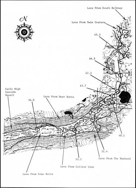
FIGURE 6. Geologic sketch map from mile 44.6 to mile 57.9.
(click on image for an enlargement in a new window)
|
|
| (0.7) |
|
| 45.3 |
Trail to Hand Lake. Hand Lake is
dammed by lava from Twin Craters. Highway leads S. across Lake Valley,
an area of low relief between lavas of Twin Craters to the N. and Sims
Butte to the S. Late Pleistocene glaciers moved S.W. over this valley on
their way to the head of Lost Creek canyon. Several lobes of ice
branched off through low divides to the W., excavating depressions in
the bedrock lava. The depressions are now occupied by lakes such as
Melakwa and Benson. Most of the valley floor is covered with reworked
deposits of volcanic ash from Belknap Crater, Sims Butte, and Mount
Mazama. |
| (1,2) |
|
| 46.5 |
Three Sisters view point. North Sister is a basaltic andesite composite
volcano on a shield base. Middle and South Sisters are younger, do not
rest upon shields, and are much more diverse in composition. Forested
slope in E. foreground consists of glaciated basalt flows from Little
Brother volcano. |
| (0.8) |
|
| 47.3 |
Right-hand curve followed by 0.4 miles of straight level highway
over reworked ash and lapilli from Sims Butte cinder cone, 0.5 miles
S.E. The alluvium was deposited in a depression along the N. margin of
Sims Butte lava. Sims Butte was active sometime during the interval
7,000 to 12,000 years ago, because Mazama ash occurs on Sims Butte lava
and cinders from Sims Butte rest upon latest Pleistocene glacial drift.
An 800-foot cone was built while short lava lobes spread N. and S.,
and ash and lapilli drifted N.E. Finally, a lava vent opened at the
western base and a large sector of the cone was carried away. |
| (0.4) |
|
| 47.7 |
Left-hand curve; highway crosses over the central part of the
western lobe of basaltic andesite lava from Sims Butte. The lava issued
from a vent 3000 feet E. of this point, spilled into Lost Creek canyon,
and covered the floor of the canyon to a point 9 miles W. of here. |
| (0.4) |
|
| 48.1 |
Parking area on left side of highway. High-standing margin of lava
from Collier Cone can be seen a short distance to the S. The next 3
miles of highway cuts and abrupt switchback turns present a seemingly
endless succession of thin, slaggy flows of basaltic andesite that
poured from Sims Butte down the walls of the Lost Creek glacial trough.
Occasional views of South Sister and The Husband are encountered. |
| (3.3) |
|
| 51.4 |
Hairpin
curve to the right with parking area. Recommended side
trip. Follow trail about 0.8 miles to Linton Lake. Trail crosses
over several nested lava levees and the central lava gutter, each of
distinct mineralogical and chemical composition, but all from Collier
Cone. Collier Cone was active sometime between 500 and 2500 years ago.
With respect to its variable composition, Collier Cone is similar to
the much-studied Mexican volcano, Paricutin. The Collier lava
dammed Linton Creek to form Linton Lake. |
| (2.1) |
|
| 53.5 |
Parking area and trail to Proxy
Falls. Recommended side trip. On the short trail to the
falls is a view of the Deer Butte plug and associated cinder cone,
enclosed within lavas of a shield volcano. As a result of intense
glaciation on the N. canyon wall, the entire butte is exposed in cross
section. The trail leads over the Collier flow, about 0.7 miles from its terminus. Many
waterfalls spill down the S. wall of the canyon: some are fed by
springs from interbeds between lava flows in the cliffs, but the main
Proxy Falls is that of a creek which drains a hanging valley, 800 feet
above. |
| (2.5) |
|
| 56.0 |
Parking area and road E. to Youth Camp. For the next 3 miles,
occasional views of the canyon walls reveal a sequence of diktytaxitic
basalt flows, up to 1500 feet in combined thickness, which forms the
base of the High Cascade platform. Flows in this vicinity have been
dated at 3.9 m.y. (near the base) to 2.1 m.y. (near the top). Individual
flows are thin, relatively coarse-grained aggregates of olivine
and augite set in a porous matrix of tabular plagioclase. Many of the
flows are separated by brick-red, baked soil horizons and interbeds
of sand and gravel. |
| (1.0) |
|
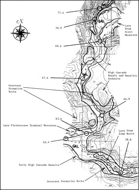
| 57.9 |
Boundary between geologic sketch maps, Figures
6 and 7. During the last major glaciation the canyon at this point was
so full of ice that a small lobe overtopped the lateral moraines on the
N. rim and moved 2 miles down an adjacent valley. |
|
|
FIGURE 7. Geologic sketch map from mile 57.9 to mile 72.3.
(click on image for an enlargement in a new window)
|
|
| (0.9) |
|
| 58.8 |
Clear area followed by
small bridge over White Branch Creek. Lost Creek and its tributaries
appear and disappear in springs and sinks in the Sims lavas. For the
next 3 miles all geologic features except Holocene lava and Pleistocene
glacial drift are obscured by luxuriant forest. In the canyon walls High
Cascade diktytaxitic basalt rests with erosional unconformity upon
volcanic and volcaniclastic rocks of the Western Cascades, chiefly the
Outerson Formation. |
| (3.6) |
|
| 62.4 |
Junction of Highways 242 and 126. Turn N. (right)
onto 126. Rest rooms, gasoline, and food are available at McKenzie
Bridge, 2 miles W. Highway cuts W. and E. expose terminal moraines
emplaced by the late Pleistocene glacier that emerged from the mouth of
Lost Creek canyon to the S.E. and nearly blocked the McKenzie drainage.
The McKenzie River was displaced to the N. side of the valley but was
apparently able to maintain its channel; no evidence of a related
backfill has been found upstream. High Cascade diktytaxitic basalt is
intracanyon to McKenzie River valley for at least 9 miles W. of here. For
5 miles down the McKenzie Valley, the intracanyon flows are represented
by a medial ridge (Foley Ridge). |
| (1.0) |
|
| 63.6 |
Road left to Belknap Hot Springs. One
of three hot springs in this area aligned N-S and probably
locallized by a fault zone which is partly buried by High Cascade lavas.
Rimrock cliffs on the W. side of the river are composed of
fine-grained basaltic andesite lavas resting upon a section of
diktytaxitic basalts. Both units are erosional remnants of a much more
extensive High Cascade sequence deposited on rocks of the Outerson
Formation along the eastern edge of the Western Cascades. |
| (1.3) |
|
| 64.9 |
Road to the
right leads up Scott Creek. Recommended side trip.
The High Cascade-Western Cascade boundary is located 2 miles up
this road. Below the boundary is an assemblage of nonporphyritic platy
basalts, porphyritic basalts, breccias, and tuffaceous interbeds which
are cut in many places by E-W normal faults and are generally
inclined to the S. Above the boundary is a section of nearly horizontal
palagonitic tuffs, basaltic pillows, dikes, and flows which are part of
the early High Cascade diktytaxitic basalt sequence. Above the
palagonitic tuffs is a series of thin-bedded, siliceous tuffs
capped by a thick intracanyon basalt flow whose columnar joints,
spiracles and pipe vesicles are excellently exposed. Roadcuts and canyon
walls along the next 10 miles of highway reveal mafic lavas and
volcaniclastic rocks of the Western Cascades,
variously faulted and inclined, overlain by Nigh
Cascade diktytaxitic basalts. The High Cascade basalts were often
pillowed where they apparently damned streams and formed lakes at the
base of the dissected Western Cascade escarpment. |
| (2.7) |
|
| 67.6 |
Deer Creek Road, left. On the opposite side of
McKenzie River are cliffs of
High Cascade basalt flows capping a hill of Western Cascade rocks. |
| (2.0) |
|
| 69.6 |
Ollalie Road, right. Forested slope immediately E. of the highway is the
margin of a basalt flow of late Pleistocene age from Scott Mountain,
6.5 miles to the E. This flow is similar to many others along the flanks
of the High Cascades in presenting a fresh, recent appearance at low
elevations, but as they are traced higher, they pass beneath glacial
moraines. At still higher elevations, near their source vents, they
have been extensively glaciated or even removed by glacial erosion. |
| (1.3) |
|
| 70.9 |
STOP NO. 5: Trailbridge Reservoir parking area. During examination of this
highway cut be mindful of potential hazards due to traffic, falling
rock, and impatient colleagues. Two geologists seldom reach complete
agreement as to the origin of this deposit. The rock unit of interest is
about 40 feet thick, gray and dense in the center, black to brown and
porous at top and bottom, and is offset in the cut by four normal
faults, giving rise to a set of small fault blocks inclined down to the
N.E. In most outcrops the unit rests upon mafic lava flows and is
overlain by mudflows or lavas. In my opinion this unit is an ignimbrite
of basaltic andesite composition (SiO2 53 to 54), laid down
by a very hot pyroclastic flow. It might have moved in part, as a mobile
lava-foam or froth-flow, prior to intense welding. The unit
contains too many pertinent features to be adequately described here,
but a field geologist will note the following at first observation: (1)
Basaltic composition with phenocrysts of olivine, pyroxene, and
plagioclase, (2) vertical zonation of rock fragments (most abundant in
the lower one-third of the deposit), (3) lack of sorting with
regard to size or density such that large and small, highly vesicular
fragments are mixed with respect to dense, compact fragments, (4)
micro-vesicular top and base without rubble or flow breccia,
(5) distinct preferred orientation of elongate fragments parallel to
the base, (6) marginal assimilation and discoloration of silicic rock
fragments, and (7) a lack of eutaxitic texture or of any other
particulate character in the matrix. In several other outcrops the basal
6 feet of the unit contains persistent layers, 0.5 to 4.0 inches thick
with sharp interfaces, passing gradually upward into the dense and
homogeneous interior. Additional features, not revealed by a brief
examination of an outcrop, include: (1) Holocrystalline pilotaxitic
groundmass in the dense interior, (2) lack of hydrous phenocrystic
phases, (3) ubiquitous, fine-grained, secondary chabazite in the
porous basal layers, and (4) a reverse paleomagnetic orientation
throughout. Some of the included fragment lithologies are common
elsewhere in this area and some are not; among the latter are gabbroic
and dioritic porphyries. This deposit has been traced without noteable
change in features, discontinuously for 7 miles N-S, and apparently
was derived from the E. rather than the W. As a distinctive marker bed,
it has been used to unravel structural complications (chiefly faulting)
in the Outerson Formation west of the upper McKenzie River. A bulk
sample of the dense interior has been dated by K-Ar at 5.0
m.y. |
| (0.5) |
|
| 71.4 |
Right-hand curve; hydroelectric powerhouse on opposite side of
McKenzie River. Water is conducted to the facility through m tunnel from Smith River
Reservoir
2 miles W. Highway cuts on the right show several springs emerging from
an
aquifer of High Cascade pillow basalt. |
| (0.9) |
|
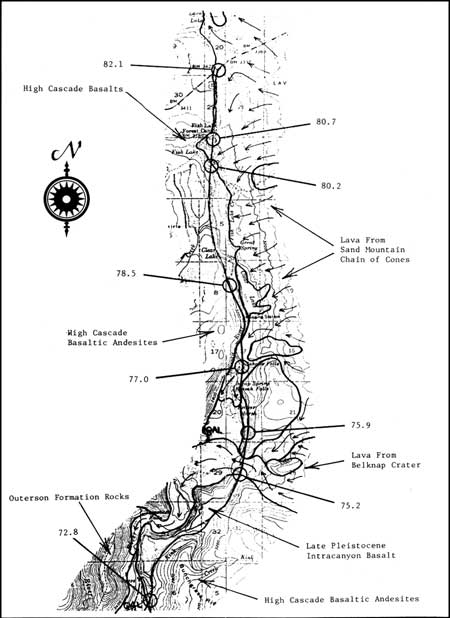
| 72.3 |
Boundary between geologic sketch maps, Figures 7 and 8. |
|
|
FIGURE 8. Geologic sketch map from mile 72.3 to mile 83.5.
(click on image for an enlargement in a new window)
|
|
| (0.5) |
|
| 72.8 |
Highway fill over Kink Creek valley. Beginning of a long grade up onto
the crest of a sequence of thin High Cascade basalt flows which are
intracanyon to the upper McKenzie River. The flows are well exposed in
highway cuts for the next mile. |
| (2.4) |
|
| 75.2 |
South margin of Holocene basalt flow.
Lava from the N. base of Belknap Crater, 8 miles S.E., entered the
McKenzie River canyon here, 1500 years mgo. The flow poured in a double
cascade down cliffs to the W. and spread out upon the canyon floor,
extending another 2 miles downstream. During the Pleistocene, prior to
development of the Belknap shield volcano and related lava fields, the
entire western discharge of meltwater from ice between Mount Washington
and Black Crater joined the McKenzie River at this point. Lava flowed
through this valley into the McKenzie River canyon many times; the
intracanyon basalt flows seen in highway cuts for the last 2 miles were
so derived. |
| (0.7) |
|
| 75.9 |
Series of highway cuts and cliffs to the right expose many thin lava
flows dated at 1.2 m.y. They are probably a part of a large early High
Cascade basaltic andesite shield volcano whose central plug and flanking
lavas can be seen in the opposite wall of McKenzie River canyon, 1 mile
W. |
| (1.1) |
|
| 77.0 |
Sahalie Falls parking lot, Recommended scenic stop.
Two thick flows of basaltic andesite lava from the Sand Mountain chain
of cinder cones (3.3 miles E. of here) moved into McKenzie River canyon
in this area, 3000 years mgo. The terminus of the first flow is marked
by Koosah Falls, 0.4 miles downstream. The second flow, whose terminus
is marked by Sahalie Falls, is seen in the highway cut ahead. |
| (1.5) |
|
| 78.5 |
Road on
right to Clear Lake. Clear Lake is 1.5 miles long, fed by large springs,
and is more than 120 feet deep in places. It was formed behind a dam of
lava which issued from a cinder cone S. of Sand Mountain and poured
across the McKenzie River. Rising waters inundated a standing forest;
several dozen snags are still rooted on the lake floor. Wood from the
snags and charcoal from beneath the east-shore lavas are both 3000
C-14 years old. |
| (1.7) |
|
| 80.2 |
South margin of Holocene lava and outlet channel from Fish Lake. The
lava came from early vents of the Sand Mountain chain of cinder cones
and dammed Hackleman Creek to form Fish Lake 3800 years mgo. The lava
is basaltic and relatively thin with smooth ropy surfaces; tree molds
are common. |
| (0.5) |
|
| 80.7 |
Road to Fish Lake Campground on left. Highway crosses from
3800-year-old basaltic flow to younger, thicker, blocky
basaltic andesite flow from Nash Crater. Fish Lake is dry during each
summer, but this apparently was not the case before the 1900's,
Lava-dammed lakes are sometimes sensitive indicators of changing
climate. |
| (1.4) |
|
| 82.1 |
Junction of Highway 126 with Highway 20. Turn right (east) on 20. The
junction area has been invaded by Holocene basalt flows on three
separate occasions:
(1) 3800 years mgo from a group of cones between Nash Crater and Sand
Mountain (lava now exposed on the floor of Lava Lake, 0.5 miles N.), (2)
subsequently from a buried vent near Nash Crater (lava surrounding the
junction), and (3) about 3000 years mgo from exposed vents at the N.W.
base of Nash Crater (blocky lava front about 200 feet S. of the
junction). |
| (1.4) |
|
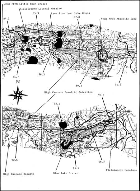
| 83.5 |
Boundary between geologic sketch maps, Figures 8 and 9.
Sawyer's Cave, adjacent to the highway on the right, is a short lava
tube with a well-preserved ropy crust on its eastern floor. |
|
|
FIGURE 9. Geologic sketch maps from mile 83.5 to mile 91.6 and from
mile 91.6 to mile 99.8. (click on image for an enlargement in a new window)
|
|
| (0.6) |
|
| 84.1 |
Gradual
right-hand curve across a lava field composed of basaltic andesite
flows (S.E. of the highway) from Nash Crater and younger flows (N.W. of
the highway) from Little Nash Crater. Fine ash from Nash Crater fell on
both of these flows, but the resulting deposit is thin and to be seen it
must be recovered from interstices in the lavas. |
| (0.6) |
|
| 84.7 |
Road to quarries in
Little Nash Crater, left, Recommended side trip,
but not suitable for a large bus. Follow gravel road to top of cone.
Watch for trucks. Little Nash Crater has been breached on the W. by
lavas which extend from the base of the breached area, westward for 1.7
miles. The quarried areas are littered with discarded volcanic bombs and
bomb fragments up to 4 feet in diameter. The top of the cone affords m
good view of the maturely dissected Western Cascade escarpment and
nearby High Cascade Holocene cones and lava fields. Follow a gravel road
W. and N. from the cone to Highway 22 and examine the large road cut N.
of 22. It reveals a later Pleistocene terminal moraine mantled with a
thin layer of Mazama ash, overlain by a bed of fine mafic ash from Nash
Crater. This is overlain by coarse rock fragments blasted from bedrock
and moraine over the Little Nash Crater vent. The top layer in the cut
consists of mafic lapilli from Little Nash Crater. Turn E. on Highway
22. |
| (0.6) |
|
| 85.3 |
Santiam Junction; Highways 20 and 22. Continue E. on 20. Late
Pleistocene lateral moraines form ridges to the N. and S. of the
junction area, outlining the last advance of glacial ice. Holocene
volcanic activity in the junction area includes: (1) early basalt flows
that moved N.W. toward Lava Lake from vents between Nash Crater and Sand
Mountain, (2) basalt flows from Nash Crater, (3) development of the Lost
Lake chain of cones and associated basalt flows, and (4) basaltic
andesite flows from the S. and N.W. bases of Nash Crater. During this
last phase of activity at Nash Crater, Little Nash Crater was formed and
breached by flows of basaltic andesite. All of these volcanic episodes
deposited lava or ejecta or both in the vicinity of Santiam
Junction. |
| (1.0) |
|
| 86.3 |
Broad left-hand curve around S. cone of Lost Lake chain of
cinder cones. In this part of the chain, three cones were constructed
across a glacial canyon and the resulting ridge dammed Lost Creek to
form Lost Lake (one mile ahead). The cone N. of the highway contains m
crater 1000 feet wide and 300 feet deep. |
| (1.5) |
|
| 87.8 |
In highway cuts and on hillside N. of the highway are several outcrops
of columnar and platy-jointed basaltic andesite lava from m
glaciated cone, 1.5 miles N.E., near Craig Lake. Older rocks in the S.
wall of this canyon have been dated by K-Ar at 0.43 m.y. The lavas
are overlain by a mantle of reworked mafic ash, chiefly from Lost Lake
Cones and Little Nash Crater. |
| (1.5) |
|
| 89.3 |
Broad left-hand curve around W. margin of Hogg Rock. Very well
developed platy jointing in a glaciated volcanic dome of nearly aphyric
andesite. Remnants of a columnar-jointed black glassy margin can be
seen. View to the N. includes Three Fingered Jack; to the N.W., Maxwell
Butte; to the W., Lost Lake chain of cones. Hoodoo Butte and Hayrick
Butte can be seen to the S. Hoodoo is a cinder cone with a summit
crater, shielded from Pleistocene glaciation by Hayrick Butte, which
stood as an elongate andesite dome, in the path of the advancing ice. |
| (1.9) |
|
| 91.2 |
Summit of Santiam Pass, Northern margin of m
large glaciated field of basaltic lavas which spread E. and W. from
cones and lava vents along the High Cascade crestline from Highway 20,
S. to Mount Washington. It should be noted that red cinders, so
prevalent on road cuts between Little Nash Crater and Suttle Lake, have
been deposited by snowplows and are not part of the natural stratigraphy. |
| (1.4) |
|
| 92.6 |
Trailhead to Square Lake, left. From this point
to the E. base of the High Cascade platform, basaltic andesite lavas of
reverse paleomagnetic polarity are exposed in highway cuts. |
| (2.5) |
|
| 95.1 |
Blue Lake
overlook, right. Blue Lake occupies a Holocene crater surrounded by a
rim of cinders, spatter, and bombs of basaltic andesite, ejected 3500
years mgo. Although no lava appeared, the eruption must have occurred
with considerable violence, for most of the crater was blasted out of
solid bedrock and large fragments were scattered in all directions. The
landscape is blanketed with cinders for 3 miles E. and
S.E. |
| (0.4) |
|
| 95.5 |
Left-hand curve, Highway cuts in thick, platy-jointed
basaltic andesite flows have been dated by K-Ar at 0.54 m.y., but
must be at least 0.7 m.y. because they possess reverse paleomagnetic
polarity. |
| (1.0) |
|
| 96.5 |
Midpoint of long downgrade N. of Suttle Lake. Glacial drift of a late
Pleistocene lateral moraine which forms an E-W ridge 2 miles long
and 600 feet high is exposed in N. side highway cuts. Suttle Lake rests
in an elongate basin enclosed by lateral and terminal moraines. Cache
Mountain and Mount Washington are prominent to the S.W. |
| (1.3) |
|
| 97.8 |
Road to Blue Lake, right. Next 0.5 miles of highway will lead through
late Pleistocene terminal moraines. This represents the lowest elevation
reached by an eastward extension of the ice sheet which accumulated
between Mount Washington and Three Fingered Jack. The moraines are
covered with 0.5 to 1.0 feet of fine ash from the Sand Mountain chain of
cinder cones and by approximately 1 foot of younger cinders from Blue
Lake Crater. |
| (2.0) |
|
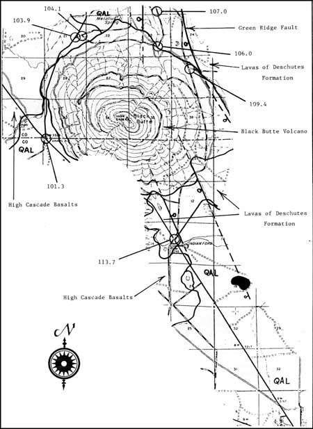
| 99.8 |
Boundary between geologic sketch maps, Figures 9 and 10.
Highway leads over irregular surface underlain by a widespread field of
Pleistocene diktytaxitic basalt flows. |
|
|
FIGURE 10. Geologic sketch map from mile 99.8 to mile 119.0.
(click on image for an enlargement in a new window)
|
|
| (1.5) |
|
| 101.3 |
Junction. Leave Highway 20, turn left on road to Metolius River and Camp
Sherman. Route ahead will lead clockwise around the base of Black Butte.
The butte is 3200 feet high and 4 miles in diameter. It is a composite
cone of basaltic cinders and lavas constructed at the S. end of the
Green Ridge fault escarpment. In spite of its youthful profile, Black
Butte is older than many of the dissected High Cascade volcanoes such as
Three Fingered Jack and Mount Washington, probably because it stands in
the rain shadow of the Cascades. It has no summit crater, deep gullies
are incised on its flanks, rocks on its surface have a relatively
thick, weathered rind, and its lavas possess reverse paleomagnetic
polarity. K-Ar ages average 0.45 m.y., but the standard errors are
large. The next 2 miles of roadway lead over a forested lava field of
diktytaxitic basalt which overlies lavas from Black Butte. |
| (2.6) |
|
| 103.9 |
Junction. Turn
right on U.S.F.S. No. RD 14 to "Head of Metolius," |
| (0.2) |
|
| 104.1 |
Secondary road, U.S.F.S. No. RD 1430, turn
right and follow this road uphill for 3 miles. The Metolius River
emerges from large springs at the N. base of Black Butte, 1 mile E. of
this point. Black Butte and younger Cascade lavas buried the channel of
a north-flowing ancestral Metolius River. Groundwater still moves
through this channel, emerging at the N. margin of Black Butte lava.
Large boulders of Black Butte lava are abundant along this road, but no
outcrops will be seen. |
| (1.9) |
|
| 106.0 |
Left-hand turn from N. slope of Black Butte
to W. slope of Green Ridge. Intermittent outcrops of Pliocene mafic
lavas separated by flow breccias will he seen for the next 1 mile. |
| (1.0) |
|
| 107.0 |
STOP NO. 6: find viewpoint near top of grade. Parts of one of the most
significant structural features on the E. flank of the central Cascades,
namely the Green Ridge fault block, can be seen from this point. The
west-facing escarpment extends N. for 15 miles and rises 2000 feet
above the Metolius River valley. Basalt, basaltic andesite, and andesite
lavas with interbedded ash flow and air-fall tuffs ranging in age
from 5.0 to 9.2 m.y., occur in the face of the escarpment; they have
been traced E. into the correlative Deschutes Formation. Magmas of
Black Butte probably ascended through the Green Ridge fault zone and a
well preserved mafic cinder cone and lava flow of Pleistocene age also
rests on the fault trace, 3.0 miles N. of here. Several High Cascade
peaks can be seen to the W. Most prominent are Mount Washington (S.W.),
Three Fingered Jack (W.), and Mount Jefferson (N.W.). |
| (0.3) |
|
| 107.3 |
Junction with Allingham Road, U.S.F.S. No. RD 1120. - Turn right and
follow RD 1120 south. The hillside visible about 0.5 miles E. is the S.
end of the main Green Ridge escarpment; the roadway leads across part of
a ramp structure between two parallel faults. Large altered boulders of
Deschutes Formation lava will be seen along the roadside for the next 5
miles. |
| (2.1) |
|
| 109.4 |
Junction with road leading E. (RD 1139). Continue south on
U.S.F.S. RD l1 to rejoin Highway 20. |
| (4.3) |
|
| 113.7 |
Junction with Highway 20. Turn left toward Sisters. From here to Sisters
the highway crosses a nearly flat alluvial plain chiefly consisting of
late Pleistocene outwash sands and gravels from High Cascade glacial
systems. The alluvium rests upon early Pleistocene lava flows and is
overlain by late Pleistocene cinder cones and associated lavas. |
| (5.3) |
|
| 119.0 |
Boundary between Geologic Sketch Maps, Figures 10 and 11. Junction
of Highways 20 and 242; Town of Sisters. Proceed E. through
Sisters. |
|
|
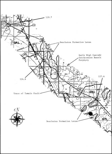
FIGURE 11. Geologic sketch map from mile 119.0 to mile 129.1.
(click on image for an enlargement in a new window)
|
|
| (0.7) |
|
| 119.7 |
Junction of Highways 20 and 126. Proceed S.E. on 20 toward
Bend. |
| (4.9) |
|
| 124.6 |
Junction of Gist Road and Highway 20. Proceed toward Bend on 20. For
the next 2 miles, the highway crosses a flow of early High Cascade
basalt porphyry which spread 9 miles N.E. and entered Deep Canyon in the
Deschutes Basin. |
| (3.0) |
|
| 127.6 |
Right-hand curve and junction of Fryrear Road with Highway 20. Low
hills on both sides of the highway are composed of Pliocene basaltic
andesite lavas near the top of the Deschutes Formation. Straight and
level part of highway for 2.2 miles ahead is underlain by Desert Spring
Tuff, obscured by alluvial cover toward the N.W. |
| (1.5) |
|
| 129.1 |
Boundary of Geologic Sketch Maps, Figures l1 and 12. |
|
|
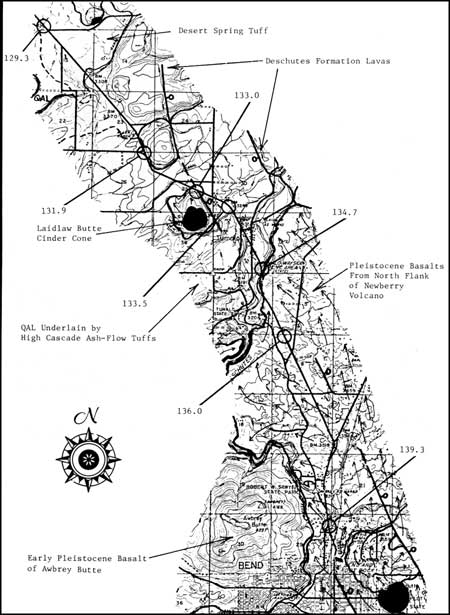
FIGURE 12. Geologic sketch map from mile 129.1 to mile 142.0.
(click on image for an enlargement in a new window)
|
|
| (0.2) |
|
| 129.3 |
Gully
trending N.E. has exposed pink Desert Spring Tuff in both banks. The ash
flow moved N.W. in this area, toward Dry Canyon. Hill 0.7 miles E. is an
early Pleistocene cinder cone. |
| (2.6) |
|
| 131.9 |
Junction of Couch Market Road and Highway
20. The low hill E. of the highway is a small block of upper Deschutes
Formation mafic lava bounded by northwest-trending normal faults.
Dozens of such faults occur N.E. of the Tumalo Fault between Green Ridge
and Bend: they are part of the Brothers-Sisters Fault Zone. |
| (1.1) |
|
| 133.0 |
Laidlaw
Butte on the right. Laidlaw is a Pleistocene cinder cone which was
active after Desert Spring Tuff, Bend Pumice, and Tumalo Tuff were
deposited in this area. |
| (0.5) |
|
| 133.5 |
Right-hand curve and downgrade to floor of
Deschutes River valley. Highway cuts along the grade expose pink
nonwelded Tumalo Tuff in a position close to the N.E. margin of the
Tumalo ash flow. The ash flow moved 3 miles farther N.E. and an unknown,
but probably much greater distance eastward, where it is now buried
beneath Pleistocene lava fields. |
| (1.2) |
|
| 134.7 |
Highway 20 crosses Deschutes River. Alluvium on the valley floor has
been quarried for gravel. Highway grade up the E. valley wall exposes
Bend Pumice and Tumalo Tuff (which are underlain by Desert Spring Tuff
at water level), overlain by gravel beds. At the top of the grade,
basaltic lava flows rest upon the gravels. |
| (1.3) |
|
| 136.0 |
One of several Highway cuts through basaltic lava
which exposes pressure ridges in cross section. The lava was moving N.W.
in this area from late Pleistocene vents on the N. flank of Newberry
Volcano. The Deschutes River was forced westward to its present course
along the west margin of the lava field. The city of Bend, E. of the
river, has been built upon this lava field. |
| (3.3) |
|
| 139.3 |
Junction of Highway 97 and
route to city center. Turn right and proceed to downtown Bend. Turn
right again at Newport Avenue. Proceed to College Way and completion of
field trip circuit at 142.0 miles, |
REFERENCES
Armstrong, R. L., Taylor, E. M., Hales, P. O., and
Parker, D. J., 1975, K-Ar dates for volcanic rocks, central
Cascade Range of Oregon: Isochron/West, No. 13, p. 5-10.
Peck, D. L., Griggs, A. B., Schlicker, H. G.,
Wells, F. G., and Dole, H. M., 1964,
Geology of the central and northern parts of the Western Cascade Range
in Oregon:
U.S. Geol. Survey Prof. Paper 449, 56 p.
Peterson, N. V., Groh, E. A., Taylor, E. M., and
Stensland, D. E., 1976, Geology and
mineral resources of Deschutes County, Oregon: Ore. Dept. Geol. Min.
Ind., Bull. 89, 66 p.
Scott, W. E., 1977, Quaternary glaciation and
volcanism, Metolius River area, Oregon:
Geol. Soc. Am. Bull., v. 88, p. 133-134.
Sutter, J. F., 1978, K-Ar ages of Cenozoic
volcanic rocks from the Oregon Cascades west of 121°30':
Isochron/West, No. 21, p. 15-21.
Taylor, E. M., 1968, Roadside geology, Santiam and
McKenzie Pass Highways, Oregon: Ore. Dept. Geol. Min. Ind. Bull., v.
62, p. 3-33.
______, 1978, Field geology of S.W. Broken Top
Quadrangle, Oregon: Ore. Dept. Geol. Min.. Ind., Special Paper
2, 50 p.
Thayer, T. D., 1937, Petrology of later Tertiary and
Quaternary rocks of the north-central Cascade Mountains in Oregon:
Geol. Soc. Am., Bull. 48, p. 1611-1652.
circ/838/roadlog3.htm
Last Updated: 28-Mar-2006
|


