|
THE RIVER AND THE ROCKS
The Geologic Story of Great Falls and the Potomac River Gorge |
THE RIVER AND THE LAND

Roaring waters
All landscapes are the result of a continuing struggle between the deep-seated earth forces that raise the land above sea level and the forces of erosion that gradually wear down the land's surface. Sedimentation—the deposition of the products of erosion—modifies the landscape only slightly. Erosion begins with the weathering of rocks—the chemical decay and solution of mineral grains and the mechanical disintegration of rocks by frost. The resulting debris is carried into streams and rivers by running water, again aided by frost action and the slow creep of soil down the slopes. Once in the streams the debris is transported seaward, partly in solution, partly as mud and silt in suspension, and partly as sand, gravel, and boulders. The Potomac River is estimated to carry more than 1.6 million tons of sediment and 1.1 million tons of dissolved material over the falls each year. This amounts to 230 tons of material removed from each square mile of the river's drainage area above the falls.
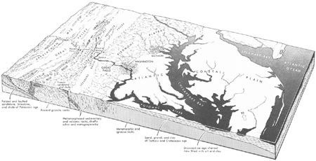
The Potomac, like other Atlantic seaboard rivers, heads in the Appalachian Mountains and flows eastward to the Atlantic Ocean. The river crosses the Blue Ridge through a narrow gap below Harpers Ferry and cuts across Catoctin Mountain, the easternmost ridge of the Appalachians, through a similar gap at Point of Rocks. From there to its mouth at Chesapeake Bay, the river flows across three major landscape provinces: a broad lowland between Point of Rocks and Seneca that is called the Frederick Valley in Maryland and the Leesburg Basin in Virginia; the Piedmont Plateau, between Seneca and Washington; and the Atlantic Coastal Plain, between Washington and Chesapeake Bay.

|
| Block diagram of the D. C. region showing physiographic provinces and geographic and geologic features. (click on image for an enlargement in a new window) |
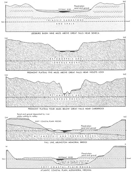
The nature of the landscape and river valley in each of these provinces is determined largely by the nature of the underlying rocks. The Frederick Valley and Leesburg Basin are underlain principally by red sandstone and shale that were deposited during the Triassic Period, about 200 million years ago. Because these rocks are rather easily eroded, the land's surface is nearly flat; slopes are gentle and smooth. The river is wide, sluggish, and shallow and is flanked by broad flats frequently covered by floodwaters.
The Piedmont Plateau is a rolling, hilly upland underlain by hard rocks. Although these rocks are very resistant to erosion, they are subject to chemical decay which in places extends to depths of 100 feet and produces deep red clayey soils. The smaller streams on the uplands have not cut through the blanket of soil and decayed rock and thus flow in broad valleys and wide flood plains, but the larger streams have cut through to hard rocks and flow within narrow steep-sided valleys having constricted flood plains.
The nature of the valley of the Potomac across the Piedmont Plateau is quite variable. Above Great Falls the valley is steep sided but wide, and in most places the river is broad, shallow, and placid; in a few places, however, riffles and rapids break the quiet water as it passes across resistant ledges of rock. The numerous islands are composed of sand and gravel laid down by the river, and none of them rise much above the level of the flood that occurs about once every 2 years. At Great Falls the character of the river changes abruptly. From there to Theodore Roosevelt Island it flows within a series of narrow rock-girded channels twisting between cliffs and flat-topped bedrock islands that rise high above the level of the highest known floods. Passing over a series of rapids and low falls, including Yellow Falls, Stubblefield Falls, and Little Falls, the river reaches approximately the level of the sea at Chain Bridge.
As the river flows beneath the Arlington Memorial Bridge, it leaves the Piedmont Plateau and enters the Atlantic Coastal Plain. The Coastal Plain is underlain by layered deposits of sand, clay, gravel, and shells laid down in the sea when it encroached onto the eastern edge of the continent at various times during the past 100 million years. In cross section, these deposits resemble a gigantic wedge ranging from thicknesses of a few feet near the inland edge to nearly 10,000 feet along the Maryland coast. Chesapeake Bay and its system of estuaries are ancient valleys cut in the soft sediments of the Coastal Plain when sea level stood much lower. When the sea rose to its present level, the valleys were flooded. The Potomac River occupies one of these "drowned" valleys between Washington and its mouth at Point Lookout. The broad river, here affected by tides and navigable by oceangoing ships, is flanked by wide low flood plains and, in a few places, by bluffs carved out of the soft Coastal Plain rocks by waves.

|
| Cross sections of Potomac River Valley showing typical shape in each landscape province (each cross section is approximately 4 miles long). (click on image for an enlargement in a new window) |
The boundary between the hard rocks of the Piedmont Plateau and the soft, easily eroded rocks of the Coastal Plain is called the Fall Line because it is the line along which falls and rapids are first encountered in ascending the major rivers. It marks the head of navigation for oceangoing ships and the farthest point downstream that the streams can be crossed by fords or small bridges. For this reason, many of the cities of the eastern seaboard from Trenton, N. J., to Macon, Ga., were established along the Fall Line.
Although the nature of the river valley is largely controlled by the properties of the underlying rocks, these alone are not sufficient to explain the origin of the falls and the Potomac Gorge. If they were, one would expect Great Falls to lie at the Fall Line, rather than 15 miles upstream in the middle of the Piedmont Plateau. The reason for the present location of Great Falls must be sought through studies of the geologic history of the Potomac River valley.

| <<< Previous | <<< Contents >>> | Next >>> |
usgs/great_falls/sec3.htm
Last Updated: 01-Mar-2005