|
Geological Survey
The Geologic Setting of the John Day Country, Grant County, Oregon |
ROAD LOG OF THE JOHN DAY "LOOP"
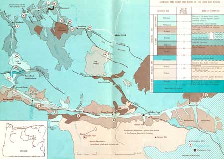
NOTE: Mileages at lettered stops on the map (Fig. 1) refer to nearby mile posts. These are not in numerical order because the route covers parts of four different numbered highways. By taking the tour clockwise, the traveler will be at higher altitudes later in the day.

|
| Fig. 1.—Geologic map of the John Day Country showing road log route. (click on image for an enlargement in a new window) |
| A. 155.4 |
Holliday Rest Area. The main John Day fault, which here is buried under river gravel, is believed to be just south of the rest area. A parallel step fault (Fig. 2) cuts from left to right across the southern slope of Mt. Vernon Butte about where the juniper trees thin out. Flows of Picture Gorge Basalt in the upper part of the butte slope down to valley level on your left. Rocks in the foreground and to the right are rudely bedded volcanic breccias of the Clarno Formation. The Clarno Formation has been raised as much as 250 feet by movement along the fault to position it against the basalt as indicated in the diagram. The fault can be seen best in afternoon light in the ravine to the right, just south of some brick-red layers in the basalt. Movement on the main John Day fault to the south appears to have raised the rocks at least 1,000 feet, so the two faults have stairstepped the rock layers. The main John Day fault has been traced about 80 miles. | ||
| |||
| B. 144.0 |
Fields Creek Road. In the road cuts just south of the highway, the John Day fault (Fig. 3) passes through the Mascall Formation where the slope or dip of the beds changes abruptly from gently southward to steeply northward. The fault continues westward under the floor of the valley. Fossil leaves and snails can be found in the beds south of the fault, and 1,000 feet farther south vertical Picture Gorge Basalt flows are exposed. To the north across the valley at the White Hills, beds of the Mascall Formation have been dropped down against the Picture Gorge Basalt along the Belshaw fault. The White Hills are a well-known locality for collecting fossil leaves. | ||
| |||
| C. 138.5 to 135.0 |
Vertical Ribs. The prominent vertical ribs, visible south of the river in steep slopes below the high bench (pediment), are flows of Picture Gorge Basalt tilted vertically in the north limb of the Aldrich Mountain anticline. The John Day fault follows the base of the steep front in which the ribs are exposed. | ||
| D. 132.6 |
Volcanic Ash Flow. The rimrock north of the John Day River between here and Dayville is a volcanic ash flow that erupted about five million years ago as red hot pumice highly charged with gas. A rapidly moving incandescent cloud probably filled the ancient John Day River valley and deposited ash to a depth of more than 100 feet over a distance of 60 to 70 miles. As shown in Figure 4, the ash flow blankets about 200 feet of gravels that had been deposited in the valley. The rimrock and the gravels above and below it constitute the Rattlesnake Formation. | ||
| |||
| <<< Previous | <<< Contents >>> | Next >>> |
inf/john_day/sec3.htm
Last Updated: 28-Mar-2006


