
|
Geological Survey Professional Paper 1356
Neogene Tectonics and Geomorphology of the Eastern Uinta Mountains in Utah, Colorado, and Wyoming |
CRITICAL RELATIONSHIP OF THE BROWNS PARK FORMATION TO THE BISHOP CONGLOMERATE NEAR LILY PARK
Although there are thus two distinctly different conglomerates at the base of the Browns Park Formation east of the Uinta Mountains, they are not of themselves wholly incompatible with Sears' early view (1924a) that the Bishop Conglomerate is the basal conglomerate of the Browns Park Formation. Exposures in the Lily Park area, however, especially in the canyon of the Little Snake River between the east end of the Uinta Mountains and Cross Mountain, demonstrate the topographic and sedimentological discontinuity between the Bishop Conglomerate and the Browns Park Formation.
West and south of Cross Mountain, at Klauson Pasture, Horse Gulch (on the west flank of Cross Mountain), and Twelvemile Mesa, thick terrace deposits of conglomerate stand high above the valleys of the Little Snake and Yampa Rivers, lapping across the older formations (fig. 20; see also fig. 9, bottom). These deposits have been referred to by earlier investigators as the lower conglomerate unit of the Browns Park Formation, but they are here regarded as Bishop. The conglomerate cap at Twelvemile Mesa merges to the south with the conglomerate of Elk Springs Ridge, which in turn merges westward with the remnants that P. D. Rowley, P. E. Carrara, and I mapped as Bishop Conglomerate along the south flank of the Uinta Mountains (Rowley and others, 1979). The deposits on Twelvemile Mesa and Klauson Pasture have the typical Uinta Mountains lithologic affinities and are practically identical; the Horse Gulch deposit is largely local material derived from the slopes of Cross Mountain, but all three deposits are clearly correlative geomorphically and must have once have been a continuous body of gravel resting on one surface.
|
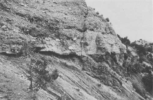
| FIGURE 20.—Poorly sorted, poorly bedded Bishop Conglomerate resting unconformably on truncated Morrison Formation, west flank of Cross Mountain, Moffat County, Colo., about 120 m above valley floor. This sequence was considered by earlier investigators to be the basal conglomerate of the Browns Park Formation. Boulder at center of photograph is 60 cm across. Compare with figure 22. |
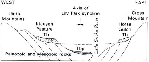
This surface, restored, has a northerly component of slope caused by postdepositional tilt. Near the north end of Cross Mountain it ends as a terrace, although it once may have continued north some distance be neath the Browns Park Formation, just as it still does to the south at Elk Springs. Field evidence on that point is unclear. However—and this relationship is critical—the Browns Park Formation extends tongue-like down the canyon of the Little Snake River at a level lower than the outcropping conglomerate, to and beyond the point where Klauson Pasture and the bench at Horse Gulch project toward one another (fig. 21). Beneath the sandstones of the Browns Park Formation at that point, a well-stratified, horizontally bedded basal conglomerate about 5 m thick rests on a bedrock terrace cut on the Glen Canyon Sandstone about 50 m above the river (fig. 22). This relationship is well exposed at Wild Cow Draw, 3 km downstream from the bridge and gaging station at the head of the Little Snake canyon. There, the basal conglomerate is mostly subangular pebbles and small cobbles embedded in a well-cemented matrix of poorly sorted sandstone. The clasts are mostly red quartzite and gray limestone derived from the adjacent mountains. This conglomerate is unlike the nearby Bishop, and there can be no mistaking its separate identity. The Bishop here is 60 m thick, caps benches 180 m or more above the valley floor, and differs from the basal Browns Park in thickness, bedding habit, stratigraphic position, and topographic setting. The Bishop is less well sorted, and its bedding is less uniform. One can only conclude that the Browns Park Formation was deposited in the valley long after the conglomerate on Klauson Pasture and on the bench at Horse Gulch was parted by erosion.
|
| FIGURE 21.—Sketch section across canyon of Little Snake River at Lily Park syncline, showing relationship of Bishop Conglomerate (Tb) to Browns Park Formation (Tbp). Section is about 6-1/2 km across. Vertical scale is greatly exaggerated. |
|
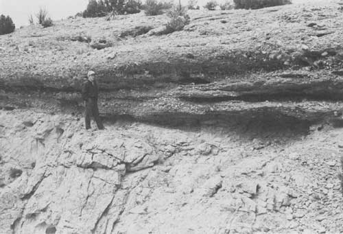
| FIGURE 22.—Basal conglomerate of the Browns Park Formation resting unconformably on truncated Glen Canyon Sandstone, in the canyon of the Little Snake River at the east end of the Uinta Mountains. Pebbles and small cobbles are embedded in a matrix of well-cemented, poorly sorted, coarse-grained sandstone. Exposure is about 50 m above river level. Compare with figure 20. |
Twelvemile Mesa correlates geomorphically across the Yampa River with Klauson Pasture (Dyni, 1980), and the capping conglomerates on these surfaces are virtually identical. But the deposit on Twelvemile Mesa passes beneath the Browns Park Formation to the east and south, further proving that the Browns Park is stratigraphically higher and younger. According to J. R. Dyni (oral commun., 1981) the conglomerate beneath the Browns Park on Twelvemile Mesa is discontinuous. Dyni (1980) suspected pre-Browns Park (pre-"upper sandstone unit") folding in the conglomerate. It seems clear that the conglomerate on Twelvemile Mesa, as well as on Klauson Pasture, was deformed and dissected before the Browns Park Formation was deposited. In the broad downwarp between Vermillion Creek and Maybell, however, where the Bishop was lowered enough tectonically for subsequent burial, the Browns Park was deposited directly on it. Elsewhere the Browns Park lies in valleys tens to hundreds of meters lower than nearby remnants of Bishop Conglomerate.
| <<< Previous | <<< Contents >>> | Next >>> |
pp/1356/sec6.htm
Last Updated: 09-Nov-2009