
|
Geological Survey Professional Paper 1365
Ice Volumes on Cascade Volcanoes: Mount Rainier, Mount Hood, and Mount Shasta |
RESULTS FROM FOUR CASCADE VOLCANOES
(continued)
THREE SISTERS
In this report, the name Three Sisters collectively refers to the North Sister, Middle Sister, and South Sister, three volcanic cones located in an extensive volcanic region about 30 miles west of Bend, Oreg. The Three Sisters have a total ice and snow volume of 5.6 billion ft3, as seen in table 4.
TABLE 4.—Areas and volumes of glacier ice and snow on Three Sisters
[Methods of determination; A, volume estimated by using area correlation; M, glacier thickness measured by ice radar. Because total glacier areas are required in the application of the volume estimation method, volumes are available by total glacier. Area measured in ft2 (x 106); volume measured in ft3 (x 109).—in the area column means no ice or snow present for glaciers at that elevation, and in the volume column it means volume by elevation not determined for that glacier]
| Altitude Interval |
||||||||||||||
| Drainage Area | Glacier or snow patch |
6,000-7,000' | 7,000-8,000' | 8,000-9,000' | 9,000-10,000' | 13,000-14,162' | Area total |
Volume total |
Method of determination | |||||
| Area | Volume | Area | Volume | Area | Volume | Area | Volume | Area | Volume | |||||
| Squaw Creek | Snow patches | 0.1 | -- | 4.7 | -- | 1.5 | -- | 0.1 | -- | -- | -- | 6.4 | 0.3 | A |
| Linn | -- | -- | -- | -- | .6 | -- | -- | -- | -- | -- | .6 | .03 | A | |
| Villard | -- | -- | -- | -- | .1 | -- | .4 | -- | -- | -- | .5 | .02 | A | |
| Thayer | -- | -- | 1.1 | -- | .6 | -- | -- | -- | -- | -- | 1.7 | .1 | A | |
| Hayden | -- | -- | .7 | .07 | 6.8 | .6 | .3 | .009 | -- | -- | 7.8 | .6 | M | |
| Diller | -- | -- | 2.9 | .2 | 4.2 | .3 | -- | -- | -- | -- | 7.1 | .5 | M | |
| Carver | -- | -- | 1.9 | -- | 1.6 | -- | -- | -- | -- | -- | 3.5 | .2 | A | |
| Prouty | -- | -- | .3 | .03 | 7.9 | .4 | 2.3 | .1 | .004 | .001 | 10.5 | .7 | M | |
| Collier | -- | -- | -- | -- | .4 | .004 | -- | -- | -- | -- | .4 | .004 | M | |
| Subtotal | .1 | -- | 11.6 | -- | 23.7 | -- | 3.1 | -- | .004 | -- | 38.5 | 2.5 | ||
| Fall Creek | Snow patches | -- | -- | 1.3 | -- | 1.4 | -- | .4 | -- | -- | -- | 3.1 | .1 | A |
| Lewis | -- | -- | -- | -- | 1.6 | -- | 2.6 | -- | -- | -- | 4.2 | .3 | A | |
| Subtotal | -- | -- | 1.3 | -- | 3.0 | -- | 3.0 | -- | -- | -- | 7.3 | .4 | ||
| Separation Creek | Snow patches | -- | -- | .6 | -- | 1.5 | -- | .6 | -- | -- | -- | 2.7 | .1 | A |
| Clark | -- | -- | -- | -- | 3.0 | -- | -- | -- | -- | -- | 3.0 | .2 | A | |
| Lost Creek | -- | -- | 1.5 | .05 | 4.1 | .4 | .2 | .003 | -- | -- | 5.8 | .4 | M | |
| Crater | -- | -- | -- | -- | -- | -- | -- | -- | 1.1 | .07 | 1.1 | .06 | M | |
| Eugene | -- | -- | -- | -- | -- | -- | 1.0 | .006 | -- | -- | 1.0 | .05 | A | |
| Skinner | -- | -- | 1.7 | -- | 1.4 | -- | -- | -- | -- | -- | 3.1 | .2 | A | |
| Irving | -- | -- | 3.4 | -- | .6 | -- | .1 | -- | -- | -- | 4.1 | .3 | A | |
| Subtotal | -- | -- | 7.2 | -- | 10.6 | -- | 1.9 | -- | 1.1 | -- | 20.8 | 1.3 | ||
| White Branch | Snow patches | -- | -- | 3.1 | -- | 1.9 | -- | .3 | -- | -- | -- | 5.3 | .3 | A |
| Renfrew | -- | -- | .3 | -- | 5.2 | -- | .5 | -- | -- | -- | 6 | .4 | A | |
| Collier | -- | -- | 3.1 | .2 | 7.9 | .5 | .4 | .005 | -- | -- | 11.4 | .7 | M | |
| Subtotal | -- | -- | 6.5 | -- | 15.0 | -- | 1.2 | -- | -- | -- | 22.7 | 1.4 | ||
| Total | .1 | 26.6 | 52.3 | 9.2 | 1.1 | 89.3 | 5.6 | |||||||
Four major streams drain the Three Sisters. Separation Creek and White Branch drain the west sides of the mountains and empty into the McKenzie River. Squaw Creek drains most of the Three Sisters' east side and empties into the Deschutes River, after flowing through the town of Sisters. Forty-three percent of the total surface area of snow and ice is in the Squaw Creek watershed. Fall Creek drains the southeastern part of South Sister, where flank eruptions have occurred in postglacial time. Five miles from South Sister it empties into Sparks Lake, which has no surface outlet.
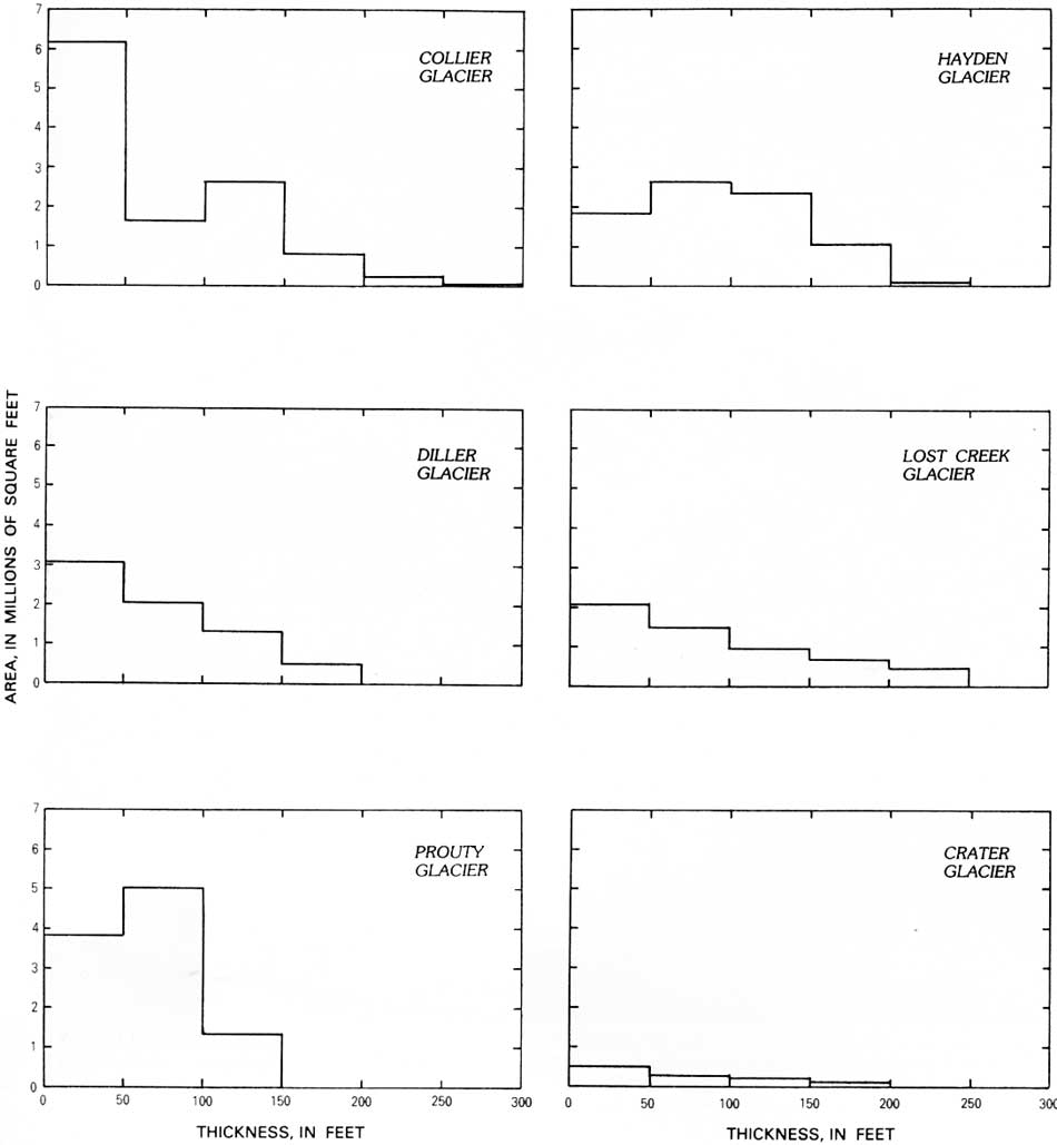
Radar measurements were made on the five major glaciers on the Three Sisters: Hayden, Diller, Collier, Prouty, and Lost Creek Glaciers. As seen in table 4, Collier Glacier (in the Squaw Creek and White Branch drainage areas) is the largest, with a surface area of 11.8 million ft2, a volume of 0.7 million ft3, and the greatest ice thickness at 300 ft. Plate 4 displays basal contours and plate 5 displays isopachs for the measured glaciers.
Volcanism in the Three Sisters region is varied in origin and type, with eruptions predating and postdating the eruption of Mount Mazama about 6,800 years B.P. (Wozniak and Taylor, 1981, p. 61). The larger relief features consist of three cones more than 10,000 ft in altitude—North, Middle, and South Sisters, which erupted in pre-Holocene time—and the smaller cones of Broken Top (pre-Holocene) and Bachelor Butte (Pleistocene to Holocene time, fig. 16). More recently, basalt has flowed over extensive regions north and south of the Three Sisters. A rhyodacitic flank eruption on the south side of South Sister is the most recent activity on the Sisters cones.
|
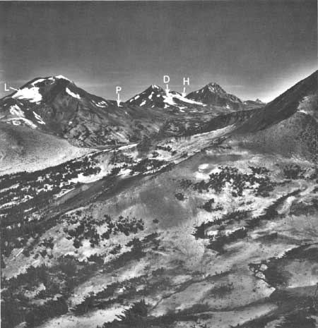
| FIGURE 16.—South, Middle, and North Sisters and the slope of Broken Top, Oreg., as seen (left to right) from the southeast. Lewis (L) and Prouty (P) Glaciers are visible on slopes of South Sister. Diller (D) and Hayden (H) Glaciers are visible on right flank of Middle Sister. Most recently erupted lava of 2,000 to 3,000 years ago is visible on the south flank of South Sister. (U.S. Geological Survey photograph by Robert Krimmel on August 18, 1981.) |
The lack of widespread mudflow and pyroclastic deposits from the most recent summit eruptions on South Sister indicates that these eruptions may have occurred during late Wisconsin time when an extensive ice cover surrounded the cone. Though no direct geologic evidence exists to indicate large-scale glacier melting during past eruptions, there is evidence that some late Holocene flank eruptions were accompanied by small lahars, which were probably aided by rapid snowmelt (W. E. Scott, U.S. Geological Survey, written commun., May 18, 1983).
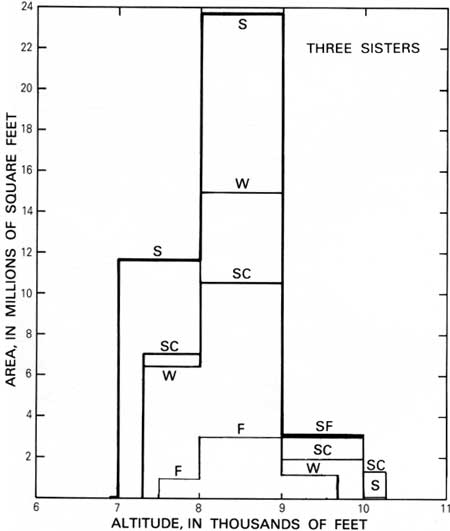
Regional eruptive patterns during the Holocene indicate that future rhyodacitic eruptions accompanied by small pyroclastic flows and tephra could occur on the south flank of South Sister in the presence of seasonal snow cover and glacier ice. Figure 17 illustrates that 47 percent of the area covered by snow and ice is on the South Sister. In this drainage basin are the Prouty and Lewis Glaciers, with a total volume of 0.8 billion ft3. Basaltic eruptions north and south of the Sisters could pose an additional hazard if erupted onto thick snow pack. Figures 18 and 19 show ice volumes for radar-measured glaciers, and ice areas by drainage as a function of altitude.
|
| FIGURE 17.—Areas of ice and snow in the Three Sisters drainage basins as a function of altitude. Drainage basins listed are as follows; Fall Creek (F), Separation Creek (S), Squaw Creek (SC), and White Branch (W). |
|
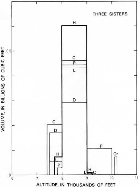
| FIGURE 18.—Ice volumes of measured glaciers of the Three Sisters volcanoes as a function of altitude. Glaciers listed are as follows: Collier on North Sister (C), Crater on South Sister (Cr), Diller on North Sister (D), Hayden on North Sister (H), Lost Creek on South Sister (L), and Prouty on South Sister (P). |
|
| FIGURE 19.—Areas of ice for selected thickness intervals on radar-measured glaciers of the Three Sisters volcanoes. Values are derived from isopach maps. (click on image for an enlargement in a new window) |
More information on the geology of the Three Sisters volcanic region is available in the recent report by Taylor (1981).
| <<< Previous | <<< Contents >>> | Next >>> |
pp/1365/sec3b.htm
Last Updated: 28-Mar-2006