|
Geological Survey Professional Paper 17
Preliminary Report on the Geology and Water Resources of Nebraska West of the One Hundred and Third Meridian |
GEOLOGY
GENERAL GEOLOGY OF NEBRASKA.
The geology of Nebraska presents broad structural features which it is necessary to outline before a clear idea can be given of the local relations in the western portion of the State. The principal formations which outcrop are extensive sheets of sands and clays of Cretaceous, Tertiary, and Pleistocene age, underlain by Carboniferous limestone, which outcrops in the southeastern counties. In the map, Pl. IX, an attempt has been made to indicate the present state of knowledge of the distribution of the principal formations. It is based on a large number of new data from personal observations. In the cross section, Pl. X, are shown the principal structural relations of the formations. The following list sets forth their order, age, and salient features:
Table of geologic formations in Nebraska.
| Age. | Name. | Predominant characters. | |
| Pleistocene | Alluvium | Sand, loam, and gravel in valleys; talus on slopes. | |
| Sand hills | Sand mainly in dunes, due to wind action. | ||
| Loess | Fine sandy loam of pale brownish-buff color. | ||
| Drift | Bowlder clays and sands of glacial origin, and sandy clays, sands, and pebble beds. | ||
| Equus beds | Gray sands. | ||
| Neocene | Ogalalla formation (Pliocene). | Loup Fork beds. | Calcareous grit, sandy clay, and sand. |
| Arikaree formation (Miocene). | Gray sand with beds of pipy concretions. | ||
| Gering formation (Miocene). | Coarse sands, soft sandstone, and conglomerate. | ||
| Eocene (Oligocene). | Brule clay | White River group. | Pinkish clays, hard, and snore or less arenaceous. |
| Chadron formation | Pale greenish-gray sandy clay. | ||
| Cretaceous. | Laramie formation | Yellowish and greenish sandstone and shale. | |
| Pierre clay | Dark-gray clay or soft shale. | ||
| Niobrara formation. | Montana group. | (Chalky limestone and shale. | |
| Benton shale | Dark-gray or black shale or clay. | ||
| Dakota sandstone | Brown sandstone. | ||
| Carboniferous | Permian limestone | Buff limestones and shales. | |
| Cottonwood limestone | Massive limestone of light color. | ||
| Wabaunsee formation | Limestones, shales, sandstones, and thin coal beds. | ||

|
| PLATE IX.—PRELIMINARY GEOLOGIC MAP OF NEBRASKA, BY N.H. DARTON. (click on image for a PDF version) |

|
| PLATE X.—CROSS SECTION FROM ROCKY MOUNTAINS TO OMAHA, ACROSS NEBRASKA. (click on image for a PDF version) |
Alluvium.—Owing to the softness of the Cretaceous and Tertiary formations which constitute the surface of the greater part of Nebraska, the river valleys are wide, and they are floored to a greater or less depth with deposits of alluvial materials brought by the streams at various stages of their development. The largest alluvial areas are along the valley of Platte River, which has a width of 15 miles in the central portion of the State. Southwest of Omaha, where the river crosses the hard rocks of the Carboniferous which rise in the eastern part of the State, its valley is narrowed greatly. The valleys of Republican, Blue, Nemaha, the Loups, Elkhorn, and Niobrara rivers contain alluvial deposits of moderate width, and all the smaller valleys contain local alluvial materials to a greater or less degree. The deposits are mainly sands and loams, intermixed with pebbles in some localities, and occasionally associated with local beds of clay and accumulations of peat and diatomaceous earth.
Sand dunes.—A wide area of central Nebraska is occupied by wind-blown sands, constituting the great sand-hill district. Its area is about 24,000 square miles. The sand in this district is blown into high ridges and hills, but there are numerous intersecting valleys of various sizes which constitute a moderate proportion of the area. There are local accumulations of wind-blown sand of considerable extent along the valley of Platte River south of Kearney, along Loup River north of Grand Island, along the south slopes of the North Platte Valley west of the one hundred and third meridian, and in Chase, Perkins, and Lincoln counties.
The sands were largely derived from the Arikaree formation, but it is also probable that they are in part the remains of formations of early Pleistocene age or an extension of the Equus deposits or the loess.
Loess.—The loess occupies more than one-third of the area of Nebraska, usually giving rise to level plains, which it underlies to a thickness of about 100 feet. The widest area is in the table-lands south of Platte River. To the northwest it is overlapped by the sand hills, but it extends far north in the eastern portion of the State and to the southwest to Dundy County. On the divides it is limited on the west by the highlands in Chase and Hayes counties, but extends farther up the valley of Republican River. The western margin in Deuel County is marked by high ridges of Tertiary formations, which constituted a shore against which the loess was deposited. The material of the loess is a fine, sandy loam, somewhat calcareous, and chiefly of a pale brownish-yellow color. Occasionally streaks of sand and old soil are found, and some portions are slightly more argillaceous than usual. The deposit is of a remarkably uniform texture, compact, but perfectly soft. Much of the water falling upon its surface is absorbed, but on steep slopes there is rapid excavation wherever a rivulet gets a fair start. In the lower part of the formation, possibly underlying it, and entirely separate, are deposits of volcanic ash, usually mixed with more or less flue sand, but often consisting almost entirely of fine shreds of volcanic glass.
The thickness of the loess is variable, but over a wide area of the central portion of the State it averages 100 feet. It has similar thickness at most points near Missouri River. In the region of drift hills about Lancaster County the thickness varies from 20 to 100 feet.
The loess is the product of a relatively long period of deposition at the close of Glacial time. In the wide area in central Nebraska it was deposited by Platte River at a stage when the river spread as a wide plexus of streams over the divide south of its present course. The deposits extend far up the slopes of the high drift hills about Lancaster County, and probably the greater portion of this area was originally entirely covered by earlier loess. Missouri River spread a wide mantle of loess across the eastern margin of the State, and in the later stages of deposition this loess was deposited in the lower, wider valleys among the drift hills.
Drift.—The glacial drift covers the greater part of Nebraska east of longitude 97° 30'. It is a product of the Kansan stage of the Glacial epoch, when a lobe of the glacier extended to Kansas River. Extending west from the glacial-drift border there is a thin sheet of sands and gravels, which is continuous under the loess to beyond the one hundred and second meridian. The greater portion of the glacial drift consists of blue and gray bowlder clays. There are locally included sand beds, and in some localities extensive deposits of bowlders. The pink Sioux quartzite, often in very large masses, is a conspicuous feature of the drift, but there are many other rocks associated with it. Wide areas of clay surfaces with only a few scattered bowlders occur, and there are other areas of light sandy clays, particularly on the higher level lands, which appear to be loess merging into the glacial drift. The drift is thick in Lancaster and Gage counties. It thins rapidly toward Missouri River, where it is usually represented by a thin layer of gravel underlying the thick mantle of loess. The thin drift sheet, which extends far west from the glacial-drift margin under the loess, is usually sand or sandy clay, commonly of pinkish color. To the north it is often represented by coarse sand, and to the west it merges into a gravel bed. Pebbles of a great variety of rocks, apparently mainly of Rocky Mountain origin, occur throughout. The westernmost extension of this deposit observed was in the table-land north of Big Spring, in Deuel County, where it is represented by a bed of gravel 20 feet thick underlying 100 feet of loess.
Ogalalla formation.—Extending from Kansas and Colorado far into Nebraska there is a calcareous formation of late Tertiary age to which I wish to apply the distinctive name Ogalalla formation. It is a portion, if not the whole, of the deposit which in Kansas and southward has been called the "Mortar beds," "Tertiary grit," and other names. It has been regarded as a portion of the Loup Fork formation. It is extensively developed in the western part of Nebraska, in the region about Lodgepole Creek and in the area between Platte River and the Kansas line west of the ninety-ninth meridian. It thins out in Banner County and in the central part of Cheyenne County, giving place to the northwest to an underlying member of the Loup Fork series. It crosses North Platte River in the western part of Deuel County, but its limits in the central and northern portions of the State have not been ascertained. It appears to underlie a portion at least of the great sand-hill district. In its typical development the Ogalalla formation is a calcareous grit or soft limestone containing a greater or less amount of interbedded and intermixed clay and sand, with pebbles of various kinds sprinkled through it locally, and a basal bed of conglomerate at many localities. In places it merges into a light-colored sandy clay, generally containing much carbonate of lime in streaks or nodules. The pebbles it contains comprise many crystalline rocks, which appear to have come from the Rocky Mountains. These pebbles accumulate on the disintegrating surfaces of the Ogalalla formation, and they appear to have contributed largely to the gravel bed underlying the loess to the east.
Arikaree formation.—In the western portion of Nebraska there is found underlying the Ogalalla formation a series of sands of gray color everywhere characterized by layers of dark-gray concretions which often have tubular form. This formation enters the State from Wyoming, and has been found to thin out under the Ogalalla formation in the eastern portion of Banner County. It has a thickness of 400 feet in Scotts Bluff County and of 500 feet in Sioux and Dawes counties, the amount increasing as the Arikaree displaces the Ogalalla formation northward. It is extensively exposed along Niobrara River, apparently to the east of Valentine, and it is seen occasionally along the western edge of the sand-hill district, but it has not yet been distinctly recognized in the region drained by the Loup Forks or along Platte River east of Cheyenne County. In its upper portion are beds containing the large Dæmonelix of Barbour. The name Arikaree has been applied to the deposit for the reason that the Arikaree Indians were at one time identified with the area in which it is most largely developed. It is distinctly separated from the Ogalalla formation by erosional unconformity and overlap, which is clearly illustrated in the western portion of the State. The formation includes a large amount of volcanic ash, as a general admixture in its sediments as well as in beds of considerable extent and thickness. It also contains a number of channels filled with conglomerate, which will be described in detail later. (See p. 28.)
Gering formation.—This formation, like the Arikaree and Ogalalla formations, was differentiated in the summer of 1897. It consists of laminated, massive, and cross-bedded, light-gray, mainly coarse sands and soft sandstone at the base of the Arikaree formation. The character of the deposits and the abrupt change from the typical Arikaree formation have afforded a basis for the discrimination of this formation. It has been found in Scotts Bluff, Banner, Cheyenne, Sioux, and Dawes counties, and locally attains a thickness of 200 feet. It often comprises two members, more or less distinctly separated by unconformity, and it lies unconformably on the Brule clay. The materials are sands, which vary from coarse to fine, and they are often sufficiently lithified to be classed as soft sandstone. At the base there is usually more or less conglomerate of local origin. In some districts the formation thins out and appears to be entirely absent, but possibly in this case it has simply lost its distinctive characteristics, so that it would be overlooked as the lower portion of the Arikaree formation. In some cases where the formation is thought to be absent there is seen to be unconformity below the Arikaree beds.
Brule clay.—The White River beds in their extension from South Dakota into Nebraska present some differences in stratigraphic range and relations. They expand considerably and include, at their top, beds which appear not to be represented in the typical regions. Accordingly, to afford distinct definitions for the members in Nebraska, I have introduced the designation Brule clay, and separated the underlying Titanotherium beds as the Chadron formation.
The Brule clay consists mainly of a hard, sandy clay, of pale-pink color. Its thickness averages about 600 feet in the vicinity of the Wyoming line, but the amount diminishes greatly eastward. In the vicinity of the one hundred and third meridian in the northwest corner of the State it has a thickness of 320 feet. The formation has not been recognized east of longitude 101° 30', where it appears to sink beneath the surface in the Platte Valley. It extends far to the northeast in South Dakota.
Chadron formation.—Lying under the Brule clays there is a thin sheet of light-greenish, sandy clay, the basal member of the White River series, known as the "Titanotherium beds." Its outcrops extend in a narrow zone across the northern portion of the State, and it is apparently exposed along North Platte River near the Wyoming line. It is known to underlie portions of Colorado and South Dakota, but it appears not to extend far eastward in southern Nebraska, for it is absent along Republican River. It is reported that Titanotherium remains were obtained near Longpine, but nothing has been learned of the relation and extent of the beds in that locality.
Laramie formation.—The Laramie formation extends under the southwestern corner of Nebraska, but probably to no great distance. Its only exposures are along the State line on Horse Creek west of Caldwell and in another small area a few miles southwest of that place, where it rises in it low mound under the Brule clay. The rocks are yellowish and greenish sandstones and clay.
Pierre clay.—All of Nebraska west of the ninety-eighth meridian is underlain by the Pierre clay. Its surface outcrops are in the lower portion of the Niobrara Valley, the Republican Valley, and the extreme northwest corner of the State, but it is probable that careful search will reveal outcrops in the valley of the Platte River in the vicinity of the ninety-sixth meridian. The formation is a thick mass of dark gray or bluish clay or soft shale. Its thickness is probably at least 2,000 feet in the central-western portion of the State.
Niobrara and Benton formations.—Underlying the Pierre clay there is a series of chalky limestones known as the Niobrara formation and shales known as the Benton formation. They have a thickness of about 450 feet to the east, but thicken to the west. At the base there are about 200 feet of dark shales, overlain by slabby limestones of the Greenhorn formation containing Inoceramus, which are followed by a series of shales with few thin sandy layers, and at the top the Niobrara formation with its chalky deposits characterized by thin hard beds filled with Ostrea congesta. The formations cross the eastern portion of the State, and underlie all of the area west of the vicinity of the ninety-seventh meridian, but they are so deeply buried under drift and loess that outcrops are rarely visible. The most extensive exposures are along Missouri River, extending from near the ninety-seventh to the ninety-ninth meridian, and along the Republican Valley from Alma to near Superior. The formations are exposed at intervals across the eastern portion of the State in each of the larger valleys and some of the branches. The more notable of these small outcrops are at Genoa, north of Germantown, near Crete, at Pleasant Hill, and in Beaver Creek north of Dorchester. There is an exposure of dark shales under some ledges of Greenhorn limestone in Big Blue River at Milford, which are Benton. During the summer of 1897 upper Benton and Niobrara beds were discovered rising in a prominent anticline along White River in the vicinity of Beaver and Alkali creeks, in the northwest portion of the State.
Dakota sandstone.—The Dakota sandstone underlies nearly all of Nebraska, and outcrops in a narrow belt extending from Missouri River to the vicinity of the ninety-seventh meridian. It is gray or brown sandstone, containing streaks of clay of greater or less size, and its aggregate thickness is about 400 feet, including a basal series of Lower Cretaceous sandstone. Its surface passes under the Benton shales, and, owing to the low westerly dip and the gradual increase in altitude of the State to the west, the Dakota sandstone is soon deeply buried. In the central portion of the State it probably lies over 2,500 feet below the surface. In its outcrop area it is heavily covered by drift and loess, but there are numerous exposures in the banks along Missouri River in Dakota County—which was the type locality of the formation—along Platte River from Ashland nearly to Plattsmouth, along the valley of Salt Creek and its branches, at Beatrice, and in the valley of Little Blue River in Jefferson County. The formation carries the great artesian-water supplies, which are so extensively developed by wells in eastern South Dakota and on lowlands in Knox, Cedar, and Boyd counties, Nebraska.
Carboniferous formations.—The Carboniferous limestones, shales, and sandstones underlie all of Nebraska, rising to the north and northwest about the Black Hills and on the slopes of the Rocky Mountains, as shown in Pl. X and fig. 21, on page 46. The outcrops in eastern Nebraska are in Douglas, Sarpy, Cass, Lancaster, Otoe, Gage, Johnson, Pawnee, Nemaha, and Richardson counties. The rocks are hard and would give rise to more prominent features in this region if it were not for the heavy covering of glacial drift and loess. As it is, the exposures constitute cliffs along Platte River from Ashland to Plattsmouth, and thence at intervals along Missouri River to the southeast corner of the State, and occur in scattered outcrops along the valleys of Big Blue, Nemaha, and Little Nemaha rivers and Weeping Water, Turkey, and Southeast Salt creeks and their branches.
The rocks of the Carboniferous period in this region comprise formations of Permian and Upper Coal Measure or Pennsylvanian age. The Permian outcrops are probably restricted to the valley of Big Blue River from Beatrice southward. The rocks are mainly magnesian limestones of light color with interbedded shales. They are extensively exposed south of Beatrice, at Rockford, Blue Springs, Wymore, and Holmesville. The other Carboniferous members appear to comprise the Cottonwood and Wabaunsee formations of the Kansas geologists. They consist of limestones, shales, and sandstones, which contain thin coal beds in some localities. Professor Prosser has made a preliminary examination of the Carboniferous of Nebraska, and identifies as Wabaunsee the exposures about Peru, Aspinwall, Nebraska City, Auburn, Tecumseh, Dunbar, Nehawka, Weeping Water, and in the long section along Platte River near Louisville. The Cottonwood limestone, a massive bed full of Fusulina, was recognized west of Auburn about Glen Rook and Johnson, and the same beds extend over the higher lands of western Richardson and Pawnee counties.a In the deep borings which have been made at various points in the southeastern corner of the State it has been found that the Carboniferous formations have a total thickness of about 1,200 feet, of which about 200 feet are Permian. In the deep well at Lincoln the lower limestones were found to be 835 feet thick and underlain by 800 feet of magnesian limestones of undetermined, but probably in part Devonian, age; these, in turn, by limestone apparently of the Trenton formation, extending from 1,813 to 1,947 feet; a supposed representative of the St. Peter sandstone, having a thickness of 61 feet; 113 feet of magnesian limestones, supposed to be the Magnesian limestone of the Mississippi Valley; and a red sandstone. extending from 2,121 to 2,192 feet, thought to be Cambrian. This was found to lie on a red quartzite—penetrated for 270 feet—supposed to be an extension of the Sioux Falls quartzite of Algonkian age, which is underlain by granite rocks northward.
aJour. Geol., vol. 5. 1897, pp. 1-16.
There are possibly two other formations underlying portions of Nebraska but not reaching the surface. To the northwest there is doubtless an extension of the Juratrias red sandstones and greenish sands and clays which are exposed so conspicuously about the margin of the Black Hills, only 55 miles distant from the northwest corner of the State. They lie between the Carboniferous limestone and the Dakota sandstone, as shown in the sections, Pl. X and fig. 21, on page 46. They are absent in the eastern portion of the State, but in part are extensively developed in Kansas.
The other formation which may extend into Nebraska is the Laramie sandstone, which lies between the Pierre shale and the Tertiary formations in northeast Colorado. It would not be surprising if this formation should be found to underlie a portion of extreme western Nebraska, but it is known to be absent in the Republican Valley as far west as Dundy County, and in the region north of Pine Ridge, in Sioux and Dawes counties.
GEOLOGY OF THE REGION WEST OF THE ONE HUNDRED AND THIRD MERIDIAN
GENERAL RELATIONS.
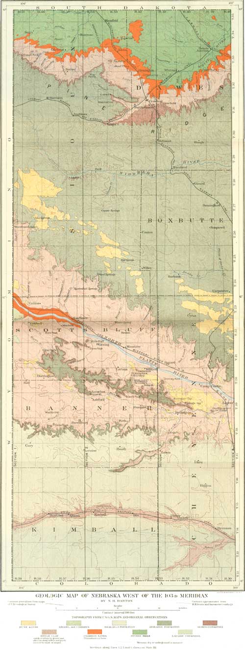
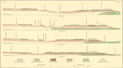
The formations of this region comprise alluvium and dune sands and Ogalalla, Arikaree, Gering, Brule, and Chadron formations, lying on a thick mass of Pierre clay and the northeastern edge of the Laramie formation. The loess and drift are not present. The distribution of these formations, except the alluvium, is shown on the geologic map, Pl. XI. Their structural relations are shown in the series of cross sections, Pl. XII. The older formations underlying the Pierre shale do not reach the surface nearer than the southern slopes of the Black Hills, where, as shown in fig. 21, they rise in regular succession.
|
| PLATE XI.—GEOLOGIC MAP OF NEBRASKA WEST OF THE 103D MERIDIAN. (click on image for a PDF version) |
|
| PLATE XII.—GEOLOGIC SECTIONS ACROSS NEBRASKA WEST OF THE 103D MERIDIAN, LOOKING WEST ALONG THE LINES 1, 2, 3, AND 4, ON PLATE XI. (click on image for a PDF version) |
The relations of the formations, as shown in Pls. XI and XII, are relatively simple. There is a broad, thick sheet of Brule clay, underlain by a thin layer of Chadron formation, lying on the irregular surface of the Pierre clay, which outcrops in the region north of the foot of Pine Ridge. The Gering formation is a thin sheet of coarse sand and soft sandstone which lies on the Brule clay, mainly in channels. It appears to outcrop continuously along the northern front of Pine Ridge, about halfway up the slope; it has been recognized at one point on the north slope to the valley of North Platte River. It is extensively developed in wide channels in the ridge lying next south, but it is absent in the table-land south of Pumpkinseed Creek, except probably in a small outlier exposed far up the valley of Lawrence Fork. The Arikaree formation, consisting of fine sands with dark-gray pipy concretions, constitutes the crest of Pine Ridge and the table-land extending north of the Platte Valley. It also heavily caps the ridge lying between the valleys of the Platte and the Pumpkinseed, but it thins rapidly to the south and east in the high table-land south of the Pumpkinseed Valley, and dies out east of the mouth of Lawrence Fork. The Ogalalla formation, consisting mainly of light-colored pebbly sands cemented by carbonate of lime, covers the table-land south of the Pumpkinseed Valley, lying on the Brule clay to the east and on a thickening wedge of the Arikaree formation to the west. Outlying masses cap certain high points on the ridge north of the Pumpkinseed Valley, and it may possibly be present on the higher portions of the table-land north of Platte River, together with outliers of the Equus beds. The larger sand-hill areas are on the table-land north of the valley of Platte River. but smaller areas are found in both Platte and Pumpkinseed valleys. Alluvium, which is not represented on the map and sections, floors portions of the valleys and merges upward into wash and local talus on the slopes of the hills.
ALLUVIAL FORMATIONS.
On the lower slopes adjacent to North Platte River and along the other streams of the region there has been deposited a greater or less thickness of materials brought by the streams from the higher lands. In the valley of Platte River there is a wide zone of bottom lands bordering each side of the river, on which is found a mantle of alluvium, several feet thick, lying on the older formations in which the river valley was cut. The materials consist mainly of sandy loams with occasional coarse constituents. On the adjoining terraces above is found a mantle of sand and gravel, deposited when the river was much higher than it is now. The gravels contain many rocks from the Rocky Mountains, comprising granites of various kinds, quartzites, chalcedonic vein stones, often of considerable beauty, and a small variety of eruptive rocks. The materials vary in size from coarse sand to moderately large bowlders. The coarser deposits give rise to long narrow ridges or lines of knobs, while the materials of intermediate coarseness cover terraces, which in some cases extend back from the river bottom for several miles. It is claimed that small showings of gold have been panned from these formations at several localities. In the valleys of Lodgepole and Pumpkinseed creeks and White River the alluvial materials are mainly in narrow belts of bottom lands, and consist chiefly of local materials. In the valley of Pumpkinseed Creek, however, there are at higher levels extensive deposits of coarser gravels containing rocks from the Rocky Mountains similar to those along Platte River. It is probable that this river at one time sent a branch stream through the wide depression now occupied by Pumpkinseed Creek and spread the gravel on the high terraces. At that time the ridge lying north of Pumpkinseed Creek was an island in the midst of a wider Platte River, but the valleys were not so deep as they are now. Nearly every stream flowing out of the high lands has brought down more or less alluvial material in the shape of sand or local gravel, which merges into the alluvial deposits of the larger valleys. There is also on nearly all of the slopes adjoining the valleys a talus or wash of sand and clays from above, which often covers the underlying formations to considerable thickness.
None of the alluvial formations have been shown on the geologic map, Pl. XI, because some of their relations are too intricate for accurate representation on a small scale.
SAND DUNES.
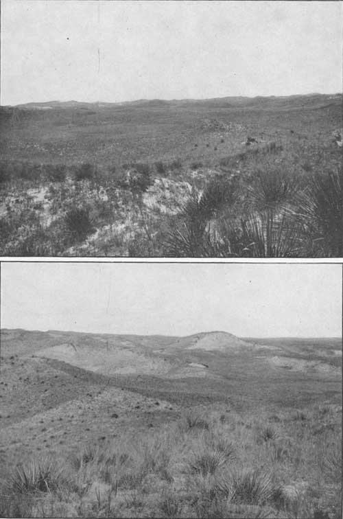
The sand hills are a distinct geologic formation in this region, in part contemporaneous with the alluvial deposits along the bottoms of river valleys. They are in process of formation and modification by the strong winds, and are in a measure still moving to the southeast. Two typical views of the sand-hill region are reproduced in Pl. XIII. The sand now constituting the sand hills was derived mainly from the Arikaree formation, having been carried over the plains by the wind and accumulated about the obstructions. The manner in which the sand is blown away is well illustrated in Pl. XVIII, A. The sand-dune areas in the North Platte Valley no doubt derived a portion of their material from the sand banks and other alluvium of the river which have been blown by the wind and lodged against obstructions. This is particularly well illustrated in the area which abuts against Chimney Rock. The small areas about Caldwell and Dorrington and at other points in the Pumpkinseed Valley are probably of similar origin, except in a few cases where local sources have supplied the materials.
|
| PLATE XIII.—A (top), B (bottom), TYPICAL SANDHILLS IN WESTERN CHEYENNE COUNTY, NEBR. A Leeward side, looking west; B, windward side, looking southeast, showing blowouts. |
OGALALLA FORMATION.
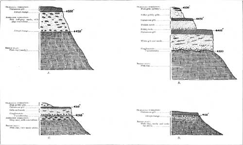
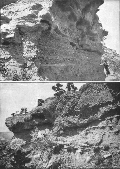
The Ogalalla formation is the uppermost division of the Tertiary deposits of this region. It constitutes the high table-lands on both sides of the Lodgepole Valley, and caps the several small high summits about Wildcat Mountain, northwest of Ashford. As before explained, it is in the main the extension of the "Tertiary grit," "Magnesia," or "Mortar beds" of the Kansas geologists. It consists of an impure calcareous grit, or sand cemented with carbonate of lime. At its base there are often beds of conglomerate, with pebbles consisting mainly of gray sandstone or limestone. Throughout its mass there are scattered pebbles of crystalline rocks from the Rocky Mountains, streaks of pebbly sand, and thin ledges of sandstone. The harder calcareous beds are of white or cream color, and outcrop in irregular cliffs along the slopes of depressions. Some softer intercalated beds of sandy character are of light-pinkish color. The formation has a relatively level surface, which constitutes the floor of the high table-land of Kimball County and the southern portion of Banner and Cheyenne counties. When the rock disintegrates on the surface a greater or less accumulation of sand and scattered pebbles remains, often constituting a soil of greater or less thickness. This soil, when irrigated, usually proves to be very productive. The general thickness of the Ogalalla formation varies from 150 to 300 feet, the greater amount being along the Wyoming line, in the northwest corner of Kimball County. As the surface has been more or less eroded, the original thickness is unknown. The altitude of its base is 4,100 feet south of Lapeer, 5,200 feet west of Harrisburg, 4,300 feet near Bronson, 5,100 feet west of Bushnell, and 5,000 feet on Wildcat Mountain. The wider relations of the Ogalalla formation to the older Tertiary formations are shown in the cross sections in Pl. XII. In these sections it will be seen that in Lodgepole Valley the Ogalalla formation lies directly on the Brule clay; along the south side of the Pumpkinseed Valley it lies on the Brule clay to the east, and then on the Arikaree formation, which comes in and gradually thickens to the west. An exposure of its basal conglomerate is shown in Pl. XIV. At this exposure the Arikaree beds are thin, as shown in Pl. XV, C. It is everywhere clearly separated below by erosional unconformity, and its base is usually a shore deposit of pebbles of gray siliceous and calcareous rocks. In the outliers about Wildcat Mountain the thickness is about 50 feet, and the formation lies on a thick mass of Arikaree formation, from which the basal conglomerate is very distinctly separated by an unconformity. The relations in this vicinity are shown in fig. 1.

|
| FIG. 1.—Columnar section of formations exposed in Wildcat Mountain and vicinity, Banner County, Nebr. |
|
| PLATE XIV.—A (top), CONGLOMERATE AT BASE OF OGALALLA FORMATION 5 MILES SOUTH-SOUTHEAST OF REDINGTON, CHEYENNE COUNTY, NEBR. The conglomerate lies on Arikaree formation. B (bottom), CONGLOMERATE IN ARIKAREE FORMATION 3 MILES DUE SOUTH OF LARISSA, SCOTTS BLUFF COUNTY, NEBR., LOOKING NORTHWEST. |
Some typical sections illustrating the relations of the formations are given in Pl. XV. There may possibly be a small area of Ogalalla formation to the east on portions of the table-land north of North Platte River, but it was not distinguished. A few vertebrate remains were collected in this formation, and it was found to contain the smaller Dæmonelix forms in considerable abundance in some localities.
ARIKAREE FORMATION.
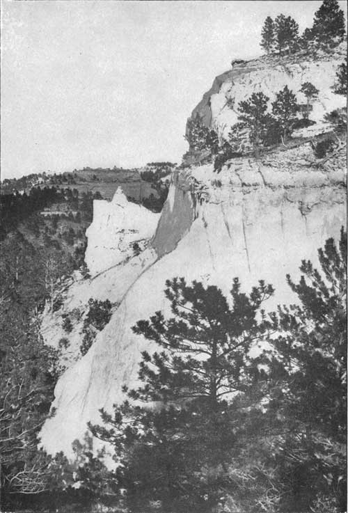
The Arikaree formation attains its greatest development in Pine Ridge, where it presents a thickness of about 500 feet. It constitutes a wide area of table-land extending from Pine Ridge to the northern margin of the valley of North Platte River. It occupies the ridge lying between the valleys of North Platte River and Pumpkinseed Creek, and to the southwest it is exposed in the slopes of the table-lands next south. The formation consists mainly of fine sand containing characteristic layers of hard, fine-grained, dark-gray concretions, often consisting of aggregations of long, irregular, cylindrical masses. These, for convenience, have been called "pipy concretions." They vary in thickness from a few inches to several feet, but from 10 to 15 inches is a fair average. Their trend is east-northeast and west-northwest with surprising regularity. The layers are often many square yards in area. A typical exposure of the concretions is shown in Pl. XVIII, B. The sands vary from loose to fairly compact, and some are argillaceous. The colors are uniformly light gray. Owing to the presence of the hard concretions, the formation generally gives rise to ridges of considerable prominence. The steep escarpment of Pine Ridge consists almost entirely of Arikaree cliffs, of which typical views are given in Pls. VIII, XVII, and XXI. The relations of the Arikaree formation to associated deposits are particularly well exposed in the slopes adjoining the Platte and Pumpkinseed valleys. The formation lies on the Gering beds at many points, but in some areas appears to rest immediately on the surface of the Brule clay. There is often no evidence of unconformity in either case. Usually there is an abrupt change in the character of the materials as the coarse beds of the Gering formation give place to fine massive Arikaree sands containing the pipy concretions. In some cases this concretionary development appears to have extended down into the Gering sediments, especially locally where these sediments are fine sands. This relation is illustrated in fig. 2, and possibly also in fig. 14, on page 35.

|
| FIG. 2.—Section 6 miles west of Gering, Nebr., showing relations of Arikaree and Brule formations. |
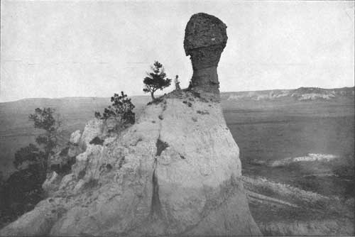
|
| PLATE XVI.—SMOKESTACK ROCK, LOOKING EAST, NEAR VIEW. Conglomerate in Arikaree formation. |
There is a possibility that the upper member of the Gering formation is a basal portion of the Arikaree formation, as suggested at some localities, which would often add difficulty to the identification of the Gering formation where it consisted of only one member. Along the north side of the Platte Valley, the south side of the Pumpkinseed Valley, and in portions of the ridge between these two valleys the Arikaree formation appears to lie directly on the Brule clay. In these instances there is often either only a faint suggestion of unconformity between the two formations when the exposures are carefully examined or simply a very rapid change from sandy, pinkish Brule clay, with some small siliceous concretions to fine gray sands with the typical character and pipy concretions of the Arikaree formation. Fig. 3 shows the usual relations presented in the exposures along the north side of the Platte Valley.

|
| FIG. 3.—Section of Arikaree and Brule formations on the north side of the valley of North Platte River. |
In Pl. XVII, B, is shown an exposure in which there is marked unconformity between Arikaree arid Brule deposits, and other exhibitions of similar relations are shown in sections A and C of Pl. XV, sections C and D of Pl. XXVII, and Pls. XXVI and XXVIII. The relations of the Arikaree formation to the Ogalalla formation are described on page 24. The two formations are sharply separated by an abrupt change in character of materials, and the basal Ogalalla beds are mainly conglomeratic. The thinning out of the Arikaree deposits to the southeast is clearly illustrated in many exposures south of Redington. All along the northern edge of the table-land in Banner County the formation has less thickness than it presents in the ridge north, where, in the vicinity of Wildcat Mountain, it is nearly 500 feet thick. Southwest of Harrisburg the amount is about 150 feet; south of Freeport it is 100 feet, as shown in Pl. XV, A; in Hackberry Canyon it is 40 feet; and at Langs Point Arikaree beds are absent, the Ogalalla conglomerate here lying directly on the Brule clay, as shown in section B of Pl. XV. Southeast of Langs Point there are a few thin outlying lenses of Arikaree beds, one of which is shown in section C of Pl. XV, but thence to the east it thins out and the typical relations presented are those shown in section D of Pl. XV. In the upper portion of the valley of Lawrence Fork there is an outlying area of the formation, only a few feet thick, between supposed Gering and Ogalalla formations, as shown in fig. 5 (p. 31).
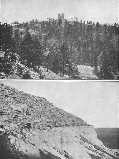
|
| PLATE XVII.—A (top), BUTTE OF ARIKAREE FORMATION, SOWBELLY CANYON, SIOUX COUNTY, NEBR. B (bottom), ARIKAREE FORMATION ON BRULE CLAY, SOUTHWEST PORTION OF SIOUX COUNTY, NEBR. |
Dæmonelix in various forms occurs extensively in this formation, and in Pine Ridge, in Sioux County, the large forms of the "Devil's corkscrew" are found in very great abundance in the upper beds of the formation. Prof. E. H. Barbour has described these forms in detail and given an account of their mode of occurrence.a The larger forms are most abundant in the upper portions of the depressions north of Harrison, but they were observed also as far east as Andrews, for some distance in the valley of Niobrara River above Royville, and as far west as Lush, in Wyoming. The smaller forms are very generally present throughout the region, and they also occur in the Ogalalla formation. In Pl. XIX is shown an exposure of typical Dæmonelix beds containing the large corkscrew forms. It is believed that no one observing these fossils in the field would have any doubt as to their vegetal nature.
aBull. Geol. Soc. America, vol. 8, 1897, pp. 305-314.
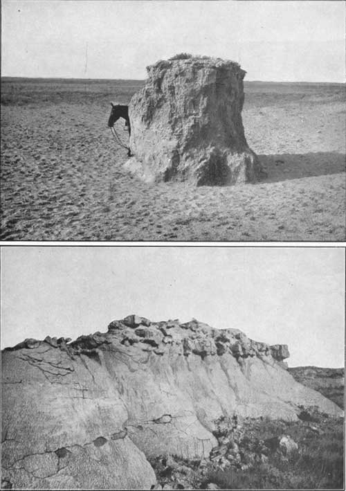
|
| PLATE XVIII.—A (top), BLOWOUT WITH CORE, ARIKAREE FORMATION, SIOUX COUNTY, NEBR. B (bottom), PIPY CONCRETIONS, ARIKAREE FORMATION, SCOTTS BLUFF COUNTY, NEBR. |
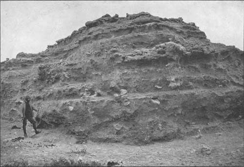
|
| PLATE XIX.—DÆMONELIX BEDS IN ARIKAREE FORMATION AT HEAD OF LITTLE MONROE CANYON, SIOUX COUNTY, NEBR. |
In a portion of its area the Arikaree formation has been observed to contain a series of old channels filled with coarse conglomerate. The occurrence of this conglomerate is apparently restricted to the ridge lying next south of North Platte River and to the vicinity of Spoon Butte, near the head of Sheep Creek, in Sioux County. The horizon is somewhat above the base of the formation, and the conglomerate is distinct from some local beds of coarse deposits occasionally noticed at or near the base of the formation.
Some of the relations of these conglomerate-filled channels are shown in section F of Pl. XXVIII, and in Pls. VI, XIV, and XVI, and fig. 5. Beginning at the east, the first outcrops observed were in Smokestack Rock, in Banner County. They were next seen at intervals westward along the south line of Scotts Bluff County, in buttes and high points, as far west as the meridian of Gering, and detached areas are exposed on the north side of the ridge southwest of Gering. The last outcrop occurs at a point 3 miles north-northwest of Dorrington, near the western end of the ridge, where it has the relations shown in fig. 4.

|
| FIG. 4.—Section 3 miles northwest of Dorrington, Nebr., showing the relations of conglomerate in Arikaree formation. |

|
| FIG. 5.—Sections 8 miles south-southeast of Gering, Nebr., showing relations of conglomerate in Arikaree formations. |
It is probable that the channel is continuous under the ridge between these points. Some features of the more prominent exposures are shown in Pls. XIV and XVI. The material is a conglomerate of pebbles and bowlders of gray sandstone, generally firmly cemented by siliceous matrix. The greatest thickness observed was 30 feet, in the high point 3 miles south of Larissa. Smokestack Rock exposes about 25 feet. At many localities it may be seen that the beds lie on typical Arikaree deposits, as shown in Pl. XLV, B, and they are overlain by typical beds of the same formation. This relation is shown in fig. 5 (p. 28) and fig. 12 (p. 34).
In the Spoon Butte and adjoining ridges the conglomerates are of somewhat different character, consisting in large part of crystalline rocks and apparently lying on a steeply sloping surface. The relations are shown in fig. 6.

|
| FIG. 6.—Cross section from the eastern end of Spoon Butte southward to Sturdivant ranch, looking east. |
In this vicinity it was not practicable to ascertain the relations to overlying beds.
The Arikaree deposits contain a large amount of volcanic ash, mainly as a constituent intermixed with the sand, but there are also several distinct beds of ash at one or two horizons, though only of local occurrence. The relations of these beds are indicated in section A of Pl. XXVIII and figs. 1, 7, 10, 12, and 18, and some further information regarding them will be found on page 42.
Molluscan fresh-water fossils of several species have been found in this formation, but they are not sufficiently distinctive to indicate its age precisely. One abundantly fossiliferons locality was discovered south of Gering, where the matrix was a thin bed of diatomaceous earth. Vertebrate remains were collected in small numbers.
GERING FORMATION.
Underlying the Arikaree formation, in a portion of the area, there is a series of coarse sands, often containing pebbles, which appears to be an entirely distinct formation. It is not separated by unconformity, but it has distinctive characters over an area of considerable extent. In its typical exposures it is separated from the Brule clays by a clearly marked unconformity, some of the features of which are shown in Pl. XXV. Its thickness varies from a thin wedge to over 200 feet. Its relations are extensively exhibited in the ridge lying next south of North Platte River, and it is thick and apparently continuous along the northern face of Pine Ridge. The southernmost exposures are some doubtful ones on Lawrence Fork, near its head. In Pls. XXVI, XXVII, and XXVIII, and figs. 7 to 17, the stratigraphic relations of this formation are illustrated. Its greatest development in the Platte Valley is south-southwest of Gering, where 200 feet are exposed, and about Chimney Rock, where a thickness of about 145 feet is attained. It is over 100 feet thick in Courthouse Rock and in the vicinity of Birdcage Gap and Redington Gap. To the west and south it thins out, and at some points along both sides of the ridge it is apparently absent, or possibly where it appears to be absent it is represented either by clayey members which are not distinguishable from the Brule clay or by fine sand with concretions resembling Ogalalla beds. Its absence is almost certain in the ridge about Wildcat Mountain. In Scotts Bluff the relations of the formation are very distinct and 60 feet are exposed. On the slopes north of Platte River the formation appears to be absent except in a small area near the southwest corner of Sioux County, where the features shown in fig. 7 indicate that the formation is probably present locally.

|
| FIG. 7.—Section of bluff in southwest corner of Sioux County, showing relations of supposed Gering formation. |
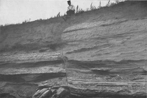
Along the north face of Pine Ridge the formation presents the features shown in figs. 19 and 20 (pp. 39 and 40) and Pl. XX.
|
| PLATE XX.—GERING FORMATION WITH FAULT, NEAR RUTLAND, DAWES COUNTY, NEBR. |
Some further facts and inferences as to its relations are shown in cross sections in Pl. XII. No definite evidence of the continuance of the formation could be found in the slopes south of Pumpkinseed Creek except in the valley of Lawrence Fork, in sec. 4, T. 16, R. 54, where there is an exhibition of the features shown in fig. 8.

|
| FIG. 8.—Details of unconformity between Brule clay and supposed Gering deposits in valley of Lawrence Fork, sec. 4, T. 16, R. 54. |
In the Lodgepole Valley the Arikaree formation appears to lie directly on the Brule clay, both the Gering and Ogalalla formations being absent.
|
| PLATE XXI.—CLIFFS OF ARIKAREE FORMATION, NORTH FACE OF PINE RIDGE, NEAR MONROE CANYON, SIOUX COUNTY, NEBR. (From photograph by E. H. Barbour, University of Nebraska.) |
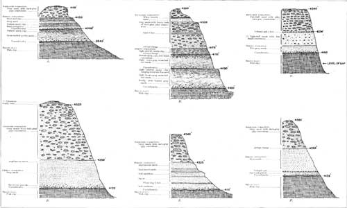
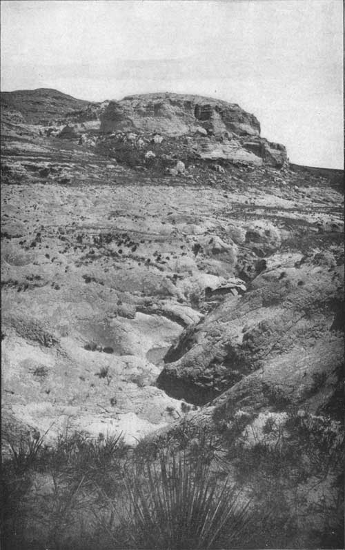
The Gering formation presents many local features of stratigraphy, particularly in the ridge between the valleys of Platte River and Pumpkinseed Creek. Beginning at Jail Rock there are instructive exposures at frequent intervals to the western end of the ridge. At Courthouse Rock there are presented the relations shown in section A of Pl. XXVI. At an altitude of 3,940 feet the distinctive Brule clay is unconformably overlain by the Gering formation, apparently comprising two members, separated by marked unconformity by erosion. In both members there are coarse beds below containing local conglomerate, merging upward into sand, and finally into sandy clay. The total thickness is 110 feet. The characteristic Arikaree formation capping Courthouse Rock begins abruptly, but with no sign of unconformity. Jail Rock, as shown in Pl. V, is capped by the Gering formation. The two members of this formation present about the same relations at Birdcage Gap as shown in section B of Pl. XXVI, but they have somewhat greater thickness. In the pinkish sandy clay, at an altitude of 4,080 feet there was found a portion of the skeleton of a new species of Dinictis.a A view of the relations in Birdcage Gap is given in Pl. XXII.
aRecently described by F. A. Lucas as Dinictis major: Am. Jour. Sci., 4th series, vol. 6, 1898, pp. 499-400.
|
| PLATE XXII.—ARIKAREE FORMATION, GERING FORMATION, AND BRULE CLAY, IN BIRDCAGE GAP, CHEYENNE COUNTY, NEBR. Looking northeast through the gap. |
At Redington Gap the upper member of the Gering formation is not distinguishable, and the total thickness is less. A local bed of volcanic ash 5 feet thick appears to mark the top of the formation. The principal features are shown in section C of Pl. XXVI. Three miles northwest of Redington Gap there was found the section shown in Pl. XXVI, D. The Gering formation here presents the usual basal beds of coarse material lying unconformably on the Brule clay. The change to the Arikaree formation above is abrupt, but not marked by unconformity.
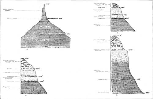
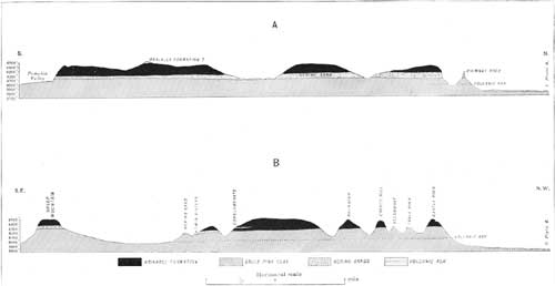
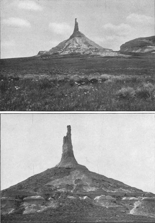
Approaching Chimney Rock there are presented the features shown in sections E and F of Pl. XXVI. The thickness of the Gering formation here averages about 125 feet, and there is much local variation in the stratigraphy. Coarse basal beds are often exposed lying unconformably on the Brule clay. A thin local bed of volcanic ash is conspicuous in some exposures. Chimney Rock consists of a spire of Gering formation rising from a conical hill of Brule clay. The material is a gray, thin-bedded, soft sandstone with slightly coarser materials at its base. The unconformable contact with the Brule clay is at an altitude of 4,100 feet, and there is here considerable carbonaceous material, strongly suggestive of an old soil. At an altitude of 4,135 feet there is a faint unconformity, just above which there are two thin beds containing volcanic ash. Two views of Chimney Rock are given in Pl. XXIV, and the relations of the formations are shown in section A of Pl. XXVII.
Southwest of Chimney Rock the Gering formation greatly decreases in thickness, hut it continues to present its characteristic features, as shown in sections B and C of Pl. XXVII. The two members are well characterized as far as the east side of Sheep Mountain. Along the south side of this butte the basal member of the Gering formation is, in places, not clearly separable.
At the curiously sculptured Twin Sisters, which are of Gering formation, the unconformity is finely exhibited, as shown in Pl. VII, A. The materials consist of coarse sands and soft sandstone, merging upward into a 6-foot bed of pinkish sandy clay, above which there is a moderately sharp break, followed by an upper member of gray sand which constitutes the heads and shoulders of the "Sisters." Some of the relations in this vicinity are shown in section B of Pl. XXIII, which also shows the apparent thinning out of the formation a short distance northward.
|
| PLATE XXIII.—CROSS SECTIONS, SHOWING RELATIONS OF FORMATIONS NEAR CHIMNEY ROCK AND HORSESHOE FLAT, NEBR. A, Near Chimney Rock; B, near Horseshoe Flat. (click on image for a PDF version) |
The Gering formation appears to be absent at the Smokestack and in Round Top, Coyote Hill, and Castle Rock. In Castle Rock, as shown in section D of Pl. XXVII, the Brule clays become sandy in their upper portion, but present no suggestion of stratigraphic break until the base of the well-characterized Arikaree deposits is reached, at an altitude of 4,340 feet, where there is an unconformity marked by a bed of white clay a foot thick on a carbonaceous surface, strongly suggestive of old soil. This soil and the relations of the formation indicate that there was here a land surface while the Gering formation was being deposited to the south.
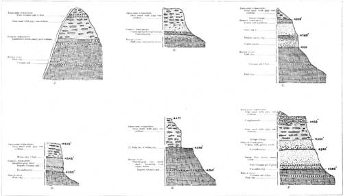
The Gering formation extends continuously for several miles west from the Twin Sisters. At a point 4 miles west-northwest it has the relations shown in section F of Pl. XXVIII, consisting of two members with an aggregate thickness of 120 feet. It contains the usual coarse beds at the base of each member, and in the base of the lower member there is a 2-1/2-foot bed of pure volcanic ash. In the next bluff, 1-1/2 miles northwest, there are exposed the features shown in section C of Pl. XXVIII.
In the next 1-1/2 miles the formation thins rapidly, as shown in section B of Pl. XXVIII, and it appears to thin out locally to the south and at intervals to the west.
In the high butte 2-1/2 miles west-southwest of Larissa, as shown in section A of Pl. XXVIII, the Gering formation is probably represented by a thin wedge of laminated sandstone, which is exposed on the south slope, but is absent to the north. In the buttes south of Gering the formation occurs in irregular masses, and for some distance is not over 50 feet in thickness. Its relations in this vicinity are shown in fig. 9, at B and C. At B in this section the Gering beds consist of sand and sandy clay, with streaks of conglomerate at their base. There is a very abrupt change to Arikaree beds at their summit. The details of stratigraphy at B are shown in fig. 10.

|
| FIG. 9.—Cross section of ridge 10 miles south of Gering, Nebr. looking west. |

|
| FIG. 10.—Section 7 miles due south of Gering, Nebr. |
At this exposure there is a bed of volcanic ash in the base of the Gering formation, with alternations of sands and sandy clays above to a sharp unconformity at 4,390 feet. Above this unconformity are sands, pebbly at base, which appear to merge up into the Arikaree beds. They may, however, constitute the upper member of the Gering formation.
|
| PLATE XXIV.—A (top), B (bottom), CHIMNEY ROCK, CHEYENNE COUNTY, NEBR. A, From the west, showing volcanic-ash bed; B, from the east, Gering sandstone on Brule clay (the horse is on a bed of volcanic ash). |
|
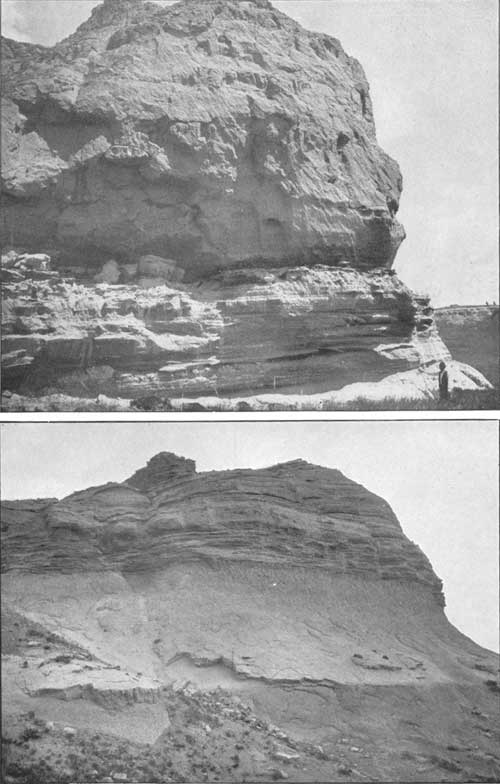
| PLATE XXV.—A (top), B (bottom), GERING FORMATION LYING UNCONFORMABLY ON BRULE CLAY, CHEYENNE COUNTY, NEBR. A, With conglomeratic beds, 4 miles northwest of Redington (the man's hand is at the contact), B, 2 miles southwest of Chimney Rock. |
In the very prominent point in the northwest corner of T. 20, R. 55, 6 miles south-southwest of Gering, the formation attains its maximum development for this district, having a thickness of 200 feet and the composition shown in fig. 11.

|
| FIG. 11.—Section of Gering and associated formations 6 miles south-southwest of Gering, Nebr. |
A mile south of this exposure the Gering beds have the character and relations shown in fig. 12, which illustrates the thinning to the south.

|
| FIG. 12.—Section of Gering and associated formations 7 miles south-southwest of Gering, Nebr. |
The unconformity at 4,480 feet may be either in the Gering formation, separating it into two members, or at the base of the Arikaree formation, here including coarse beds and a thin layer of nearly pure volcanic ash. West of this vicinity the formation again thins rapidly, and on the north side of the upper part of Cedar Canyon it has the relations shown in fig. 13.

|
| FIG. 13.—Section of Gering and associated formations in Cedar Canyon, 8 miles southwest of Gering, Nebr. |
One mile northeast of this exposure, in the high point at the mouth of Cedar Canyon, the formation is only doubtfully recognized, with the relations shown in fig. 14. In other places to the west and north for some distance the formation is either absent or very thin and not well characterized.

|
| FIG. 14.—Section of Gering and associated formations at the mouth of Cedar Canyon, 7 miles southwest of Gering, Nebr. |
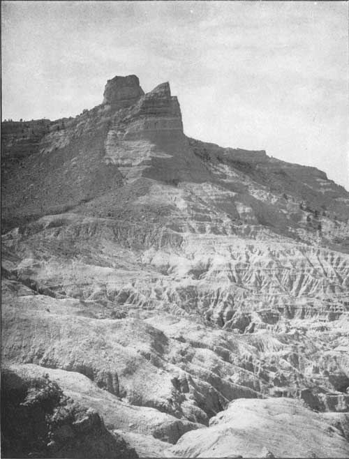
In the Scotts Bluff ridge west of Gering the Gering formation has a thickness of 60 feet. It is finely exposed in the butte of which Scotts Bluff is the north face, where its relations are as shown in fig. 18. Some of its features may also be seen in Pl. XXIX. Dome Rock exhibits 50 feet of the Gering formation, capped by a small mass of Arikaree formation. In the vicinity of Signal Butte the Gering formation appears to be represented by 60 feet of laminated dark-gray sands or soft sandstone lying unconformably on the Brule clay, the unconformity being strongly marked. At the top of the butte there is a cap of thin, hard, white calcareous deposit, which extends widely in the vicinity. The relations are shown in fig. 15.

|
| FIG. 15. —Section at Signal Butte, Scotts Bluff County, Nebr. |
The Gering formation is developed in places north of Dorrington with the relations shown in fig. 16. The thickness is 50 feet, and the coarse basal beds lying unconformably on the Brule clay are finely exposed at several points. The formation also here contains a thin bed of volcanic ash near the top.

|
| FIG 16.—Section of Gering and associated formations 2 miles northeast of Dorrington, Nebr. |
Along the south side of the ridge from Dorrington to Ashford the formation is either absent or not characteristic. Near Funnel Rock the Arikaree beds lie unconformably on the Brule clay, as shown in fig. 17. In the region north-northeast of Ashford the Gering formation is very distinct again for a few miles, especially high up in the canyons which are cut into the ridge. In two of these canyons the outcrop is marked by large springs. The relations in this vicinity are represented at D, E, and F in fig. 9 (p. 32). At D, high up a canyon, there is a fine exposure of 50 feet of coarse Gering beds lying unconformably on Brule clay and fairly sharply separated from Arikaree beds. At E, farther down the canyon, similar relations are exhibited. At F, on the point at the mouth of the canyon, there is no trace of the coarse beds; the fine sand, similar to that of the Arikaree deposits, but with smaller and more widely scattered concretions, lying directly on the Brule clay, with faint unconformity apparent. Farther east, at Castle Rock, in Banner County, and in the prominent point 1-1/2 miles west of this rock, the identity of the formation is not satisfactorily established. The relations at these localities are shown in sections D and E of Pl. XXVIII. In the bluffs on the south side of the ridge, northeast of Redington, the Gering formation is again recognized. Its unconformity to the Brule clay is often finely exposed in this vicinity, as shown in Pl. XXV, B.

|
| FIG. 17.—Section in vicinity of Funnel Rock, 1 mile north of Ashford, Nebr. |

|
| FIG. 18.—Section of north face of Scotts Bluff. |
BRULE CLAY.
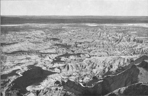
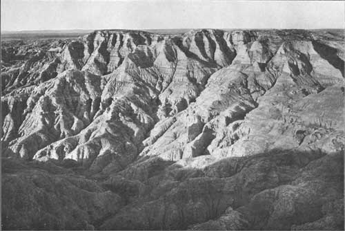
This thick mass of sediment which underlies the greater part of the region consists mainly of massive clay or a mixture of fine sand and clay, of pale flesh color, containing numerous fossil beds characteristic of the Oreodon series of the White River group. It is widely exposed in the valleys of North Platte River and Pumpkinseed Creek, extends along the lower portion of the northern slope of Pine Ridge, and is bared in the narrow depression of Lodgepole Creek and Sidney Draw. In the valley of the North Platte it is often widely overlain by alluvial deposits, and this also is the case to a less degree in the smaller valleys. Along the foot of Pine Ridge the formation is largely covered by wash and talus, and by a small amount of alluvium along White River and its tributaries. The formation underlies all the high table-lands, where, as shown in the sections of Pl. XII, it is thickly covered by the later Tertiary deposits. North of Pine Ridge it has been deeply eroded, and beyond a narrow zone of outcrops of the underlying Chadron beds the Pierre clay succeeds as the surface formation. There are extensive exposures of the Brule clay in the northern face of Scotts Bluff, where, from the base of the overlying Gering beds to the river, there is a vertical interval of 500 feet of continuous outcrop, and the formation has a small additional thickness below the level of the river. (See Pls. XXX and XXXI.) Along the northern front of Pine Ridge the formation averages 600 feet in thickness, but beginning near Crawford it gradually thins to the east to about 350 feet in the vicinity of Chadron. In Round Top, just west of Adelia, there are 655 feet of Brule beds.
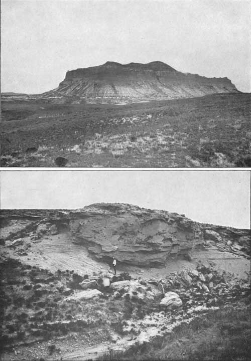
In the region southeast of Gering the Brule formation contains a bed of coarse material which appears to extend several miles. It consists of coarse, cross-bedded sand and conglomerate lying about 120 feet below the top of the formation. The thickness varies from 10 to 80 feet, the thickest portion appearing in canyons and buttes 5 to 6 miles south of Gering. The relations in this vicinity are illustrated in fig. 9. (p. 32), and one of the finest exposures is shown in Pl. XXXII, B. There are other exposures north of Larissa and northeast of Chimney and Castle rocks, as shown in sections A and D in Pl. XXVII. In the area near Larissa and south of Gering there is near its base a thin bed of very compact limestone, which again outcrops north of Sunflower.
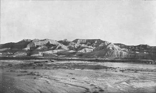
In the badlands about Adelia station on the Burlington and Missouri River Railroad there are extensive exposures of the Brule and associated formations. (See Pls. XXXIII and XXXIV and fig. 19.)

|
| FIG. 19.—Section from Round Top to Adelia station, Sioux County, Nebr. |
This section closely resembles the typical section in the Big Bad Lands in South Dakota, but appears to include some higher beds. The alternate greenish and pinkish clays with brown nodular layers lying on the Chadron sands are similar to the Oreodon series and yield many of the same mammalian remains. The sandstone next above probably represents the Metamynodon series, and in it was found a fragment of a tooth, probably of Metamynodon. The overlying clays can be less definitely correlated, especially those toward the top, which I believe are higher than the highest beds represented in the Big Bad Lands. They contain two beds of volcanic ash, the upper one 12 feet thick, of nearly pure material, in flat, glassy scales, not so vesicular as usual. Along the eastern extension of Pine Ridge the intermediate beds, those extending from 4,000 to 3,725 feet in the Round Top section, soon thin out, and the Chadron formation is overlain by the flesh-colored clay, with its volcanic ash layer near the top. A section at Chadron is given in fig. 20.

|
| FIG. 20.—Section at Chadron Nebr. |
|
| PLATE XXIX.—NORTH FACE OF SCOTTS BLUFF. Brule clay overlain by Gering and Arikaree formations. |
CHADRON FORMATION.
This basal formation of the Tertiary series outcrops in a narrow zone along the lower slopes north of Pine Ridge, just outside the margin of the overlying Brule clays. There is also a small area of outcrop in the valley of North Platte River in the vicinity of Caldwell and Mitchell. The deposits have heretofore been known as the "Titanotherium beds," from the frequent occurrence of remains of several species of a large mammal which has been named Titanotherium. As the large bones and peculiar teeth of this animal are very distinctive features, an illustration of a skeleton is reproduced in Pl. XXXV. The predominant material of the formation is sandy clay of light greenish-gray color, usually with coarser beds at the bottom, including deposits of gravels often several feet thick. The beds above these gravels are often of bright dark-red color, notably in the region about Adelia. The thickness of the formation varies from 30 to 60 feet in the outcrops along the foot of Pine Ridge. It thickens considerably in the vicinity of Adelia, where there are included some masses of dark-gray and buff sandstone of coarse texture. At many points around its outer margin the Chadron sands may be seen lying on the irregular, black, or generally rusty surface of the Pierre shale.
|
| PLATE XXX.—BADLANDS AT FOOT OF SCOTTS BLUFF, GENERAL VIEW. |
|
| PLATE XXXI.—BADLANDS AT FOOT OF SCOTTS BLUFF, NEAR VIEW. |
LARAMIE FORMATION.
The Laramie formation is exposed in an area of considerable extent in Goshen Hole, which extends for a short distance eastward into Nebraska on the north side of Horse Creek west of Caldwell and on a branch of that creek 5 miles southwest of Caldwell. The rock is a soft greenish-buff to brownish sandstone. Its surface is irregular; to the north it is overlain by Chadron beds and to the south it rises into the base of the Brule clays. Doubtless it extends for some distance east, but its eastern margin was not ascertained.
PIERRE CLAY.
The entire region to which this report relates is underlain by the Pierre clay, a thick mass of dark-colored clays or shales constituting the upper member of the Cretaceous formations in some portions of the Plains. Possibly under the southwest corner of Nebraska the Tertiary formations are underlain by the edge of the Laramie formation—a series of sandstones higher in the Cretaceous—but of this there is at present no evidence. The Pierre shale outcrops in the northern portion of Sioux and Dawes counties, as shown in Pl. XI. The surface of the formation rises somewhat with the general upward slope of its beds toward the Black Hills uplift, and it is exposed by the erosion which has removed the Tertiary formations over the lowlands extending from the valleys of White River and Hat Creek to the foot of the Black Hills. The dark shale gives rise to a rolling region of scant vegetation and poor water supply. Exposures are frequent, and the dark-yellow or rusty surfaces due to the oxidation of the iron pyrites in the shale are characteristic features of the area.
Distinctive fossils of numerous marine mulluscan species are abundant in the Pierre clay. The fossils are often preserved in concretions of gray siliceous matter of lenticular form, which abound in the upper portion of the formation. The precise thickness of the Pierre shales is not known, but it probably exceeds 1,200 feet.
NIOBRARA LIMESTONE.
The Pierre shale is underlain by the Niobrara limestone, but this formation does not reach the surface in the portion of Nebraska west of the one hundred and third meridian. As, however, it would be reached by deep borings for artesian water, some of its characteristics should be pointed out. Its thickness is about 50 feet. It consists mainly of massive dark-gray chalk or soft limestone, which weathers to a buff or light-cream color when exposed to the atmosphere. The formation can be readily recognized by the very distinctive fossil Ostrea congesta, which is nearly always present in abundance in thin, hard layers. In order to aid the well driller in identifying this formation in borings, an illustration of this fossil is introduced in Pl. XXXVI.
BENTON FORMATION.
Underlying the Niobrara limestone and abruptly separated from it are the Benton shales, which have a thickness of 1,500 feet. They contain thin layers of sandstone and limestone; one of the latter, about 900 feet above the Dakota sandstone, is filled with the Inoceramus shown in Pl. XXXVI. The formation lies far below the surface along the South Dakota line, but outcrops extensively in the vicinity of Edgemont, having the relations shown in fig. 21.

|
| FIG. 21.—Section from Black Hills to Pine Ridge. |
DAKOTA SANDSTONE.
This is, the water-bearing sandstone of South Dakota and northeastern Nebraska, and it underlies all the region to which this report relates. It is a gray or brownish sand rock, occurring in thick beds, with intercalated lenses of shale or clay and occasionally thin seams of coal. Its relations in the northern part of the area are shown in fig. 21 and Pl. X. Its lower beds are of Lower Cretaceous age.
|
| PLATE XXXII.—A (top), CASTLE ROCK, SCOTTS BLUFF COUNTY, NEBR., FROM THE EAST, SHOWING BED OF VOLCANIC ASH NEAR THE FOOT OF THE SLOPE. B (bottom), LENS OF COARSE MATERIAL IN BRULE FORMATION, 4 MILES SOUTH OF GERING, NEBR. |
|
| PLATE XXXIII.—BADLANDS OF BRULE FORMATION, WEST OF ADELIA, SIOUX COUNTY, NEBR., LOOKING NORTHWEST. (From photograph by E. H. Barbour, University of Nebraska.) |
VOLCANIC ASH.
In studying the geology of this region it was found that several formations contained extensive deposits of volcanic ash. Some of this material was found in the Chadron formation; two very widespread beds occur in the Brule clay; lenses of the ash are often included in the Gering formation; and there is a general admixture of ash as well as a number of thick beds of it in the Arikaree formation. So far as observed it is rare in the Ogalalla formation. In the central and eastern portion of the State it occurs mainly in the lower portion of the loess.
The ash deposits are usually more or less mixed with clay or sand, but there are many beds in which the deposits are thick and pure. They promise to have considerable commercial value, mainly for polishing powder.
The most persistent layer is in the Brule clay, at an average distance of about 70 feet below its top, in the ridge next south of North Platte River. This bed is shown in Pl. XXIV and Pl. XXXII, A. A lower bed, usually much less pure, occurs from 80 to 100 feet below the upper one. On the north side of Pine Ridge these two horizons are recognized in some of the higher beds in Sowbelly Canyon and at Round Top and near Chadron, as shown in figs. 19 and 20. The volcanic ash occurring in the Gering formation is usually restricted in extent and variable in relations. It is, however, often exceptionally pure.
The Arikaree formation contains a sprinkling of ash almost throughout its extent. In some of the bluffs southwest of Gering a thickness of 100 feet of sandy clays of this formation was observed, which contains a fairly large proportion of ash. In the high isolated butte 3 miles west by south from Larissa there is a 15-foot bed of nearly pure ash, with pipy concretions scattered through it, in the midst of the Arikaree formation. In Wildcat Mountain beds of ash were found at intervals nearly to the cap of Ogalalla formation. The formation contains a large admixture of ash in the vicinity of Fort Robinson and again at Round Top, near Adelia, as shown in fig. 19 (p. 39).
The ash in these formations was probably derived from volcanoes in the Rocky Mountain region, for there is no evidence of Tertiary volcanoes in the vicinity. The ash was undoubtedly borne on the winds and deposited in the waters which laid down the several Tertiary formations. When the ash came in large volume, or there was very little other sediment, pure deposits resulted; but ordinarily there was considerable admixture of the fine sand and clay.
| <<< Previous | <<< Contents >>> | Next >>> |
pp/17/sec2.htm
Last Updated: 24-Aug-2009
