|
Geological Survey Professional Paper 294—K
The Rocks and Fossils of Glacier National Park: The Story of Their Origin and History |
THE GLACIERS
The more striking features of the scenery of Glacier National Park result from glacial sculpture, but glacial sculpture there and in the adjacent Waterton Lakes Park could not have been so spectacular if the geologic history had been different. The effects of glaciation are outlined below, but the processes of glaciation which are described in other publications, are not given detailed treatment.
Glaciers formerly existed in all the mountains of the general region, but glacial sculpturing on a scale comparable with that in the two parks is absent. One reason is that the large and massive Lewis and Livingstone Ranges rise farther above the lowlands at their bases than the nearby ranges. Another is that the thick-bedded, relatively flat-lying but much-jointed rocks of the Belt series are ideally suited to yield cliffs, aretes and other awe-inspiring forms through the agency of glacial sculpture. The forms of the Lewis overthrust itself and of the great slab of rock moved forward by that thrust had much to do with localizing the cliffs and aretes within the area now covered by the two national parks. Further, the eastern front of the mountains of Glacier National Park would not be nearly so impressively precipitous today if the geologic structure had not been such as to facilitate rapid retreat of that front by undermining or sapping once erosion was in a position to attack. Details of the structure of the slab above the thrust zone are reflected in the modern topography. For example, the stream pattern corresponds largely to zones of structural weakness in the rocks. Many of the higher, more rugged mountains are carved from crumpled and upheaved rocks. The largest and broadest downwarp in the rocks is reflected by relatively low and flat-topped mountains, such as Flattop Mountain in the north-central part of the park. The contrasts that have resulted from features of this kind add to the interest of the scenery.
Not long after the close of the Tertiary period the climate of the Northern Hemisphere changed so that hinge glaciers formed on the northerly parts of the land areas and smaller glaciers formed in mountain masses farther south. Vast sheets of ice—glaciers of continental proportions—originated in Canada and moved outward in all directions from the centers of ice accumulation. In the Mississippi Valley, and, to a less extent, farther east, the continental glaciers advanced hundreds of miles into the United States. In Montana they approached but never quite reached Glacier National Park. The edge of the continental glaciers barely entered the northeast corner of the region shown in plate 51. Smaller glaciers formed in the mountains, originating near range crests and flowing down valleys. Glaciers of this sort are termed mountain or alpine glaciers or, emphasizing the features that restrict them, they may be called valley glaciers. All such terms contrast the glaciers within mountains with the continental glaciers that spread with relatively little regard for local topographic forms.
In the Glacier National Park region the Blackfoot surface had been cut by reinvigorated streams before mountain glaciation began. When conditions made it possible, glacial ice gathered at the heads of the streams and started to flow down the valleys. Thus, about a million years ago, began the glaciation of the ice age (the Pleistocene epoch of the geologic time scale). The climatic factors responsible for the extensive glaciation probably were complicated, and as yet they are not well understood, but the fact that such glaciation did take place was long ago established. A wealth of detailed information about the vicissitudes of the ice age and the changes its glaciers wrought has been gathered as a result of studies made in many parts of the world, including the region of Glacier National Park.
As soon as mountain glaciers started they began to carve the rocks on which they lay. In upland valleys the ice plucked out joint blocks and started to produce the cliffs and supersharp ridge crests for which Glacier National Park is famous. The rocks attacked by the ice were broken down into rubble which, in turn, was embedded in the moving ice and served to scour off the surfaces over which the glaciers advanced. Many of the lakes throughout the park were formed by rubble laden ice that bit into the rock, forming hollows that were later to be filled by water. Some of the lakes have been increased in size and some might have been created by dams of loose material thrown across valleys by the glaciers or by tributary streams after the glaciers had retreated.
Glacial erosion was accompanied by glacial deposition. In many places more rubble was formed than could be ground up into silt or carried away either by the glaciers themselves or by the streams of meltwater that issued from them. Piles of debris accumulated along the sides and at the ends of the glaciers. Within the mountains, debris masses (moraines) left by the glaciers of the ice age partially have since been swept away or modified beyond ready recognition. Where large mountain glaciers reached and spread on the plains or in broad valleys cut in the plains, the ground over wide areas was mantled by glacial debris, in places to depths of scores or even hundreds of feet. As a result, even now, bedrock in most areas east of the mountains can be seen only in the sides of valleys trenched through the glacial mantle by later streams.
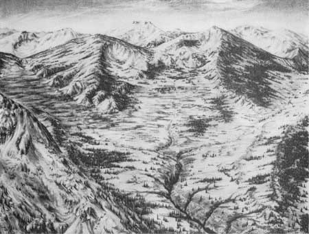
Glaciation was by no means continuous. The glaciers grew and retreated in sensitive response to fluctuations in climate. Within the ice age proper there were two sharply separated glacial episodes, each of which might have had at least two subdivisions. During the first of the two major episodes the ice occupied and enlarged former stream valleys incised in the Blackfoot surface. The glaciers covered much of the mountainous tract and extended to the plains east of the mountains. An interruption might have occurred with in this glacial episode at least long enough for the ice to have disappeared temporarily from the plains. At the close of the first major episode the ice might have melted almost entirely. Stream erosion appears to have been extremely active at this time, so that the valleys were deepened greatly and much of the glacial detritus in them was swept out. The great valleys of the region were cut almost to their present depths during this interglacial interval. Apparently some were deepened as much as 3,000 feet. Figure 143 is a view of a portion of the area as it might have appeared while the deepening by stream erosion was in progress.
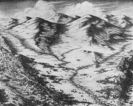
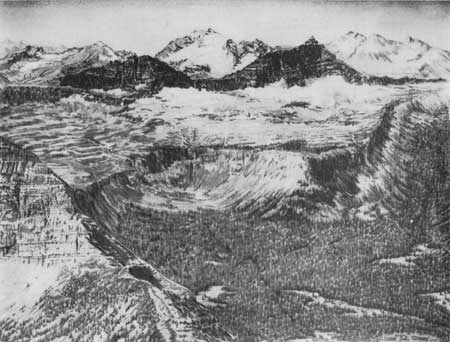
Views showing stages in the development of the present topography in Glacier National Park are given in figures 142, 143, and 144.

|
| FIGURE 142.—A stage in the development of the present topography in Glacier National Park, based on an inclined aerial photograph of the head of Red Eagle Creek in the Lewis Range: Topography after the Blackfoot surface had formed. |

|
| FIGURE 143.—A stage in the development of the present topography in Glacier National Park, based on an inclined aerial photograph of the head of Red Eagle Creek in the Lewis Range: Topography at about the middle of Pleistocene time, early in the stage of accelerated erosion that preceded the main Wisconsin glacial advance. |

|
| FIGURE 144.—A stage in the development of the present topography in Glacier National Park, based on an inclined aerial photograph of the head of Red Eagle Creek in the Lewis Range: Topography at the present time. |
When the glaciers returned after the interglacial interval, they moved down the greatly deepened valleys and nearly filled them with ice. All the mountains except the higher peaks and ridge crests were buried under the ice streams. Probably few peaks rose more than 1,000 feet above the ice. Some of the larger glaciers not only reached the plains to the east but pushed many miles across them, depositing detritus. A few trunk glaciers are thought to have reached to, or close to, the border of the continental glacier that entered the northeast corner of the region, as shown in plate 51.
West of the Continental Divide also, many large glaciers filled the mountain valleys. The largest passed westward through Bad Rock Canyon and possibly other openings in the mountains beyond the park limits into Flathead Valley, where they joined ice moving south ward from Canada. The confluent ice lobe pushed southward to the site of the town of Polson, where it deposited the morainal dam which impounds Flathead Lake. At an earlier stage, a similar ice lobe reached 18 miles still farther south, leaving a moraine near Charlo, Mont.
| <<< Previous | <<< Contents >>> | Next >>> |
pp/294-K/sec6.htm
Last Updated: 08-Jul-2008