
|
Geological Survey Professional Paper 3
The Geology and Petrography of Crater Lake National Park |
THE GEOLOGY OF CRATER LAKE NATIONAL PARK
By JOSEPH SILAS DILLER.
MOUNT MAZAMA.
(continued)
LAVAS OF MOUNT MAZAMA.a
There are three types of lavas in Mount Mazama—andesites, dacites, and basalts—and their areal distribution is represented on the accompanying map (Pl. VI). The immediate rim of the lake is made up wholly of andesites and dacites, chiefly the former; the basalts are limited to the outer slope. They came from the smaller vents around the base of the larger cone.
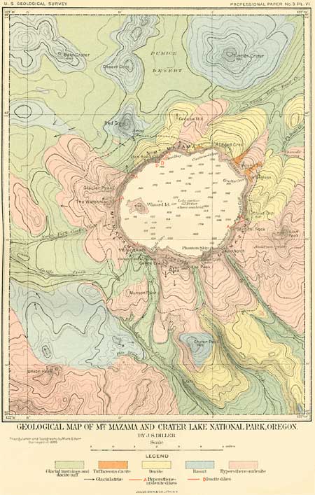
Plate VI—GEOLOGICAL MAP OF MT. MAZAMA AND CRATER LAKE NATIONAL
PARK, OREGON.
(click on image for an enlargement in a new window)
The theory of magmatic differentiation, so ably advocated by Professor Iddings and others in this country to explain differences in lavas erupted from the same volcanic center accords well with the course of events in Mount Mazama. Its eruptions began with and long continued to be composed of lava having intermediate composition. This lava was followed first by less siliceous lava, the basalt from a number of small vents on the flanks of the great volcano, and finally by the dacites, which closed the petrographic cycle. It is possible that the basalts and dacites may have been in part contemporaneous, but the last eruption from the great mountain was of dacite. Then came the great engulfment, and a new petrographic cycle began with the andesite of Wizard Island.
aThe rock specimens connected in the vicinity of Crater Lake have been studied by Prof. H. B. Patton, and are described in detail in the second part of this paper. The numbers used in both papers refer to the same collection.
ANDESITES.
Andesites constitute by far the greater portion of the lavas of Mount Mazama. A rough estimate makes their volume at least ten times the combined volume of the dacites and basalts. They form almost the whole of the inner slope of the rim, where the overlapping sheets of successive flows appear in section in their order of eruption, from the earliest to the latest. Flows lying at a depth of nearly 2,000 feet beneath the mountain slope are seen, but a much larger amount of flows still deeper is unexposed. Were it possible to remove the water of the lake, the thickness of the exposed lava would be nearly doubled, and there is no evidence to show that its character is very different from that which now outcrops by the water's edge around the lake. However, at still greater depths there probably occur Tertiary and Cretaceous sediments resting on older rocks similar to those of the Klamath Mountains. Hornblende- and mica-andesites, which are commonly associated with the hypersthene-andesites of the great volcanic centers of the Cascade Range as, for example, Lassen Peak, Mount Shasta, and Mount Hood—have not been found in Mount Mazama. Traces of hornblende were observed in only two of the hypersthene-andesites collected; one of these is a massive sheet nearly 100 feet thick along the trail near the point where it begins the descent to the lake (44),a and the other is a gray lava (45) on the slope of Castle Crest.
aThe rock collection to which the numbers refer is in the National Museum, Washington, D.C.
The oldest flows exposed on the southwest side of the lake are represented by specimens Nos. 24, 61, 11, and 163. They are overlain by many streams which successively issued and spread from the summit or upper slopes of Mount Mazama. The flows vary greatly in size and number in different portions of the rim. In places as many as 30 superimposed layers, mixed with many beds of fragmental material, make up the wall of the rim. The largest number of flows exposed in one section occurs about Sun Creek Notch. Many flows are 30 to 40 feet in thickness. Under Castle Crest nearly a score appear in this steep slope, and they range from 30 to 80 feet in thickness. Between many of them are layers of volcanic conglomerate, which are usually thin, and, being softer, less prominent. In the western rim flows are not so numerous, and conglomerate was estimated to form about one-fourth as large a mass as the solid lava. More fragmental material appears to have accompanied the earlier than the later flows, and on the whole there is a larger proportion in the rim at the head of Anna Creek than elsewhere. In the East Palisade (Pl. VII, B) the thickest flow of andesite is well exposed. It is cut by many joints, reaches more than halfway from the water to the crest of the rim, and has a thickness of nearly 500 feet.
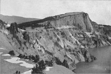
Plate VII—A. INNER SLOPE OF GLACIER PEAK.
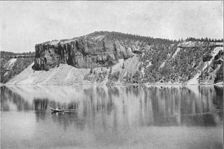
Plate VII—B. EAST PALISADE.
The thickness of any flow upon the mountain slope depended chiefly upon the amount of lava, its liquidity, and the inclination of the surface over which it flowed. Many of the sheets are uniformly thin. They follow the outer slope for considerable distance, and indicate a moderate supply of lava that flowed easily. Other flows, as that of the Palisades, filled valleys in the outer slope of Mount Mazama and varied greatly and abruptly in thickness, becoming very thin on their edges. The thickest of all the flows, however, is the great dacite flow of Llao Rock, which is over 1,200 feet thick over the middle of an old valley. The material was evidently very much less fluent than the andesites, for the flow, although thick, is short and narrow.
In distribution the andesites on the outer slope of the rim are divided into ten areas, and each may be designated by some contained feature, as The Watchman, Castle Creek, Munson Point, Union Peak, Eagle Crags, Dutton Cliff, Sentinel Rock, Round Top, Bear Creek, and Steel Bay. All these areas are practically joined by a complete ring of andesite exposed upon the inner slope of the rim of the lake. In addition to these areas around the rim is Wizard Island, which is also composed of andesite.
WATCHMAN ANDESITE AREA.
The area of which The Watchman is part contains a number of separate flows, but upon the map they are not distinguished. They are particularly well exposed by numerous cliffs, but in much of the area they are covered by glacial material. Although the flows are much alike when compared with one another, there is considerable variation within each flow. The holocrystalline gray forms, like No. 60, pass into the type like No. 6—dark, porous, soft, and crumbly, but rich in amorphous matter—and No. 26, which is decidedly vitreous. The composite character of the flows may be best seen upon the inner slope, where their sections are exposed. The andesites are generally gray, and may be reddish. They are seldom as vitreous as No. 26. No. 60 has a decidedly platy structure, which is locally well marked, although absent at other points. The plates are usually about one-half inch to an inch in thickness, and strike N. 70° E. nearly parallel to the spur, with a dip of 25° NW. The thickness of the plates at each outcrop is rather uniform, but it varies between the outcrops.
At The Watchman and Glacier Peak the layers of lava have a decided upward curve when viewed from the lake, and suggest that the volcanic vent from which the lavas of that portion of the rim issued was not central over the lake, but much closer to the western border. This view is fully borne out by the character of the igneous material in Glacier Peak. It is composed in small part of darker slaggy andesites and much red, yellow, or whitish fragmental material which is highly colored, as if by the escape of hot volcanic gases near the vent. From the lake these colored patches are brilliant in the morning light. On the inner slope of Glacier Peak (Pl. VII, A) are numerous columns, one of which is over 100 feet high. To call this Glacier Peak is a misnomer, for the glaciation here is much less distinct than on the hills farther south along the rim.
CASTLE CREEK ANDESITE AREA.
On the western border of the rim north of Castle Creek is a hill of andesite much like that a short distance to the east, from which it is separated by a belt of glacial drift.
MUNSON POINT ANDESITE AREA.
For 2 miles from the crest of the rim the divide between Castle and Anna creeks is covered largely by morainal material, but andesites finally crop out in occasional cliffs and give evidence of the character of the rock beneath the surface deposits in the Munson Point area. A somewhat dacitic specimen (79) from one of the rounded ledges of this area was found by Dr. Patton to contain tridymite. To the south and southwest, beyond the main road, this andesite is covered by a large mass of basalt.
UNION PEAK ANDESITE AREA.
Toward the southern border of the area mapped, near Pole Bridge Creek, is a mass of andesite, forming a bold, rocky point, which has been strongly glaciated on the side toward Crater Lake. The two types of andesite (41 and 100) found here do not look entirely alike, yet the rocks appear to be the same. The first is andesitic in appearance and the second somewhat dacitic. This is part of the large area which is outlined as including Union Peak, but is recognized as containing much basalt. Although the summit of Union Peak is hypersthene-andesite, the middle and lower slopes upon the eastern side are composed of basalt occasionally rich in olivine. There was no opportunity to map the southern and western borders of the park in as great detail as the other portions.
EAGLE CRAGS ANDESITE AREA.
The large area of andesite forming the broad divide between Anna and Sun creeks is made up of many prominent sheets. This is best seen from Dutton Cliff, where the edge of the platform appears under Vidae Peak, the highest point in the rim of the lake. Although the structure is partially obscured by steep talus slopes, enough is visible to show that the rim is made up of successive sheets of lava, which dip away from the lake approximately parallel to the present surface. On the upper surface of this platform exposures are few, excepting where the surface layer of sand and pumice is removed.
In strong contrast to the eastern edge is the opposite border of this platform in Castle Crest, which is rugged, and so sharp as to be impassable. At the foot of a precipitous wall a thousand feet high, on the north side of this serrated crest, lies Crater Lake. This is the only portion of the crest that is practically impassable. In the summit of Castle Crest the gray andesite is like that which is most common about the rim, but was found by Dr. Patton to contain a small amount of hornblende, thereby affording an approach toward hornblende-andesite, which has not yet been found about Crater Lake. On the ragged edge of Castle Crest, toward Eagle Crags, are great masses of volcanic conglomerate, such as are rarely exposed on the outer slope of the rim, but are common on the inner slope. They frequently alternate with solid sheets of andesite, and sometimes attain large dimensions, especially in the southwestern portion of the rim. They are generally composed of fragments of andesite, rich in amorphous matter and often dark or red in color. On the divide south of Dyer Rock there is much morainal matter and pumice, so that the solid lavas rarely outcrop, but where they do they are well glaciated.
Near the southern margin of the area mapped is Crater Peak, a hill of basalt resting on a platform partly of andesite and partly of dacite. The relative age of these rocks is clearly shown, and is further demonstrated by the fact that fragments of the underlying andesite were thrown out during the activity of the basaltic crater.
Great cliffs of andesite border Sun Creek Canyon in places, and the rock is well exposed also at the falls where Sun Creek, at an altitude of about 6,500 feet, leaves the broad U-shaped valley and plunges 400 feet over a series of cascades into a sharper canyon cut in dacite. This line of cliffs across the course of Sun Creek connects the andesites of the two divides east and west of that stream.
DUTTON CLIFF ANDESITE AREA.
In the broad divide between Sand and Sun creeks andesite plays a smaller part and shows but little variation. Near the middle of the divide, at an altitude of about 7,000 feet, there is an andesite (76) full of secretions (98). The andesite is quite normal, but the inclusions are basaltic. The same material with secretions occurs in the form of large bowlders near by, and a short distance to the west, in one of the head gulches of the West Fork of Sand Creek, it is overlain by a decidedly platy andesite (27). Similar andesite (50) full of secretions was seen near the edge of the water under Sun Creek Notch. The andesitic lavas of the south rim are much alike everywhere, with the exceptions noted above, and are represented by Nos. 50 and 46, the latter from Dutton Cliff, where it is capped by 10 feet of pumice.
Sand Creek, like its neighbor, is bordered by great cliffs, especially on the west. Ascending this creek one-half mile south of the lake rim, I collected a platy andesite (36) at the bottom. One hundred feet up No. 5 was taken, and 600 feet from the bottom of the canyon No. 23 was collected, while No. 37 came from the top of the hill. On this divide were collected the interesting ejected fragments (147-151) of dacitic material. About 2 miles from the notch the andesite has a marked platy structure, which is curved, showing broad surfaces and folds.
Farther southeast, at an altitude of about 6,200 feet, the cliffs of andesite (64) overlie dacite. Near the contact from which a great spring issues the andesite is black, as if from the presence of much amorphous matter, due to the sudden cooling of the under surface. Near by is a mass of very platy andesite closely associated with the underlying dacite. A short distance to the southeast, upon the same divide, the andesite (53) bears the same relation to underlying dacite (127). The approximate contact between the two rocks may be traced across to the canyon of Sun Creek.
SENTINEL ROCK ANDESITE AREA.
On the lake slope of Kerr Notch is a vitreous andesite, well jointed (16), with columns 46.6 inches thick. This sheet of columnar lava dips away from the lake and is exposed near the bottom upon both sides of Sand Creek Canyon near the notch.
From Sentinel Rock eastward to the vicinity of Scott Peak is one of the largest areas of andesite, but by far the greater part of it is covered with pumice, and outcrops are few. Occasional cliffs and large fragments of andesite occur on the steep slopes east of Sand Creek Canyon, but beyond these the surface is generally covered with a layer of small pumice fragments. Scott Peak is about 1,000 feet higher than any other point in the vicinity of Crater Lake. It was once an active volcano, and among its neighbors next in size and importance to Mount Mazama. In fact, it marks the only distinct andesitic vent of this center outside of the principal one represented by Mount Mazama. Its lavas spread to the east, away from the lake, for in the Sentinel Rock section of the rim the lavas appear to have flowed westward from the Mazama center.
Scott Peak was once a well-defined crater, but it has been broken away upon the northwest, and drains into the South Fork of Bear Creek by a broadly rounded valley, which looks as if it had been cut by glacial action. The slopes of the mountain are generally covered with pumice, but here and there are fragments of andesite (80), and near the summit actual ledges (77) occur. The lava is generally reddish or gray (200), but sometimes greenish (198), as if considerably altered. Occasionally (4) it is somewhat glassy. Both Nos. 200 and 4 were loose pieces on the southwest side of the crater, but No. 198 was in place. The quaquaversal dip of the sheets of volcanic material shows that Scott Peak was a crater, and the 2 miles of country intervening between it and the rim shows its individuality. The whole aspect of the mountain is one of considerable age, and it is evident that it became extinct before the last eruption of Mount Mazama, which spread pumice everywhere. On the outside the slopes are gentle, but within the curve of the ancient crater they are very steep, and the snow lodged there is but a remnant of the glacier that once started at that point.
ROUND TOP ANDESITE AREA.
The Round Top area is simply a part left uncovered by two dacite flows, one on each side, and the glacial material to the northeastward. It embraces upon the surface of the rim two flows, forming prominent cliffs, the easternmost of which is shown in Pl. VII, B. The western palisade flow fills an old valley to the water's edge, and, like its neighbor, has a thickness of over 300 feet. The lower 10 feet of this flow, especially that of the eastern palisade, where it comes in contact (17) with its bed, is glassy. It is much broken below, and lies in places upon conglomerate. Parts of it are very platy, excepting in the glassy portion below, and an imperfect jointed structure extends through the mass. It thins out rapidly on both sides to an edge, and is overlain by a thin layer of tuffaceous dacite, a later flow of which appears at the left in Pl. VII B.
STEEL BAY ANDESITE AREA.
The area of andesite on the outer slope of the rim represents a large flow from the rim at Steel Bay northeast toward Bear Creek. Like the Round Top area, it lies between two later flows of dacite, and to the north passes out of sight beneath the pumice plain. It is a typical andesite (29) and much glaciated.
ANDESITE OF WIZARD ISLAND.
Wizard Island is a perfectly preserved volcano consisting of a cinder cone (Pl. VIII, B), with cratera above and lava field about its base. Amid such impressive surroundings it is one of the most attractive and inviting spots of the region. The lava is andesite and belongs not only to the last andesite flow, but to the final eruption connected with this great volcanic center. The bulk of the older lavas is andesite; then come the basalts from the cones around the base of the rim, and the dacites on the mountain slope succeeded. Finally, after the great catastrophe which engulfed the upper part of Mount Mazama, an andesitic eruption on the floor of the caldera followed, which built up Wizard Island and apparently covered almost the whole bottom of Crater Lake.
aThe saucer-shaped depression in the summit of the cinder cone of Wizard Island is properly called a crater. It marks an orifice from which lava reached the surface to build up the cinder cone and lava field. From the fact that the lake is called Crater Lake the term crater has been applied to the great depression which the lake occupies. The large depression does not in its present size mark the orifice from which the lavas of Mount Mazama issued upon the surface to build up the mountain, but rather, as will be shown in the sequel, the hole through which the summit of the mountain sank into the earth. Great depressions like that containing Crater Lake, originating by subsidence in connection with volcanic activity, are often called pit craters, but better still calderas, which is distinctive. Prof. W. M. Davis very appropriately remarks (Physical Geography, p. 215) that the depression containing Crater Lake is "one of the most superb calderas in the world."
Wizard Island has an area of nearly nine-tenths of a square mile. The eastern half is a prominent cinder cone, and the western is an extremely rough lava field. The cinder cone rising from the lava field has very steep slopes, made up chiefly of fragmental immaterial blown out of the crater, and rises to a height of 845 feet. The crater in its summit is about 250 feet in diameter and 80 feet deep. Its bottom is solid lava. Inside its rim upon the southwest slope is a great snow bank, where the snow accumulates during the winter and lasts almost throughout the year. The lapilli are rather coarse and usually dark or black, but many are red. There are numerous fragments of lava and comparatively little sand. The solid lava is brilliant red only upon the surface; within it is dark. When the material is porous, the color may permeate the whole mass. One hundred feet below the summit on the northwest slope a little stream of lava (30) 6 to 15 feet in thickness broke out and coursed down the slope for 150 feet. Its surface is very rough and somewhat ropy, and along the under surface it picked and inclosed numerous fragments from the slope over which it passed. Near the summit is a mass of brilliantly red lava (56). The cone is therefore not wholly composed of cinders, but contains, besides lapilli and chunks of lava, a number of small flows, not of sufficient size, however, to interrupt the regularity of the cone. Near the base of the cone, where it merges into the lava field, several "volcanic bullets" were observed. They are round, and range in diameter from 1 to 2 feet, with irregular fractures. They appear to have solidified before ejection, like those so well developed about the base of the cinder cone 10 miles northeast of Lassen Peak, California.a
aBull. U. S. Geol. Survey No. 79, 1891, Pl. IV.
The lava flow which extends westward is extremely rough and made up of large angular blocks of the broken flow. It is a dark, somewhat basaltic-looking andesite (19), which is occasionally streaked with lighter colored material (20) among the dark bands. The lava escaped chiefly from the west base of the cinder cone and spread westward beyond the present limit of the island, for beneath the clear water it may be seen to extend far west toward the shore of the lake. Some escaped eastward, and it is probable that lava from the Wizard Island center spread over much of the floor of the lake.
The eastward flows are less broken upon the surface, and are probably older than those to the west, for they are well covered with trees. The flow is well exposed in section along one of the small streams on the east shore of the island, and exhibits to a marked degree an arched platy structure parallel to the surface of the flow. Such structure is rare on the island, but has been observed curving around the narrow and thick flows of the rim, especially in the neighborhood of Llao Rock.
ANDESITIC DIKES.
A cruise on the lake reveals a number of dikes which cut the rim radially. Eleven were observed in all—seven near Llao Rock, three opposite Scott Peak, and the remaining one a short distance west of Eagle Cove. Nine of these are of andesite and two of dacite.
The only prominent dike (Pl. VIII, A) is of andesite. It cuts through the entire rim from lake to crest and stands out conspicuously between Glacier Peak and Llao Rock. It has been named the Devils Backbone. This prominent dike is nearly vertical and strikes N. 50° W. It varies from 5 to 20 feet in thickness, and offsets near the middle of the slope. The sample of this rock (94) was taken on the crest, and in the mass, to the unaided eye, it resembles gray basalt more than the normal andesitic rock of the rim. On microscopical evidence Dr. Patton refers it to the andesites. It has a columnar structure across the dike and a less conspicuous parting near the sides parallel to the contact with the adjacent rock.
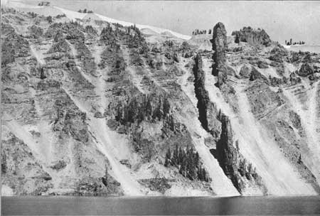
Plate VIII—A. DEVILS BACKBONE.
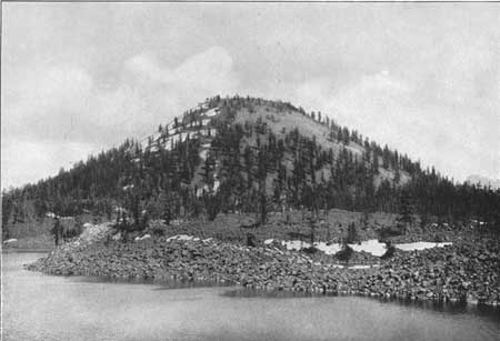
Plate VIII—B. WIZARD ISLAND.
Under the east end of Llao Rock are two dikes, of which the southern one is remarkable. It first appears with a width of 15 feet at the top of a talus slope 100 feet above the lake, and has a vitrophyric border. Upward it thickens slightly as it rises for several hundred feet, then expands into a sheet of lava which was a surface flow on the slope of the growing volcano at the time the dike was formed. At the lower end of the dike No. 95 was collected, and No. 91 represents the adjacent andesite.
A short distance farther northeast is another 15-foot dike, which spreads into a sheet about 500 feet above the lake. The material, although andesite, is rather dacitic (132). It is full of secretions (133) which are somewhat basaltic in their character.
On the west arm of Steel Bay is a 12-foot dike which has a dacitic aspect, but proved under the microscope to be an andesite. About halfway up the rim it expands, connecting with the great flow, 200 feet thick, extending from Llao Rock to the northeast corner of Steel Bay. It fills a fissure in the mountain side from which a large part of the flow escaped. This dike, as well as most of the others, is much older than the one on the Devils Backbone.
No dikes were seen around the northern and southern shore of the lake, but at the southern end of Redcloud Cliff, under the great rhyolite flow of Cloud Cap, three more dikes appear. The one at Sentinel Rock (33) is irregular, 10 to 25 feet in width, with a number of secretions, and for a short distance is cut up into a large mass of conglomerate. Farther north is a 4-foot dike (21) which strikes a little north of east. The transverse jointing in it is especially well developed. It intersects sheets of lava and conglomerate, but does not reach quite to the great flow of dacite above. Almost directly under Cloud Cap is another interrupted dike, trending southeast. Although the dikes noticed thus far are of andesite, and earlier than the great dacite flows, their association with the portions of the rim over which these dacite flows emanated is of interest.
A short distance west of Eagle Cove, about halfway between the crest and the lake, is a 10-foot dike with horizontal jointing. It runs down the slope to the water, and at one point stands out as a prominent ledge 50 feet in height.
Under The Watchman is a dike which reaches neither to the crest nor to the water's edge. It is about 40 feet in width and its border is black and glassy, like the vitrophyric dacite of Llao Rock, but near the middle it appears holocrystalline, within a light-gray color peppered with small dark crystals of pyroxene.
| <<< Previous | <<< Contents >>> | Next >>> |
pp/3/part1-3a.htm
Last Updated: 07-Mar-2006