
|
Geological Survey Professional Paper 715—B
Combined Ice and Water Balances of Maclure Glacier, California, South Cascade Glacier, Washington, and Wolverine and Gulkana Glaciers, Alaska, 1967 Hydrologic Year |
MACLURE GLACIER
DESCRIPTION
Maclure Glacier (lat 37°45' N., long 119°16' W., fig. 1) is a small cirque glacier near the crest of the Sierra Nevada in Yosemite National Park, California. This glacier is 0.5 km long and covers an area of 0.2 km2; the mean ELA (equilibrium line altitude) is 3,650 m. Runoff from the 0.97 km2 basin flows into the Tuolumne River, which flows west into the San Joaquin Valley of California.
FIELD PROGRAM
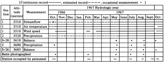
The study at Maclure Glacier began in October 1966 with the construction of a combination gaging station—shelter hut, air temperature and precipitation instrumentation, and the commencement of mass balance measurements. No streamflow record was obtained prior to May 24, 1967; however, it is estimated less than 5 percent of the total runoff occurred from October 1, 1966, to May 24, 1967. Air temperature was recorded at the gaging station shelter by a thermograph attached to the water-stage recorder. The thermograph sensor was located on the north side of the access chimney about 5 m above the ground. Precipitation was recorded near the basin outlet by a water-stage recorder over a storage tank. A nitrogen gas bubbler was used to mix the antifreeze (ethylene glycol) and precipitation to keep it in a liquid state. Many problems were encountered in the first year's operation of the precipitation gage. These problems included recorder insensitivity, clock stoppage, snow blowing into the shelter, and the possibility of the collection orifice bridging over with snow. Because of the poor quality of the record only the total precipitation between visits was determined (table 1). The total precipitation was broken into daily values of rain and snow using the precipitation record from the weather station at Yosemite National Park Headquarters (1,210-m altitude) and the air temperature record at site 1 in Maclure Glacier basin (p. 1A) as guides (pl. 1D). Instrument locations are shown on plate 1A.
TABLE 1.—Instrumentation at Maclure Glacier during the 1967 hydrologic year
|
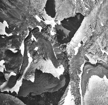
| FIGURE 1.—Vertical aerial photograph of Maclure Glacier and most of the drainage basin, Sierra Nevada, California, October 25, 1966. (North, top of photograph.) |
WEATHER
Most precipitation in this area comes in the form of snow during the winter and spring months (November-April). This precipitation results from the orographic and frontal lifting associated with storms that move in from the Pacific Ocean. The major storms are usually of short duration and of high intensity. A small quantity of precipitation comes from local thunderstorms in the summer months.
Major frontal storms in early December 1966 and late January 1967 were responsible for most of the early winter precipitation. Below normal temperatures in March and April in conjunction with above normal precipitation contributed to a near record snowpack in the central and southern Sierra Nevada. Thunderstorm activity was present in the Maclure Glacier area July, August, and September. The weather station at Yosemite National Park Headquarters (1,210-m altitude) recorded 1.44 m of precipitation during the 1967 hydrologic year. This was 155 percent of the 61-yr average of 0.93 m.
Although air temperatures varied markedly from normal in most winter and spring months, the average temperature for the 1967 balance year (hydrologic year) was near normal at most Sierra Nevada stations. The average air temperature for the station at Yosemite National Park Headquarters was about 1°C (Celsius) above the long-term (61-yr) normal of 12°C The average temperature for the balance year at Maclure Glacier measured at 3,520-m altitude was approximately 0°C.
GLACIOLOGIC BALANCES
The measured winter snow balance,  ms was
determined by measuring the depth of snow and its density in the latter
part of May 1967. The depth of the snow was measured at many locations
over the entire basin; a snow pit was dug and samples taken to determine
the density. These measurements, together with photographs, were used to
draw a contour map (p. 1B) showing lines of equal water
equivalent. The measured winter snow balance was 1.98 m averaged over
the basin and 3.46 m on the glacier. The estimated error (table 2) in
these values is high for several reasons. The extremely deep snowpack in
1967 made depth sounding difficult, some areas in the basin were
inaccessible because of the steep slopes, and inconsistent depth
soundings were obtained in some non-glacier covered areas because of the
loose rock debris under the snow. The high values (greater than 5 m) for
accumulation on the upper portion of the glacier are believed to be
caused in part by snow blowing into the basin from the south—a
normal mode of accumulation on small cirque glaciers.
ms was
determined by measuring the depth of snow and its density in the latter
part of May 1967. The depth of the snow was measured at many locations
over the entire basin; a snow pit was dug and samples taken to determine
the density. These measurements, together with photographs, were used to
draw a contour map (p. 1B) showing lines of equal water
equivalent. The measured winter snow balance was 1.98 m averaged over
the basin and 3.46 m on the glacier. The estimated error (table 2) in
these values is high for several reasons. The extremely deep snowpack in
1967 made depth sounding difficult, some areas in the basin were
inaccessible because of the steep slopes, and inconsistent depth
soundings were obtained in some non-glacier covered areas because of the
loose rock debris under the snow. The high values (greater than 5 m) for
accumulation on the upper portion of the glacier are believed to be
caused in part by snow blowing into the basin from the south—a
normal mode of accumulation on small cirque glaciers.
TABLE 2.—Ice and water balances, Maclure Glacier basin, 1967 hydrologic and balance years
[Values and errors in metres water equivalent expressed as averages over the glacier and basin except where indicated. Date: Hydrologic year, Oct. 1, 1966 (t0) through Sept. 30, 1967 (t1)]
| Glacier |
Basin |
Date | Term | Explanation | |||
| Value | Error | Value | Error | ||||
Yearly mass balances | |||||||
| a |
1.05 | 0.01 | 0.37 | 0.05 | Hydrologic year | Annual balance | Total change in snow, firn, and ice storage during the 1967 hydrologic year, from t0 to t1; approximately equal to difference between precipitation as snow and melt-water runoff for the hydrologic year. |
| n |
1.10 | .10 | .39 | .05 | Oct. 20, 1966 to Oct. 15, 1967 | Total mass net balance | Change in storage from the minimum balance in 1966 autumn (t0') to the minimum in the 1967 autumn (t1'). |
| a(fi) |
1.10 | .10 | .39 | .05 | do | Firn and ice net balance | Change in firn and ice storage between two consecutive summer surfaces. |
Accumulation and ablation | |||||||
| m(s) |
3.46 | 0.20 | 1.98 | 0.20 | May 24, 1967 | Measured winter snow balance | Snowpack on the 1966 summer melt surface (ss0); measured in late winter or spring in pits and by probing. |
| x |
3.35 | .20 | 1.91 | 0.20 | May 14, 1967 | Maximum balance | Storage change from the beginning of the hydrologic year
(t0) to the maximum in the spring. Winter balance (bw)
equals maximum balance (x) plus the absolute
value of the initial balance increment (0). |
| a(f) |
1.28 | .10 | .40 | .05 | Oct. 15, 1967 | Net firnification | The increment of new firn in the accumulation area at t1, measured after melting ceases in the autumn. |
| a(i) |
-.18 | -.01 | -.01 | -.01 | do | Net ice balance | Ice and old firn melt in the ablation area during the 1967 melt season. |
 a a |
3.46 | .25 | 1.98 | .20 | Hydrologic year | Annual accumulation | Total accumulation of snow between t0 and t1. |
 a a |
2.41 | .25 | 1.61 | .20 | do | Annual ablation | Total ablation of snow, ice, and old firn between t0 and t1. Approximately equal to the difference between annual rainfall and runoff. |
Values relating annual and net ice balances | |||||||
| 0 |
-0.11 | 0.03 | -0.07 | 0.01 | Oct. 1-20, 1966 | Initial balance increment | Storage change between time of minimum in 1966 autumn (t0') and beginning of hydrologic year (t0). |
| 0(s) |
0 | 0 | 0 | 0 | Initial snow balance | Snow accumulated on the 1966 summer surface (ss0) at beginning of hydrologic year (t0); measured in pits and by probing. | |
| i |
-.11 | .03 | .02 | .01 | Oct. 1-20, 1966 | Initial ice balance | Initial ice balance Ice and old firn melt after t0 and before the winter snowpack covers the glacier; measured by ablation stakes. |
| 1 |
-.06 | .02 | -.05 | .02 | Oct. 1-15, 1967 | Final balance increment | Storage change between time of minimum in 1967 autumn and the end of the hydrologic year. |
| 1(ls) |
0 | 0 | 0 | 0 | Final late snow balance | Snow accumulated on the 1967 summer surface (ss1) at t1. | |
| 1i |
-.01 | .01 | 0 | 0 | Oct. 1-15, 1967 | Final ice balance | Ice and old firn melt after t1 and before the next year's snowpack covers the glacier. |
Glacier and basin dimensions | |||||||
| S(fi) | 10.17 | 0.02 | 0.18 | 0.02 | Oct. 15, 1967 | Glacierized area | Glacier value includes firn and ice areas which normally are attached to the main trunk glacier. Basin value is the main glacier plus all other small glaciers and perennial snowfields in the drainage basin. Ice-cored moraine and other permafrost areas are not included as glacierized areas. |
| S | 1.17 | .02 | .97 | .01 | do | Total area | Glacier and water drainage basin above the stream gaging station. |
| AAR | 2.86 | .03 | .39 | .03 | do | Accumulation area ratio | Area of new firn, accumulation area, divided by the total area. An index of annual balance. |
| ELA | 3,640 | 5 | do | Equilibrium line altitude | Average altitude where snow ablation equals snow accumulation. An index of annual balance. | ||
| δL | 5 | 3 | Hydrologic year | Advance or retreat | Average horizontal distance change of terminus of the glacier in direction of flow. | ||
Precipitation and runoff | |||||||
| pa | 2.03 | 0.50 | Hydrologic year | Gaged annual precipitation | Total snow and rain caught during the hydrologic year by a shielded gage at 3,520-m altitude. | ||
| pa(r) | .14 | .05 | do | Gaged annual precipitation as rain | Precipitation occurring as rain caught during the hydrologic year by the same gage at 3,520-m altitude. | ||
 a a |
3.60 | 0.21 | 2.12 | .21 | do | Annual basin precipitation | Area averaged snow and rainfall measured during the hydrologic year by precipitation gages and snow balance measurements. |
| a(r) |
.14 | .06 | .14 | .06 | do | Annual basin precipitation as rain | Area averaged rainfall measured by gages during the hydrologic year. Rain distinguished by air temperature records, visual observations, and photographic record. |
| pa* | 3.44 | .28 | 1.97 | .10 | do | Calculated annual precipitation | Area average annual snow and rain precipitation; the sum
of annual stream runoff and annual storage change
(a). |
 a a |
2.39 | .15 | 1.60 | .09 | do | Annual runoff | Stream discharge for the year divided by glacier or basin area, expressed as average depth of water over the area; measured by stream stage recorder and stream discharge measurements. |
1Square kilometres. 2Dimensionless. | |||||||
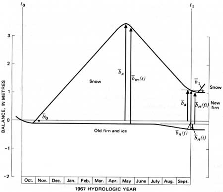
The annual balance, a, was determined by combining measurements
of the depth and density of the snow remaining at the end of the summer
season, n(f), and by measurement of the amount of
ice and firn ablation during the summer season, n(i), and using the adjustment
terms 0 and
1 (a = 0 + n(f) + n(i) - 1). A positive
annual balance was found for both the basin (0.37 m) and the glacier
(1.05 m). It is interesting to notice that for the 1967 hydrologic year
almost one-half of the old firn and ice ablation occurred in the first 3
weeks of October 1966 (fig. 2). Due to the above normal winter and
spring precipitation, 86 percent of the glacier was still covered by
snow at the end of the summer season. These annual balance figures are
considered to be more accurate than the winter balance figures (table 2)
because the annual balance can be more easily measured. Photographs are
helpful in determining the extent of residual snow in accessible
areas.
|
| FIGURE 2.—The balance of Maclure Glacier, 1967 hydrologic year. (Refer to table 2 for additional values.) |
Because of the small size of this glacier and
cessation of melting soon after the end of the hydrologic year, the
stratigraphic and annual balance changes are nearly synchronous. Values
relating annual and net balances (table 2) were small, and only a few
correction factors are necessary (table 2). The slight difference
between the annual and net balance is due to the difference between 0 and 1, a reflection
of the higher melt rates in October 1966 than in October 1967. Figure 2
illustrates the mass balance values that were measured and some
important calculated values.
HYDROLOGIC BALANCE
Basin runoff during the hydrologic year totaled 1.60
m (1.51 m measured, plus 0.02 m estimated during the winter months, plus
0.07 m between Oct. 1 and Oct. 20, 1966). The source of this runoff was
approximately 1 percent ice melt, 22 percent glacier snowmelt, 69
percent nonglacier snowmelt, and 8 percent rain. The sum of the
components (0 + x = a + a(r)) serves as an independent
check on runoff; they gave 1.75 m, or 0.15 m more runoff than indicated
by streamflow. This difference is within the limits of estimated errors
for all the parameters entering into the calculation.
The recording precipitation gage located near the
mean altitude of the drainage basin gave a value of 2.03 m for the year.
This is slightly larger than the calculated precipitation, a*,
as determined by runoff and ice storage changes.
| <<< Previous | <<< Contents >>> | Next >>> |
pp/715-B/sec2.htm
Last Updated: 28-Mar-2006