|
Geological Survey Professional Paper 754-A
Glacial and Postglacial Geologic History of Isle Royale National Park, Michigan |
MODIFICATION OF TOPOGRAPHY BY GLACIAL DEPOSITION
GENERAL DISTRIBUTION OF GLACIAL DEPOSITS
Many workers have commented upon the scarcity of glacial drift on the east end of the island as compared with that on the west end (Desor in Foster and Whitney, 1850, p. 200; Lane, 1898, p. 182; Stanley, 1932, p. 20; Zumberge, 1955, p. 154). Lane (1898, p. 183) noted that he had "not been able to recognize any material as morainal, that is, deposited by the ice directly, and not rehandled by water, although such may occur on the lee sides toward the southwest of the island buried under rehandled material." During the present study a complex of ice-margin deposits was recognized near the west end of Isle Royale; the nature and distribution of glacial deposits on the island appears to be closely related both to direction of ice movement and to proximity to the ice margin.
On the east half of Isle Royale, where the last ice advance moved approximately parallel with the ridge-and-valley topography, surficial deposits other than talus and slope wash are confined to valleys and smaller depressions, and constructional features of glacial origin are not apparent; outcrops are relatively abundant except in the valleys. Scattered erratics indicate the presence of glacially transported materials, but are not abundant. Beach gravels along the present shoreline are predominantly of locally derived materials. But even at the east end of the island, the beaches contain numerous pebbles, some exotic, reworked from glacial debris. The pebbles most obviously exotic are of granitic rocks from the Canadian mainland and fossiliferous limestone and chert from the Hudson Bay basin.
Near the west end of Siskiwit Lake, where the direction of ice movement was westward and crossed the trend of the ridge-and-valley forms at an angle of about 25° glacially deposited materials become more abundant; thin till mantles many of the slopes, and outcrops decrease in size and number. Large erratics are numerous.
Till is abundant on the west end of the island, effectively mantling most of the bedrock and subduing the landforms (fig. 3). Large erratics also are abundant (fig. 8). Outcrops are limited mainly to small but prominent knobs and the steep north faces of some ridges. In many places these exposures have clearly been excavated by wave action during lake stages higher than the present level of Lake Superior. It is on this west, till-covered end of the island that the abandoned shorelines of higher lake levels, discussed in a later section, are so well developed.

|
| FIGURE 8.—Granitic erratic near summit of Feldtmann Ridge (near site of abandoned lookout tower). |
DRUMLINS
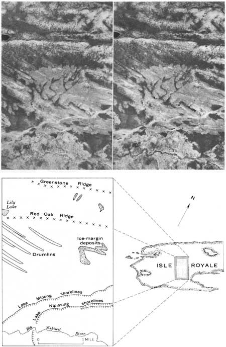
As the amount of till increases west of Siskiwit Lake, constructional glacial deposits, including drumlins, become apparent. The drumlins range in length from a few feet to nearly 2 miles; the larger ones can be seen on the shaded-relief map (fig. 3) and on aerial photo graphs (fig. 9) as distinct east-west ridges superimposed upon the bedrock-controlled, northeast-trending ridges. They are most abundant between the west end of Siskiwit Lake and a locale about 5 miles east of Cumberland Point. The drumlins are of the crag-and-tail variety—linear ridges of glacial debris streamed out behind a bedrock knob in the direction of glacial transport. Although outcrops are not visible at the noses of all such features, enough have been seen to suggest that all are of similar origin. In an area west of Siskiwit Bay covering several square miles, the only bedrock present crops out at the heads of these linear till deposits (fig. 9). Glacial striations and drumlins indicate the same direction of ice movement in all cases where both are present.
ICE-MARGIN DEPOSITS
A series of ice-margin deposits, built during a pause in the retreat of the last ice sheet, crosses the island in a northerly direction west of Lake Desor. These deposits define an irregular ice front, controlled by topography, with tongues of ice extending into valleys or low areas in front of the main ice mass. Nested deposits on the south side of Greenstone Ridge indicate a sporadic withdrawal of the ice lobe that extended up the drainage basin of the Little Siskiwit River. Two deposits on the north side of the Big Siskiwit River lowland also may indicate successive stages of withdrawal. In the western most of these deposits, there is a small kettle similar to those on Mount Desor noted by Stanley (1932, p. 42).
It is not known if the glacial debris making up the ice-margin deposits shows any sorting or layering, and it is thus uncertain whether the deposits are recessional moraines, kame deposits, or other types of glacial deposits typically formed near the edges of ice sheets. Their physiographic form is distinctive, however, and can be generally characterized as consisting of arcuate ridges roughly transverse to the direction of ice movement, as indicated by striations and drumlins, and not controlled by bedrock structure. Although all ice-margin deposits shown on the map were visited, their geographic extent has been largely determined from topographic form as seen on aerial photographs. Other small related deposits may be present, but none are readily apparent on the aerial photographs, as the part of the island where the deposits occur has an especially heavy timber cover.
| <<< Previous | <<< Contents >>> | Next >>> |
pp/754a/sec5.htm
Last Updated: 01-Mar-2005
