|
California Division of Mines and Geology
Bulletin 182 Geologic Guide to the Merced Canyon and Yosemite Valley, California |
GEOMORPHOLOGY OF THE YOSEMITE VALLEY REGION, CALIFORNIA*
By CLYDE WAHRHAFTIG
U.S. Geological Survey, Menlo Park, California
and University of California, Berkeley, California
*Publication authorized by the Director of the U.S. Geological Survey.
INTRODUCTION
Yosemite Valley lies in the Sierra Nevada, a strongly asymmetric mountain range with a broad gentle western slope that rises about 13,000 feet in a distance of 60 miles (200 feet per mile) and an abrupt eastern escarpment that drops 5,000 to 6,500 feet in 5 to 8 miles (about 1,000 feet per mile). The eastern escarpment is the result of displacement in later Tertiary and Quaternary time along a complex system of en echelon and step faults, interspersed with ramps and tilted structures (Lindgren, 1911, p. 39-49; Matthes, 1930, p. 24-25; P. C. Bateman, written communication, 1960; Rinehart and Ross, in press). The western slope, the back slope of the tilted fault block that is the Sierra Nevada, is a broad upland surface of moderate local relief—generally less than 2,500 feet—into which west-flowing streams have incised narrow steep-walled canyons 1,000 to 7,000 feet deep. Yosemite Valley is the headward segment of one of these canyons—that of the Merced River—somewhat widened and greatly deepened by glacial erosion.
The geomorphic history of the Yosemite Valley—and of the western slope of the Sierra Nevada on which it lies—involved: (1) the development of the upland surface; (2) tilting of that surface and carving of deep canyons; and (3) modification of the headward parts of these canyons by glaciers.
UPLAND SURFACE OF THE SIERRA NEVADA
The upland surface of the Sierra Nevada has had a long and complicated history, which is as yet imperfectly understood. Much of the evidence for this history lies in the northern part of the range, where the crystalline bedrock is overlain by a complex of Cretaceous and younger formations, called the Superjacent series by Lindgren and Turner (1894); other evidence lies in the Great Valley of California, where much of the material eroded from the Sierra Nevada was deposited.
Parts of the upland surface may be as old as middle Cretaceous. It is probable that most of the erosion that led to the exposure of the Jurassic and Cretaceous granitic rocks of the Sierra Nevada was accomplished before Late Cretaceous time, for along the western margin of the northern Sierra scattered patches of the fossiliferous marine sandstone of the Upper Cretaceous Chico formation rest on an irregular surface of moderate relief cut on granite and other basement rocks. This sandstone dips southwestward at angles of 2° to 4° (Lindgren, 1911, p. 22-23; Allen, 1929, p. 368; Creely, 1955, p. 96-117). Apparently the shoreline of the Late Cretaceous sea coincided closely with the present edge of the Great Valley sediments, for the Cretaceous rocks north of Oroville appear to correlate with coarse river-channel deposits in the foothills immediately to the east (Creely, 1955, p. 96-117). Wells 10 miles west of the edge of the foothills have encountered, at depths of a few thousand feet below the surface, 2,000 to 5,000 feet of rocks correlated with the Chico formation (Creely, 1955, pl. 3; Piper and others, 1939, p. 87; Davis and Hall, 1959, pl. 3).
The Eocene Ione formation and its correlative rocks, the auriferous gravels, indicate with certainty that by early Tertiary time the granitic rocks of the Sierra Nevada had been exposed to about their present depth, and that the mountain range that resulted from the orogeny that accompanied the intrusion of the granites had been reduced to a surface of moderate to low relief. The Ione formation consists of interbedded quartz sand, kaolin clay, kaolinitic sandstone, and thin beds of lignite, that dip 2° to 5° westward along the base of the Sierra Nevada, and that rest on deeply weathered metamorphic and igneous rocks, or on a deep-red to chalk-white tropical soil developed on these rocks (Allen, 1929). The formation is predominantly continental, but at Merced Falls and elsewhere it contains intercalated sandy beds with marine fossils, indicating that the shoreline of the sea was then close to the present base of the Sierra Nevada (Allen, 1929). At the time the Ione accumulated California had a humid tropical climate, in which laterites and kaolin were formed; at other times in the Cretaceous and Tertiary the climate of California appears to have been cooler, for montmorillonite rather than kaolinite is the common clay mineral of the other sedimentary formations, and feldspar is a common constituent of their sandstones.
|
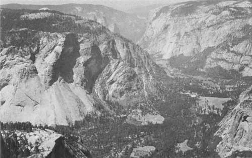
| Photo 1. View of Yosemite Valley from the top of Half Dome, showing the sheer valley walls incised into the gently rolling upland surface of the Sierra Nevada. The cliff at the left is Glacier Point, its unjointed lower part composed of Half Dome quartz monzonite, and the upper part, broken by vertical joints, of Sentinel granodiorite. The Glacier Point hotel can be seen at the tap of the cliff. Sentinel Dome is the white dome rising from the forest directly above the hotel. El Capitan is the cliff on the north wall of the valley opposite the Cathedral Racks. Washington Column is in the extreme lower right. Photo by U.S. National Park Service. |
The auriferous gravels, which grade into the Ione formation along the western margin of the foothills (Allen, 1929, p. 395-402; Creely, 1955, p. 142-163; Lindgren, 1911, p. 33-37, 40, 86-89), were presumably laid down as stream gravels in a series of well-defined channels or valleys that coursed down the western slope of the Sierra Nevada (fig. 1). Remnants of these deposits now lie on broad spurs between the present west-flowing streams, having been preserved beneath cappings of lava or volcanic mudflows. Because much placer gold was obtained from these gravels during the last century by hydraulic and drift mining, we know a great deal about their extent (Lindgren, 1911). The streams by which they were deposited no longer exist—the drainage pattern of that period was completely buried by later outpourings of volcanic debris—but we know that in general these streams flowed westward from sources near the present crest of the Sierra Nevada, or even farther east. The minimum local relief of the Sierra Nevada at that time in the present foothill region, as estimated from the present height of hills of bedrock above nearby segments of the Tertiary river channels, was about 1,500 to 2,500 feet (Turner and Ransome, 1897 and 1898; Turner, 1894; Lindgren, 1911, p. 37-39, 197-199, 218-219). According to Lindgren (1911, p. 37-39) the Tertiary topography consisted of three elements: a discontinuous line of abrupt ridges 1,000 to 2,500 feet high, extending northwestward near the present foothills and held up by resistant metavolcanic rocks (Logtown Ridge, Gopher Ridge and Bear Mountain, Penon Blanco, and Mount Bullion, fig. 1); northeast of these ridges, a broad northwest-trending valley cut in the soft slates of the Mother Lode belt; and still farther northeast, a rolling plateau cut chiefly on granitic rocks, in which broad Eocene valleys were incised 800 to 2,000 feet.

|
| FIGURE 1. Tertiary river channels of the Sierra Nevada. (click on image for a PDF version) |
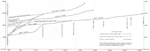
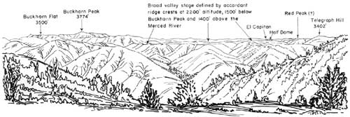
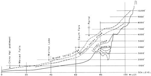
The Merced River is not bordered by Eocene river gravels, so we do not know what its profile was in early Tertiary time; the blanket of volcanic debris, which preserved the auriferous gravels north of the Tuolumne River apparently did not extend as far south as the basin of the Merced. Matthes (1930, p. 31-50), however, was able to reconstruct the early landscape along the upper Merced River by a study of the present topography. He noted that the upper reaches of lateral tributaries of the Merced River flow with gentle gradient in broad shallow valleys to an abrupt nickpoint, from which their lower courses cascade to the Merced River, which is incised in a narrow canyon several hundred to 3,000 feet below the level of those valleys (fig. 2). By projecting the profiles of the tributaries downstream to the points where they joined the Merced, he was able to reconstruct the profile that the upper part of the river followed at this early stage in the Yosemite region; and Hudson (1960, p. 1554-1557) has now extended this profile down to the Great Valley (fig. 3). The reconstructed profile defines a broad valley incised 800 to 1,500 feet below adjacent mountains such as Half Dome, and having about the same depth as the Eocene valleys farther north. It therefore seems reasonable to assume that most of the cutting of the broad valley took place during or before the deposition of the auriferous gravels in the northern Sierra Nevada.*
*Hudson, on the other hand (1960, p. 1555), places the Broad Valley stage of downcutting in the late Pliocene. Piper and others (1939, p. 78) correlate it with the Valley Springs formation of late Miocene (?) age.
|
| FIGURE 3. Longitudinal profiles of the Merced River (after Hudson, 1960, p. 1551). (click on image for a PDF version) |
The Ione formation and the auriferous gravels are overlain by extensive bodies of white rhyolite tuff and associated gravel, which constitute what is called the Valley Springs formation (Allen, 1929, p. 410-419; Piper and others, 1939, p. 71-80). These are dated as probable late Miocene (Davis and Hall, 1959, p. 9). The eruptions that produced the rhyolitic debris initiated the volcanic outpourings that buried the Eocene surface of the northern Sierra Nevada. The relief of this surface may have been reduced by erosion of its more upstanding portions in Eocene, Oligocene, and Miocene time, but the surface itself could not have been uplifted and dissected at that period, for Eocene gravels of the rivers that drained that surface are preserved beneath the Miocene and Pliocene volcanic cover.
The most extensive volcanic outpourings in the northern Sierra Nevada occurred in late Miocene or early Pliocene time (Piper and others, 1939, p. 61-71; Lindgren, 1911, p. 31-33). These constitute the Mehrten formation of Miocene and Pliocene age, a deposit of andesitic volcanic mudflows interbedded with conglomerate and sandstone that consist mainly of andesitic debris. The Mehrten formation has been correlated with the Neroly formation of the San Pablo group in the northern Diablo Range (Davis and Hall, 1959, p. 9). The sources of the volcanics in the Mehrten are breccia dikes along the present crest of the Sierra, from which they were largely extruded in the form of breccia (Curtis, 1954). The eruptions buried the northern part of the range under a volcanic blanket that was about 1,500 feet thick at the west foot of the mountains and 4,000 or 5,000 feet thick along the crest of the range, and that completely obliterated the old drainage of the Sierra Nevada. A new westward-flowing drainage was then developed upon the constructional surface of the volcanic rocks (fig. 1). The southernmost of the mudflows of the Mehrten formation followed the course of the Tuolumne River (Lindgren, 1911, p. 30-32, 218-219). None reached the Merced drainage, so the Merced today is probably in about the same place that it was in early Tertiary time.*
*For the distribution of the Mehrten formation beneath the Great valley, and its probable influence on the lower course of the Merced River, see the paper by R. J. Arkley in this guidebook.
EROSION OF THE MERCED CANYON
Matthes (1930, p. 31-50), in his restoration of the ancient profiles of the Merced River, recognized two stages in the cutting of the Merced canyon, which followed the Broad Valley stage. His determination of the profiles of these stages was based on the same technique that he used for the Broad Valley stage, but here he used intermediate segments of the tributary streams, with nickpoints at their upper and lower ends (see figs. 2 and 4 for examples of the profiles). During the earlier of these stages, which he called the Mountain Valley stage, the river flowed in a fairly rugged narrow valley, 1,600 to 2,200 feet below the surrounding uplands and about 600 feet below the level of the Broad Valley stage. The later stage, which he called the Canyon stage, determined the present level of the Merced River in the unglaciated canyon below El Portal and also determined the original preglacial profile in the glaciated part of the canyon above El Portal. The cutting of the China Hat and Arroyo Seco pediments, described by R. J. Arkley in this guidebook, may have occurred during the Mountain Valley and Canyon stages.
UPLIFT AND TILTING OF THE SIERRA NEVADA
The Merced River and other west-flowing streams of the Sierra Nevada cut their deep canyons because the range as a whole was uplifted and tilted to the west. Estimates made by several men of the amount, nature, and time of this deformation differ widely, partly, no doubt, because they have been based on different kinds of evidence.
The direct estimates involve determination of the amount of deformation of the bedrock profiles of the early Tertiary rivers. The present deformed profiles, determined either from the slope and altitude of channel segments beneath the gold-bearing gravels or by reconstruction from existing topography, have been determined with fair accuracy. The original profiles, from which deformation to the present is measured, must in large part be reconstructed from our knowledge of the factors that control the gradients of debris-carrying streams. Recent investigations on this general problem (Leopold and Maddock, 1953, p. 48-51; Leopold and Wolman, 1957; Hack, 1957, p. 53-74) indicate that the auriferous gravels will have to be studied further before these original profiles can be reconstructed with a precision that is up to modern standards.
Indirect estimates of the deformation include (1) inferences drawn from fossil floras regarding former climates, (2) measurements of displacement on the faults along the east side of the range, and (3) measurement, through subsurface investigations, of the tilting of sedimentary rocks in the eastern half of the Great Valley. The bearing of the second and third lines of evidence is open to question, for neither the faulting on the east side of the range nor the tilting of the sediments in the Great Valley was necessarily quite contemporaneous with the uplift and tilting of the mountains between them, or of the required magnitude; their aggregate effect may have been either greater or less than that. This section, therefore, will merely describe the views of several writers regarding the amount and time of this deformation without attempting to choose between them.
|
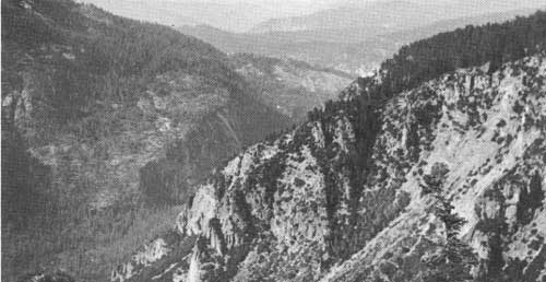
| Photo 2. View dawn the lower Merced Canyon from the top of El Capitan. The canyon is incised in valleys of the Broad-Valley and Mountain-Valley stages of canyon cutting; these stages are indicated by the gentle slopes descending to broad flats from the surrounding level ridge taps. Photo by F. C. Calkins, U.S. Geological Survey. |
Lindgren (1911, p. 46) concluded that the Sierra Nevada had been tilted essentially as a rigid block, although he recognized several faults with as much as 500 feet of displacement cutting the auriferous gravels on its western slope. He determined (1900, p. 10) that the tilting at the latitude of Donner Pass amounted to between 60 and 70 feet per mile, which corresponds to an uplift at the crest, now 7,500 to 8,000 feet above sea level, of about 4,500 or 5,000 feet. In his opinion this uplift took place during the eruption of the volcanics which constitute the Mehrten formation, that is, in Miocene and Pliocene time.
Lindgren based his calculations largely on the bedrock profile of the Tertiary Yuba River, which apparently flowed southwestward from the crest of the range for about 35 miles, then turned to flow northwestward, parallel to the presumed axis of tilting, for about 45 miles, and turned again to flow southwestward for about 30 miles to a mouth near the present site of Wheatland, at the east side of the Sacramento Valley. The gradients of the reconstructed southwesterly reaches are 80 to 100 feet per mile, and those of the northwesterly reaches 20 to 30 feet per mile (Lindgren, 1911, pl. 10). Lindgren assumed that the northwest reach had not been tilted and therefore had the average gradient of the stream before tilting; he estimated the tilting, by subtraction, to be between 60 and 70 feet per mile.
Matthes (1930, p. 44), using a similar method on the reconstructed profiles of the Merced River, but with more assumptions since there were no long northwest-flowing reaches of that stream, concluded that total tilting since the Broad Valley stage, which he placed at the end of the Miocene, had amounted to 72 feet per mile, and that the total uplift of the crest of the Sierra Nevada in Yosemite National Park had been 9,000 feet. He estimated that 6,000 feet of the uplift, and tilting of 60 feet per mile, had occurred since the end of the Mountain Valley stage, which he placed at the end of the Pliocene. The floor of Yosemite Valley was, he inferred, 800 feet above sea level during the Broad Valley stage and 1,800 feet above sea level in the Mountain Valley stage.
Hudson (1955, 1960) has calculated the amount of tilting in the Sierra Nevada through use of the present gradients of differently directed adjacent reaches of the Tertiary streams, taken in groups of three. He assumes that the average gradient in all three adjacent reaches was originally the same, and computes the amount and direction of tilting necessary to produce the present gradients by solving three equations for three unknowns: the original gradient, the amount of tilting, and the direction of tilting. From these computations he has concluded that the Sierra Nevada was deformed not as a rigid block but in a very complex fashion, and, furthermore, that the total uplift at the crest has amounted to less than 2,000 feet in the Lake Tahoe-Donner Pass region and less than 4,000 feet in the Yosemite National Park region. From correlation of the Broad Valley stage of the Merced River with the China Hat pediment (Arkley, this guidebook) Hudson (1960, p. 1559-1560) places the uplift and deformation entirely within post-middle-Pliocene time.
Axelrod (1957) has shown that floras of Miocene and Pliocene age from the Valley Springs formation, the Mehrten formation, and their equivalents in west-central Nevada indicate similar climates, and that they do not indicate the existence of a rain shadow, such as the one now present on the east side of the Sierra Nevada. From his estimates of the range in altitude of the floras, he concludes that the mountains near Lake Tahoe could not have been higher than 2,000 or 2,500 feet in Miocene and Pliocene time, and therefore that the crest of the range has been uplifted 5,000 to 6,500 feet since then. There seems at present to be no way of reconciling Axelrod's views with those of Hudson.
Hoots, Bear, and Kleinpell (1954, pl. 6) show that in the Chowchilla-Merced area of the Great Valley, just south of the Merced River, the base of the Pliocene sediments slopes about 100 feet per mile west-southwestward. In their cross sections, the base of the Pliocene and the base of the Eocene are essentially parallel. If the evidence in the Great Valley can be projected eastward to the Sierra Nevada, one may infer from it that there was no tilting of the range from middle Eocene to Pliocene time, and tilting on the order of 100 feet per mile since Pliocene time. As stated above, however, it has not yet been proved that tilting in the Sierra Nevada was contemporaneous with that in the Great Valley or equal to it in amount.
Somewhat similar evidence is found between Mono Lake and Bishop on the east side of the Sierra Nevada. According to Blackwelder (1931, p. 904) and C. D. Rinehart and D. C. Ross (oral communication), there has been about 3,000 feet of displacement on faults on the east side of the Sierra Nevada since the McGee stage of glaciation. Vertical displacements at least as great as this in the region immediately east of the fault have resulted in deformation of the Bishop tuff of Gilbert (1938), a glowing-avalanche deposit that rests on glacial till at least as old as the Sherwin stage; and that has been dated by the potassium-argon method as about one million years old (Evernden and others, 1957). This tuff, whose upper surface must originally have been nearly horizontal, now ranges in altitude from about 8,000 feet just south of Mono Lake to 3,300 feet in the alluvial sediments south of Bishop (Gilbert, 1938; Bateman, 1956, pl. 1, 2 and oral communication, 1957; Rinehart and Ross, 1957, and oral communication, 1960). The deformation just east of the Sierra Nevada may have taken place long after the tilting and uplift of the range was completed; it may represent the collapse of the Owens Valley-Mono Lake block, which may have involved either greater or less displacement than the uplift of the range.
While the dates arrived at by these indirect means thus differ considerably, the writers quoted all place the major uplift and tilting of the range in late Pliocene and early Pleistocene time. In regard to the total amount of uplift, their estimates tend to agree more nearly with those of Lindgren and Matthes than with those of Hudson.
GLACIAL EROSION OF THE YOSEMITE VALLEY
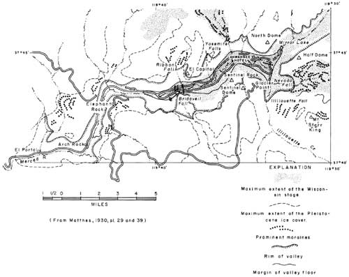
In the summer-dry Mediterranean climate of California, the present snowfall on even the highest areas in the Yosemite National Park is barely sufficient to maintain a few small cirque glaciers on the shaded north sides of 12,000- to 13,000-foot peaks. During the maximum extent of Pleistocene glaciation, however, snow accumulated on ridges no more than 9,500 feet high, and, except on slopes that were too steep, the surfaces above that altitude were blanketed with snow and ice. The glaciers fed by these snowfields descended about 25 miles down the Merced Canyon to El Portal and beyond, reaching altitudes as low as 2,000 or even 1,700 feet; they also went down the Tuolumne Canyon to like altitudes and for a distance of about 40 miles. At its maximum extent the Merced Glacier completely filled Yosemite Valley and spilled slightly over the rim onto the uplands on either side (Matthes, 1930, p. 50-102) (fig. 5).
|
| FIGURE 5. Sketch map of Yosemite Valley, showing extent of glacial ice. (click on image for a PDF version) |
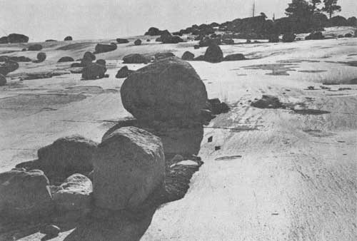
Glaciers advanced down the Merced Canyon at least three and perhaps four times. During the later stages of glaciation, ice only partially filled the Yosemite Valley, and glaciers of the latest major stage, the Tioga, did not even reach the valley but stopped just short of Nevada Falls (Blackwelder, 1931, p. 907). Little remains of the oldest moraines except scattered boulders of quartzite, schist, and other highly resistant rocks; any boulders of intrusive rocks that can still be identified are mostly decomposed to gruss (granite sand), and the bedrock surfaces on the uplands that were glaciated have weathered down several inches or several feet, leaving glacial erratics perched on pedestals of disintegrated bedrock. The deposits of the youngest glaciation, on the other hand, are quite fresh, and large areas of bedrock that were covered by the latest glacier are so little weathered that the glacial polish on them still glistens in the sunlight. The stages of glaciation of the Yosemite region that have been recognized by various authors are shown in table 1.
Table 1. Correlation and characters of glacial stages in Yosemite Valley.
| Glacial stages | Position of ice terminus on Merced River |
Weathering (after Birman, 1957, p. 55) | |||
| Matthes (1930) |
Blackwelder (1931, p. 907-908) |
Birman (1957, p. 220-222) |
Till | Bedrock | |
| "Little ice age" (Matthes, 1942, p. 214) (2,000 B.C. to present) | Matthes Recess Peak Hilgard(?) |
Cirques on Mt. Lyell (includes modern glaciers). | Unweathered (unstable on most recent moraines.) | (Glacial polish completely preserved.) | |
| Wisconsin | Tioga | Tioga | Head of Nevada Falls. | Moraines fresh, undissected. | Not much weathering of bedrock; much polish preserved. |
| Tahoe | Graveyard | Foot of Bridalveil Falls. | Moraines moderately weathered; dissected by gullies 10 to 40 ft. deep. | Little or no erosion of bedrock; polish preserved only on aplite pegmatite, and fine volcanics. | |
| El Portal | Sherwin? | Tahoe | Few miles west of El Portal. | Moraines weathered to 10 ft.; dissected by gullies 10 to 70 ft. deep. | Boulders perched 1 in.; pegmatite dikes protrude 3 in. Much weathering on surface; weathering pits rare or shallow. |
| Glacial Point | Sherwin | Bedrock weathered to 6 in. below surface and weathering pits 6 in. deep. | Most boulders weathered; no morainal forms preserved. | ||
| McGee | McGee | (Not recognized on west slope of Sierra.) | Rock pedestals and mafic inclusions more than 6 in. high. | ||
|
| Photo 3. Glacial polish, glacial striae, and erratics on Moraine Dome, Little Yosemite Valley. Photo by Ralph H. Anderson, U.S. National Park Service. |
The glaciers profoundly changed the shape of the original Merced Canyon. They ground off projecting spurs, planed back parts of the walls to vertical cliffs, gouged a deep basin in the valley floor, and gave the valley the characteristic U-shaped cross-profile. According to Matthes (1930, p. 89-98) the glaciers eroded mainly by quarrying and plucking, joint blocks being lifted into the glacier by freezing of water in the cracks between them. Grinding and polishing appear to have played a relatively minor part in the erosion of the valley. Matthes has shown that the greatest deepening and widening of the valley occurred where the rocks were most closely jointed, and that many of the massive, almost unjointed monoliths were eroded slowly or not at all. As was pointed out in the paper in this guidebook by Calkins and Peck, the various intrusive rocks in which the canyon was cut differ widely in the extent to which they are jointed, and the more mafic rocks are in general more closely jointed than the more siliceous rocks. Joints are indeed scarcest in the Half Dome quartz monzonite, which is less siliceous than the granites in El Capitan, but this may be because it forms an exceptionally large intrusive body. Some depressions were eroded, however, along fissures that cut indifferently across all kinds of rocks, even across Half Dome quartz monzonite. Where the Merced Canyon was cut into rocks in which the joints are widely spaced, as it is in the gorge between El Portal and the mouth of Cascade Creek, its cross profile is still essentially V-shaped, although morainal deposits on the walls of the gorge show that it was occupied by the earlier ice. The relatively even longitudinal profile of the preglacial Merced River was converted by glacial plucking into a series of giant steps separating glacially scoured basins, the nearly vertical steps occurring where massive unjointed rock crosses the canyon.
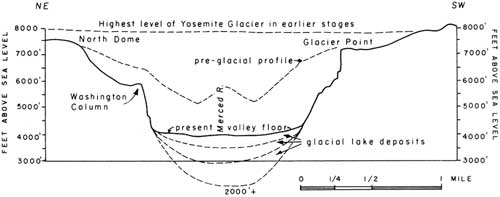
The proportionate amounts of erosion accomplished in the preglacial canyon stage and during glaciation are indicated by the cross-profiles, (figs. 4 and 6), in which Matthes' reconstructions of the canyon stage of the Merced River are superimposed on the present bedrock profile of the Yosemite Valley. The glacier cut even deeper, however, in the valley itself, than Matthes imagined, for seismic exploration reported by Gutenberg, Buwalda, and Sharp (1956) has shown that the bedrock surface beneath the valley floor is generally more than 1,000 feet below the surface of the alluvium and is fully 2,000 feet below it just south of the Ahwahnee Hotel. According to these authors (p. 1074) the remarkably great deepening at this place was due to the great thickness and velocity of the ice at the junction of the Tenaya and Merced glaciers, and to the fact that glacial quarrying was made possible by sheet spalling in otherwise massive rock, due to net decrease of load through erosion, even under several thousand feet of ice.
The glaciers deposited extensive systems of morainal ridges and discontinuous patches of till and erratics on the uplands bordering the valley (Matthes, 1930, pl. 29). It has generally been possible to trace the outer limits of the various glacial stages by following the morainal deposits along the rim. There are only three places where moraines can now be seen on the valley floor or in the canyon of the Merced below it. This is partly because some other moraines were washed away by swiftly flowing glacial meltwater in the narrow Merced gorge, but partly, perhaps, because some of them are buried under lake sediments on the valley floor. The moraines that we can see, however, are important for the interpretation of the history of the Yosemite Valley.
A set of six moraines between Bridalveil Meadow and El Capitan Bridge protrudes above the lake sediments and may have been in part responsible for holding in the lake. These are taken by Matthes to mark the maximum advance of the Wisconsin ice in the Valley (the Tahoe glaciation of Blackwelder's terminology). A similar set of moraines encloses the lower end of Little Yosemite Valley, about half a mile above Nevada Falls. According to Blackwelder (1931, p. 907-908), these are much fresher than the moraines at Bridalveil Meadow and mark the maximum extent on the Merced River of the ice of his Tioga stage. A third set of moraines, as yet unexplained, may be seen at the head of the Yosemite Valley near the junction of Teneya Creek and the Merced River.
During the glacial advances, the Merced River, overloaded with great quantities of coarse debris delivered to it by the Merced Glacier, built an extensive valley train on the floor of its canyon, aggrading its bed several score of feet. Remnants of this valley train can be recognized as patches of outwash gravel preserved against the walls of its canyon downstream from El Portal. The outwash gravel stands out from the prevailing dark-hued metamorphic rocks of the canyon walls because of the light tone of the granitic boulders of which it is composed. Outwash gravel of at least two ages can be recognized: in the older gravel the large granodiorite boulders and nearly all the small granitic pebbles have decomposed to sand; in the younger gravel, which in some places overlies the older, the pebbles and boulders are still relatively fresh. The fine sand and silt in the glacial debris were carried out to the floor of the Great Valley, where they constitute the Turlock Lake, Riverbank, and Modesto formations of Davis and Hall (1959) described by R. J. Arkley in this guidebook.
Gutenberg, Buwalda, and Sharp (1956, p. 1064-1069) recognized three layers in the fill beneath Yosemite Valley. The lowest layer, about 1,000 feet thick, has a seismic velocity of 3 kilometers per second, and they regard it as a lake deposit of the Glacier Point stage or older (p. 1077). The intermediate layer, which is about 600 feet thick and has a seismic velocity of 2-1/2 kilometers per second, they regard as a glacial-lake deposit of the El Portal stage. The upper layer, which is about 300 feet thick and has a seismic velocity of 1-3/4 kilometers per second, extends downvalley only as far as Bridalveil Fall. They regard this as a glacial-lake deposit of Matthes' Wisconsin stage.
POSTGLACIAL AND INTERGLACIAL SCULPTURING OF THE CLIFFS
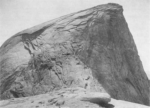
Postglacial and interglacial sculpturing of the cliffs has taken place by two different but somewhat allied processes: by prying out of roughly equant blocks bounded by joints (which are more numerous in some rocks than in others) and by spalling of huge curved sheets in joint-free rocks, thought to have resulted from expansion due to release of the weight of overlying rocks (Matthes, 1930, p. 114-117; Jahns, 1943). The most thoroughly jointed rocks of the valley are the diorite near its western end, and cliffs of this rock have disintegrated to form the massive talus aprons called the Rockslides, across from Wawona Tunnel. The least jointed rock is the quartz monzonite exposed in Half Dome and other domes overlooking the head of the valley, which are almost literally monolithic and whose tops were shaped by spalling. Sentinel Dome is the only one near the valley that consists of a different rock, namely the El Capitan granite. The domes achieved their rounded forms long before the advent of glaciation; they are not roches moutonees, for they were never overridden by ice.
The diorite of the Rockslides and the quartz monzonite are at opposite extremes in character of jointing. The valley walls between them consist of rocks that are intermediate in this respect, as has been pointed out in the paper by Calkins and Peck in this guidebook. The taluses, three of which are of great size, were probably formed mostly in postglacial time, by the breaking down of diorite and other closely jointed rocks that are now for the most part covered with talus. Those east of the Cathedral Rocks and east of El Capitan contain some glacial debris.
A sheeting that is flat rather than curved, induced apparently by wetting and drying or freezing and thawing, and controlled in part by joints, has led to the steepening of many of the cliffs of sparsely jointed rocks over which the waterfalls plunge, converting what may once have been foaming cascades to the free-plunging falls we see today. Most of the falls, particularly at their lower ends, are in recesses that could not have been carved by ice moving down the Merced River (note particularly Ribbon Fall and the base of Bridalveil Fall). The walls of these recesses are marked by closely spaced fractures which indicate that slabs of granite, parallel to the rock surface, have broken away from beneath the waterfalls. These fractures are particularly common near the lower ends of the falls. Talus cones, also, are piled beneath some of these falls, the debris of the fallen slabs. An example of this process, steepening a cascade to form a vertical waterfall, can be seen on the west side of Sentinel Rock.
|
| Photo 4. Northeast side of Half Dome, showing exfoliation on a gigantic scale. The arrow points to two men half way up the slope. In the foreground is an old shell disintegrating to granitic sand. Photo by F. C. Calkins, U.S. Geological Survey. |
References
Allen, V. T., 1929, The Ione formation of California: Univ. of California Dept. Geol. Sci. Bull., v. 18, pp. 347-448.
Axelrod, D. I., 1957, Late Tertiary floras and the Sierra Nevada uplift: Geol. Soc. America Bull., v. 68, pp. 19-46.
Bateman, P. C., 1956, Economic geology of the Bishop tungsten district, California: California Div. Mines Special Rept. 47, 87 pp.
Birman, J. H., 1957, Glacial geology of the upper San Joaquin drainage, Sierra Nevada, California: Univ. of California (Los Angeles), Ph. D. thesis, 237 p.
Blackwelder, Eliot, 1931, Pleistocene glaciation in the Sierra Nevada and Basin Ranges: Geol. Soc. America Bull., v. 42, pp. 865-922.
Creely, R. S., 1955, Geology of the Oroville quadrangle, California: Univ. of California (Berkeley), Ph. D. thesis.
Curtis, G. H., 1954, Mode of origin of pyroclastic debris in the Mehrten formation. of the Sierra Nevada: Univ. of California Pubs. Geol. Sci., v. 29, pp. 453-502.
Davis, S. N., and Hall, F. R., 1959, Water quality of eastern Stanislaus and northern Merced Counties, California: Stanford Univ. Pubs. Geol. Sci., v. 6, pp. 1-112.
Evernden, J. F., Curtis, G. H., and Kistler, Ronald, 1957, Potassium-argon dating of Pleistocene volcanics: Quaternaria, v. 4, pp. 1-5.
Gilbert, C. M., 1938, Welded tuff in eastern California: Geol. Soc. America Bull., v. 49, pp. 1829-1862.
Gutenberg, Beno, Buwalda, J. P., and Sharp, R. P., 1956, Seismic explorations on the floor of Yosemite Valley, California: Geol. Soc. America Bull., v. 67, pp. 1051-1078.
Hack, J. T., 1957, Studies of longitudinal stream profiles in Virginia and Maryland: U.S. Geol. Survey Prof. Paper 294-B, pp. 45-97.
Hoots, H. W., Bear, T. L., and Kleinpell, W. D., 1954, Geological summary of the San Joaquin Valley, California, in Chap. 2 of Jahns, R. H., ed., Geology of Southern California: California Div. Mines Bull. 170, Chap. 2, pp. 113-129.
Hudson, F. S. 1955, Measurement of the deformation of the Sierra Nevada, California, since middle Eocene: Geol. Soc. America Bull., v. 66, pp. 835-870.
Hudson, F. S., 1960, Post-Pliocene uplift of the Sierra Nevada, California: Geol. Soc. America Bull., v. 71, pp. 1547-1575.
Jahns, R. H., 1943, Sheer structure in granites, its origin and use as a measure of glacial erosion in New England: Jour. Geology, v. 51, pp. 71-98.
Jenkins, O. P., 1932, Report accompanying geologic map of northern Sierra Nevada: California Div. Mines Rept. 28, pp. 279-298, and geologic map.
Leopold, L. B., and Maddock, Thomas, Jr., 1953, The hydraulic geometry of stream channels and some physiographic implications: U.S. Geol. Survey Prof. Paper 252, 57 pp.
Leopold, L. B., and Wolman, M. G., 1957, River channel patterns—braided, meandering, and straight: U.S. Geol. Survey Prof. Paper 282—B, pp. 39-85.
Lindgren, Waldemar, 1900, Description of the Colfax quadrangle, Colfax, California: U.S. Geol. Survey Geol. Atlas, Folio 66.
Lindgren, Waldemar, 1911, The Tertiary gravels of the Sierra Nevada of California: U.S. Geol. Survey Prof. Paper 73, 226 pp.
Lindgren, Waldemar, and Turner, H. W., 1894, Description of the gold belt, in Description of the Placerville quadrangle [California]: U.S. Geol. Survey Geol. Atlas, Folio 3.
Matthes, F. E., 1930, Geologic history of the Yosemite Valley: U.S. Geol. Survey Prof. Paper 160, 137 pp.
Matthes, F. E., 1942, Glaciers, in Meinzer, O. E., ed., Physics of the earth, Pt. 9, Hydrology: New York, McGraw Hill Book Co., pp. 149-219.
Piper, A. M., Gale, H. S., Thomas, H. E., and Robinson, T. W., Jr., 1939, Geology and ground-water hydrology of the Mokelumne area, California: U.S. Geol. Survey Water-Supply Paper 780, 230 pp.
Rinehart, C. D., and Ross, D. C., 1957, Geology of the Casa Diablo Mountain quadrangle, California: U. S. Geol. Survey Geol. Quad. Map GQ-99.
Rinehart, C. D., in press, Geology and mineral deposits of Mt. Morrison quadrangle, California: U.S. Geol. Survey Prof. Paper 385.
Turner, H. W., 1894, Description of the Jackson quadrangle [Sierra Nevada, California]: U.S. Geol. Survey Geol. Atlas, Folio 11, 6 p.
Turner, H. W., and Ransome, F. L., 1897, Description of the Sonora quadrangle [California]: U.S. Geol. Survey Geol. Atlas, Folio 41, 5 p.
Turner, H. W., 1898, Description of the Big Trees quadrangle [California]: U.S. Geol. Survey Geol. Atlas, Folio 51, 8 p.
| <<< Previous | <<< Contents >>> | Next >>> |
state/ca/cdmg-bul-182/sec4.htm
Last Updated: 03-Aug-2009
