
|
California Division of Mines and Geology
Self-Guided Geologic Tour in Joshua Tree National Monument |
GEOLOGY TOUR ROAD LOG
Monument naturalists designed an 18 mile self-guided motor trail tour along a dirt road that winds through the most interesting geology in the Monument. The Geology Tour Road has 16 signposts where vehicles can pull over and stop (Figure 2). The tour, along with its accompanying brochure, Geology And Man (Wanrow, 1975), provide a step-by-step guide about geologic processes that shaped the desert landscape we see today. The following Geology Tour Road log explains the formation of a fault scarp and a dry lake bed, how granite weathers in the desert, and how sand dunes and alluvial fans form.
Although the dirt road is readily accessible by car, you may prefer to ride a dirt bike. It takes about two hours to complete the tour by car. Park rangers advise bringing drinking water. They also recommend that you end the tour at Stop 9 when the road becomes wet during the rainy season.
The numbered stops at the beginning of each description correspond to numbered markers along the tour route. Mileage starts at the intersection of the Geology Tour Road and the black-topped main Monument road. The tour route is a closed loop that returns you to the starting point.
ROAD LOG
| Mileage | Cumulative Mileage |
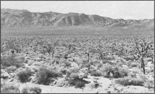
0.4 0.4 Stop 1. WHY A VALLEY? Queen Valley (elevation 4,400 feet) is one of two types of valleys along the tour (Photo 4). This and Lost Horse Valley to the west were formed by a different rate of erosion between the softer rock underlying the valleys and the more resistant rock of the surrounding mountains. Because the rock beneath these valleys is less resistant to erosion than the rock forming the surrounding mountains, it disintegrates sooner and forms the low-lying plain you see at this stop.
The other type of valley, Pleasant Valley, (seen later on the tour), is the result of fault movement that produced uplift to the north and subsidence to the south.
0.8 1.2 Stop 2. A RAINBOW DIVIDES. This knoll is the north-south drainage divide for the Monument. Water drains from this point either to the northwest via Quail Springs Wash, or to the southeast via Fried Liver Wash into Pinto Basin. The erosive force of running water plays an important part in shaping the desert landscape.
1.7 2.9 Stop 3. NATURE'S GUTTER. Here, runoff water accumulates to form a wash. During the summer months, intense rainstorms often produce flash floods along many desert washes. Weathering processes physically and chemically break down rocks into smaller and smaller pieces, and eventually form soil. The loosened material is carried to lower elevations by water and deposited. These deposits, called alluvial fans, will be seen later in the tour.
The increased soil moisture along these washes allows certain plants, such as the California juniper, to grow more vigorously here than in the drier surrounding desert.
0.3 3.2 Stop 4. OLD EROSIONAL LEVEL. Many of the quartz monzonite boulders to the east of the road bear a distinct groove or band about seven feet above ground level. This groove indicates an old erosional level when the soil surface remained at a static level for an extended period of time. Weathered sand grains from the granitic rock wind-blasted the rock and formed the groove. Subsequent erosion lowered the soil level. This example illustrates how changes in climate produce corresponding changes in the landscape.
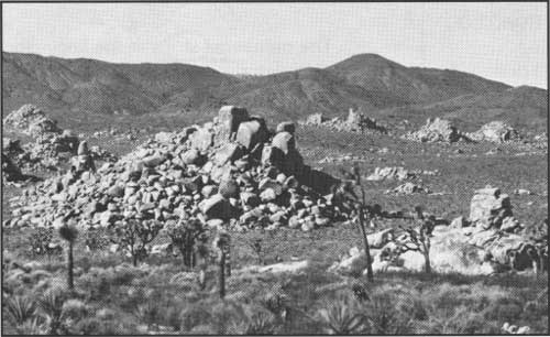
0.5 3.7 Stop 5. ROCK PILES. White Tank monzonite forms the rock piles on both sides of the road (Photo 6). This rock was once a deeply buried molten mass called magma that forced its way upward into the overlying much older Pinto Gneiss. The magma cooled without reaching the surface and crystallized to form a solid rock mass—the White Tank monzonite. Erosion over geologic time stripped away the darker Pinto Gneiss exposing the monzonite outcrops.
|
| Photo 6. White Tank monzonite rock piles to the west of the Tour Road at Stop 5. |
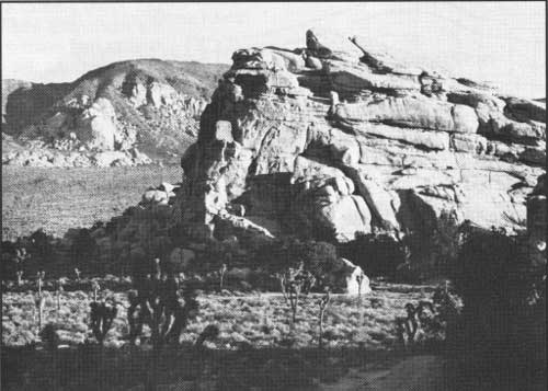
The mountains to the west are composed primarily of gneiss. Ryan Mountain (5,461 feet) displays the contact between these two different rock types (Photo 7). Harder, more resistant areas within the monzonite form the numerous rock piles. Many of these have well defined joint systems (Photo 7), while other eroded White Tank monzonite rock masses have collapsed into jumbled piles (Photo 6).
|
| Photo 7. Eastward view across Lost Horse Valley toward the Lost Horse Mountains (Figure 2). Ryan Mountain, in the left background, illustrates how the light White Tank monzonite has intruded upward into the much older Pinto Gneiss. Note how the exposed and more resistant monzonite at Ryan Mountain is capped by the much darker gneiss directly above it. Photo courtesy of the National Park Service. |
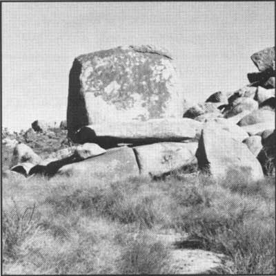
0.6 4.3 Stop 6. ROCK SCULPTURE. After the White Tank monzonite solidified, it was fractured by regional geologic forces into joints. These joints usually occur in two sets and intersect at nearly right angles. These joint planes acted as zones of weakness and, over geologic time, erosive agents readily attacked the monzonite along these joints. The result is boulders which are roughly rectangular in shape. A massive rectangular boulder to the east of the road illustrates this type of erosion (Photo 8). Many of these boulders weather into grotesque shapes and have been given such descriptive names as the "Skull" (found near Jumbo Rocks) and the "Trojan" and "The Ox" (found along the Hidden Valley Nature Trail).
|
| Photo 8. Massive rectangular monzonite boulder (in center of photo) just to the east of Stop 6 is about 13 feet high. |
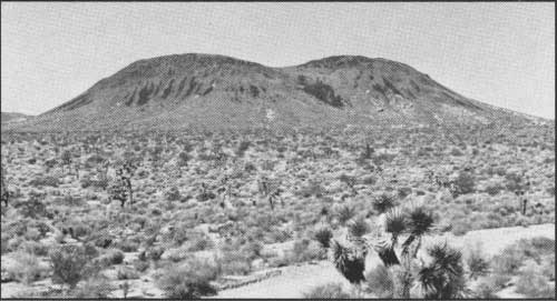
0.5 4.8 Stop 7. MALAPAI HILL. Three-quarters of a mile west of this point the twin peaks of Malapai Hill rise about 400 feet above the valley floor (Photo 9). The hill is composed of black basalt and resulted from a shallow injection of basaltic magma which did not quite reach the surface of the Earth. If it had reached the surface, a lava flow or volcano would have resulted, but there is no evidence of such a flow. The Malapai Hill basalt intruded the White Tank monzonite and is therefore younger. Although its true age is unknown, it appears likely that it was emplaced during the last two or three million years. In comparison to the Pinto Gneiss, which is about 1.5 billion years old, the Malapai Hill basalt is a geologically recent rock unit.
|
| Photo 9. Malapai Hill 3/4 mile due west of Stop 7. This mound is composed of dark basalt and formed as a molten mass of magma that intruded through the surrounding White Tank monzonite, however, it did not reach the surface. Extensive erosion over geologic time has weathered away the less resistant White Tank monzonite. |
From this stop a 3/4 mile nature trail to the base of Malapai Hill offers you an opportunity to inspect a basaltic intrusion up close. The nature trail walk takes about 45 minutes to complete. A balanced rock occurs along the nature trail about 1/4 mile west.
0.4 5.2 Stop 8. ALLUVIAL FANS. You are now descending an alluvial fan (Photo 10). Notice a similar fan extending from the mountains into the valley to the south. These fans are composed of sands, gravels, cobbles, and boulders produced from the erosion of rocks at higher elevations. This rock material is carried by gravity and flood waters to lower levels. When flood waters reach the alluvial fans, the larger, heavier rocks drop first and the lighter gravels and sands are carried farther out into the valley before they settle. Alluvial fans illustrate the constant changes in the desert landscape. Mountains are constantly being eroded by geologic processes as the eroded material is deposited in the alluvial fans.
|
| Photo 10. View west across an alluvial fan toward Lost Horse Mountains at Stop 8. |
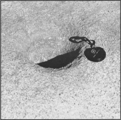
0.4 5.6 Stop 9. SQUAW TANK. Archaeological investigations reveal that nomadic Indians inhabited this area from about 1000 A.D. until the early 1900s. Squaw Tank was a favorite campsite because of the natural water catch-basin. Bowl-like mortars were hollowed into the quartz monzonite and were used to grind seeds and other bits of food into meal. Several of these bedrock mortars can be seen just south of the large rock in front of you (Photo 11).
|
| Photo 11. Indian mortar hole drilled into the White Tank monzonite at Stop 9. Two-inch lens cap for scale. |
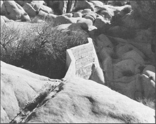
A concrete dam just to the southeast, and hidden in the wash, forms Squaw Tank (Photo 12). Cattlemen built this and other similar dams to catch runoff water for their cattle during the early 1900s. Many of these small catchment dams are located where natural pools of water collected after rains. It was in such places that the Indians also obtained water and it is logical to assume that they camped at this spot because of the natural catch-basin.
|
| Photo 12. Concrete dam at Stop 9. Center of dam is about 9 feet high. |
DIKES. Notice the light-colored bands of rock cutting across many of the monzonite boulders in this area. These bands, called dikes, were formed when molten rock of a different texture intruded into joints in the already-formed monzonite. Many of these dikes are composed of a light-colored, fine-grained rock called aplite. It is much harder and more resistant to erosion than the monzonite, and stands out in relief when the monzonite erodes. An excellent dike that forms a wall can be found to the east of the road a short distance beyond this stop.
STOP HERE IN WET WEATHER AND RETURN TO THE MAIN BLACK TOP ROAD.
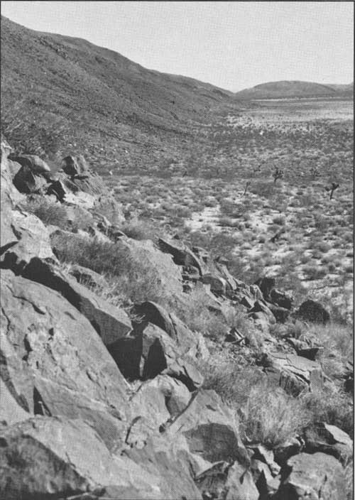
0.2 5.8 Stop 10. PLEASANT VALLEY. As you rounded the bend and viewed the expanse of Pleasant Valley in front and to the right, did you notice the steep mountain face to your left? This steep east-to-west trending mountain escarpment is a fault scarp and was formed by movement along the Eagle Mountain fault (Photo 13). A little farther to the east this fault combines with the much larger Blue Cut fault, also a east-west trending fault, which has a 50-mile trace stretching from the western foot of the Little San Bernardino Mountains to the eastern edge of the Pinto Basin. The Eagle Mountain fault scarp is part of a fracture zone that varies from 300 to 1,000 feet in width and follows the base of the mountain before you (Photo 13). North of the fault, the Pinto Gneiss was lifted up relative to the landscape on the south. Geologists call this type of fault a "normal" fault. The combination of up-lift and down-drop created Pleasant Valley, the second type of valley that you have seen (the first was Queen Valley, a result of differential erosion between rock types).
|
| Photo 13. View toward the southeast along the Eagle Mountain fault zone that runs along the base of the mountains where they meet the desert floor at Stop 10. |
The Blue Cut fault is named for the granodiorite (a combination of granite and diorite minerals) that has a "bluish" tinged color possibly caused by stressed quartz or stressed feldspar that occurred along the fault zone. The Blue Cut fault scarp and its associated bluish granodiorite is exposed on the mountainside directly to the west and across Pleasant Valley.
PETROGLYPHS. Petroglyphs or Indian rock carvings can be seen about 150 feet to the north of this stop (Photo 14). This ancient art is found on rocks coated with thin "desert varnish," a dark chemical deposit which forms on desert rocks over time. Indians chipped this varnish layer away to expose the much lighter rock beneath. These carvings may have had some religious meaning to the Indians, but this is only conjecture. Some petroglyphs in the Monument may be thousands of years old; desert varnish has reformed on some carvings—a weathering process that takes considerable time. Please help protect this prehistoric Indian art.
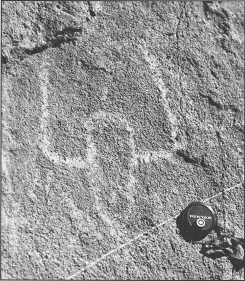
|
| Photo 14. Indian petroglyph carved into desert varnish. |
1.0 6.8 Stop 11. DRY LAKE. This dry lake, also called a desert playa, that you are now crossing is evidence that a wetter climate existed here. A periodic lake once filled Pleasant Valley and lacustrine (lake) sediments were deposited in this lake to a depth of hundreds of feet. As the lake evaporated, salts crystallized and precipitated out of the water. Several similar playa lake beds in other parts of the California desert are mined commercially for a variety of salts, such as borax.
SAND DUNES. To the left, notice the sand deposits and the start of sand dune formation. This is typical of areas where there is a source of sand (the playa), and an open flat area (Pleasant Valley) where wind picks up sand particles and carries them to the mountain front, which acts as a barrier causing the sand and silt to fall at the mountain base and form sand dunes.
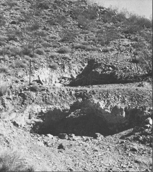
0.4 7.2 Stop 12. MINES. The mountain slopes in front and to the north are honeycombed with tunnels and shafts dug by miners looking for gold and other precious metals (Photo 15). There was extensive mining activity throughout this area during the late 1800s and early 1900s. Very few of the mines, however, proved lucrative; the Lost Horse mine in the Lost Horse Mountains (Figure 2) is one exception. Gold, silver, copper, lead, and other metals of economic importance were deposited when the intruding White Tank monzonite magma cooled and crystallized. Various gasses and liquid solutions carrying these dissolved metals migrated upward from the invading magma through the surrounding older rock. As these fluids cooled, the metals precipitated out and were deposited along pre-existing fractures or fissures to form ore veins. Quartz is often associated with these veins and is used as an indicator for possible ore deposits.
|
| Photo 15. Mine shafts at Stop 12. Abandoned mine shafts and adits are dangerous and should be avoided; note the barbed-wire posts surrounding the shaft. |
1.9 9.1 Stop 13. CATTLE RANCHING. Here, along the base of the alluvial fan, the soils are deeper and more runoff water accumulates. The added moisture allows for more vigorous plant growth such as grasses. In the late 1870s, ranchers introduced Texas longhorns to this area because of the lush vegetation. Over-grazing and a long drought after 1932 led to the decline of cattle ranching. The numerous cholla cacti in this area indicate this rangeland was overgrazed. Grasses died from lack of nutrients and were replaced by cactus. With the establishment of the Monument in 1936, cattle grazing was eliminated, allowing the range to partially restore itself.
0.8 9.9 Stop 14. PINTO GNEISS. The banded and folded rock to your left, the oldest type of rock in the Monument, is Pinto Gneiss. Although its absolute age is not known, it is thought to be about 1.5 billion years old (Photo 5). Whereas the basalt of Malapai Hill and the quartz monzonite are igneous rocks—the product of a cooled magma—gneiss is the product of metamorphism. Metamorphism with its intense pressure and/or heat causes physical changes to occur in rock. The Pinto Gneiss was originally sediments that were laid down in ancient lakes or seas, and have undergone extensive alteration due to the pressure of overlying material and heat caused by invading magmas. This change resulted in the realignment of the chemical constituents of the former rock to produce a completely different rock.
LICHENS. The bright splotches of color found on many of the rocks are primitive forms of plant life called lichens. The different colors indicate different species. Some form a weak carbonic acid that chemically breaks down rock to form soil. These tiny plants form a very important part of the erosional cycle.
0.0 9.9 Stop 15. PINYON WELL JUNCTION. The dirt road to the left leading into the canyon is a dead end road and not part of the Geology Tour Road. A well in this canyon provided water that was used for processing of gold ore and for cattle. The well is now dry.
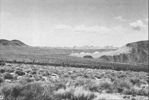
0.1 10.0 Stop 16. PANORAMIC VIEW. Aside from being an outstanding picture point, this stop affords you the opportunity to review at one glance many of the geologic processes seen along the tour (Photo 16). Geology is the study of the history of the Earth and is manifested by constant changes in the landscape. These changes involve the building of mountains, their destruction, and subsequent rebuilding. We see evidence of mountain building in the mountain range formed along the Blue Cut fault north of Pleasant Valley. We see mountains formed by the igneous intrusions at Malapai Hill and the White Tank monzonite. And finally, we see geologic processes eroding these mountains and depositing the eroded material onto the desert floor to produce playas, alluvial fans, and sand dunes.
|
| Photo 16. View to the north across Pleasant Valley from Stop 16. Malapai Hill is to the left, the Hexie Mountains and the Eagle Mountain fault zone at its base are to the right. The White Tank monzonite is in the distance and the Geology Road can just be seen as a light wavy band in the middle. |
To return, continue 2.2 miles to Squaw Tank and from there 5.5 miles to the main Monument road in Queen Valley. As you approach the Squaw Tank area, notice the mountains to the east which have an excellent contact of dark Pinto Gneiss in contrast with the adjacent much lighter White Tank monzonite.
| <<< Previous | <<< Contents >>> | Next >>> |
ca/cdmg-cg-44-9/sec2.htm
Last Updated: 15-Sep-2011