|
California Division of Mines and Geology
Special Report 106 Geologic Features—Death Valley, California |
Geology of the Grapevine Mountains, Death Valley, California: A Summary
Mitchell W. Reynolds1
111780 Swadley Drive, Lakewood, Colorado 80215.
INTRODUCTION
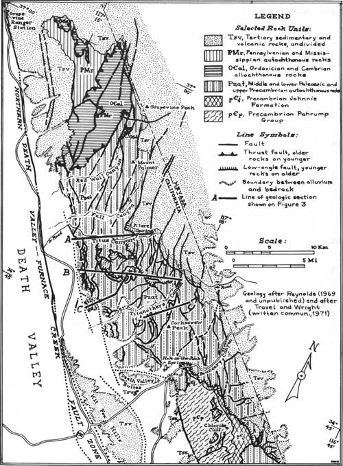
The Grapevine Mountains, limited on the south by Boundary Canyon and on the north by Grapevine Canyon, form the eastern wall of northern Death Valley (Fig. 1). The mountains are rugged and have poor accessibility, but their high relief and barrenness provide excellent exposures of the complicated geology characteristic of the Death Valley region. Upper Precambrian and Paleozoic rocks exposed in the core of the mountains are the most northerly complete section of miogeosynclinal facies strata on the east side of the northern Death Valley—Furnace Creek fault zone. In the core of the mountains, a thrust fault of early or medial Mesozoic age juxtaposes upper Precambrian, Cambrian, and Ordovician rocks over middle and upper Paleozoic strata. Cenozoic rocks flank the core and include both the oldest dated Tertiary strata in the southwestern part of the Great Basin and an extensive succession of younger sedimentary and volcanic rocks. These and older strata are broken by late Cenozoic high-angle normal faults that flatten with depth east and west off the core of the range. In the southern part of the mountain core, folding and faulting of late Tertiary age produced a north-trending S-shaped fold system composed of a recumbent syncline and anticline. A low-angle fault, along which rocks are rotated and extended, replaces the upright limb of the anticline, and the entire fold system is separated from underlying metamorphosed Precambrian rocks by a low-angle fault that also displaces Tertiary strata at shallow depths. Strike-slip faults of late Cenozoic age displace rocks and structures in the range, as well as Quaternary deposits in adjacent Death Valley.
In this summary of the geology of the Grapevine Mountains, emphasis is on the southern part of the mountains, since this area is accessible by road through Boundary and Titus Canyons. The geology of the Grapevine Mountains has been mapped largely by me; mapping by Cornwall and Kleinhampl (1964) in the southeasternmost part of the mountains and by L. A. Wright and B. W. Troxel (1971, written commun.) along the southern edge has provided a base for more detailed mapping and structural interpretations of those parts by me.

|
| Low altitude oblique aerial photograph across Death Valley northeast of Grapevine Mountains between mouth of Titus Canyon (left) and Titanothere Canyon (right). Pale rocks just below skyline are Tertiary rocks, mostly volcanic. Stratified rocks in Grapevine Mountains range in age from early Cambrian (right) to late Paleozoic (left) and are highly deformed. See article that follows. Photo W16 by John H. Maxson; courtesy of the National Park Service. |
STRATIGRAPHY
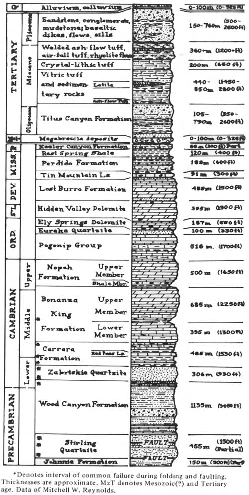
Nearly 9,100 m (30,000 ft) of pre-Mesozoic and Cenozoic sedimentary and volcanic rocks are exposed in the Grapevine Mountains (Fig. 2). For about 9.6 km (6 mi) southeast of Boundary Canyon to Chloride Cliff, the oldest rocks crop out in the anticlinal core of the Funeral Mountains (Wright and Troxel, 1970; 1971, written commun.). These rocks belong to the Pahrump Group of Precambrian age. Northwestward, a nearly continuous succession of pre-Mesozoic rocks is preserved down structural plunge from Chloride Cliff to the north end of the Grapevine Mountains, where strata of Pennsylvanian age crop out. The lowest quarter of the succession, widely exposed in Boundary Canyon, is a thick sequence of terrigenous clastic rocks, whereas much of the remainder of the section is composed of carbonate rock with only thin, interbedded terrigenous units. Some of the Precambrian, Cambrian, and Mississippian rocks may have accumulated in moderately deep marine waters, but the carbonate and terrigenous rocks were generally deposited in shallow-marine and intertidal environments on a slowly subsiding shelf. Siltstone, sandstone, and conglomerate beds among upper Paleozoic rocks were derived from uplands presumably to the northwest and north resulting from the Antler orogeny.
Terrigenous strata in the pre-Mesozoic sequence have generally been the loci of failure during deformation. Preferred units of failure are designated by asterisks in Figure 2. The Stirling and Zabriskie Quartzites, for example, controlled positions of faulting during both Mesozoic and Cenozoic deformation: these formations form the sole of the allochthon of the major thrust fault of Mesozoic age in the northern part of the Grapevine Mountains, and form the soles of flat faults of Cenozoic age in Boundary Canyon. Recumbent folding, probably late Tertiary in age, in the southern Grapevine Mountains involved rocks only as old as the Stirling Quartzite, which acted as a sole for detachment above metamorphosed and deformed older rocks. High-angle faults of Cenozoic age are commonly flattened with depth to follow siltstone and quartzite beds in Paleozoic strata.
Cenozoic rocks crop out widely along the east flank and the northwest front of the Grapevine Mountains and locally near Death Valley Buttes, west of the mouth of Boundary Canyon. Rocks on the northwest front differ in origin and age from those on the east and south. At the latter localities, strata of fluvial and lacustrine origin belonging to the Titus Canyon Formation of Oligocene and Miocene(?) age (Reynolds, 1969, 1974) rest unconformably on Paleozoic rocks and are, in turn, overlain unconformably by ash-flow tuff, lava flows, and sedimentary rocks of lacustrine and fluvial origin. This succession of volcanic and sedimentary rocks is about 22 to 20 m.y. old, and sources for most of the volcanic rocks lay within the Nevada Test Site east and northeast of the Grapevine Mountains.
Cenozoic rocks are exposed along the mountain front in the northern part of the Grapevine Mountains northwest of Fall Canyon and at the southern end of the mountains in the Kit Fox Hills (Fig. 1). Rocks northwest of Fall Canyon are divided into three parts—the lowest exposed part and the upper part are dominantly of fluvial origin, and rocks of the middle part are of lacustrine origin. The lower fluvial and lacustrine rocks are conformable, but the upper fluvial sequence lies unconformably on the lacustrine rocks. Thin, coarse basaltic intrusions occur in the lowest two units. Clasts in the lower fluvial sequence were derived from granitic intrusive rocks exposed at the north end and west of Death Valley; clasts of welded ash-flow tuff were eroded from units northeast and east in the Grapevine Mountains and beyond, but clasts of locally derived pre-Mesozoic rocks are not abundant. By contrast, the upper fluvial rocks are composed mainly of fragments eroded from pre-Mesozoic rocks in the Grapevine Mountains, onto which the fluvial strata lap or are faulted. The lower two units are here correlated with the Furnace Creek Formation as defined by McAllister (1970) and the upper unit with the Funeral Formation, both in the central part of Death Valley. Cenozoic lacustrine and fluvial rocks of the Kit Fox Hills west of Death Valley Buttes (Fig. 1) contain clasts derived from ash-flow tuff units of Miocene and early Pliocene age exposed east of Death Valley (Fig. 2), and hence are considered to be of middle or late Pliocene age, equivalent to the Furnace Creek Formation (compare with Hunt and Mabey, 1966, p. A57).
|
| Figure 2. Generalized columnar section of rocks exposed in the Grapevine Mountains, Death Valley, California. |
Alluvium eroded from the mountains spreads into Death Valley from major canyons and rills. Hunt and Mabey (1966) and Reynolds (1969) recognized four ages of alluvium northward from Boundary Canyon. The alluvium is both faulted against the mountain front from Titanothere to Red Wall Canyon (Fig. 1) and banked depositionally against several fault scarps, demonstrating intermittent movement along different segments of the mountain front. Alluvium adjacent to the mountains is unfaulted south of Titanothere Canyon to beyond Boundary Canyon, although locally warped. Clay, silt, and evaporite minerals are accumulating on a playa adjacent to the steep front of the Grapevine Mountains between Titus and Titanothere Canyons. The eastward displacement of the playa with respect to the axis of Death Valley toward the frontal scarp of the mountains suggests that that segment of the valley is tilting downward to the east. Both alluvium and playa sediments are displaced by faults along the northern Death Valley—Furnace Creek fault zone.
The general geologic structure of the Funeral and Grapevine Mountains is a broad anticlinorium with the deepest structural level exposed in the culmination near Chloride Cliff in the northern part of the Funeral Mountains. Progressively shallower structural levels are exposed northward across the Grapevine Mountains and southeastward across the southern part of the Funeral Mountains. Shallower structural levels are also exposed down the dip of the east flanks of the mountains and locally on the west flanks. The exposed structures developed during two principal times of deformation: the older during early Mesozoic time (probably Late Triassic or Early Jurassic [Burchfiel and others, 1970]), and the younger encompassing middle and late Cenozoic time. Different styles of deformation characterized by thrust faulting in which upper Precambrian and lower Paleozoic rocks were thrust over middle and upper Paleozoic rocks. The later deformation, however, is primarily distinguished by normal faulting and doming associated with regional tectonic extension and igneous activity. The following summary describes structures of early Mesozoic age and emphasizes structures of Cenozoic age.
Structures of Mesozoic Age. Across the northern part of the Grapevine Mountains, rocks of Precambrian, Cambrian, and Ordovician age are thrust over rocks ranging in age from Ordovician into Pennsylvanian. The fault is called the Grapevine thrust fault (Reynolds, 1971). At the base of the allochthonous plate about 8 km (5 mi) west-northwest of Mount Palmer, strongly contorted beds of the Stirling Quartzite are tectonically interleaved with deformed beds of the Wood Canyon Formation. There these rocks rest on the autochthonous Perdido Formation and Rest Spring Shale of Mississippian and Pennsylvanian(?) age. North and west-southwest of Mount Palmer, the Wood Canyon Formation is the lowest exposed unit of the allochthon. Rocks of the upper plate generally dip north across the north end of the Grapevine Mountains, so that the Cambrian Zabriskie Quartzite, Carrara, Bonanza King, and Nopah Formations, and the Ordovician Pogonip Group successively form the sole of the upper plate. Rocks of the upper plate are folded in a tight north-trending anticline 3.2 km (2 mi) southwest of Grapevine Peak, in the core of which the Wood Canyon Formation is exposed, but otherwise the plate was not strongly deformed during thrusting.
The authochthon includes the entire succession of Paleozoic and Precambrian rocks exposed from outcrops of the Grapevine thrust fault southward up the regional plunge to the major culmination of the anticlinorium near Chloride Cliff. Immediately beneath the fault, middle and upper Paleozoic rocks are strongly deformed: 9.7 km (6 mi) west of Grapevine Peak, the Mississippian Perdido Formation, the Rest Spring Shale, and the Pennsylvanian Keeler Canyon Formation are locally overturned west or northwest beneath the fault. This overturning suggests that the allochthon moved southeast and east. West of Mount Palmer the Devonian Lost Burro Formation is locally contorted in disharmonic folds beneath the thrust fault. Farther south the autochthon seems to have been little deformed during thrusting.
Stewart and others (1966) suggested that the Grapevine thrust fault may be equivalent to the Last Chance thrust fault that they described from extensive exposures west of Death Valley. The Last Chance thrust fault is structurally the highest and youngest thrust fault and seems to have the greatest displacement in a succession of thrust faults west of Death Valley, including the Lemoigne, Gap Hills, Big Horn, Quartz Springs, and Racetrack thrust faults (McAllister, 1952; Hall and Stephens, 1962). I (1971) tentatively accepted the correlation of the Last Chance and Grapevine thrust faults and noted that the Grapevine thrust fault continues east from the Grapevine Mountains through exposures in the Bullfrog Hills to Bare Mountain, where Cornwall and Kleinhampl (1961) described a thrust fault at Meiklejohn Peak, which shows similar structural and stratigraphic relations. Although the specific surface of thrusting is not likely the same across the region, the exposed fault surfaces are probably part of the Last Chance thrust system. Thrust faults equivalent to the older described faults on the west side of Death Valley do not seem to be present on the east side in either the Grapevine Mountains or the northern part of the Funeral Mountains. Plutons of quartz monzonite that intrude the thrust faults west of Death Valley have approximate radiometric ages of 156 and 165 m.y., and Burchfiel and others (1970) consider that thrusting occurred during latest Paleozoic and early Mesozoic time, most likely during Middle Triassic to Early Jurassic time. That age of thrusting is also accepted for the Grapevine thrust fault.
No stratigraphic record of tectonic events younger than thrusting but older than Oligocene age is preserved in the Grapevine Mountains. Deformed Precambrian and Paleozoic rocks were tilted northward prior to erosion of the surface on which rocks of the Titus Canyon Formation (Oligocene and Miocene(?)) accumulated. That formation rests on Precambrian-Cambrian Wood Canyon Formation east of Chloride Cliff (L. A. Wright and B. W. Troxel, 1971, written commun.) and on progressively younger strata to the north where, near Grapevine Peak, it rests unconformably on allochthonous rocks of the Grapevine thrust fault. The relation suggests that the area of the Funeral Mountains was a structural high prior to the erosion and that the present anticlinorium represents a middle and late Cenozoic rejuvenation of that earlier structure.
Structures of Cenozoic Age. The most conspicuous geologic structures in the Grapevine Mountains and northern Funeral Mountains developed during Cenozoic time. Deformation was episodic in pulses between 20 and 16, ~14 and 13, and 11 and 7 m.y., and has been nearly continuous since (Reynolds, 1974). The first two episodes were characterized by uplift in the southern part of the area and by faulting along northeast and north trends. The episode between 11 and 7 m. y seems to have been particularly intense, for, during that time, doming, recumbent folding, and extensive faulting along a north trend occurred. Intermittent younger deformation has produced much of the relief evident along the mountain fronts and right-lateral faulting that displaces Quaternary units in northern Death Valley.
In section view from north-northwest to south-southeast along the Grapevine Mountains and northern Funeral Mountains, the general structure that developed during Cenozoic time is an anticlinorium with a major culmination in the vicinity of Chloride Cliff and a second culmination between Mount Palmer and Grapevine Peak (Fig. 1). From east to west the ranges are anticlinal with tilted, faulted Tertiary rocks on the east and west flanks. Minimum structural relief between the culmination at Chloride Cliff and the northern end of the Grapevine Mountains is 10.6 km (6.6 mi). Southeast down plunge from Chloride Cliff the apparent structural relief exceeds 6 km (3.7 mi). Structural relief between the crest of the second culmination near Mount Palmer and the equivalent stratigraphic horizon in the adjacent depression that lies between Titus and Titanothere Canyons is about 3 km (1.9 mi). Part of the relief had developed prior to Oligocene time, but most developed in Pliocene time, as demonstrated by strata of early Pliocene age tilted to angles of 45° on the flanks of the folds.
About 8 km (5 mi) east-southeast of Chloride Cliff, high-angle faults that displace rocks as young as Pliocene flatten westward and northward with depth, merging to form a single low-angle fault (L.A. Wright and B. W. Troxel, 1971, written commun.). Progressively north along the east flank of the range, north-trending faults also flatten with depth to join the master low-angle fault. In its southernmost exposures that fault is within the Stirling Quartzite, but from about 5 km (3 mi) east of Chloride Cliff to Boundary Canyon the fault forms a surface of decollement between the Precambrian Johnnie Formation below and the Stirling Quartzite and younger strata above. Across that area, Tertiary, Cambrian, and Precambrian strata, in blocks bounded by the high-angle faults that flatten to join the master fault, are rotated downward to the east or northeast to angles as steep as 75°. The low-angle master fault is well exposed between the Stirling Quartzite and Johnnie Formation on the north side of Boundary Canyon from south of Hole-in-the-Rock Spring east for about 1 km (0.7 mi).
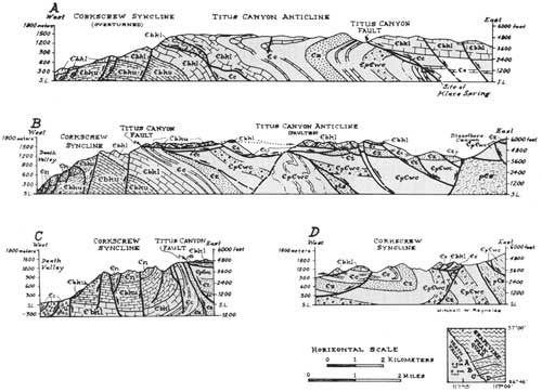
From Boundary Canyon north as far as Titus Canyon in the Grapevine Mountains, the Stirling Quartzite, Wood Canyon Formation, and Cambrian beds are folded in an S-shaped fold system that consists of a recumbent syncline on the west and a structurally higher upright-to-recumbent anticline on the east (Fig. 3). The low-angle fault visible beneath the Stirling in Boundary Canyon is the surface of decollement between the recumbently folded strata and metamorphosed deformed older rocks. A limestone unit in the lower part of the Carrara Formation outlines the tight core of the recumbent syncline on Corkscrew Peak, and the Stirling and Wood Canyon beds east for 2km (1.3 mi) from Hold-in-the-Rock Spring outline the broader, lower part of the syncline. The anticline is defined by outwardly opposing dips in the Wood Canyon Formation exposed on the northwest side of the highway through Boundary Canyon about 6.5 km (4 mi) above the spring. In Boundary Canyon, the anticline is faulted downward approximately 1.6 km (1 mi) against the overturned east limb of the syncline.
Traces of the fold axes trend about N. 60° W. toward a salient in the S-shaped fold system near Titus Canyon; north of the salient they trend north. The folds plunge northwest off the culmination of the Funeral Mountains anticlinorium. The trace of the axial surface is exposed in progressively younger beds northwest from Boundary Canyon in the recumbent syncline. so that between Titanothere and Titus Canyons the Upper Cambrian Nopah Formation forms the core of the fold (B and C in Fig. 3). Beds of the Cambrian Bonanza King Formation are the youngest exposed on the upright limb of the anticline near Titus Canyon, but farther north progressively younger Paleozoic rocks are continuous above the Bonanza King. Otherwise, only older strata are exposed in the anticline, and generally the overturned limb on the west has been faulted out. The axial surface of the syncline dips 20° to 60° to the east; for about 5 km (3 mi) southeast from the mouth of Titus Canyon, the recumbent syncline has been rotated downward toward Death Valley so that the axial surface dips about 15° to the west (A and B in Fig. 3). At Boundary Canyon the axial surface of the anticline is nearly vertical, but it dips northeast at progressively lower angles toward Titanothere Canyon. The recumbent part of the anticline is fully preserved only north of Titus Canyon where the axial surface dips from 5° to 10° to the east (A in Fig. 3).
Between Titus and Titanothere Canyons, where the west-directed salient of the fold system coincides with the structural depression in the range, beds of the upright limb of the anticline are broken by numerous normal faults (B in Fig. 3). Along these faults the strata have been rotated downward to the west and effectively extended over a wider area. The faults flatten eastward to join a single, nearly flat fault called the Titus Canyon fault; it separates the upright but faulted beds from the overturned limb of the recumbent syncline beneath (Fig. 1; B in Fig. 3). That low-angle fault replaces the axial surface of the anticline south of Titus Canyon, whereas north from Klare Spring in the canyon, the fault steepens to become nearly vertical and parallel to the trace of the upper part of Fall Canyon (Fig. 1; A in Fig. 3). Displacement along the vertical segment of the fault is down on the east, and the fault offsets strata as young as early Pliocene.
I have (1969, 1970, 1971) interpreted the flat fault as a lag fault along which the upright limb of the recumbent anticline broke from and lagged behind the developing recumbent fold system. The fault steepens where the recumbent anticline remains intact (A in Fig. 3). Tertiary rocks are absent from the western part of the faulted limb, although east near Leadfield the Titus Canyon Formation is locally preserved in blocks rotated downward toward the principal low-angle fault. These relations, together with the displacement of lower Pliocene rocks along the steep segment of the fault and the style of faulting, all suggest that the recumbent folding and faulting occurred at shallow depths in the crust probably during middle Pliocene time. Evidence further corroborating the young age of the recumbent folding is derived from dating the decollement fault at the base of the fold system as probable middle Pliocene because that fault offsets strata of early Pliocene age east of Chloride Cliff. The folding was accomplished before late Pliocene and Quaternary time, because beds of fanglomerate of those ages southwest and west of Death Valley Buttes and north of Fall Canyon contain clasts derived from rocks not exposed in the mountains prior to the folding and erosion.
North-trending normal faults on the east flanks of the Grapevine Mountains and northern Funeral Mountains displace the sequence of Tertiary rocks progressively down toward the east. These faults flattened eastward, or locally westward, with depth to follow horizons nearly parallel to bedding in the Cambrian Zabriskie Quartzite or in the upper part of the Wood Canyon Formation (Fig. 2; B in Fig. 3). Displacement on separate faults is as much as 1,000 m (3,200 ft). The offsets suggest that the Cenozoic rocks were extended in a west-northwest—east-southeast direction as they tore from and moved against the subjacent Paleozoic and Precambrian rocks that were being arched in the mountain core.
The abrupt west-southwest and south fronts of the Grapevine Mountains mark zones of normal faulting and warping along which the mountains have risen with respect to Death Valley. Gravity data of Mabey (1963) and the distribution of Tertiary rocks in the southern part of the Grapevine Mountains suggest that vertical separation on the pre-Tertiary surface between the valley and the mountains may be at least 4.3 km (2.7 mi). Fault scarps dip 44° to 75° toward the valley, and antithetic faults dip into the mountain front to break it into a mosaic of strongly fractured small blocks. Warping toward Death Valley accounts for an unknown but substantial part of the structural relief on the range front, for the axial surface of the recumbent syncline of probable middle Pliocene age has been warped 15° down toward Death Valley (A and B in Fig. 3). As a result of both the warping and recumbent folding, beds of the Cambrian Bonanza King Formation at the mouth of Titus Canyon have been rotated through as much as 235° from original horizontality. North of Fall Canyon the apparent vertical separation between Death Valley and the mountain front diminishes and right-lateral strike-slip faulting becomes important within the range. Movement seems to have recurred through latest Tertiary and Quaternary time.
From Death Valley Buttes to Titus Canyon along the steep mountain front, strata in blocks as much as 1.9 km (1.2 mi) across are faulted downward toward the valley along faults that flatten with depth to become nearly horizontal (Fig. 1; C and D in Fig. 3). The flat toes of such faults are commonly exposed at elevations higher than the valley floor. Clearly, these are block-glide landslide structures that formed during or after development of the high relief on the mountain front.
Evidence of Quaternary movement along the northern Death Valley—Furnace Creek fault zone is present almost continuously for 3.2 to 6.5 km (2 to 4 mi) west of the Grapevine Mountains in Death Valley. The linear west front of the Kit Fox Hills, west of Death Valley Buttes (Fig. 1), passes north-northwest into a linear fault trace along which alluvium and playa sediments are furrowed, and springs emerge. The northern Death Valley highway just south of its junction with the Titus Canyon road rises onto a scarplet in alluvium that varies from 0.6 to 2 m (2 to 7 ft) high; the west side is up relative to the east side. Northwest of Red Wall Canyon an old alluvial fan is displaced right-laterally about 46 m (150 ft) with no significant vertical offset, yet 12 km (7.5 mi) farther northwest, displacement on the fault is about 4.5 m (15 ft) west side up. Near Grapevine Ranger Station, at the north end of the Grapevine Mountains, the east side of the fault is elevated with respect to the west. The linear trace of the fault, patterns of offset of Quaternary deposits, and physiographic features characteristic of strike-slip faulting demonstrate that the fault is nearly vertical and that movement has been in a right-lateral direction. Right-lateral movement on the fault zone, probably occurring largely since middle Cenozoic time, has been variously estimated as being a few miles (Wright and Troxel, 1967, 1970) to scores of miles (Stewart, 1967; Stewart and others, 1968; Burchfiel and others, 1970).
REFERENCES CITED
Burchfiel, B. C., Pelton, P. J., and Sutter, J., 1970, An early Mesozoic deformation belt in south-central Nevada—southeastern California: Geol. Soc. America Bull., v. 81, p. 211-215.
Cornwall, H. R., and Kleinhampl, F. J., 1961, Geology of the Bare Mountain quadrangle, Nevada: U.S. Geol. Survey Geol. Quad., Map GQ—157.
______ 1964, Geology of the Bullfrog Hills quadrangle and ore deposits related to Bullfrog Hills caldera, Nye County, Nevada, and Inyo County, California: U.S. Geol. Survey Prof. Paper 454—J, 25 p.
Hall, W. E., and Stephens, H. G., 1962, Preliminary geologic map of the Panamint Butte quadrangle, Inyo County, California: U.S. Geol. Survey Mineral Inv. Field Studies Map MF—251.
Hunt, C. B., and Mabey, D. R., 1966, General geology of Death Valley, California—Stratigraphy and structure: U.S. Geol. Survey Prof. Paper 494—A, 162 p.
Mabey, D. R., 1963, Complete Bouguer anomaly map of Death Valley region, California: U.S. Geol. Survey Geophys. Inv. Map GP-305.
McAllister, J. F., 1952, Rocks and structure of the Quartz Spring area, northern Panamint Range, California: California Div. Mines and Geol. Spec. Rept. 25, 38 p.
______ 1970, Geology of the Furnace Creek borate area, Death Valley, Inyo County, California: California Div. Mines and Geology Map Sheet 14.
Reynolds, M. W., 1969, Stratigraphy and structural geology of the Titus and Titanothere Canyons area, Death Valley, California [Ph.D. dissert.]: Berkeley, Univ. California, Berkeley, 310 p.
______ 1970, Low-angle faults of lag and gravity origin, northeastern Death Valley, California: Geol. Soc. America, Abs. with Programs (Cordilleran Sec.), v. 2, no. 2, p. 134-135.
______ 1971, The Grapevine thrust and its significance to right-lateral displacement in the northern Death Valley area, California: Geol. Soc. America, Abs. with Programs (Cordilleran Sec.), v. 3, no. 2, p. 182-183.
______ 1974, Recurrent middle and late Cenozoic deformation, northeastern Death Valley, California-Nevada: Geol. Soc. America, Abs. with Programs (Cordilleran Sec.), v. 6, no. 3, p. 241-242.
Stewart, J. H., 1967, Possible large right-lateral displacement along fault and shear zones in the Death Valley—Las Vegas areas, California and Nevada: Geol. Soc. America Bull., v. 78, p. 131-142.
Stewart, J. H., Ross, D. C., Nelson, C. A., and Burchfiel, B.C., 1966, Last Chance thrust—A major fault in the eastern part of Inyo County, California, in Geological Survey research, 1966: U.S. Geol. Survey Prof. Paper 550—D, p. D23-34.
Stewart, J. H., Albers, J. P., and Poole, F. G., 1968, Summary of regional evidence for right-lateral displacement in the western Great Basin: Geol. Soc. America Bull., v. 79, p. 1407-1414.
Wright, L. A., and Troxel, B. W., 1967, Limitations on right-lateral, strike-slip displacement, Death Valley and Furnace Creek fault zone, California: Geol. Soc. America Bull., v. 78, p. 933-950.
______ 1970, Summary of regional evidence for right-lateral displacement in the western Great Basin: Discussion: Geol. Soc. America Bull., v. 81, p. 2167-2174.
|
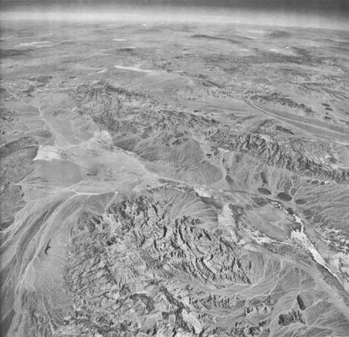
| High-altitude oblique aerial photograph to north-northeast from a point approximately above Skidoo, Panamint Range. Death Valley extends obliquely across center of photograph, Funeral Mountains (right) and Grapevine Mountains (left) lie beyond. The Amargosa River flows touthward through the Amargosa Desert from its headwaters area in upper left-center of photograph. The Northern Death Valley—Furnace Creek fault zone farms a modest trace near the base of the fans extending into Death Valley from the Funeral and Grapevine Mountains. Tucki Mountain occupies center foreground. Photo U.S. Air Force 374L 190, 6 September 1968; courtesy of the U.S. Geological Survey. |
| <<< Previous | <<< Contents >>> | Next >>> |
state/ca/cdmg-sr-106/sec4.htm
Last Updated: 24-Jul-2009
