|
California Division of Mines and Geology
Special Report 106 Geologic Features—Death Valley, California |
Stratigraphy and Depositional Environments of the Crystal Spring Formation, Southern Death Valley Region, California
Michael T. Roberts1
1Pennsylvania State University, University Park, Pennsylvania 16802.
INTRODUCTION
This report is a summary of a study of the lower and middle part of the Crystal Spring Formation in the southern Death Valley region begun in 1972. The lower three members of the formation have been studied throughout the region; the dolomite and algal members were investigated at selected localities. The upper two members and the diabase sills in the formation were not studied, and data pertaining to them in this report are primarily from Wright (1968).
The late Precambrian Crystal Spring Formation is exposed within a 75 by 25 mi (121 by 40 km) belt that trends approximately east and extends from the Kingston Range to the southern Panamint Range. The Crystal Spring is the lowest of three formations of the Pahrump Group. It rests with profound unconformity on older Precambrian metamorphic and igneous rocks, and it is successively overlain by the Beck Spring Dolomite and the Kingston Peak Formation. The older Precambrian complex has been dated at 1,700 m.y. (Wasserburg and others, 1959). Diabase sills within the Crystal Spring have been correlated with sills 1,200 m.y. old in Arizona on the basis of their similarity in composition (Wrucke, 1972). The Crystal Spring Formation contains Baicalia stromatolites (Howell, 1971); this suggests a middle Riphean age (1,350 to 950 m.y.) for the algal member of the formation. The algal member also contains Conophyton stromatolites. Raaben (1969) suggests that the Baicalia-Conophyton association is typically middle Riphean. The age may be, then, between 1,350 and 1,200 m.y.
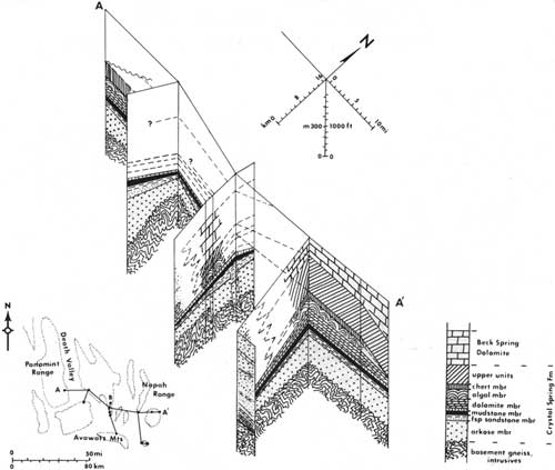
The Crystal Spring Formation is divisible into seven sedimentary members (Fig. 1) and contains diabase sills that range in thickness from a few tens of feet to about 1,500 ft (457 m). The sills are not shown in Figure 1 in order to better show the relations of the sedimentary members. The lower four members, redefined below from those of Wright (1968), are each remarkably persistent throughout the region, varying in thickness but not markedly in lithology. The thickest diabase sill generally occurs within the basal part of the dolomite member, but sills also occur higher in the section in several areas, and feeder dikes are exposed locally. Contact metamorphism has altered the rocks for a distance, generally, of 100 to 150 ft (30 to 46 m) on both sides of the sill. Below the sill, in most exposures, are hornfelsic calc-silicate rocks (the "upper quartzite member" of Wright, 1968, here included with the dolomite member) which were originally impure carbonate rocks rich in quartzose sand and shaly strata. In most areas above the sill dolomite beds have been altered to talc-tremolite rocks, which are extensively mined in the area (Wright, 1968).
|
| Figure 1. Fence diagram of Crystal Spring Formation. Vertical exaggeration x 26. Location of measured sections (vertical lines of diagram) shown as dots on inset map. Generalized stratigraphic column inset represents northern lithologies. Lithologic changes to south are shown diagrammatically on three southernmost sections. Data for chert, upper units, and Beck Spring Dolomite from Wright (1968). Data for Silurian Hills section in part from Kupfer (1960). (click on image for a PDF version) |
The upper part of the dolomite member and the upper three members (Fig. 1) are persistent in northern and central exposures but apparently show marked facies changes to the south. The southern facies are restricted in outcrop to the Silurian Hills and northern Avawatz Mountains. The exact relation of the northern to southern facies is unknown, because they are separated by a 5-to 15-mi (8- to 24-km) interval in which the Crystal Spring is not exposed, and, also, because of a lack of detailed data on the upper members.
ARKOSE MEMBER
The arkose member of the formation is here defined as the arkosic sandstone and conglomerate between the basal unconformity and, generally, the top of the uppermost layer of conglomerate. The upper boundary is generally marked by the upward change in color from mainly gray and green to the red or purple of sandstone of the overlying member. In some areas—for example, the Owlshead Mountains—the uppermost conglomerate is absent and the top is defined on the basis of bedforms and color change. In other areas, such as the southern Panamint Range, the conglomerate is present, but the color change occurs within rather than above it. Preliminary petrologic study indicates that the boundary also separates more feldspathic strata from overlying less feldspathic strata, although the change may be gradational.
The member is composed of about 60 percent sandstone and 40 percent conglomerate. Thin beds of shale, siltstone, chert, and carbonate are very subordinate and occur within the finer-grained parts of the member. Thin sections of the member (36 thin sections, 500 points counted per thin section) indicate an average composition of 35 percent quartz grains (mainly undulatory extinction), 22 percent matrix (mainly illitic material), 20 percent rock fragments (15 percent polycrystalline quartz, 5 percent granitic), 17 percent feldspar (albite, microcline, orthoclase), and 6 percent accessory minerals (calcite, opaque minerals, mica, heavy minerals). Much of the matrix appears to be authogenic and derived from the feldspars. "Ghost" grains of feldspar are abundant in the matrix, and the feldspar displays all stages of alteration to illitic material. Consequently, the original feldspar content of the member may have exceeded 30 percent. The rock fragments, heavy minerals, and abundance of alkali feldspar indicate a source containing granitic igneous and metamorphic rocks. The basal and uppermost beds of the member tend to be more quartzose than the rest of the member, trending toward feldspathic sandstone in composition. Variations in quartz/feldspar ratios in the member seem to be related to differences in degree of alteration of feldspars in the sediment and to changes in weathering or composition in the source area, rather than to differences in depositional environment.
Thickness trends of the arkose member and the initial geometry of the depositional basin of the formation are shown in Figure 2. The arkose member contains a basal conglomerate unit as much as 27 ft (8 m) thick, which locally pinches and swells, but which appears to increase in thickness from about 4 ft (1.2 m) to more than 20 ft (6 m) east-southeastward. It consists of pebbles and cobbles composed mainly of metaquartzite and white quartz in a matrix of very coarse feldspathic sandstone. Exposures of this conglomerate in the central part of the region display a clast imbrication. Measurements of clast orientation indicate southerly flowing currents. The basal conglomerate is overlain in many areas by conglomeratic strata (described below) with cross strata that show southerly current directions; it is probably fluvial in origin. In the eastern Kingston Range, the basal conglomerate appears to be part of a fining-upward fluvial sequence. The basal conglomerate contains scour-and-fill structures and potholes at its base. However, in some areas—for example, the southern Ibex Hills—the conglomerate is overlain by cross-stratified tidal sandstone beds, which show northerly current directions (described below). The basal conglomerate thus may be the product of complex nearshore processes during the initial transgression over the area. It may, in part, represent a transgressive, cobble beach deposit. The conglomerate appears to have been derived primarily from the erosion of underlying rocks. In the southern Panamint Range, for example, it contains clasts of schist and vein quartz identical with the underlying rocks. The metaquartzite of the clasts is unlike any known older rocks exposed in the region. They may represent redistributed clasts from gravel that formerly overlay the basement or were transported directly from a distant source.
The rest of the member is a cyclical sequence of conglomerate and sandstone (Fig. 3) beds that contain very abundant cross strata. Generally, a cycle consists of a lower conglomeratic zone 30 to 100 ft (9 to 30 m) thick overlain by a sandstone zone 20 to 100 ft (6 to 30 m) thick. The conglomeratic zones are composed of beds of poorly sorted pebble to cobble conglomerate and very coarse sandstone. These zones are characterized by lenticular beds 1 to 6 ft (0.3 to 1.8 m) thick, commonly separated from one another by lenses of micaceous sandstone less than 6 in. (15 cm) thick. Internally, the large lenses are horizontally laminated, cross stratified, or both. The cross strata are chiefly trough types and commonly are about 6 in. (15 cm) to 1 ft (30 cm) thick, although sets of cross strata as much as 6 ft (1.8 m) thick have been observed. Preliminary determination of maximum pebble sizes in the conglomerate, excluding the basal conglomerate, indicates a decrease in size southward (Fig. 3).
Measurements of cross strata in the conglomerate revealed southerly or westerly transport directions (Fig. 2), except in the Owlshead Mountains section, where easterly directions were obtained. The directions in the Owlshead may reflect a local western source; and the western edge of the basin (Fig. 2) was drawn with a northerly trend close to this section, based on these data. The cross strata rosettes show scatter, but are unimodal or bimodal with modes generally about 90° apart. The conglomeratic zones are interpreted to be the deposits of braided streams debouching into the basin.

|
| Figure 2. Isopach and paleocurrent map of arkose member. Small arrows are mean directions of foreset dips in conglomeratic units of member. Broad arrows are directions of foreset dips in sandstone units of member. Dashed arrows are probable directions in structurally complex areas. Data represent about 1,200 foreset measurements, 13 measured sections, and observations from additional sections. Isopach interval is 200 ft. (click on image for a PDF version) |
The sandstone zones are composed of fine- to coarse grained sandstone strata. In some zones, very subordinate, discontinuous beds of chert, shale, and carbonate, a few inches thick, are interbedded with the sandstone. The sandstone is typified by tabular beds that range in thickness from several inches to 3 ft (up to 0.9 m); internally, the beds are horizontally laminated, planar cross stratified, or both. The planar cross strata range in thickness from a few inches to 2 ft (0.6 m). Herringbone cross-strata sets are common in the sandstone zones. Foreset orientations of the cross strata show little scatter, compared to the conglomeratic units, and show unimodal northerly directions in some zones and bimodal northerly and southerly directions in others. The bimodal rosettes have 180° mode separation typical of tidal currents (Fig. 2). The unimodal rosettes that show directions opposite those of the conglomeratic zones represent flood-tide-dominated environments. In the Owlshead Mountains section, the sandstone zones, like the conglomeratic zones, show anomalous directions. The east-west tidal direction of the Owlshead section supports the north-trending border of the basin shown in Figure 2. The sandstone zones are interpreted as deposits of nearshore tidal environments such as tidal deltas.
The cycles are complicated by the presence of zones of interbedded sandstone and conglomerate, which appear either to be due to small-scale interfingering of the fluvial and tidal environments or to be tidal dominated. In addition, the sandstone-conglomerate cycles are interrupted high in the member by about 100 ft (30 m) of horizontally laminated sandstone strata. This laminated zone contains scattered, contorted planar cross strata and resembles deposits of modern floods such as those described by McKee and others (1967). On the other hand, this zone may represent a tidal environment with a high regime flow.

|
| Figure 3. Variations of maximum grain size in lower members. Dashed contours are trend of maximum pebble sizes in arkose member, excluding basal conglomerate. Vertical sections are plots of maximum grain size versus stratigraphic position for selected sections on east-west and north-south lines. Arkose member is from base to top of last conglomerate "pulse" (arrow); feldspathic sandstone member is between arrow and last sandstone "pulse." (click on image for a PDF version) |
The initial site of deposition of the Crystal Spring Formation was a generally east-trending shoreline zone at least 75 mi (121 km) long. Paleocurrent data (Fig. 2) and pebble-size data (Fig. 3) indicate a northern upland source for the sediments. If one applies Sternberg's Law to the pebble-size trends from the central part of the basin (excluding the basal conglomerate), the source is estimated to have been 2 to 4 mi (3.2 to 6.4 km) north of the Eclipse mine area in the central Ibex Hills (point B on inset map of Fig. 1).2 A close source is also indicated by the angular and arkosic nature of the sediments and the near-shore character of the bedforms. Figure 3 also shows that the cyclicity of grain size is best defined in northern exposures and that the "pulses" of conglomerate are more subdued to the south. The cyclicity is interpreted as due to periodic uplift of the northern upland, possibly along a bounding fault zone. The contrast in detectable cyclicity is due to the distance from the bounding zone of the upland.
2Sternberg's Law relates pebble size (sometimes stated as weight) to distance of transport. Y = Y0e-ax where Y is the diameter of the largest pebble a given distance from some reference point; Y0 is the diameter of the largest pebble at the reference point; a was originally stated as a "wear coefficient" but is a constant probably related more to slope factors; and x is the distance between the point at which Y was measured and the reference point.
Four sections on a nearly north-south line (central panel of Fig. 1) were used for the computation. The constant a was determined using known pebble sizes and distances for this north-south line and the Sternberg equation. In order to determine the distance from the northern most point (B) to the source of the sediment, only Y0 must be known—that is, the probable maximum pebble size available in the source area. The critical assumption is that the transgressive basal conglomerate contains sizes representative of those available in the source. The maximum size observed in the basal conglomerate was 10 in. (254 mm). The range of 2 to 4 mi (3.2 to 6.4 km) was obtained by using maximum and minimum a values, based on the data, and the assumed 10-in. size for Y0. Because of these assumptions, the distance to source should be taken as only a "ballpark" estimate. For comparison, even if the source contained boulders 1 m in diameter, it would be only 24 km away.
The bedforms, directional features, and grain-size trends indicate that the sediments were transported generally southward into the basin, where the finer fraction was reworked by generally north-south tidal currents. The cyclicity is attributable to an interfingering of fluvial and tidal environments controlled by periodic uplift in the source area. The member is thus interpreted as deposited in a complex system of nearshore, high-energy environments shifting laterally and vertically through time. Fluvial and tidal sediments are essentially the same in composition and roundness and, therefore, probably resided in their respective environments long enough to acquire distinctive bedforms, but not long enough to become differentially altered before burial.
Abrupt thickness changes within the member probably reflect faulting within the basin during sedimentation, as illustrated in the central panel of Figure 1 and in Figure 6. As the member records high-energy shoreline loci of deposition with a northern upland, finer offshore facies, such as siltstone and shale, might be expected to have been present to the south of the present exposures of the member. However, in later Crystal Spring time (detailed below) the southern region was uplifted and any record of such sediment was probably lost by erosion. An alternate explanation for the lack of this facies would be that little or no fine-grained material was available in the source.
FELDSPATHIC SANDSTONE MEMBER
The feldspathic sandstone member is here defined as the red to purple sandstone, siltstone, and shale that lie above the arkose member and below massive, purple mudstone. The top of the member is everywhere marked by a layer of coarse sandstone, generally only a few feet thick, which is represented by the last "pulse" in Figure 3. The isopach map of the member (Fig. 4) shows similar trends to that of the arkose member, indicating little change in the geometry of the basin. The feldspathic sandstone, however, may have extended farther northward beyond the northern limits of the arkose member.

|
| Figure 4. Isopach and paleocurrent map of feldspathic sandstone member. Arrows represent mean directions of foreset dips. Dashed arrows are probable directions in structurally complex areas. Data represent 356 foreset measurements and 13 measured sections. Isopach interval is 100 ft. (click on image for a PDF version) |
The basal part of the member consists of tabular beds of fine- to coarse-grained sandstone generally less than 1 ft (0.3 m) thick. Internally, these beds are horizontally laminated, planar cross stratified, or ripple laminated, or they contain some combination of these features. The upper surfaces of the beds are commonly rippled. All types of ripples were observed, including interference ripples, oscillation ripples, lunate/linguoid ripples, and asymmetric ripples. The beds are commonly separated from one another by shaly partings exhibiting mudcracks. The planar cross strata are, in places, arranged in herringbone sets or show evidence of reactivation by opposing currents, as in tidal environments. This basal zone is 100 ft (30 m) or more thick in the central part of the basin, but elsewhere ranges from 30 to 70 ft (9 to 21 m) thick. Orientations of cross strata in the sandstone reveal unimodal northerly current directions at some localities. At other localities, bimodal, generally north-south currents are indicated (Fig. 4). Ripple directions, on the other hand, show multimodal directions typical of intertidal sand bodies. As in the arkose member, the Owlshead Mountains section shows western directions. The current directions are interpreted as due to tidal currents, with the unimodal northerly directions forming in areas dominated by flood tides.
The sandstone zone comprises most of the member at some localities. Ordinarily, however, the zone grades upward to shaly strata which form as much as 60 percent of the member. The sandstone of the lower part of the member generally grades upward into interbedded sandstone, siltstone, and shale which form cycles composed of fining-upward sequences typical of prograding tidal-flat deposition. The sandstone layers contain planar cross strata and ripples like those of the lower part of the member. The silty and shaly layers are thinly laminated and contain abundant mudcracks and shale-chip conglomerates formed from the breakup of mudcrack polygons. These features support an intertidal origin for these rocks. The fining-upward sequences range in thickness from about one to several meters. The thickness of fining-upward tidal sequences approximates the paleotidal range (Klein, 1971); however, the thicker sequences probably reflect subsidence more than the vertical distance between high and low tides. An approximate water depth of 0.5 m in one area was calculated from the grain size and wavelength of oscillation ripples in a fining-upward sequence.3 The zone composed of interbedded sandstone, siltstone, and shale generally grades upward into shaly strata. Thus, the whole member forms a fining-upward sequence on a large scale, grading upward from sandstone to sandstone, siltstone, and shale and, finally, to shale. Locally, for example, in the Ibex Hills, where the member shows abrupt increases in thickness, it consists of repetitions of the large-scale fining-upward sequence. These thickness changes seem to be related to faulting in the basin during deposition of the sediments, as illustrated in Figures 1 and 6.
3 Harms (1969) has shown that wave period (T) can be calculated from T = π(Emax/Uw max) where Emax = average ripple crest spacing and Uw (current velocity) must exceed about 19 cm per sec for fine sand. Using crest spacing of 5 cm for one Crystal Spring sample of rippled fine sandstone, T = 0.826 sec. If the maximum depth of wave-affected rippling is about 4/9&lamda;, and &lamda; = (g/2π)T2, then 4/9&lamda; (maximum depth for the oscillation ripple above) would be 47cm.
The member is interpreted as representing nearshore tidal sand bodies (lower part) and tidal flat (middle and upper part) deposits. The tidal current directions, like those of the arkose member, indicate northerly flood tides and southerly ebb tides. The fining-upward sequences suggest that the tidal flats pro-graded southward over the basin. The lack of sediment coarser than coarse sand and the abundance, as well as the lowermost occurrence, of shale indicates that the relief of the northern source, which was relatively rugged during deposition of the arkose member, became subdued.
A preliminary study of thin sections obtained from the feldspathic sandstone indicates a greater percentage of quartz than in the arkose member. The quartz content of the sandstone ranges from about 35 percent to about 70 percent. The more quartzose samples contain well-rounded grains and show better sorting than samples from the arkose. The red color of the member is due to abundant hematite in the matrix of the sediments. The relatively high quartz content may be due to removal of feldspar by weathering when the source area was reduced to low relief. It also may reflect a relatively long residence time in the tidal environment. Deeper weathering at the source is indicated by the abundant heinatitic material in the matrix of the sediments.
PURPLE MUDSTONE MEMBER
The mudstone member is massive to poorly bedded, purple to red, silty to sandy mudstone that overlies the uppermost sandstone bed of the underlying member. It is overlain by the sandy carbonate zone at the base of the dolomite member. The mudstone member contains scattered grains of sand in its lower part and consists of laminated siltstone and shale in its upper part. The upper part in some areas is metamorphosed below the diabase sill. The member ranges from 30 to 160 ft (9 to 49 m) thick but is commonly about 125 ft (38 m) thick. It is distributed similarly to the lower members, being thickest through the central part of the basin and thinnest in the Silurian Hills. The member is termed a mudstone because it generally lacks regular parting planes, laminations, or bedding; it is poorly sorted and is clayey to silty in composition. A preliminary study of its petrology indicates that 75 to 80 percent of the mudstone is an illite-hematite mixture. The remainder consists of silt and sand grains of quartz (15 to 20 percent) and feldspar (less than 5 percent). The mudstone contains a few thin, discontinuous carbonate beds and very fine sandstone beds and is typified by bluish to greenish reduction spots. Although the member lies between strata with bedforms that indicate an intertidal environment, it is lacking in distinctive bedforms. The member is apparently the last unit of predominantly clastic material in Crystal Spring time to be derived from the northern upland, although the lack of detailed data from the upper units makes this conclusion tentative. During the deposition of the mudstone, the northern upland was very low in relief. The mudstone may represent low-gradient stream, estuary, or tidal-marsh deposits.
DOLOMITE MEMBER
The dolomite member is here defined as the chiefly dolomitic strata that include the sandy carbonate zone ("upper quartzite member" of Wright, 1968) and the lower part of the "carbonate member" of Wright (1968). The sandy carbonate strata are about 100 ft (30 m) thick across the northern and central parts of the basin and thin southward to less than 50 ft (15 m) in the Silurian Hills. This part of the member does not show a north-south facies change.
In the southern occurrences of the dolomite member, the beds that overlie the sandy zone consist of a zone of dolomite 50 to 100 ft thick (15 to 30 m), in turn overlain by several hundreds of feet of interbedded quartzite, dolomite, shale, and limestone. In the northern exposures, the basal sandy zone is overlain by dolomitic strata as much as 300 ft (91 m) thick. The dolomitic strata display a cyclicity expressed by alternating layers of two types of dolomitic rock. One type consists of light-gray to light-brown dolomite that weathers to various shades of orange. It is very fine grained and contains scattered quartz sand grains, zones of dolomite intraclasts, and subordinate chert beds. It is characterized by wavy to irregular laminations and locally shows ripple cross laminations. The irregular laminae resemble those formed by algal mats. Layers of this type of dolomitic rock range from 1 to 30 ft (0.3 to 9 m) thick and are thickest low in the member (Fig. 5).

|
| Figure 5. Stratigraphic column of carbonate members in Alexander Hills area. Lower inset details lithologies of single cycle of dolomite member (solid black units of column correspond to upper, ribbed strata of inset; solid white units of column correspond to lower strata of inset). Upper inset details stromatolite cycles within basal zone of larger stromatolitic cycles of algal member. At top of dolomite member is zone of rippled and cross-stratified clastic limestone. |
The other type of dolomitic rock is very thinly bedded, medium- to dark-gray siliceous dolomite. This type contains thin, wavy laminated beds of dolomite that alternate with thin layers of microcrystalline quartz. On weathered surfaces the latter stand out as brown ribs. The thin layers are typically contorted into folds apparently caused by soft-sediment deformation. The wavy laminae of the dolomite are archlike in places and resemble those produced by algal mats. Layers of this siliceous dolomite range from 1 to 15 ft (0.3 to 4.6 m) thick and increase in thickness and abundance upward (Fig. 5). The top part of the dolomite member in its northerly occurrences consists of a unit of clastic limestone as much as 30 ft (9 m) thick. This unit is composed of sand- to silt-size limestone clasts and contains quartz sand lenses. It is commonly rippled and shows small tidal cross laminations.
Although the dolomite member is about 400 ft (122 m) thick in the Alexander Hills, only 100 ft (30 m) of similar strata can be recognized in the Silurian Hills, 15 mi (24 km) to the south. Either the member simply thins to the south as do lower members, or in the south the upper part is replaced by chiefly quartzitic strata.
The alternation of the two types of dolomitic rock in the northern exposures of the dolomite member is interpreted as due to interfingering of rocks of two depositional environments. The light-gray to light-brown dolomite unit is interpreted as deposited in the higher-energy environment, possibly in a low intertidal or subtidal zone. The siliceous dolomite unit is interpreted as deposited in a lower-energy environment, possibly in a high intertidal or supratidal zone. As the strata that possibly indicate a high intertidal or supratidal environment become more common upward, the sequence can be attributed to prograding (regressive) carbonate tidal-flat deposition. The clastic beds at the top of the member in the northern exposures may represent transgression or the return of high-energy tidal environments, possibly related to uplift in the south, as indicated by the quartzose sand in the upper part of the dolomite member there.
ALGAL MEMBER
In the northern exposures of the dolomite member, it is overlain by a carbonate unit, as much as 300 ft (91 m) thick, and characterized by abundant stromatolitic structures. It is here designated as the algal member. It consists of limestone, except in the Saratoga Hills where it is dolomitic. The member contains cyclical repetitions of morphologically different stromatolite forms and includes about 50 ft (15 m) of non-stromatolitic limestone and dolomite at the top. The nature of the cycles varies from place to place. The cycles in the southern Panamint Range and the Alexander Hills are similar. In the Kingston Range and Saratoga Hills, different sequences of stromatolites were observed.
In the Alexander Hills (Fig. 5), a typical cycle consists of a well-defined basal zone, itself cyclical, overlain by massive zones containing as many as three stromatolite forms. The lowermost cycle in the Alexander Hills is considered to be complete. It consists of a basal zone, 12 ft (3.7 m) thick, composed of cyclical repetitions of the sequence: wavy laminae—algal heads—Baicalia columns—silt and chert (Fig. 5, upper inset). This sequence is repeated as many as five times in the basal zone. If intertidal models of Holocene stromatolites apply, this zone may represent transgressive intertidal sequences.
Overlying the basal zone is a bed, 8 ft (2.4 m) thick, consisting entirely of vertically stacked algal heads tending toward columnar development. This is followed by a massive limestone bed, 45 ft (13.7 m) thick, which appears to be composed entirely of algal heads, typically laterally linked, 3 to 4 in. (7 to 10 cm) in diameter. The upper zone of the lowermost cycle is 17 ft (5 m) thick and consists entirely of algal heads about 1 ft (30 cm) in diameter. These upper zones may represent slight regression, followed by relative stability of environment during subsidence prior to the next transgressive basal zone.
Each of the cycles that overlies the lowermost cycle in the Alexander Hills contains the basal Baicalia-bearing zone, but the successive zones may differ slightly from those of the lower most cycle. Commonly the zone characterized by stacked algal heads is missing, and stacked algal heads occur within the zone of laterally linked small heads. The large (1 ft) heads are absent in some cycles. As independent evidence of an intertidal environment for the stromatolites, such as dessiccation features, has not been found, they may have inhabited subtidal areas. The elliptical shape, in plan view, of many of the heads indicates that they grew in current-influenced areas.
In the southern Panamint Range and Saratoga Hills, cylindrical Conophyton forms are interbedded with forms possibly of intertidal origin. The relations are not everywhere clear, but Conophyton may have grown in low intertidal environments, as in one area they lie between possibly low intertidal and mid-intertidal stromatolites in a vertical sequence. The Conophyton cylinders, generally 2 to 3 in. (5 to 8 cm) in diameter and less than 2 ft (0.6 m) long, are inclined and parallel. They apparently grew in that position and may have been aligned with tidal currents.
The algal member of the northern localities probably grades southward into strata composed chiefly of quartzite interlayered with subordinate limestone. The cycles in the algal member thus may be related to periodic uplift of the southern area, which was shedding quartz sand into the basin. The dolomite and algal members record persistent carbonate shelf environments over the northern part of the basin. The northern upland, which was emergent during deposition of the lower members, is not evident in the two carbonate members. The carbonate shelf thus probably extended northward beyond the limits of the lower members.
The large volume of carbonate in these members may have originated from carbonate-secreting algae or from precipitation of carbonate as a result of photosynthetic activity of the algae; however, many of the stromatolite forms are analogous to those created by the trapping of carbonate debris in Holocene stromatolites.
CHERT AND UPPER UNITS
The upper two members of the formation have not been studied in detail. (Their distribution is shown in Fig. 1.) The chert is dark, dense, and fine-grained massive rock, 1 00 to 500 ft (30 to 152 m) thick (Wright, 1968). The upper sedimentary units are composed of shale, sandstone, and dolomite 200 to 1,200 ft (61 to 366 m) thick (Wright, 1968). Both chert and upper sedimentary units occur only in northern exposures and may be lateral equivalents of quartzite and conglomeratic strata to the south (Fig. 1). These members, then, may be northern basin facies deposited from the rising southern land mass that began to form earlier in Crystal Spring time.
SUMMARY
The Crystal Spring Formation consists of sediments deposited during the initiation of a late Precambrian intracratonic trough. Figure 6 outlines the main stages in the history of the basin in Crystal Spring time. Apparently after an initial marine transgression, a trough formed and was filled with coarse arkosic debris derived from a rugged northern upland that was probably uplifted along a fault (Fig. 6, stage 1). When uplift ceased, the upland was worn down, and, first, tidal-flat sand and mud, then mud possibly of fluvial origin prograded over the basin (Fig. 6, stage 2). The rest of Crystal Spring time was dominated by deposition of quartzose detritus in the southern part of the basin, while, first, algal carbonate shelf sediments, then shale-rich clastic sediments were being deposited over the central and northern parts of the basin (Fig. 6, stage 3). The quartzite and conglomerate of the southern part of the basin were probably derived from a rising southern upland. These major tectonic elements—the trough and the northern and southern uplands—first active in Crystal Spring time, were persistent features, controlling sedimentation throughout the rest of late Precambrian time (Wright and Troxel, 1967; Wright and others, 1974).

|
| Figure 6. Summary diagram of general development of Crystal Spring basin. Section is composite north-south cross section through center of basin. Exact position of southern upland no known. See text for details of stages. (click on image for a PDF version) |
REFERENCES CITED
Harms, J. C., i969, Hydraulic significance of some sand ripples: Geol. Soc. America Bull., v. 80, no. 3, p. 363-396.
Howell, D. G., 1971, A stromatolite from the Proterozoic Pahrump Group, eastern California: Jour. Paleontology, v. 45, no. 1, p.48-51.
Klein, G. deV., 1971, A sedimentary model for determining paleotidal range: Geol. Soc. America Bull., v. 82, no. 9, p. 2585-2592.
Kupfer, D. H., 1960, Thrust faulting and chaos structure, Silurian Hills, San Bernardino County, California: Geol. Soc. America Bull., v. 71, no. 1, p. 181-214.
McKee, E. D., Crosby, E. 3., and Berryhill, H. L., 1967, Flood deposits, Bijou Creek, Colorado, June 1965: Jour. Sed. Petrology, v. 37, no. 3, p. 829-851.
Raaben M. E., 1969, Columnar stromatolites and Isle Precambrian stratigraphy: Am. Jour. Sci., v. 267, p. 1-18.
Wasserburg, G. J., Wetherill, G. W., and Wright, L. A., 1959, Ages in the Precambrian terrane of Death Valley, California: Jour. Geology, v. 67, p. 702-708.
Wright, L. A., and Troxel, B. W., 1967, Limitations on right-lateral, strike-slip displacement, Death Valley and Furnace Creek fault zones, California: Geol. Soc. America Bull., v. 78, p. 933-950.
Wright, L. A., 1968, Talc deposits of the southern Death Valley—Kingston Range region, California: California Div. Mines and Geology Spec. Rept. 95, 79 p.
Wright, L.A., Williams, E. G., and Troxel, B. W., 1974, Late Precambrian sedimentation, Death Valley, evidence of prolonged and varied tectonic control of a basin and shelf environment: Geol. Soc. America, Abs. with Programs (Cordilleran Sec.), v. 6, no. 3, p. 278.
Wrucke, C. T., 1972, Correlation of Precambrian diabase in Arizona and California: Geol. Soc. America, Abs. with Programs (Cordilleran Sec.), v. 4, no. 3, p. 265.
This research was supported by NSF Grant GA—16119.
| <<< Previous | <<< Contents >>> | Next >>> |
state/ca/cdmg-sr-106/sec6.htm
Last Updated: 24-Jul-2009