
|
North Dakota History
Geology of the South Unit, Theodore Roosevelt National Memorial Park |
GEOLOGY
(continued)
Physiographic History of the Little Missouri River
The foregoing praragraphs have in a cursory fashion set the scene for the later history of the Park, namely the formation of the present scenic features. After the deposition of the Tongue River formation, a long time elapsed during which there was little deposition of sedimentary materials in this area. Probably erosion of the upper surface of the Tongue River formation was taking place as well as its compaction and solidification. There is evidence to show that to the eastward, the formations of the Eocene period the period following the Paleocene in Cenozoic time (See Fig. 1), were laid down but in the Park area they have all been eroded if they ever were deposited.
As Cenozoic time advanced, erosion of this region continued and an erosion surface called a peneplain was fairly well developed by the end of Eocene time. On this surface, there were streams meandered around depositing material here and there in their channels. Some of these stream deposits and lake deposits were laid down in the Oligocene period, the period of the Cenozoic which followed the Eocene. Only isolated remnants of these deposits exist today in North Dakota capping some of the higher buttes such as Black Butte, (the highest point in the State,) Sentinel Butte, Flattop Butte and Killdeer Mountains.
After the deposition of the Oligocene sediments, the erosion continued probably at an accelerated pace due to renewed uplift in the west and the area was worn down again to another near-level surface. On this surface, a number of streams were running; today, only remnants of their former courses remain. The Little Missouri was probably one of these streams although it is not flowing in exactly the same course and was not bordered by the same extensive badlands as today.
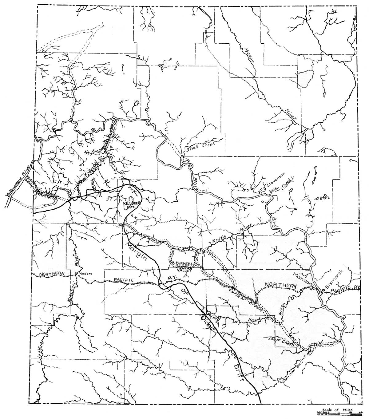
Then, as now, the Little Missouri headed far southward in Wyoming not far from Devils Tower and flowed more or less straight northward until it joined the Yellowstone River which was then flowing northward up the valley that is now known today as the Little Muddy Valley, east of Williston (See Fig. 2). Near the present site of Crosby, the Yellowstone then joined the Big Missouri which at that time was flowing northeastward to Hudson's Bay. The Little Missouri then was probably a much larger stream than it is now and was flowing in a broad shallow valley which now stands at an elevation some 200 feet above its present level in the present south Roosevelt Park area. This old level can be seen as remnants today, for example Johnson Plateau on the southwest boundary of the Park and Big Plateau northwest of the Peaceful Valley Park Headquarters. Gravel deposits on this old level can be observed at the site of the Medora airport in the SE1/4 Sec. 23, T. 140 N., R. 102 W. (See Fig. 4)
|
| Figure 2. Sketch map showing old Pleistocene valleys in western North Dakota modified from Leonard. (click on image for an enlargement in a new window) |
At the end of Pliocene time and at the beginning of the Pleistocene period of the Cenozoic era, the Little Missouri began to experience a series of changes. In the first place, the headwaters of the Belle Fourche River in South Dakota which were located near the headwaters of the Little Missouri in Wyoming and South Dakota had been eating headward rapidly and actually captured the headwaters of the Little Missouri. This left the Little Missouri without some of the water with which it had normally been carrying its load of sediment. It then probably began to deposit some of this sediment along its course and the gravels that have been noted above may be part of such sediments.
The next thing that happened to the river was that its outlet was blocked by the advancing ice sheet which formed in Canada and which was moving slowly but relentlessly southward. This caused the waters of the Missouri, the Yellowstone and the Little Missouri as well as numerous lesser tributaries to be diverted southward and southeastward across western North Dakota in a series of channels most of which are now dry. After the ice melted, it is questionable if these rivers ever entirely returned to their original courses, but stayed in their new-found channels. The Little Missouri was one of these and its course from the great bend in the Little Missouri to the present day Big Missouri was formed at this time (See Fig. 2).
The elevation of the new mouth of the Little Missouri was considerably lower than it had been when it joined the old Yellowstone just east of present day Williston. Therefore, it began to downcut rapidly with the result that its tributaries also began to cut gullys on a grand scale and the formation of the badlands began. This badland formation progressed rapidly upstream and has to date reached about the present Bowman-Slope county Line in North Dakota.
From the great bend of the Little Missouri southward, the badlands are within the old valley formed when the stream was flowing northward to the Yellowstone. In the Medora area, there is then, a valley within a valley, as the badlands are largely confined to the dissection of the old valley surface. As a result, only here and there are remnants of the old valley seen.
The work of running water is the most effective agent in the formation of the badlands but several other factors have aided and abetted this agent. These are: the nature of the formations and the effect of the burning lignite.
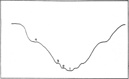
The complete story of the history of the Little Missouri River is incompletely known and will not be fully known until the terraces along the valley have been completely studied along the entire course of the river. However, in the south Park area, there appear to be at least four terrace levels including the uppermost level which represents the old valley stage mentioned previously (See Fig. 3). All of these terraces are composed largely of alluvial or lake deposits particularly in the lower stretches of the terraces nearest the present day streams. Farther up each of the tributary streams, the terraces appear to be cut on bed rock as they have little or no alluvium covering their surfaces.
|
| Figure 3. Diagram showing various terrace levels along the Little Missouri River in the South Roosevelt Park area. |
At this point some explanation might be given as to the way in which terraces are formed along streams. In general, there are two types, those that are formed along streams by the planation of the valley bottom by the streams themselves and those which are cut from previously deposited alluvium or lake deposits along the streams. Both types may be closely related and can be found in the same area. Both types are relatively flat-topped but the terraces cut from previously deposited alluvium are apt to be more flat-topped than the true planation terraces.
In the formation of the first type, the stream swings back and forth along its course cutting first one side of the valley and then the other. In this way, providing that it does not downcut vertically very much, a relatively flat surface will be developed in the valley bottom along the stream. This surface will slope gradually up the tributary streams as these streams are also cutting in much the same fashion. The extensive development of such a surface demands that the stream be flowing at that level for a considerable period of time so that the work described above can be undisturbed.
In the second type of terrace formed from alluvium previously deposited, certain conditions of the stream's history are involved. First, the stream cut a deep valley and then this valley was filled by alluvium due to a change in the regimen of the stream. At some later date, it began to downcut vertically again leaving portions of the alluvium along the valley sides uneroded. These are called terraces.
The cause of renewed stream downcutting may be that the stream has gained more water, it may have lost part of its load it was formerly carrying or there may have been an increase in the gradient of the stream due to regional uplift.
Just below the upper old valley (No. 4 level), is the terrace level which will be called in this report No. 3 level. It is about 125 to 150 feet below the No. 4 level (See Fig 5). This level is apparently an important one in the Park as much of the badland area appears to be related to this level after the development of the No. 4 level. This like all the levels, slopes steeply upstream on each of the tributaries away from the present Little Missouri. On its surface are some gravels and silts. One difficulty in delimiting this level is that it tends in many places to merge with the level below namely the No. 2 level. In other places, the scarp between the two is quite sharp.
|
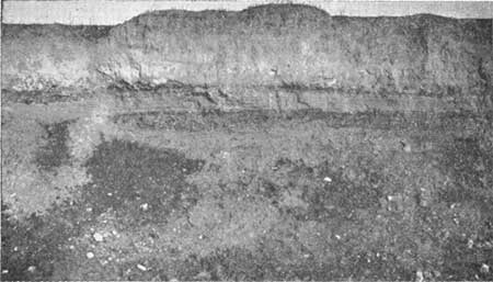
| Figure 4. Gravels and silts deposited on the No. 4 terrace level near Medora airport. |
|
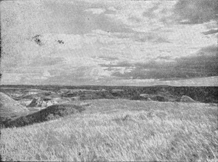
| Figure 5. View to the southeast from Big Plateau showing the No. 4 terrace level (upper) and the No. 3 terrace level (lower). |
In order to explain this and the lower terraces, it is necessary to take into account their relative positions and the fact that the surfaces of the terraces are more often than not covered with alluvial material. One hypothesis that can be offered is that after the cutting of the upper old valley level, there was a time when the river was very active and cut a deep valley down to at least and probably deeper than its present level. Then came a period of ponding possibly associated with the advance of the ice sheet and the stream was forced to drop its load in this deep valley. Subsequent to this filling, the stream began again to downcut and level No. 3 was formed. As was noted previously, this appears to have been a fairly extensive level and probably represents a greater time lapse than the levels following.
Away from the main stream the No. 3 level developed more as a planation surface while in the main valley the cutting was done primarily on previously deposited alluvium or lake sediments. After the development of No. 3 level, there was another period of re newed downcutting and the No. 2 level was formed.
The No. 2 level is the one which is most extensive today along the present stream and is about 27 feet below the No. 3 level and about 13 feet above the No. 1 or present-day stream level (See Fig. 6). It is the level on which the Peaceful Valley Park headquarters are located. As noted previously, there is some doubt if this level can be distinguished from the No. 3 level. To the writer, it seems that this can be done but in a number of places, the No. 2 level has so regraded the No. 3 level that the two cannot be separated.
|
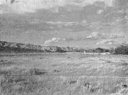
| Figure 6. View just south of Park Headquarters near picnic area showing No. 2 terrace level in foreground and No. 1 (present stream) level in background. |
After the cutting of the No. 2 level, the stream again experienced a period of downcutting and the present stream level is the result. At the present time, it would appear that the stream is probably not downcutting extensively but instead is aggrading its channel.
| <<< Previous | <<< Contents >>> | Next >>> |
state/nd/1950-17-4/sec1a.htm
Last Updated: 28-Mar-2006