
|
North Dakota History
Geology of the North Unit, Theodore Roosevelt National Memorial Park |
REGIONAL GEOLOGIC SETTING OF THIS AREA
Originally, this area is a part of the Missouri Plateau. According to Fenneman2 "the Missouri Plateau comprises all that part of the Great Plains province which lies north of the High Plains to an undetermined boundary in Canada. Its southern limit is the Pine ridge. . . well shown on the geological map because of the high formations which underlie the High Plains of the south are absent in the north . . . Along its eastern boundary, the Missouri Plateau is itself being consumed by the gradual westward spread of the Central Lowland. Here the two provinces, Central Lowland and the Great Plains are separated by an indefinite escarpment. . ."
2Fenneman, N. M., Physiography of the Western United States, McGraw Hill Book Company. New York, p. 61, 1931.
A good description of the northern Great Plains is given by William C. Alden.3 "The Northern Great Plains rise gradually westward from altitudes between 1800 and 2400 feet above sea level on the Coteau du Missouri, east of the Missouri River in North Dakota to 5000 or 6000 feet at the foot of the Rocky Mountains. The Rocky Mountain front in general rises above the prairies, and a short distance back from the front are peaks rising to altitudes of 9000 or 10,000 feet in Glacier National Park and 11,000 to 13,000 feet or more in The Big Horn Mountains and the rugged region north and east of Yellowstone Park. In this connection, attention may be called to the fact, which is probably already familiar to many, that the country east of the mountains, though known as the northern Great Plains is far from being smooth, flat surface. It is true that there are some flat tracts and large gently rolling areas. And that to an observer on a high point in the mountains, the whole vast plain looks as flat as a floor in contrast with the boldness of the mountain ridges. This impression is, however, due to the fact that the features are much smaller and lower than the mountains and that the details are lost in the hazy distances. Particularly, outside of the drift covered part of the plains —that is, in most of the plains regions south and west of the Missouri River there are large areas of very rough country. Typical badlands occur in the breaks along the Missouri and Yellowstone Rivers, where there is deep and thorough dissection, and in the larger inter-stream tracts ridges rise in places 500 to 1500 feet above the valley bottoms, with many bold cliffs and picturesque towers and pinnacles, especially where the eminences are capped with sandstone.
"The Missouri and Yellowstone Rivers flow for the most part in rather narrow young valleys bordered by lines of abrupt bluffs 100 to several hundred feet in height. In many places on the Missouri River below Great Falls, Marias River, the Teton, the lower Musselshell, and the Little Missouri the inner valleys are narrow gorges approached with difficulty except on the main graded roads".
3Alden, William C., Physiography and glacial geology in eastern Montana and adjacent areas. U. S. Geological Survey Prof. Paper 174, P. 3, 1932.
The section of the Missouri Plateau in which the North Unit of the Theodore Roosevelt National Memorial Park is found is that portion of the Missouri Plateau which has been glaciated. The glacial effects of this area are not particularly evident from the standpoint of glacial deposition, but the glacier did make marked changes in the drainage of this area which, in fact, is the backbone of the story of the recent geology of the Park area. Here and there in the Park area are found evidences of the former glacier. These include small amounts of glacial drift as well as glacial erratic boulders consisting of rocks foreign to this area. However for the most part, deposition of glacial materials can be disregarded in this area as the amount of the material is relatively small.
|
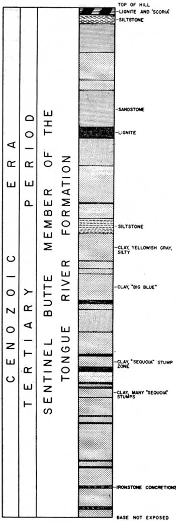
| FIGURE 3. Geologic section measured in the SW1/4 NE1/4 Section 33, T. 148N., R. 99W. illustrating the nature of the Sentinel Butte member of the Tongue River formation. |
| <<< Previous | <<< Contents >>> | Next >>> |
state/nd/1956-23-2/sec2.htm
Last Updated: 28-Mar-2006