
|
North Dakota History
Geology of the North Unit, Theodore Roosevelt National Memorial Park |
PHYSIOGRAPHY
In order to understand the scenery you see about you in the North Unit, it is necessary to call upon your imagination extensively. Most of the land forms you see about you are very young, geologically speaking.
Going back to the Pliocene which was about 1,000,000 years ago, this area was a broad rolling plain much like that you can see now in the uplands west and north of the North Unit of the Park. On this surface were somewhat higher hills forming drainage divides. One of these old divides is represented by the present day Killdeer Mountains. On this old surface were numerous streams of which the biggest in this area was the Little Missouri.
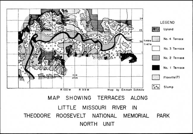
Now let us set the scene for the beginning of many drainage changes. The Killdeer Mountains were a drainage divide with streams flowing west from it to join the Little Missouri and streams flowing east to join some streams (including possibly a pre-glacial Missouri River), the exact courses of which are not now known. The Little Missouri at that time was flowing northeastward past Watford City to join the Yellowstone which in turn flowed northward to join the Big Missouri near Crosby. From near Crosby the combined streams flowed northeastward toward Hudson Bay. This level of the Little Missouri and its tributaries as well as the tributaries of various streams flowing eastward at this time from the Killdeer Mountains make the present No. 4 terrace level. The gradient of this terrace level declines east and west from the Killdeer area.
Then, at the end of the Pliocene and at the beginning of the Pleistocene there was a broad regional uplifting of the land surface causing renewed downcutting by the streams. This downcutting was particularly active on the east side of the Killdeers with the result that this stream (the Medicine Stone River) ate through, by headward erosion, or lengthening its course by erosion at its headwaters, at a narrow place in the divide at the present site of the Little Missouri River course. Thus, this stream captured first the tributaries of the Little Missouri and finally the Little Missouri itself. At this time the Little Missouri first began to flow in its present course. Probably, the reason the stream on the east side of the Killdeers could cut more rapidly was that it probably had the advantage of a steeper gradient and a lower local baselevel and thus flowed faster which enabled it to downcut more rapidly. The story of these drainage changes are somewhat more complicated than herein described but the details are not entirely necessary here. The steps in the changes are outlined in the maps of the various stages in Plate II. These maps were first prepared by Emmett Schmitz.
|
| PLATE II. Map showing the terraces along Little Missouri River in Theodore Roosevelt Notional Memorial Park North Unit. (click on image for an enlargement in a new window) |
About this time, the glaciers were forming in Canada and a climatic change was taking place resulting in increased precipitation in all of North America. This increased the flow of the Little Missouri in its new course and caused greater downcutting. It was at this time that the valley was cut most deeply and because the sides of the valleys were oversteepened by this rapid downcutting they began to slump extensively. This slumping was slow when considered from the standpoint of a human lifetime but geologically speaking, it happened overnight.
Then the glacier arrived in this area. While the ice probably stood in this valley, it did little erosive work and left practically no deposits except a few scattered boulders called glacial erratics. After it receded from the valley, it did block the eastward-flowing drainage for a time and thus caused extensive remodeling of the valley landscape.
When the drainage was blocked, a lake began to form and after reaching its maximum height (about the top of the No. 3 terrace) it must have stayed there for some time. Into this lake poured great amounts of sediment carried by the streams and by sheetwash from the surrounding hillsides. This material was reworked by the lake waves and the fine bedding we can see in some of the gully sides was the result.
This alluvial fill extended up the middle parts of some larger tributary streams such as Squaw Creek. However, the streams themselves were doing some lateral cutting so the Number 3 terrace along the sides of the tributary valleys and at their heads is actually a cut rather than a fill terrace.
After the formation of terrace Number 3 the lake was drained and the river meandered or wandered back and forth at a somewhat lower level cutting terrace Number 2 in the deposits of the Number 3 terrace. This terrace is about 25-30 feet plus or minus below terrace Number 3. Its surface is definitely a cut surface as it is somewhat irregular topographically and old meander scars can be seen on it. It still floods in very high water.
The present stream (terrace Number 1) is flowing about 15-20 feet below terrace Number 2. The stream can be seen to be meandering widely at the present level. Near the Sperati overlook the stream has cut through one of its meanders leaving a meander scar. In times of high water, it is filled forming what is called an oxbow lake. The stream undoubtedly has done this many times at all levels on which it has flowed.
An alternate hypothesis to consider for the formation of these terraces, particularly the prominent Number 3 terrace, is that they were formed at various times when the stream was overloaded without the necessity of having a lake present. In other words they were formed at times when the stream was not able to carry its entire load and thus deposited the part it couldn't carry along its course.
There are various ways a stream could be overloaded. There could be a decrease of water causing less run off. This could have happened after the ice front retreated and the glacial melt water declined in amount or it could be that there was less precipitation after the ice front retreated.
Another cause of deposition might be excessive load which was more than the stream could carry. This would cause deposition even if the amount of the water in the stream remained constant.
As can be seen, it might he possible to cause these terraces without there actually having been a lake in this area. However one point which strongly suggests ponding in the center portion of the valley at least is the laminated bedding shown in some parts of the Number 3 terrace. Then too, this terrace level is very even and does not show the meander scars and similar features present on lower terraces where the stream is known to have meandered widely.
| <<< Previous | <<< Contents >>> | Next >>> |
state/nd/1956-23-2/sec4.htm
Last Updated: 28-Mar-2006