|
Texas Bureau of Economic Geology
Padre Island National Seashore: A Guide to the Geology, Natural Environments, and History of a Texas Barrier Island |
ORIGIN AND GEOLOGIC HISTORY OF PADRE ISLAND
Padre Island is a very young geologic feature when compared with the Earth. According to the most recent estimates, the Earth is about 4.5 billion years old. Padre Island began forming as a submerged bar no more than about 4,500 to 5,000 years ago, according to radiocarbon dating of shells (Fisk, 1959); it may be as young as 3,000 to 3,500 years old (J. H. McGowen and R. A. Morton, personal communications, 1978).
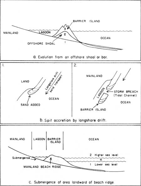
The origin of barrier islands has been debated for many years. However, it is obvious that barriers form and are modified by different processes, or combinations of processes (Schwartz, 1971), depending on such variable factors as the sediment source, the sediment type and supply, the rate and direction of relative sea-level changes, the basin shape, the slope of the continental shelf, the direction and strength of currents and waves, and the magnitude of tides. Three of the most discussed theories of barrier island origin are illustrated in figure 14. These theories are (1) development of a barrier island from an offshore shoal or submerged sandbar, (2) development by spit accretion (building) resulting from longshore drift, and (3) development by drowning of the area landward of mainland beach sand ridges (Wanless, 1974). One possible explanation for the origin of Padre Island (discussed later) is that it developed from offshore shoals (fig. 14a), with later growth aided by spit accretion (fig. 14b). The offshore shoals, however, might have been old mainland beach ridges submerged during the rise in sea level (fig. 14c). Consequently, all three processes may have played a role in the origin of Padre Island. Moreover, it is very likely that various segments of the island underwent different processes at different rates during their development.
HISTORY OF ISLAND DEVELOPMENT
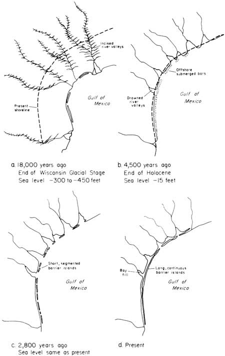
Geologists generally agree upon the basic stages in Padre Island's development, although the precise time that each stage occurred is still debated. A discussion of the development of Padre should begin with geologic events immediately preceding its origin. Figure 15 is a schematic representation of the stages leading to the formation of Texas barrier islands, based on LeBlanc and Hodgson's (1959) interpretation of the history of the Texas Gulf Coast. The figure is not meant to show the exact geography of the coastline at the various stages but rather is a series of models illustrating probable relationships among sea level, rivers, divides, subaqueous shoals, and islands.
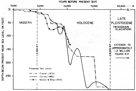
About 18,000 years ago, near the end of the final (Wisconsin) glacial stage (end of the Pleistocene1) worldwide sea level was about 300 to 450 feet lower than it is now (Curray, 1960). At that time, the shoreline was much farther gulfward on what is now the submerged continental shelf bordering the Gulf of Mexico. Rivers draining Texas carried sediments across the "shelf" and deposited them in the Gulf in areas that are now about 50 miles offshore. Upstream, however, rivers scoured deep valleys across the Coastal Plain and emergent inner shelf (fig. 15a).
1The end of the Pleistocene (ice ages) is in formally recognized as 18,000 years ago for the Gulf of Mexico; internationally, the time boundary is recognized as 10,500 years ago.
By the end of the Holocene, 4,500 years ago2, and after a long period of glacial melting, sea level reached within approximately 15 feet of present sea level (fig. 16). The final small changes in sea level have resulted from compaction of sediment, subsidence of the Gulf Coast area, and minor glacial fluctuations (Brown and others, 1976). The old river valleys carved during the lower stand of sea level were flooded (fig. 15b) and became the bays and estuaries along the present Texas coast.
2According to informal Gulf of Mexico time boundaries, the end of the Holocene occurred 4,500 years ago; according to the formal geologic time table, the Holocene continues to the present.
When sea level stabilized near today's level several thousand years ago, sand shoals, or bars, that had formed just offshore began to merge. The old submerged river-delta and barrier-island deposits laid down farther seaward during times of lower sea level (Pleistocene glacial episodes) were eroded to supply sand for the joining sandbars. As waves and currents carried the eroded sand in toward the shore from the submerged deposits and along the shore from rivers, the bars were built up and emerged as a chain of short barrier islands (fig. 15c). These initial islands were positioned primarily on the divides between the old Pleistocene river valleys. The stream valleys thus served as broad tidal passes leading to the bays and lagoons behind the emerging islands.
Much of the sand transported by longshore drift (currents moving parallel to the shore) was deposited on the downcurrent ends of the barrier islands, resulting in spit accretion (fig. 17). After a history of shifting, abandonment, and reestablishment by storm breaches, many of the tidal inlets were eventually closed. Consequently, a number of short islands were joined to form the longer islands present today (fig. 15d).

|
| Figure 17. Spit accretion. Sand carried by longshore currents is deposited on the downcurrent end of a barrier island. The upcurrent end of the adjacent island may erode, causing the tidal inlet to shift in the direction in which the currents move. The tidal inlet will be closed, however, if the rate of accretion exceeds the rate of erosion. |
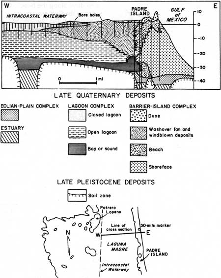
The barrier islands were built both vertically, principally by eolian (wind) processes, and slightly gulfward, by marine processes, as sand carried in from the shelf was added to the shorefaces of the islands. Padre also built lagoonward by storm washover deposition and eolian deposition (fig. 18). Today, both hurricane washovers and the wind carrying Padre's sand into Laguna Madre build the landward side of the island at the expense of the lagoon. In the line of the cross section (fig. 18), maximum thickness of Padre's sediments from sea level to the Pleistocene below is about 35 to 40 feet. Maximum total island thickness would vary considerably, however, depending on the height of the foredune ridge.
Once the modern barrier island had emerged, the wind, in addition to waves and currents, began reworking and shaping the barrier sands. All these forces, especially during storms, continue to rework the island's sediments, making Padre a barrier island with constantly changing environments. A section of this guide, The Dynamic Barrier Island, describes the processes at work on Padre, the agents responsible for them, and some of the natural records left behind.
PRESENT SHORELINE CONDITIONS
There appears to be a natural sequence of stages in the life of a barrier shoreline: (1) an accretionary, or building, phase, (2) a phase of stability, or equilibrium, and finally, (3) a stage of erosion, or destruction (McGowen and others, 1977). Various segments of Padre Island probably have experienced these phases at different rates and at different times. For example, most of the northern half of Padre's shoreline is in an equilibrium phase. The southern half of Padre, as well as much of the rest of the Texas coastline, however, is now in an erosion stage. South Padre has been in the destructional phase for a long time, probably having retreated landward (along with the lagoon and mainland shoreline) from a position farther out in the Gulf where the Rio Grande delta had once existed (R. A. Morton, personal communication, 1979). Figure 19 shows the net shoreline changes within the National Seashore over the last 100 years.

|
| Figure 19. Net shoreline changes along Padre Island National Seashore based on time periods of various lengths between 1862 and 1975. Although the shoreline immediately south of the Mansfield Channel south jetty is now accreting, over the long term that section of shoreline was erosional, as indicated here. (Modified from Morton and Pieper, 1977a, 1977b.) |
FUTURE OF PADRE ISLAND
It is difficult to predict the fate of Padre Island (as determined by natural factors) at a particular location, especially in the zone where longshore currents converge on central Padre (see the section Dynamic Gulf Shoreline). In addition, shoreline processes can be locally influenced by humans. As part of a long-term trend of erosion, however, the shoreline of Padre Island will probably retreat landward at a slow rate (Morton and Pieper, 1977a and 1977b). Three principal causes of this erosion are (1) an interruption and decrease in the sediment supply, (2) a relative rise in sea level, and (3) the impact of tropical storms.
| <<< Previous | <<< Contents >>> | Next >>> |
state/tx/1980-17/sec2.htm
Last Updated: 28-Mar-2007


