|
Texas Bureau of Economic Geology
Padre Island National Seashore: A Guide to the Geology, Natural Environments, and History of a Texas Barrier Island |
ROAD LOG
| MILEAGE | ||||||
| Interval | Cumulative | |||||
| 0.0 | 0.0 |
SEASHORE ENTRANCE (Observation Point 1). Begin the 5-mile field trip at the National Seashore entrance (fig. 112) by driving south on Park Road 22. This section of the trip is down the middle of the barrier island. For the first 0.4 mile, the grass-covered, hummocky terrain of stabilized blowout dunes (B6) can be seen on the left, adjacent to the highway. On the right is the gently sloping surface of a vegetated barrier flat (B4). At about 0.5 mile, the barren, white sands of an active blowout dune (B10) can be observed in the distance on the left. Farther down the highway, more stabilized blowout dunes are visible, this time on the right, and a vegetated barrier flat can be seen on the left.
| ||||
| 0.9 | 0.9 |
NORTH BEACH ACCESS ROAD. Turn left onto the beach access road, pass the water pumping station on the right, and continue to the beach. | ||||
| 0.5 | 1.4 |
BEACH (Observation Point 2). The beach (B1) sediments on this part of Padre consist of fine sand with very little shell material. The profile (slope) of this beach is quite gentle (fig. 113) compared with the profiles of some central Padre beaches (fig. 75). The beach berm is low, and cusps, when present, are broad and widely spaced.
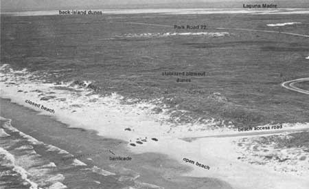
In 1968, the section of the beach between the north beach access road and the beach access road south of Malaquite was closed to vehicular traffic. Before that time, the traffic had destroyed the vegetation in the backbeach area and endangered the vegetation of the protective fore-island dunes (B3). This lack of vegetation allowed the sand to blow about freely. When the beach was closed to traffic, vegetation began to recover, and it has now advanced gulfward. An aerial view of this area (fig. 114) shows the advance of vegetation on the closed section of the beach (left) as compared with that on the open beach to the north (right). Adequate vegetation has now been reestablished on the protected backbeach, allowing fairly large coppice dunes (B2) to form in and around vegetation clumps (fig. 65).
Begin your return to Park Road 22. A short distance after leaving the beach, you will pass between high dunes that are part of the fore-island dune ridge (B3). This dune ridge protects the barrier island from the full force of hurricane winds and storm surges that strike the Texas coast. Maintenance of a healthy vegetative cover on the dunes is important, as it prevents the sand from blowing inland and leaving gaps in this natural barricade. As you continue your drive back to Park Road 22, you will pass through the stabilized blowout dunes (B6) and the vegetated barrier flat (B4) environments behind the dune ridge. | ||||
| 0.5 | 1.9 |
PARK ROAD 22. Turn left. | ||||
| 0.5 | 2.4 |
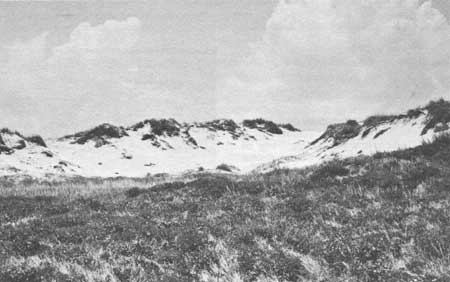
GRASSLANDS NATURE TRAIL (Observation Point 3). As part of a nature study program, the National Park Service has established a short nature trail through the grasslands of north Padre. No special equipment or boots are necessary for hiking along this trail, which is indicated by a dashed line on figure 111 and on plate. Most of the trail lies within the hummocky, grass-covered stabilized blowout dunes (fig. 115). The trail also passes near a small active blowout dune (B10) that remains barren because of trampling of vegetation by visitors straying from the trail (fig. 116). The dominant southeasterly winds cause the blowout dunes to migrate lagoonward.
Continuing southward down Park Road 22, you will pass through more stabilized dunes and a large expanse of vegetated barrier flat (fig. 81). | ||||
| 0.5 | 2.9 |
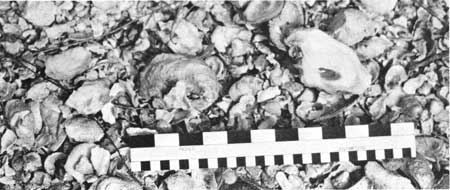
ARTIFICIALLY STABILIZED SAND (Observation Point 4). On either side of the road you may notice a cover of oystershells (Crassostrea) on the slopes of dunes that were cut when the road was constructed (fig. 117). The shells, dredged from nearby bays, have been placed there to prevent the barren sand in the road cut from blowing and reactivating these stabilized dunes. If the dune on the east (left) side of the road were reactivated, the dominant southeasterly winds would cause the dune to migrate across the road. This road maintenance problem is common in coastal dune areas.
| ||||
| 0.2 | 3.1 |
BIRD ISLAND BASIN ROAD. As you approach the Bird Island Basin road, you will see in the distance on the left the facilities of one of the petroleum companies that is actively exploring for and producing oil and gas on the island. In addition, somewhat nearer Park Road 22, the corrals of one of the historic cattle line camps, Novillo, are visible. Such line camps were used by Pat Dunn in his ranching operation (fig. 83). Turn right onto Bird Island Basin road. | ||||
| 0.5 | 3.6 |
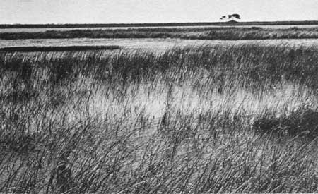
PONDS AND MARSHES (Observation Point 5). Linear wind-deflation (wind-eroded) troughs are left in the wake of back-island dune fields that are advancing lagoonward. Here on the wetter northern part of Padre, these troughs commonly become fresh-to brackish-water ponds and marshes, some of which may be seen on the south (left) side of the road (fig. 118). The troughs originate when the wind blows sand from barren areas during dry spells, deflating (eroding) the areas down to the water table. The system stabilizes during wetter spells. Alternating wet and dry periods cause a ridge-and-trough topography to develop as troughs are formed successively downwind. The troughs either are stabilized with vegetation or may collect water as do the ponds and marshes seen here. Although these water bodies generally have a short lifespan, some may retain water for several years. Typical marsh plants that inhabit the wet areas include common cattail (Typha domingensis), American bulrush (Scirpus americanus), and spikerushes (Eleocharis sp.).
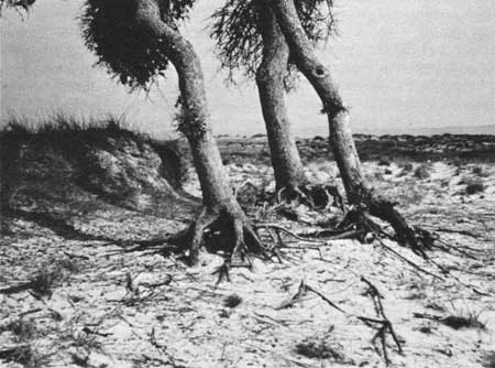
In the distance on the left, or south, side of the road is a live oak motte, or clump, of four or five trees (fig. 118). This small motte is all that remains of a much larger motte that once covered the area (Dahl and others, 1974). The trees occupy a wind-deflation flat (mapped as a sandflat, or unit B2, on plate I), which originated in the same way as the troughs occupied by the ponds and marshes. Large back-island dunes, which will be seen at Observation Point 6, migrated through the area, leaving the barren flats. Roots of the live oak trees were exposed (fig. 119) as wind eroded the sand around the trees, supplying it to the migrating dunes. These deflation flats are gradually being naturally revegetated with grasses.
| ||||
| 0.3 | 3.9 |
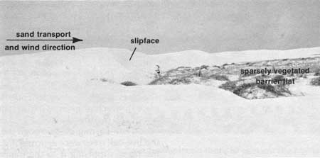
BACK-ISLAND DUNES (Observation Point 6). On the left side of the road, large dunes (fig. 120), part of a back-island dune field (B10), may be observed. The largest, elongate dunes, with heights up to about l5 feet in this area (up to 25 feet in some other areas), are oriented in an east-west direction. When the photograph in figure 120 was taken, this dune was being shaped by the dominant southeasterly winds and was migrating northward toward the road (to the right in the photograph). However, the dune sand is blown toward the south during winter by strong north winds. The steepest face of the dune is the slipface, which maintains a slope of about 30° as the dune migrates downwind. Migration takes place when sand blown to the top of the dune slides down and adds to the slipface. Crossbedding resulting from this periodic addition of sand to the slipface may be later partially eroded and exposed in the deflation flat after the dune passes (fig. 59a and b). Refer to the Internal Structure of Dunes discussion (p. 33) in the section on The Dynamic Barrier Island for a more detailed explanation of processes involved in dune and cross-bedding formation.
| ||||
| 0.7 | 4.6 |
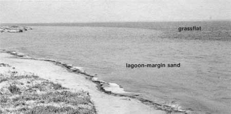
LAGUNA MADRE (Observation Point 7). Continue to the shore of Laguna Madre. Most of the broad, flat, barren areas at the edge of the island are wind-tidal flats covered with firm sand and mud (L2). These areas are flooded occasionally during high tides that are created by wind pushing lagoonal water into the back-island areas. The sand belt exposed at the lagoon "beach" and submerged adjacent to it is called lagoon-margin sand (L5) (fig. 121). Sand waves and ripples commonly form in this shallow (less than 3 feet deep) environment by lagoonal current and wave action. Beyond the lagoon-margin sand are grassflats (L6), which constitute the darker subaqueous areas visible in figure 121. The grassflats are sites of high biologic productivity, serving as habitats for a variety of invertebrates and as nurseries or spawning grounds for many fish and crustaceans.
This trip has provided a look at characteristic environments from the Gulf beach to the lagoon shoreline and grassflats. Environments observed include (1) beach and coppice dunes, (2) fore-island dune ridge, (3) stabilized blowout dunes and vegetated barrier flat, (4) wind-deflation trough or flat, (5) back-island dune field, (6) wind-tidal flat, (7) lagoon-margin sand, and (8) subaqueous grassflats. The island cross section (fig. 2) illustrates the locations of these environments. | ||||
| <<< Previous | <<< Contents >>> | Next >>> |
state/tx/1980-17/sec7.htm
Last Updated: 28-Mar-2007


