The following road log is a guide to important
geologic features that can be seen from Skyline Drive in the Shenandoah
National Park. The log is keyed to the numbered mileposts along Skyline
Drive. It begins at the north entrance to the park, at the intersection
of U. S. Highway 340 and Skyline Drive (mile 0.0) near the southern
corporate limit of Front Royal, and continues to the south for 105.2
miles (169.3 km). Places of special interest geologically are marked
with an asterisk.
Most of the geologic features can be seen from or
near overlooks that provide room for safe parking, or are located in
areas where Skyline Drive has wide shoulders on which parking is safe in
dry weather. When parking along Skyline Drive, be sure to pull
completely off the pavement and do not block fire roads or the entrance
to overlooks or other facilities. Rock samples may not be collected
or removed from Shenandoah National Park in accordance with National
Park Service regulations.
| Cumulative |
|
| miles | (km) |
Explanation |
| 0.0 | (0.0) | Enter Skyline Drive from U. S. Highway 340
near southern corporate limit of Front Royal. At this location the drive
is on Ordovician limestone and dolomite of the Rockdale Run Formation of
the Beekmantown Group, which is obscured by rock debris from the
Catoctin Formation. |
| 0.5 | (0.8) | Park Entrance Station. Skyline Drive
crosses the Front Royal fault that separates the Rockdale Run and
Catoctin formations. |
| 1.4 | (2.3) | Massive, purplish brown weathering, locally
vesicular, northwestward-dipping basalt flow of the Catoctin Formation
exposed along northbound lane. Brecciated basalt with epidote cement
visible at north end of exposure. |
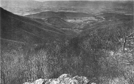
| 2.0 | (3.2) | Shenandoah Valley Overlook at milepost 2.
View of the Front Royal area and the north end of Massanutten Mountain. |
| 3.9 | (6.3) | Basalt of the Catoctin Formation exposed by
the northbound lane from this point to mileage 4.3 (km 6.9). |
| 4.7 | (7.6) | Entrance to Dickey Ridge Visitor Center and
Picnic Grounds. |
| 5.2 | (8.4) | Parking overlook by southbound lane
opposite locally epidotized basalt in roadcut. Zone of weathered-out
vesicles visible near top of exposure. |
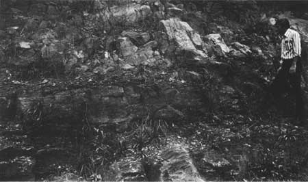
| *5.7 | (9.2) | Signal Knob Overlook. To the west, meander
loops of the South Fork of the Shenandoah River are visible near the
west side of the valley. In the background is Massanutten Mountain on
which several talus deposits have been formed from blocks of Silurian
Massanutten Sandstone that have moved downslope from the mountain crest.
In the roadcut to the east is one of the best exposures along Skyline
Drive of a boundary between basalt flows and the sedimentary rocks
commonly found in the Catoctin Formation (Figure 38). |
|
|
Figure 38. Catoctin Formation at Signal Knob Overlook
consisting of a thin, dark-red arkosic sandstone overlying a dark,
dense, partially epidotized, vesicular basalt and underlying a
lighter-hued basalt flow with columnar jointing. The dark iron-red
coloration of the sedimentary layer is probably due to mineralization
and "baking" by the overlying lava flow.
|
|
| *6.9 | (11.1) | Gooney Run Overlook. The boundary between
the Catoctin and Pedlar formations, a profound unconformity between the
late Precambrian volcanics and the porphyritic granodiorite of an
earlier Precambrian pluton, passes beneath the parking area (not to the
west of the overlook as is incorrectly shown on Plate 1). Purple
pyroclastic phyllite and pale-green rhyolitic (?) tuffs of the basal
Catoctin Formation are exposed between weathered basalt beds in the
roadcut. A good exposure of the Pedlar granodiorite
occurs 200 feet (61 m) west of the overlook at the
end of the footpath. |
| 7.3 | (11.7) | Gooney Manor Overlook. Browntown Valley to
the southwest and the low hills to the west are underlain entirely by
rocks of the Pedlar Formation. The main body of the Blue Ridge encircles
the valley to the north, east, and south, with most of the visible crest
capped by Catoctin basalt. |
| 9.2 | (14.8) | Lands Run Gap. Here the road crosses a
small concealed linear fault or flexure that separates the Catoctin
Formation from granodiorite of the Pedlar Formation. Traces of rocks
similar to those found in the Swift Run Formation and of epidotized
granodiorite that commonly occur below the Catoctin Formation at the
Precambrian unconformity are present along this linear depression. This
association suggests that this boundary is an exposure of the
unconformity along a vertical fold limb and probably not a fault as
shown on Plate 1. |
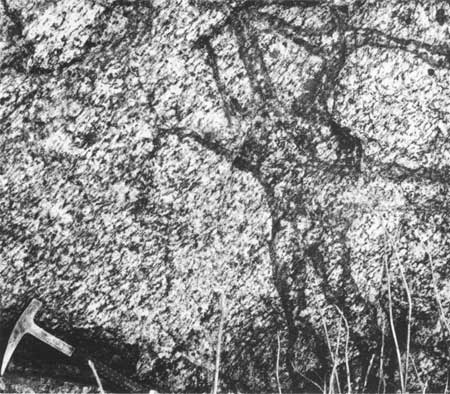
| *9.5 | (15.3) | Pull off on shoulder by southbound lane.
Exposures 300 feet (91 m) upgrade to south are migmatitic, granitic
gneiss of the Pedlar Formation (Figure 11). Light and dark layers in the
gneiss define plunging folds. Massive hypersthene granodiorite is
present on the crest of the ridge above the exposures, and it may have
been intruded into the gneiss exposed here. |
| *10.1 | (16.3) | For several hundred feet south and north of the sharp
bend in Skyline Drive a series of near vertical diabasic dikes, each
several tens of feet thick, extend across the road and are exposed in
the roadcuts. These and similar dikes in the plutonic rocks of the Blue
Ridge represent conduits through which the basaltic magmas of the
Catoctin Formation were extruded. The dikes are very dark green, fine
grained and porphyritic, and contain fragments and a few large blocks of
epidotized granodiorite. Where contacts of dikes with the wall rock are
visible, the Pedlar granodiorite is moderately epidotized or
unakitic. |
| 10.5 | (16.9) | Pyroclastic mud flows at the base of the
Catoctin Formation are exposed for several hundred feet up the slope
above the southbound lane. These rocks are shown as the Swift Run
Formation on Plate 1, but are not typical of that unit and possibly
should be placed within the Catoctin Formation. |
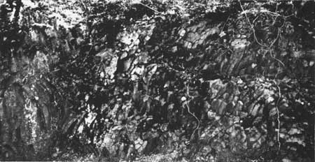
| *10.7 | (17.2) |
Indian Run Overlook. The basal basalt flow of the Catoctin Formation is
exposed in the roadcut by the overlook. The best display of columnar
jointing along Skyline Drive can be seen at the north end of this
exposure (Figure 39). |
|
|
Figure 39. Columnar basalt of the Catoctin Formation in the roadcut at
the north end of Indian Run Overlook. Locally, the subparallel columns
fan upward from high-temperature areas that existed in the flow during
solidification.
|
|
| The terrane to the east and north is underlain by
rocks of the Pedlar Formation capped, at the higher elevations, by thin
remnants of the basal Catoctin basalt flows, possibly the same flows
that are exposed in the roadcut. |
| 11.2 | (18.0) | Small exposures of the Swift Run
Formation occur along the southbound lane of Skyline Drive. The road
continues to the south on the Pedlar Formation for the next 3.1 miles
(5.0 km). |
| 12.4 | (20.0) | Jenkins Gap Overlook. A view of the
terrane developed on crystalline igneous rocks east of the Blue Ridge
crest. |
| *13.8 | (22.2) | Hogwallow Flats Overlook. This overlook
provides a good view of the foothills formed by the plutonic rocks along
the east side of the Blue Ridge mountains. Visible on very clear days,
about 20 miles (32 km) to the east, are low ridges formed by rocks of
the Catoctin Formation and the Chilhowee Group along the east flank of
the Blue Ridge anticlinorium in Fauquier County. |
| 14.3 | (23.0) | The contact between the Pedlar and
Catoctin formations extends across Skyline Drive just south of the
Appalachian Trail crossing. The drive is on the Catoctin Formation for
the next 6.7 miles (10.8 km). |
| 14.9 | (24.0) | Browntown Valley Overlook. At this
overlook, and for nearly a mile to the south, Skyline Drive is
constructed on a natural bench developed on the upper part of a
Catoctin basalt flow, one of the 13 flow benches that can be seen along
the west face of Mount Marshall (Figure 13). Across Browntown Valley and
the low hills that separate it from the Shenandoah Valley, both crests
of Massanutten Mountain are visible on clear days, as well as part of
Great North Mountain, the next major ridge west of the Massanutten
mountain range. These ridge crests mark the outcrop of steeply dipping
quartzite beds of Silurian age. |
| *17.2 | (27.7) | Range View Overlook. This overlook provides a rare,
panoramic view of the Blue Ridge to the south and of the mountains and
ridges to the east and west of it. From this location it can be seen
that the shape, elevation, and linear extent of the ridges of the
Piedmont province east of the Blue Ridge contrast strongly with those of
the Valley and Ridge province to the west. The eastern ridges and hills
of the Piedmont, formed on the massive plutonic rocks in the core of the
Blue Ridge anticlinorium, vary in shape and elevation from ridge to
ridge. These hills are of limited linear extent although they are
generally aligned with their long axes parallel to the prevailing
northeastward trend of the Blue Ridge mountains. The Massanutten
mountain range and other ridges to the west in the Valley and Ridge are
linear, and have relatively uniform shape and crestal elevations for
long distances along their northeasterly trend. The differing morphology
of the mountains in the Piedmont and Valley and Ridge is a reflection of
the bedrock and structure. The hills to the east are formed by
homogeneous intrusive and metamorphic rocks that are fractured and
sheared along lines parallel to the Blue Ridge, and randomly
crisscrossed by faults, joints, and dikes. In this area weathering and
mass wasting is more rapid along the zones of fracture and the linear
intrusive bodies, and has produced discontinuous linear lows that bound
the irregularly shaped hills and ridges formed on the less intensely
fractured plutonic rock. |
| To the west the rocks of the Valley and Ridge are
stratified, heterogeneous, and tilted with the thicker, inclined,
resistant rocks forming the long, parallel, even crested ridges typified
by Massanutten Mountain. Fault and joint systems also modify the rates
of weathering and mass wasting of the stratified rocks producing gaps
and saddles, but do not mask the dominating influence of the stratified
sequence in controlling the characteristic shape and extent of the
resistant ridges. |
| 18.4 | (29.6) | Gimlet Ridge Overlook. Another good view
of Browntown Valley and the ridges to the northwest. Distant rock
exposures on the steep slopes to the west are of the Pedlar Formation. The
steep, narrow, closely spaced hollows along the escarpment are
characteristically formed on the plutonic rocks on steep slopes below
the contact with the Catoctin Formation. |
| 19.0 | (30.6) | Mount Marshall Overlook at milepost 19. A
series of low gaps between the main Blue Ridge mass and the several
southeastward-trending subsidiary ridges mark the location of a fault
zone that separates the Catoctin Formation from the Pedlar Formation to
the east. Massive basalts exposed north of the overlook have coarse
columnar jointing. |
| 19.3 | (31.1) | Skyline Drive crosses a small vertical
fault within the Catoctin Formation. Near the road the fault is not
exposed, but a zone of angular basalt rubble appears to define its trace
across the mountain crest. |
| 19.7 | (31.7) | Little Hog Back Overlook. To the west the
very steep slope is underlain by the Pedlar Formation and is typical of
slopes developed on this unit at higher elevations where the Catoctin
Formation overlies it or has overlain it in the recent geologic past.
The unconformity between the Catoctin and Pedlar formations passes
beneath the eastern part of this overlook, with no evidence for the
presence of the Swift Run Formation. |
| *20.1 | (32.3) | Little Devil Stairs Overlook. The deep, steeply
inclined gorge (Little Devil Stairs) to the south is formed in the
Catoctin Formation along a northward-trending zone of fractures. Several
northward-trending Catoctin feeder dikes at the head of the gorge are
exposed in the roadcut at milepost 20 just north of the overlook, and
may have influenced the development of Little Devil Stairs, if they
penetrated the lower Catoctin basalt flows. |
| Dark, coarse-grained granodiorite of the Pedlar Formation,
much of which is unweathered, is well exposed adjacent to the
overlook and to the north. Penetrating, dark-red iron stains, thought to
be paleoweathering features preserved from late Precambrian time, are
well displayed in both the fresh and weathered rock (see description for
Hogback Overlook, milepost 21). |
| *21.0 | (33.8) | Hogback Overlook at milepost 21. Due to the removal of the Catoctin
Formation by erosion in the recent geologic past, the crest of Hog Back
Mountain is now underlain by the Pedlar Formation. The contact between
the two rock units was little more than 100 foot (30 m) above the
present crest, indicating that the rocks now exposed at the overlook
were probably subjected to weathering prior to the extrusion of the
Catoctin basalt flows in late Precambrian time. Dark-red iron stains
that penetrate the granodiorite along incipient fractures are suggestive
of ancient weathering features, as other generally open fractures in
the same rock exhibit the typical brown iron-oxide-staining characteristics
of recent weathering. These features can be seen in the rock
exposures at the overlook near road level (Figure 40). |
|
|
Figure 40. Granodiorite of the Pedlar Formation on
the south side of Skyline Drive at Hogback Overlook, 0.2 mile (0.3 km)
south of milepost 21 (Plate 1). The granodiorite is a light-gray,
porphyritic, moderately foliated crystalline rock. The rocks exposed
here were probably less than 100 feet (30 m) below the Precambrian
erosion surface. The intersecting arm-like forms in the rock are purple,
penetrative, iron-oxide stains along ancient healed fractures. The
stains probably relate to mineralization during Catoctin volcanism or to
weathering before the lavas covered the Precambrian surface.
|
|
| The view to the north from Hogback Overlook is the
best in the northern section of the park. It encompasses much of the
northernmost protuberance of the Blue Ridge into Shenandoah Valley. This
area, underlain by Cambrian and Precambrian rocks, has been thrust
several miles westward over the younger Cambrian and Ordovician
carbonates. Browntown Valley, a portion of the protuberance is in the
foreground with the Blue Ridge escarpment and Mount Marshall to the
northeast. |
| 21.3 | (34.3) | The contact between the Catoctin and
Pedlar formations extends across Skyline Drive at this point, but no
evidence of the Swift Run Formation is visible. |
| 21.8 | (35.1) | Rattlesnake Point Overlook. A view of the
eastern Blue Ridge mountains and the southeast foothills. Fine vesicular
basalts are exposed in the roadcut at the north end of the overlook. |
| 22.2 | (35.7) | Entrance to Matthews Arm Campground. |
| 24.0 | (38.6) | Entrance to Elkwallow Wayside at milepost 24. |
| 24.2 | (39.0) | Entrance to Elkwallow Picnic Grounds. |
| 25.0 | (40.2) | The base of the Weverton Formation between mileposts 25 and 26 parallels
Skyline Drive just above road level, and basalts or purple slate are
exposed locally in the roadcut. |
| 26.4 | (42.5) | Jeremys Run Overlook. Jeremys Run drains
a large, steep area underlain largely by the Catoctin Formation with
caps of the Weverton and Hampton formations on the higher surrounding
ridges. To the west, parts of Shenandoah Valley can be seen, with New
Market Gap in the Massanutten Mountain area visible in the distance. |
| 26.9 | (43.3) | Jointed sandstone beds of the lower part
of the Weverton Formation with well-developed spheriodal weathering are
exposed by the southbound lane. |
| *27.1 | (43.6) | Contact between the Catoctin and
Weverton formations exposed above the southbound lane. Vesicular basalt
of the Catoctin Formation is directly overlain by a conglomerate of
angular basalt fragments and rounded quartz pebbles that comprise the
base of the Weverton Formation at this location. |
| 27.6 | (44.4) | Thornton Hollow Overlook. A view to the
east and north of the Blue Ridge foothills and the Elkwallow area,
respectively. Massive basalts of the Catoctin Formation in
the roadcut by the overlook are cut through with slickenside
surfaces on which fibrous anthophyllite (a variety of asbestos) is
preserved. |
| 28.4 | (45.7) | Beahms Gap Overlook on west side of Skyline drive, with a
few large blocks of epidotized basalt breccia from the Catoctin
Formation near the north entrance to the overlook. |
| 29.5 | (47.5) | On east side of Skyline Drive is an exposure of a
massive, slightly vesicular purple basalt. |
| 30.1 | (48.4) | Pass Mountain Overlook. View of Luray area in
Shenandoah Valley and New Market Gap in Massanutten Mountain to the west. The
westernmost ridges of the Blue Ridge mountains are underlain by steeply
dipping quartzite beds of the Chilhowee Group (the Weverton, Hampton,
and Erwin formations). |
| 31.4 | (50.5) | Exit to U. S. Highway 211 at Thornton Gap. |
| 31.5 | (50.7) | Entrance to Panorama (restaurant and service station).
A major geologic structure, the Stanley fault, passes from east to
west through Thornton Gap and separates the Catoctin Formation (on the
north) from the Pedlar Formation (on the south). |
| 32.0 | (51.5) | Exposures at milepost 32 of the Pedlar Formation occur
intermittently along Skyline Drive for next 7.1 miles
(11.4 km). |
| 32.2 | (51.8) | Marys Rock Tunnel. Excellent exposure of a Catoctin
feeder dike on west side of north portal. Do not attempt
to park here. |
| *32.4 | (52.1) | Tunnel Parking Overlook. Park here and
walk through tunnel to examine Catoctin feeder dike at mileage 32.2.
View to the east of exposures of Old Rag Granite on Oventop Mountain in
distance. Exposures on the west side of Skyline Drive are of very
strongly foliated granodiorite typical of the Pedlar Formation in this
part of the park. Foliation is so well developed that the rocks have a
stratified appearance in these exposures. |
| *32.8 | (52.8) | Buck Hollow Overlook. Excellent exposures in roadcut
of strongly foliated Pedlar granodiorite with 2- to 3-inch (5- to 7-cm)
long lenses of garnet-bearing felsic material. To the north in the
extreme distance along the lower slopes of the Blue Ridge, two widely
separated bedrock exposures visible on a clear day mark the locations of
Little Devil Stairs to the west and Big Devil Stairs to the east, steep
gorge-like features formed along northward-trending fracture zones in
the Catoctin Formation. |
| 33.1 | (53.3) | Hazel Mountain Overlook. Additional
exposures of the Pedlar granodiorite. |
| 35.1 | (56.5) | Pinnacles Overlook. View to the south of
the north face of Old Rag Mountain with Corbin and Robertson mountains
to the south and west, respectively, all areas underlain by the Old Rag
Granite. Several exposures of the Pedlar Formation are present at the
overlook. |
| 36.4 | (58.6) | Jewell Hollow Overlook. View to the
northwest of sharp-crested ridges formed on rocks of the Chilhowee
Group near Shenandoah National Park Headquarters. |
| 36.7 | (59.1) | Entrance to Pinnacle Picnic Grounds. |
| 38.6 | (62.1) | Stony Man Overlook (Hughes River Gap).
Exposures in roadcut of light-hued, fine-grained Pedlar granodiorite.
The view to the west is of Luray and of Page Valley, that segment of
Shenandoah Valley between Stanley and Luray which is underlain by
Cambrain and Ordovician carbonates and shales. To the south, the profile
of Stony Man is outlined in outcrops of columnar basalts of the Catoctin
Formation. |
| 39.1 | (63.0) | Trail Parking Area. The concealed contact
between the Pedlar and Catoctin formations is less than 100 feet (30 m)
to the north. Excellent exposures of the Catoctin Formation along Stony
Man Trail and for the next 0.7 mile (1.1 km) along Skyline Drive.
Differentially epidotized columnar basalts are best displayed near the
parking area along this section. To the north the Pedlar Formation
exhibits the rectilinear, red iron stain patterns characteristically
present in the plutonic rocks just below the Catoctin contact, and are
thought to be the result of Precambrian weathering or the introduction
of mineralizing fluids during Catoctin volcanism. |
| 39.8 | (64.0) | Hemlock Springs Overlook. A view to the
north of the plutonic-rock terrane in the Pinnacles area. The hollow at
the south end of the overlook is typical of the debris-filled hollows
formed on the Catoctin Formation. |
| *40.6 | (65.3) | Thorofare Mountain Overlook. The best
view of Old Rag Mountain from Skyline Drive. Late afternoon lighting
accentuates the northward-trending joint system visible on the north
face of the mountain (Figure 41). |
|
|
Figure 41. North face of Old Rag Mountain, with late afternoon light
accentuating the north-trending fracture system in the granitic rocks.
These joints roughly parallel the trend of the Catoctin feeder dikes
exposed along the crest and may have formed during Catoctin
volcanism.
|
|
| 41.1 | (66.1) | Along the north side of Skyline Drive
boulder fields and talus deposits of basalt debris lie on gently
southeastward-dipping, differentially epidotized basalt flows of the
Catoctin Formation for the next 0.4 mile (0.6 km). |
| 41.7 | (67.1) | North entrance to Skyland (highest elevation on
Skyline Drive). In the Skyland area to the west more than 200 feet (61
m) of Swift Run sedimentary rocks separate Pedlar granodiorite from the
lower basalt flows of the Catoctin Formation. The Swift Run Formation is
exposed downslope (west) from Skyland restaurant and in a small quarry
north of the stables. It is a stratified sequence of phyllite and
coarse, pebbly sandstone of both pyroclastic and detrital origin. The
restaurant and upper cabin area is on strongly cleaved basalts and the
lower cabin area mostly on very dark-gray, gneissic granodiorite. All of
Page Valley and most of Massanutten Mountain are visible from the
Skyland area on clear days. |
| 42.5 | (68.4) | South entrance to Skyland. The contact between the
Catoctin and Swift Run formations extends across Skyland
Drive at this entrance and passes through the White Oak
Canyon parking area to the east. |
| 42.7 | (68.7) | Approximate location of contact between the Swift Run
and Pedlar formations. |
| *43.3 | (69.7) | Timber Hollow Overlook. View to the west
of Page Valley and of Hershberger Ridge beyond the small community of
Ida at the west foot of the Blue Ridge. Hershberger Ridge is formed by
rocks of the Erwin Formation and appears to be bounded by faults on the
southeast and northwest. Just west of the overlook are exposures of
Pedlar granodiorite cut by veins of epidote that may be the result
of mineralization associated with the early Catoctin basalt flows. |
| 43.8 | (70.5) | Approximate location of the concealed
Swift Run Formation. Skyline Drive passes onto the Catoctin Formation
to the southeast. |
| 44.3 | (71.3) | Crescent Rock Overlook. View of
Hawksbill Mountain to the southwest, the highest peak in the park,
with several cliffs of columnar basalt visible on the northwest
face (Figures 4, 42). |
|
|
Figure 42. View from Crescent Rock Overlook west toward the small
community of Ida at the mouth of Timber Hollow. The ridges just
beyond the community mark the location of a narrow, folded belt of
Catoctin and Chilhowee rocks that are apparently bounded by faults
along the east and west foot of the ridges. Beyond these ridges
is Page Valley, a segment of Shenandoah Valley that is floored by
Cambrian and Ordovician carbonate rocks. Beyond the valley is the
Massanutten mountain range and New Market Gap (upper left) that
provides access between Page Valley and the northwestern part of
Shenandoah Valley.
|
|
| 45.3 | (72.9) | Exposures by southbound lane of gently
southeastward dipping, amygduloidal basalt with veins of epidote and
jasper. These rocks are characteristic of the upper few feet of many
Catoctin basalt flows. |
| 45.7 | (73.5) | Hawksbill Trail parking area. |
| 46.5 | (74.8) | Old Rag View Overlook. Profile of the
steep north face of Old Rag Mountain. |
| 46.6 | (75.0) | Upper Hawksbill parking area. |
| 47.2 | (76.0) | In curve on northeast side of Skyline
Drive are exposures of Catoctin basalt in which small sedimentary dikes
formed while the flow was cooling and possibly still mobile. The
sediments are very fine-grained, yellow to purple, exhibit
pseudo-bedding features, and were probably injected as a fluid mass into
fractures at the base of the flow as it advanced across unconsolidated
sediments. |
| 47.8 | (77.0) | Approximate location of the contact between the Catoctin
and Pedlar formations; no evidence of the Swift Run
Formation was found in this area. |
| *48.1 | (77.4) | Spitler Knoll Overlook on rocks of the Pedlar
Formation. A view to the northwest of Page Valley, the town of
Stanley, and New Market Gap in Massanutten Mountain.
The sharp-crested peaks and ridges to the west comprise
the northern part of an uplifted mass of Precambrian and
Early Cambrian clastic rocks that extends lobe-like out
into the valley. It is separated from later Cambrian and
Ordovician carbonate rocks of Page Valley by the Stanley
fault that passes between Stanley and the northern line
of ridges. |
| 48.3 | (77.8) | Approximate location of the contact
between the Pedlar and Catoctin formations, with the Catoctin present to
the south. |
| 49.0 | (78.8) | Franklin Cliff Overlook at milepost 49.
Several thick epidotized basalt flows form Franklin Cliffs, and
remnants of an epidotized basalt breccia that marks the top of the upper
flow are preserved in the wooded area between the cliffs and Skyline
Drive at the north end of the overlook. To the west the low farmlands
along the base of the Blue Ridge are covered by alluvial fans and
terraces formed from resistant rock debris derived from the Blue Ridge
and transported into the valley. These clay, sand, and boulder deposits
conceal bedrock along a belt 1 to 3 miles (2 to 5 km) wide at the west
foot of the Blue Ridge for many miles. |
| 49.4 | (79.5) | Fishers Gap Overlook. |
| 50.6 | (81.4) | Dark Hollow Falls parking area. The trail
leads downhill for several thousand feet to Dark Hollow Falls
(Frontispiece) where the surface drainage from much of the Big Meadows area
tumbles over a series of small benches formed on a resistant basalt
flow. Amygdaloidal and porphyritic basalts are well exposed along the
stream above the falls (Figure 43). |

|
|
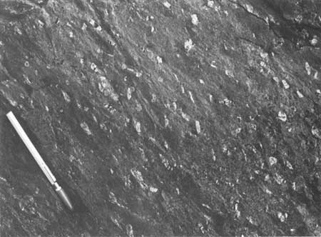
Figure 43. Amygdaloidal metabasalt with the amygdules
weathered out in relief along the trail to Dark Hollow Falls from Dark
Hollow Falls parking area.
|
|
| 50.8 | (81.7) | Entrance to Byrd Visitor Center. |
| 51.0 | (82.1) | Big Meadows marshy grassland at milepost 51 on south
side of Skyline Drive. |
| *51.2 | (82.4) | Entrance to Big Meadows lodge, restaurant, and camp
grounds. The view from Blackrock of the trail west of Big Meadows Lodge
is a panorama of Page Valley and the Blue Ridge escarpment north of Big
Meadows. This is one of the few points from which many of the major
structural elements of this area may be seen. The approximate trace of
the Stanley fault can be followed to the east where it turns northeast
through the valley at the foot of the Blue Ridge escarpment. Beyond the
escarpment it turns to the east again, and extends across the Blue Ridge
at Thornton Gap. |
| To the west and north the straight, even crests of
the paralleling ridges of Massanutten Mountain contrast sharply with the
irregular, lobate front of the Blue Ridge, and attest to the greater
structural complexity of the rock strata in the Blue Ridge. |
| *51.5 | (82.9) | Tanners Ridge Overlook. The ridges
bounding the westward bulge of the Blue Ridge on the northwest and
southwest are formed by steeply tilted, resistant quartzites of the
Erwin (Antietam) Formation. |
| 53.4 | (86.0) | Naked Creek Overlook. A westward view across Long
Ridge capped by the Weverton Formation. Much of the
mountainous area to the west is underlain by the Catoctin,
Swift Run, and Pedlar formations except at the base of
the western (Erwin) ridges where the Chilhowee Group
lies directly on the Pedlar Formation. |
| *54.8 | (88.2) | Hazeltop Ridge Overlook. A broad extension of
Shenandoah National Park protrudes westward almost to the South Fork of
the Shenandoah River. At milepost 55, just south of the overlook on the
east side of Skyline Drive, are exposures of Catoctin basalts with
epidosite lenses, wavy cleavage surfaces, and slickensides with
chatter-marked surfaces. |
| 55.6 | (89.5) | The Point Overlook. Panorama from the
western ridges to the southwest to Tanners Ridge and Blackrock to the
north. Intensely sheared Catoctin basalt flows and volcanic tuff beds
can be seen in the roadcut on the east side of Skyline Drive. |
| 56.4 | (90.8) | Bearfence Mountain Parking Area. Less
than 200 feet (61 m) east along the trail to Bearfence Mountain, ledges
of coarse-grained, very quartzose, cross-laminated sandstones of the
Swift Run Formation are exposed in the nose of a northeastward-plunging,
overturned anticline. These sandstones exhibit better sorting and
rounding of the sand grains than most exposures of Swift Run clastics.
Skyline Drive crisscrosses the thin, poorly exposed Swift Run Formation
several times in the next 2 miles (3 km) to the south. |
| 57.5 | (92.5) | Entrance to Lewis Mountain Campground. Vertical sandstones
of the Swift Run Formation are exposed in the northern part of the
campground and to the north. |
| 59.1 | (95.1) | Oaks Overlook. |
| 61.3 | (98.6) | Baldface Mountain Overlook. The town in the distance is
Shenandoah, built mostly on terrace-gravel deposits that cover
Ordovician limestones and dolomites. |
| 62.7 | (100.9) | South River Overlook and entrance to South River picnic
grounds. View down South River gorge between two mountains of Catoctin
basalt. |
| *64.4 | (103.6) | Hensley Hollow Overlook. Good exposures of the Swift
Run Formation in the roadcut. The formation as exposed here is mostly
phyllite with some beds containing dispersed pebbles and cobbles of
granitic rock, vein quartz, and phyllite clasts. Skyline Drive crosses
the contact between the Swift Run and Pedlar formations several times to
the south between here and Swift Run Gap. |
| Beyond Hensley Ridge to the northwest, Elkton is
visible at the west end of a linear fault segment that separates
quartzites and phyllites of the Chilhowee Group to the south from the
Cambrian carbonates of the Shenandoah Valley to the north (Plate
2). |
| 65.5 | (105.4) | Swift Run Gap and junction of Skyline
Drive with U. S. Highway 33. The Swift Run Formation was named and
described from exposures about a mile east of Skyline Drive along an
abandoned road above U. S. Highway 33. The gap is underlain by
granodiorite of the Pedlar Formation, which is exposed intermittently
along the drive for the next 4.5 miles (7.2 km). |
| 67.2 | (108.1) | Swift Run Overlook. Pedlar granodiorite exposed in
the roadcut and overlook is porphyritic, coarse-grained, locally
epidotized, and jointing is well developed. Exposures of Catoctin
basalts can be seen high on the ridge to the east. |
| *67.8 | (109.1) | Sandy Bottom Overlook. Massive exposures of Pedlar
granodiorite in the roadcut to the east. The panoramic view to the west
includes sharp-crested phyllite and quartzite ridges of the western part
of the Blue Ridge and the south peak of Massanutten Mountain in the
distance. South of the overlook the park terrane west of Skyline Drive
is dominated by ridges formed by rocks of the Chilhowee Group. |
| 68.5 | (110.2) | Smith Roach Gap. The Catoctin Formation caps the
Pedlar granodiorite in the gap and on adjacent ridges. |
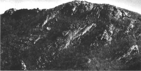
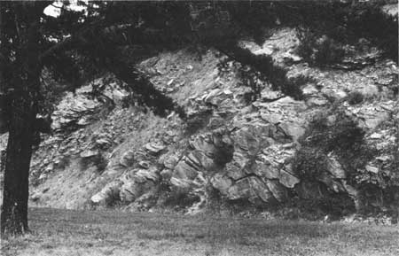
| *69.3 | (111.5) | Bacon Hollow Overlook. The strongly foliated Pedlar
granodiorite exposed in and near the overlook is typical of the rocks
that underlie Bacon Hollow to the east. This spectacularly deep U-shaped
hollow exemplifies the rapid weathering and disintegration of the Pedlar
Formation that takes place after the removal of the protecting cap of
resistant Catoctin basalt flows. Basalt cliffs rim the northern
escarpment above cliffs developed in the granodiorite (Figure
2). The mountain to the south is capped by a much
thicker remnant of the basalts, and the escarpment below them is not as
well developed. |
| Several small copper mines were opened in the lowest
Catoctin basalt flow along the northern escarpment in the early
twentieth century. Small quantities of native copper, malachite,
cuprite, bornite, and chalcopyrite have been found in epidotized
portions of the lower basalt flows. |
| *70.1 | (112.8) | The Swift Run Formation, comprised of pebbly and
sandy phyllites, is well exposed in the deep roadcut. The well-formed
cleavage surfaces transverse to bedding have been flexed by a second
cleavage parallel to the bedding, possibly indicating two periods of
deformation. |
| 70.6 | (113.6) | Eaton Hollow Overlook. Good view 10
miles (16 km) to the north, where the lower Cambrian clastic rocks and
Precambrian volcanic and plutonic rocks form a westward protuberence of
ridges into the Shenandoah Valley. |
| 71.2 | (114.6) | Rocky Mount Overlook. A closer view of
Rocky Mount, a ridge and talus deposit formed by the quartzites of the
Erwin Formation (Figure 25). The low ridge and hollow east of Rocky
Mount are underlain by phyllites and non-resistant metasandstones of the
Harpers and Weverton formations. Strongly jointed basalt is exposed in
the road cut opposite the overlook. |
| 72.3 | (116.3) | Beldore Hollow Overlook. View to the
west of a broad expanse underlain by the Hampton Formation, the
phyllitic middle portion of the Chilhowee Group. Massive epidotized
basalts of the Catoctin Formation are exposed in the roadcut. |
| 74.5 | (119.9) | Loft Mountain Overlook. Dense, purple,
slightly vesicular Catoctin basalts are exposed in the roadcut and on
the overlook. Basalt-capped mountains to the east (Flat Top Mountain)
and southwest (Loft Mountain) flank a boulder filled valley cut by Ivy
Creek down into the Pedlar granodiorite. |
| 75.3 | (121.2) | Pinefield Gap. Approximate location of
the contact between the Catoctin and Weverton formations, with the
Weverton poorly exposed on the west. |
| 75.4 | (121.3) | Approximate location of the concealed
contact between the Weverton and Hampton formations. Phyllites and
metasandstones of the Hampton Formation are exposed intermittently from
here to Twomile Run Overlook. |
| *76.2 | (122.6) | Twomile Run Overlook. View to the
west between Rocky Mountain and Rocky Mount, aptly named ridges capped
by folded white Erwin quartzite strata and sheathed in
quartzite talus. The sinuous, sharp-crested ridges and steep V-shaped
hollows leading out from Skyline Drive to the north are typical
landforms developed on incompetent metasandstone and phyllite of the
Hampton Formation. To the northwest the resistant Erwin quartzite
strata outline a syncline-anitcline fold-pair in the ridge top
silhouetted against Shenandoah Valley and Massanutten Mountain (Figure
27). |
| 76.9 | (123.7) | Brown Mountain Overlook. View to the
west into the Big Run drainage basin and southeast slope of Rocky
Mountain. Folded, westward-dipping fine-grained metasandstone,
phyllite, and coarse-grained quartzite of the Hampton Formation is exposed
in the roadcut. |
| 77.6 | (124.9) | Ivy Creek Overlook. A view of Loft
Mountain and the upper reaches of Ivy Creek gorge. In winter and early
spring, quartzite ledges in the Weverton Formation are discernable along
the low ridge east of Ivy Creek. |
| 77.8 | (125.2) | Good exposures of Hampton metasandstone
and phyllite in the roadcut with well-defined bedding and cleavage.
Cliffs of Weverton quartzite, in an overturned fold limb adjacent to its
contact with the Catoctin Formation, are visible to the south in the
upper (south) end of Ivy Creek gorge. |
| *78.1 | (125.7) | Rocky Top Overlook. View to the west into the Big Run
drainage basin, one of the largest drainage basins within the park. It
is rimmed to the west and north by ridges capped by generally
westward-dipping, but folded Erwin quartzite beds, and to the south and
east by high Hampton and Catoctin ridges in the Loft Mountain area.
Exposures of thick-bedded, phyllitic metasandstones and thin, interbedded
shales of the Hampton Formation are exposed in a westward-dipping
sequence in the roadcut by the overlook. |
| 78.4 | (126.1) | Cross-laminated, cross-grained quartzite of the Hampton
Formation is exposed by the northbound lane adjacent to talus formed
from the more common phyllites and metasandstones of that unit. |
| 79.0 | (127.1) | Exposure at milepost 79 of the lower phyllite member of the
Hampton Formation along the southbound lane. |
| *79.4 | (127.8) | Typical exposure of the lower Weverton Formation in
the roadcut. Coarse, arkosic metasandstone, quartzites, and interbedded
phyllite, all containing minor amounts of small quartz pebbles, are
present in a westward-dipping sequence immediately above the purple
slates that comprise the uppermost Catoctin Formation (not visible here).
Park in the wayside to the south. |
| *80.9 | (130.2) | Purple, porphyritic basalts of the Catoctin Formation crop out along the
northbound lane in one of the best exposures of this rock type in the
park (Figure 44). Park at Big Run Overlook to the south. |
|
|
Figure 44. Porphyritic basalt beds on the south side of Skyline Drive.
The dark, purplish-red metabasalts contain large crystals (phenocrysts)
of red-stained feldspar and locally provide recognizable horizons in
the metabasalt sequence.
|
|
| 79.5 | (128.0) | Entrance to Loft Mountain Campground on the east, and
wayside (service station and restaurant) on the west. |
| 81.0 | (130.3) | Exposures at milepost 81 along the
northbound lane of purple slate and arkosic metasandstone of the
Catoctin and Weverton formations, respectively, at the overturned
contact between the units. |
| *81.2 | (130.7) | Big Run Overlook. Northwest view of the Big Run
drainage area and the gap between the Erwin quartzite ridges through
which Big Run exits into Shenandoah Valley. Many of the better exposures
of the Erwin and Hampton formations in Shenandoah National Park are
present in this gap and upstream along Big Run. Pebbly, metasandstones
of the Weverton Formation are exposed in the roadcuts to the east. |
| 81.9 | (131.8) | Doyles River Overlook. Eastward view of the Browns Cove
drainage area formed on the Catoctin Formation and drained by Doyles
River and Jones Run, along which several waterfalls may be seen from
Falls Trail. |
| *82.3 | (132.4) | Appalachian Trail crossing. From here to Browns Gap
exposures along the southbound lane and along the Appalachian Trail to
north (Figure 19) are representative of most lithologies in the Weverton
Formation. Lenses of coarse grained, pebbly quartzite and laminated,
silvery-green phyllite represent the range of clastic sedimentary
strata exposed along Skyline Drive in this area. The lateral variation
in bedding thickness and rock type is indicative of the probable fluvial
origin of these sedimentary rocks. The Catoctin-Weverton contact,
although not exposed, is at road level in Browns Gap. |
| 83.7 | (134.7) | Dundo Overlook and entrance to Dundo Campground. A
broad expanse of gravel fans and terraces underlie the surface of the
Shenandoah Valley visible to the west through the gap at the mouth of
Dundo Hollow. |
| 84.1 | (135.3) | Falls Trail parking area on east. |
| *84.8 | (136.4) | Gated fire road on west side of Skyline Drive
provides hiking access to Blackrock, less than 0.5 mile (0.8 km) to
the southwest. A large outcrop of bluish-gray, cross-laminated quartzite
(Figure 21) within the Hampton Formation with an extensive talus deposit
(Figure 26) forms Blackrock. The view to the west of Trayfoot Mountain
includes several large but discontinuous talus deposits that were formed
from equally discontinuous lenses of quartzite that appear to be lateral
recurrences of the ledge-forming beds at Blackrock. |
| *86.8 | (139.7) | Trayfoot Mountain Overlook. A broad view to the south
of the crest of the Blue Ridge, with Trayfoot Mountain to the west and
Pasture Fence Mountain to the east. From Dundo south to Jarman Gap,
Skyline Drive follows the crest formed by rocks of the Hampton
Formation. The paralleling ridge to the east is underlain by the
Catoctin Formation that commonly forms higher crests than rocks of the
Hampton Formation. In this area, however, the Hampton strata are gently
inclined and only slightly folded, and include quartzite strata that
make the unit more resistant to erosion and therefore capable of forming
higher ridges. On and near Trayfoot Mountain the Hampton quartzites
reach their maximum thickness and account for the still higher elevation
of that ridge. |
| 87.1 | (140.1) | Appalachian Trail crosses Skyline Drive near exposure
of ferruginous metasandstones of the Hampton Formation in the roadcut
along the southbound lane. |
| 87.6 | (141.0) | Good view to northwest of the talus deposits formed by
erosion of the Hampton quartzites on Trayfoot Mountain. |
| *88.7 | (142.7) | Horsehead Overlook. View of Rocks Mountain to the
southwest, an Erwin quartzite-capped ridge, and talus deposits of
Hampton quartzite on the south end of Trayfoot Mountain. Exposures of
interbedded metastandstone and phyllite of the Hampton Formation in the
parking area have well-defined bedding and cleavage relationships that
indicate these strata are overturned to the northwest (Figure 45). |
|
|
Figure 45. Phyllite and thin interbedded metasandstone of the
Hampton (Harpers) Formation in the overturned limb of a fold at Horsehead
Mountain Overlook.
|
|
| 90.0 | (144.8) | Calvary Rocks parking area. The trail west from Skyline
Drive leads to Calvary Rocks, the nearest exposures of Erwin quartzites
to Skyline Drive (Figure 24). |
| *9.14 | (147.1) | Riprap Overlook. Turk Mountain, the high peak to the
southwest, is capped by Erwin quartzite that has been preserved in the
northeastern end of a southwestward-plunging syncline. To the west a
broad expanse of farm land in the Shenandoah Valley may be seen. Low,
forest-covered conical hills and linear, northeastward-trending ridges
in the valley are formed where concentrations of
chert or sandstone provide resistant zones in the Cambrian and
Ordovician limestone and dolomite sequence. |
| *92.0 | (148.0) | Moormans River Overlook. A view to the southeast
through a major gap in the ridges formed by basalt flows of the Catoctin
Formation. The lake, Moormans River Reservoir, a part of the
Charlottesville water supply system, is impounded on granitic rocks of
the Pedlar Formation where the Catoctin and Swift Run formations have
been breached by Moormans River. The northeastward-trending segment of
Moormans River occupies an extensive linear low within the Catoctin
Formation, and may follow the trace of a reverse fault extending from
the Loft Mountain area southwest through Jarman Gap. Additional
evidence for such a fault may be the intensely sheared basalts locally
exposed along this lineament. |
| 92.1 | (148.2) | Wildcat Ridge Overlook on west side of Skyline
Drive. |
| 92.7 | (149.2) | Crimora Lake Overlook. Westward view of an abandoned
manganese-mining operation. The ore was concentrated in the sandy-clay
residual material formed along the contact between the Erwin and
overlying Shady formations. |
| 93.7 | (150.8) | Turk Mountain Overlook on west side of Skyline
Drive. |
| 94.6 | (152.2) | Roadcut exposures of phyllite in the lower portion of
the Hampton Formation for next 0.3 miles (0.5 km). |
| 95.4 | (153.5) | Sawmill Run Overlook. View to the south
of the Blue Ridge crest formed by a folded sequence of basalts and
interbedded sedimentary and tuffaceous rocks of the Catoctin Formation.
Good exposures of folded quartzite beds in the Weverton Formation may be
seen along the Appalachian Trail near the crest of the pine-covered
ridge to the southeast. |
| 95.6 | (153.8) | Approximate contact between the Weverton
and Hampton formations; Weverton to the southeast. |
| *95.9 | (154.3) | Sawmill Ridge Overlook. Large lenses and
discontinuous beds of Weverton metastandstone and quartzite interbedded
with sericitic phyllite are displayed in roadcut. The upper part of an
overturned anticline is visible at road level adjacent to the overlook
(Figure 46). |
|
|
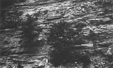
Figure 46. Crestal portion of an overturned anticline in the Weverton
Formation at Sawmill Ridge Overlook. Well-developed cleavage inclined to
the right (southeast) tends to obscure bedding features even in the
quartzites and competent metasandstones that are exposed here.
|
|
| 96.1 | (154.6) | Sandy phyllite in the base of the Weverton Formation
exposed along northbound lane. |
| 96.2 | (154.8) | Contact of the Weverton and Catoctin formations just north
of gas pipeline in gap. In this area discordant attitudes of beds across
the contact suggest the presence of a small
fault, an angular unconformity, or fluvial channels
cut in the surface of the Catoctin Formation and subsequently filled
with cross-laminated sediments that now comprise the base of the
Weverton Formation. |
| 96.3 | (154.9) | Epidotized metasandstones of Catoctin
Formation along the northbound lane trend obliquely into the contact
with sediments of the lower part of the Weverton Formation to the
west. |
| 96.9 | (155.9) | Jarman Gap. |
| 97.4 | (156.8) | Massive basalts of the Catoctin
Formation are exposed in roadcut below the power-transmission line. |
| 97.6 | (157.0) | Conglomerate, meta-arkose, and phyllite
of the Catoctin Formation in roadcut by northbound lane. This
sedimentary member is in contact with purple amygdaloidal slates below
(exposed below road level to the north) and with epidotized basalt
breccia above (exposed a few hundred feet along Skyline Drive to the
south, at the intersection with an abandoned logging road). Traces of
epidotized conglomerate rubble, characteristic of the top of sedimentary
units overlain by basalts, are found near this contact. Interbedded basalt,
arkosic metasandstone, and phyllite are intermittently exposed along the
Skyline Drive from here south to Calf Mountain Overlook, approximately
1.3 miles (2.1 km). |
| 98.2 | (158.0) | Sedimentary member of the Catoctin Formation offset by
high-angle fault (not exposed on Skyline Drive). |
| *98.9 | (159.1) | Calf Mountain Overlook. View of the Waynesboro area
to the west across a structurally complex terrane developed on rocks of
the Chilhowee Group. South of Jarman Gap the trend of the rocks in the
Blue Ridge shifts abruptly westward nearly 35 degrees. This shift in
trend is accompanied by an increased number of overturned fold limbs
and the appearance of thrust faults only rarely present northeast of
Jarman Gap in the southern section of the park. To the north and west of
the overlook are the crests of Turk and Ramsey mountains, formed by
steeply dipping quartzite strata in the lower Erwin Formation. This
rock unit is exposed here along the east limb of a plunging syncline
that is overturned southwest of the gap separating the two mountains.
The western escarpment of the Blue Ridge south of Jarman Gap has
developed on basalts of the Catoctin Formation along its overturned
contact with the Weverton Formation. Approximately 50 feet (15 m) west
of the overlook are exposures of conglomeratic, arkosic metasandstone
of the Catoctin Formation which contain clasts of volcanic rocks. |
| 99.6 | (160.3) | Beagle Gap. Typical mountain pasture land on the Catoctin
Formation. Vesicular basalts and flow-top breccias are exposed to the
south along the Appalachian Trail on private land. |
| *99.9 | (160.7) | Beagle Gap Overlook. View to the east of the Ragged
Mountains, a series of peaks and sharp-crested ridges developed on
older Precambrian gneisses within the core of the Blue Ridge
anticlinorium. The long, low mountain range on the horizon (Brown
Mountain and Southwestern Mountain) marks the east flank of the Blue
Ridge anticlinorium and the outcrop belt of the Catoctin Formation along
it. |
| 102.1 | (164.3) | McCormick Gap. This gap, and the hollows leading into
it from the north and south, are developed along the trace of an
extensive Triassic diabase dike. The dike, which has weathered more
rapidly than the Catoctin basalts, is well exposed where it traverses
the Pedlar Formation south of the Blue Ridge and the Chilhowee rocks to
the north, but is buried beneath Catoctin debris on the Blue Ridge
proper. |
| 102.4 | (164.8) | McCormick Gap Overlook. View to the west of the
Waynesboro area and the Shenandoah Valley. The low, linear, wooded
ridges to the west and northwest are formed by resistant quartzites of
the Erwin, Hampton, and Weverton formations. |
| 104.7 | (168.5) | South entrance station to Shenandoah National Park.
In roadcut to the east is exposure of southeastward-dipping, overturned
beds of conglomeratic, sandy phyllite within the upper Catoctin
Formation. Granite pebbles in this portion of the formation attest to
the presence of a mountainous granitic terrane protruding through the
older basalt flows and acting as a local source for the clastic
sediments after most of the Catoctin basalts had been deposited. |
| 105.2 | (169.3) | Leave Shenandoah National Park and Skyline Drive,
begin Blue Ridge Parkway. Interchange immediately to the
south with U. S. Highway 250 and Interstate Highway 64
at Rockfish Gap, between Waynesboro and Charlottesville. |
| END OF ROAD LOG |