|
Washington Department of Natural Resources Bulletin No. 62 Foraminifera, Stratigraphy, and Paleoecology of the Quinault Formation, Point Grenville-Raft River Coastal Area, Washington Weldon W. Rau |
GENERAL GEOLOGY
(continued)
MEASURED SECTIONS
Generally the section north of Point Grenville consists of sandstone and is characterized by numerous and large sedimentary structures. To the north, the section south of Taholah is largely siltstone and is quite fossiliferous. North of the Quinault River the Cape Elizabeth section consists largely of sandstone and some siltstone in the lower part, grading up to much conglomerate and some sandstone in the upper part. In the northernmost part of the outcrop area, the Duck Creek-Pratt Cliff section consists mainly of fine sandstone and sandy siltstone.

|
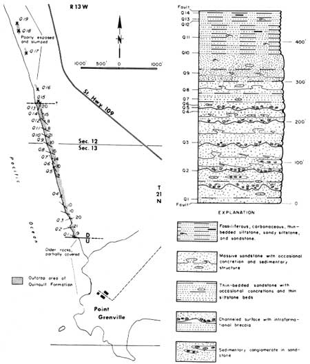
| FIGURE 2.—Section north of Point Grenville; columnar section and traverse. (click on image for an enlargement in a new window) |
SECTION NORTH OF POINT GRENVILLE
Beds of the section north of Point Grenville dip generally north-northeast between 10° and 25° (Fig. 2). This section is bounded on the south (base) almost certainly by an eastward-trending fault where it is in contact with badly distorted older rocks, which are nearly covered by deposits of slumped Pleistocene(?) sand and gravel. The north end (top) of the Point Grenville section also appears to be bounded by an eastward-trending fault. Thin-bedded strata exposed immediately south of this point swing from a northeast dip to an east dip, and at the contact the beds on the south side of the fault dip southeast, suggesting a downward drag on the south side of the fault. Although immediately north of this point the rocks are also part of the Quinault Formation, they are distinct from those of the Point Grenville section, in that they are largely a massive sandy siltstone and some fine grained sandstone. Some of the change in the attitude of the beds south of the fault may be due in part to slumping, but because of the major lithologic change at this point, it appears to be a fault contact that has been modified by slumping. Farther north from this contact, rocks are generally more massive and finer grained than those of the Point Grenville section and are more nearly like the beds of the Taholah section to the north.
Lithologically, the beds of the section north of Point Grenville are basically sandstone, as shown in the columnar section of Figure 2. They are characterized by numerous and large sedimentary structures, particularly in the lower part of the section. At least five irregularly channeled surfaces are present at various levels in the section. Immediately above each surface, large angular clasts, mostly of siltstone and other sedimentary rocks, usually fill these channels, together with numerous broken fossils. Thick-bedded to massive sandstone is common above and below these channels, and in places thin-bedded sandstone is also present. Excellent and large sedimentary structures are common. Some of these are: flame structures; scour-and-fill; and broken or "pulled apart" beds of thin, as well as thick, bedded sandstone. Horn (1969) discusses these features in detail. Approximately the lower 250 feet of section displays pronounced channeling and disruption of beds. The next 100 feet of section is rather massive sandstone, having only vague bedding and a few sedimentary structures. The uppermost 100 feet is very well bedded carbonaceous, fossiliferous sandstone and siltstone. These uppermost beds show only minor slump features.
Between the north end (top) of the Point Grenville section and the south end (base) of the section south of Taholah an interval of about three-quarters of a mile, the Quinault Formation is poorly exposed, slumped, and in one area is completely covered by Pleistocene(?) deposits.
SECTION SOUTH OF TAHOLAH
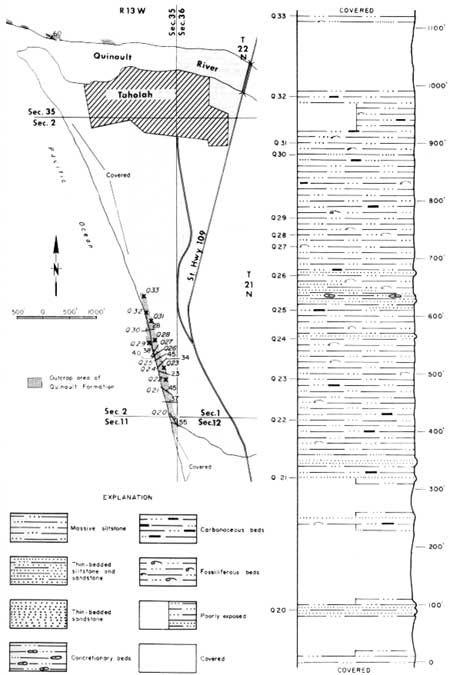
Immediately south of the mouth of the first major stream south of Taholah the Quinault Formation reappears and represents the base of the Taholah section (Fig. 3). Here the beds dip northeast, and northward from this point they gradually swing to a northwest dip at the north end of the section. Lithologically, this section is composed of uniformly massive siltstone, as shown in the columnar section of Figure 3. Bedding can usually be determined, but it is seldom obvious. A few thin beds of fine-grained sandstone are present; some of these are calcareous and therefore more resistant than the siltstone. Fossils and macerated carbonaceous material are common throughout the section. Concretions are rare, but a few do occur near the middle of the section. The Quinault Formation is concealed from the north end of the Taholah section to the Quinault River, a distance of about 1 mile.

|
| FIGURE 3.—Section south of Taholah; columnar section and traverse. (click on image for an enlargement in a new window) |
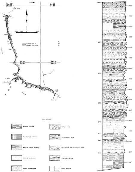
Immediately north of the mouth of the Quinault River, massive siltstone similar to that of the Taholah section reappears. It is poorly exposed at the base of landslides from this point westward for about a quarter of a mile, to a point where it appears to rest unconformably on badly disturbed and contorted older rocks (Fig. 4). This outcrop of slumped older rocks extends westward a few hundred feet, where it ends sharply against gently southeast-dipping conglomerate beds of the Cape Elizabeth section of the Quinault Formation. This sharp contact almost certainly represents a fault, which probably trends in a north-northeast direction and has the east side up. It appears that a major displacement has taken place at this point, as an upper part of the Cape Elizabeth section is in juxtaposition with the older rocks. Within this small distance of a few hundred feet it is possible, therefore, to see an upper and a lower part of the Quinault Formation separated by a small outcrop of older rocks.
CAPE ELIZABETH SECTION
From the fault contact described above, the Cape Elizabeth section is exposed westward and northward up the coast to a point about 1-1/4 miles north of Cape Elizabeth, where the Quinault Formation is in fault contact with the older, highly disturbed rocks. In this interval the Quinault Formation is almost continuously exposed in high cliffs and, at low tide, on the beach. As shown in the columnar section of Figure 4, the rocks consist largely of conglomerate, sandstone, and some sandy siltstone. The lower 300 feet of section is largely bedded fine-grained sandstone and sandy siltstone; also a considerable amount of carbonaceous material, some fossils, and a few concretions. Thin conglomerate beds first appear about 300 feet above the base of the section. They are overlain by about 150 feet of fine-grained sandstone and carbonaceous, fossiliferous siltstone. Some 500 feet above the base of the section, thick conglomerate beds occur as the dominant lithology and continue from this horizon to the top of the section. These conglomerate beds are interbedded with carbonaceous siltstone and sandstone beds, some of which are concretionary. Many of the surfaces between the conglomerates and other sedimentary beds are channeled. Much carbonaceous material is present throughout the section, some in the form of carbonized logs and branches. Marine invertebrate megafossils occur at several horizons in the lower part of the section, but none were found in the upper, conglomerate, part of the section. Foraminifera are extremely rare, and none were found in the upper 400 feet of the section. The beds dip variously from 10° to 20° consistently to the southeast and east, with the exception of the northernmost few hundred feet of exposure. There, a reversal can be seen, the dip being to the northeast, thus the beds dip in a direction opposite to the plane of the contact with the older rocks. This contact strikes northwest and dips moderately to the southwest. Within some 10 feet of the contact the beds are sharply dragged upward and actually dip steeply southward, thus indicating a downward drag on the south side of the fault contact. This contact has been variously interpreted as either a fault or a depositional contact. Weaver (1916a), among others, considered it to be a fault contact, whereas Glover (1945) believed it to be depositional. Winter storms of the 1968-69 season exposed much of the bedrock in the contact area; it could then be seen that the regional bedding in the Quinault Formation is at a distinct angle to the plane of the contact, thus indicating a fault that cuts across the bedding of the Quinault Formation.

|
| Figure 4.—Cape Elizabeth section; columnar section and traverse. (click on image for an enlargement in a new window) |
Older, badly disturbed rocks are exposed along the beach northward from this fault for some 1,400 feet. At the northern end of this outcrop the Quinault Formation is once again in fault contact with these older rocks. The plane of this fault strikes to the northeast and appears to dip moderately to the southeast (Fig. 5, on p. 9). The Quinault Formation is almost continuously exposed from this point northward nearly to the mouth of Duck Creek. However, in much of this area the strike of the beds is nearly parallel to the coast and the dips are to the east and southeast; therefore, very little section is exposed. Toward the northern part of this series of outcrops, the dip of the beds is reversed to a northerly direction, thus repeating the small section to the south. This series of outcrops is not described as a measured section of the Quinault Formation in this report, but they are regarded as isolated beds of the formation. These rocks are very fossiliferous, and therefore several localities in this area of outcrop are referred to in the present report. The beds are mostly siltstone with vague bedding, and they display much evidence of having been penecontemporaneously disturbed, perhaps by animal boring and also by bedding plane slump. They are similar to those beds exposed immediately north of Duck Creek that are in the upper part of the measured Duck Creek-Pratt Cliff section.
DUCK CREEK-PRATT CLIFF SECTION
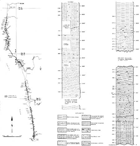
In the northernmost part of the outcrop area of the Quinault Formation, the Duck Creek-Pratt Cliff section extends continuously along the coast from the north side of Duck Creek to a point about 1,800 feet south of Camp Creek (Fig. 5). An estimated 700 feet of section is concealed north of this point, but the section appears again on the north side of Camp Creek and is continuously exposed north to Pratt Cliff, where, although also continuously exposed, it is not accessible. However, from offshore the beds appear to dip consistently southeast and to be uninterrupted throughout this area. On the basis of attitudes at the south and north ends of Pratt Cliff, it is estimated that some 1,400 feet of section is represented in this inaccessible area. The section is continuously exposed north of Pratt Cliff for a distance of about three-quarters of a mile. At this northernmost point the Quinault Formation rests unconformably on the badly disturbed older rocks. As shown on the columnar section of Figure 5, the basal 300 feet of this section is mostly bedded sandy siltstone showing frequent evidence of penecontemporaneously disturbed bedding, possibly the result of animal boring and bedding plane slump. Fossils are common, and small concretions are scattered throughout. The overlying 400 feet or so of section is mostly fine-grained thin-bedded sandstone. Some of these beds also show evidence of having been disturbed shortly after deposition, and some beds are carbonaceous. This interval of section is particularly characterized by numerous 4- to 8-inch-long concretion-like pear-shaped structures, the long axes of which are perpendicular to the bedding plane. They appear to have been cavities that were formed in the sediments, possibly by mollusks or some other boring type of animal, and were subsequently filled with additional sediments. No shell material was found in these structures. The uppermost 200 feet of section north of Pratt Cliff is a vaguely bedded silty sandstone containing scattered concretions. Some 500 feet of section exposed between the south end of Pratt Cliff and Camp Creek is largely a massive sandy siltstone. Penecontemporaneously disturbed beds and a few concretions are present in the lower 300 feet of this part of the section. Some 200 feet of section exposed immediately south of the mouth of Camp Creek is mostly silty fine sandstone and contains a few fossils and scattered concretions. The remaining nearly 1,000 feet of section exposed immediately north of the mouth of Duck Creek is largely sandy siltstone containing scattered fossils and concretions. Many of the individual beds in this interval show slump and churned-appearing sedimentary structures. The upper 300 feet or so is rather well bedded.

|
| Figure 5.—Duck Creek-Pratt Cliff section; columnar section and traverse. (click on image for an enlargement in a new window) |
Attitudes throughout this section, as shown in the traverse in Figure 5, indicate a rather gently undulating structure that dips mostly southeast, generally between 20° and 40°. At and near the basal contact to the north they dip to the southeast, then swing to a south dip a few hundred yards south of the contact, where the beds may be interrupted by possible faulting. South of this possible faulting the beds dip nearly due east, then a few hundred yards farther south they swing to a southeast dip once again and continue to dip southeast to the north end of Pratt Cliff. From offshore it appears as though rather steep southeast dips continue throughout Pratt Cliff. Fairly steep (30° to 40°) dips in a southeast direction continue to the top of the section at the mouth of Duck Creek.
| <<< Previous | <<< Contents >>> | Next >>> |
state/wa/1970-62/sec1b.htm
Last Updated: 01-Jun-2006