
|
Washington Department of Natural Resources Geology and Earth Resources Division Bulletin No. 66 Geology of the Washington Coast between Point Grenville and the Hoh River Weldon W. Rau |
PART II
Geologic Observations and Interpretations Along Segments of the Coast
BEACH TRAILS 5 TO 7
SAND AND GRAVEL CLIFFS
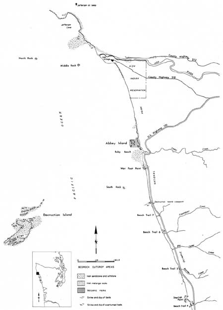
Sand and gravel deposits are very well exposed for a distance of nearly 2 miles from Beach Trail 5 to a short distance beyond Beach Trail 7 (fig. 62). With the exception of a few poorly exposed outcrops of jumbled deposits of Hoh rocks, all of the cliffs of this area are composed of clay, silt, sand, and gravel, most of which are believed to have been deposited during the Pleistocene Epoch.
|
| BEACH TRAIL 4 TO THE HOH RIVER—Coast Map. (Fig. 62) (click on image for an enlargement in a new window) |
Two major divisions of Pleistocene deposits can be easily recognized in this area. The younger of the two is a continuation of those sand and gravel deposits exposed above bedrock immediately to the south. The older unit, first appearing here at the base of the cliffs a short distance north of Beach Trail 5, is comparable to deposits at the base of the cliffs in the Whale Creek area some 12 miles to the south (see Part II, Raft River to Whale Creek, Older deposits of sand and gravel). However, between the Whale Creek area and Beach Trail 5 only the younger of the two units is exposed.
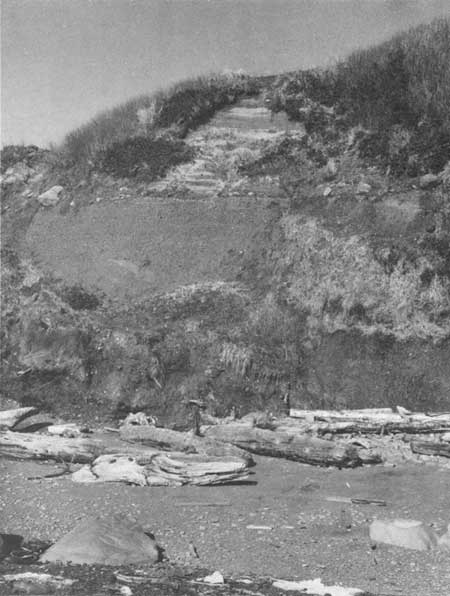
From Beach Trail 5 northward, the contact between the two units is sharply marked by a layer of large boulders and cobbles (fig. 63). Furthermore, the lower unit usually ls darker colored and in places parallel bedding is tilted, whereas parallel bedding appears nearly horizontal in the upper unit.
|
| TWO MAJOR UNITS OF SAND AND GRAVEL exposed in the cliffs immediately north of Beach Trail 6. The cobble and boulder studded, nearly horizontal contact between the two deposits represents the trace of a now elevated wave-cut surface that was developed on the lower unit prior to the deposition of the younger or upper deposits, some 70 thousand or more years ago. (Fig. 63) |
|
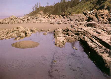
| STEEPLY DIPPING SAND STONE STRATA of the Hoh rock assemblage at Browns Point. These beds have been tilted beyond vertical to a slightly overturned position so that the original top of each bed now faces west (left). (Fig. 64) |
Both deposits are composed largely of sand and gravel. Clay is common in places in the lower unit. Some silt beds occur in the upper unit and they contain much plant material, including large pieces of wood. Some of this wood has been found to be older than 48,000 years. A similar conclusion was reached on wood from the upper unit in the Whale Creek area to the south.
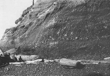
Gravels of both units are very largely graywacke sandstones with minor amounts of red chert, argillite, and volcanic rock. All were derived from rock formations of the Olympic Mountains and were carried by alpine glaciers to the foothills, then farther transported to the coastal area by numerous streams and rivers during the Pleistocene Epoch. In places some of the materials of the lower unit may have been deposited directly from glaciers with very little, if any, transport by streams. These deposits display no sorting or stratification, with materials varying in size from clay particles to large boulders. Such materials occur, in places, at the base of the cliffs northward to the Hoh River, and thus suggest that at one time ice extended down the Hoh valley at least as far west as the present-day coastline. Particularly good examples of these deposits are exposed at the foot of Beach Trail 7 and in places northward for about one-third of a mile (fig. 66).
|
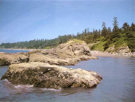
| STARFISH POINT, just north of Beach Trail 4, is relatively resistant sandstone and conglomerate of the Hoh rock assemblage. (Fig. 65) |
|
| UNSTRATIFIED DEPOSITS of clay, silt, sand, gravel, and boulders exposed in the base of the cliff at Beach Trail 7. The completely unsorted condition of such materials suggests little if any stratification by water, and therefore they were very likely deposited directly by glaciers. (Fig. 66) |
Similar to geologic relations in the Whale Creek area, the contact between the two units is the trace of an old wave-cut surface that was carved by the sea during the Pleistocene Epoch, and prior to the deposition of the upper unit. The large cobbles and boulders so common along the contact north of Beach Trail 5 are residual materials left behind when the surface was a tidal bench essentially at sea level. The large size of some of these boulders further suggests that they, as well as some of the materials removed, were most likely transported directly by ice rather than streams. Boulders that have been removed from the old wave-cut surface and redeposited at a lower level of the present-day wave-cut surface can be seen during low tide a short distance north of Trail 5 and on the beach at Trail 6 (fig. 67). Particularly large boulders are also present in the streambed adjacent to Beach Trail 7.

|
| A BOULDER-STREWN BEACH NEAR BEACH TRAIL 6. As the sea erodes the coastline eastward, boulders were redeposited here from an ancient, now elevated beach level. The boulder-studded trace of this old elevated beach surface is visible in the adjacent cliffs of this area. (Fig. 67) |
Northward from the first appearance of the lower sand and gravel unit, a short distance north of Beach Trail 5, the boulder contact is seen progressively higher in the cliff. At Beach Trail 7 about 1-1/2 miles northward, it is over 35 feet above the high-tide level. Therefore, this surface dips gently southward, whereas in the Whale Creek area it dips gently northward. Thus, between these two areas, some 12 miles apart, it appears the earth's surface has been broadly downwarped some time after the wave-cut surface was formed.
SANDSTONE BLOCKS OF HOH MELANGE
In an area north of Beach Trail 6 and immediately south of Trail 7, a number of sandstone blocks are scattered on the beach and others are protruding from the basal part of the vegetated cliffs. These blocks are most likely residual materials that were left behind as the sea eroded structurally complex and chaotically mixed deposits of Hoh rocks (see Part I, Tectonic melange of the Hoh rock assemblage). Such materials are well exposed to the south in the Hogsbacks area and also between Cape Elizabeth and Duck Creek. In these latter areas the relatively soft, finer grained matrix materials in which sandstone blocks occur are well exposed. However, between Beach Trails 6 and 7 vegetation masks much of the low-lying outcrop area, and only in small isolated places can the soft matrix materials be seen at the base of the cliffs.
Note the distinct green color of many of the sandstone blocks. This is due to an abundance of glauconite, a green colored mineral that is known to form on the bottom of the sea, thus indicating that these sandstones are indeed marine in origin.
BEACH TRAIL 7 TO RUBY BEACH
Both the younger and the older deposits of sand and gravel are well exposed in the high cliffs that extend northward for about one-third of a mile from Beach Trail 7. In the vicinity of the highway sign for Destruction Island, the straight coastline is broken by a small sandstone point that protrudes from beneath the sand and gravel. This massive sandstone is another small outcrop of Hoh rocks. These strata are dipping steeply to the southeast and are several hundred feet thick. Intensely sheared Hoh siltstone is sometimes exposed for a short distance both to the north and south at the base of the cliffs. Similar materials are present but very poorly exposed at the base of much of the heavily vegetated sloping bluffs that extend northward from the sandstone point for about one mile to Wet Foot Point (fig. 62). Because badly broken and unctuous Hoh siltstone beds are relatively incompetent or weak, they are particularly vulnerable to erosion and furthermore serve as a poor foundation for the overlying sand and gravel deposits. Therefore, for nearly a mile much slumping has occurred, modifying the cliffs to sloping surfaces where vegetation can grow more easily than on the nearly vertical cliffs to the south.
Foraminifera from siltstone beds exposed at the base of the cliff immediately below the Destruction Island viewpoint sign are similar to those known from the Beach Trail 5 area (see Part II, Starfish Point to Beach Trail 5). They, too, indicate that the strata in which they occur were originally deposited in the sea during early Miocene time some 15 to 22 million years ago.
South Rock (fig. 68), the prominent offshore stack about three-quarters of a mile to the west of this area, is a resistant Hoh sandstone remnant. It is similar to the sandstone that forms the point immediately north of the Destruction Island viewpoint sign.

|
| SOUTH ROCK, a erosional remnant from Hoh rocks about three-quarters of a mile offshore between Beach Trail 7 and Ruby Beach. (Fig. 68) |
| <<< Previous | <<< Contents >>> | Next >>> |
state/wa/1973-66/sec2-13.htm
Last Updated: 28-Mar-2006