
|
Washington Department of Natural Resources Geology and Earth Resources Division Bulletin No. 66 Geology of the Washington Coast between Point Grenville and the Hoh River Weldon W. Rau |
PART II
Geologic Observations and Interpretations Along Segments of the Coast
BETWEEN POINT GRENVILLE AND TAHOLAH
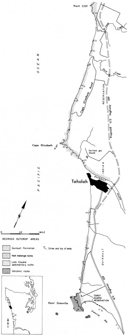
Northward from Point Grenville for at least a quarter of a mile (fig. 29) the cliffs are extensively slumped. In the first cove, immediately north of the main body of the Point Grenville volcanics, broken, well-bedded sandstones and siltstones of late Eocene age, similar to those exposed to the east in Grenville Bay, are exposed at the base of the slumped cliff.
|
| POINT GRENVILLE TO PRATT CLIFF—Coastal Map. (Fig. 29) (click on image for an enlargement in a new window) |
JUMBLED ROCKS
The large volcanic boulders at the base of the small headland between the first and second coves are most likely resistant blocks from jumbled Hoh rocks. These and other similar deposits are sometimes referred to as a "tectonic melange" (see Part I, Tectonic melange of Hoh rock assemblage). They are comprised of broken and sheared claystone and siltstone in which resistant blocks, mostly of sandstone and volcanic rocks, are incorporated.
Apparently in recent years erosion by wave action has caused the boulders that form the base of this headland to move seaward, thus a landslide has formed in the overlying material. Note that the overlying sand and gravel deposits are dipping significantly to the east (fig. 35).
Northward from these boulders the cliffs of the second cove are also extensively slumped because they too are underlain by jumbled Hoh rocks. In places, where these deposits have been exposed to moisture, they have moved outward essentially as mudflows. Blocks of sandstone from the jumbled deposits can be seen in places at the base of the cliffs under the overlying slumped sand and gravel debris.
SANDSTONE STRATA OF THE QUINAULT FORMATION
An abrupt, nearly vertical cliff of sandstone forms the north edge of the second major cove some quarter of a mile north of the volcanics of Point Grenville (fig. 29). Here Hoh rocks are in fault contact with the gently dipping sandstone beds of the Quinault Formation. These sandstone beds were deposited in the sea during the Pliocene Epoch, about 7 to 1.5 million years ago (fig. 2). Because the Quinault Formation is much younger than the underlying rocks, its strata have undergone only moderate tilting compared to the highly folded and contorted older rocks. Sandstone and siltstone beds of the Quinault Formation are exposed in several major and continuous outcrops from this point northward to Taholah beneath a 50- to 100-foot thickness of the same relatively young sand and gravel deposit that caps Point Grenville.
The southernmost of these sections of continuous outcrops begins at this contact with Hoh rocks and extends northward for nearly 1 mile. The strata are mostly sandstones and are gently dipping in a northeastwardly direction. This sequence of beds is at least 500 feet thick.
Fossils and Sedimentary Features
A marine origin for these beds is indicated by the presence of fossil remains of marine organisms such as clams and snails, together with microscopic fossils of Foraminifera (fig. 13). Paleontologists have further determined from these fossils that the sandstone beds were deposited in relatively cool water. The geologic age (Pliocene) of these strata has also been determined by fossils.
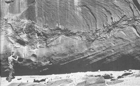
Particularly well-developed features of ancient sedimentation are excellently preserved in these strata. Evidence of alternating conditions of deposition and erosion by local currents can be seen at several levels. Cross sections of channels that were scoured by local currents while the sediments were still semiconsolidated are now seen filled with broken parts (sand, pebbles, and some shell fragments) of the Quinault Formation (fig. 30). Such conditions suggest an environment on or near a delta or similar setting where shifting deposits and channel scouring takes place. Many other sedimentary structures that were formed during or shortly after deposition also can be seen in these cliffs (fig. 15).
|
| CROSS SECTION OF SCOUR AND FILL STRUCTURES exposed in the sea cliffs of the Quinault Formation north of Point Grenville. The erosion of these and other channels represent a short break in the depositional record. They were subsequently filled rapidly with coarse rock debris from the formation. This was followed by the deposition of the overlying massive sand above. (Fig. 30) |
Landslide Area
Northward along this outcrop area the Quinault Formation becomes fine grained and thin bedded. At its northern end, a mile or so north of Point Grenville, the rocks are largely thin-bedded siltstone with only minor amounts of very thin beds of sandstone.
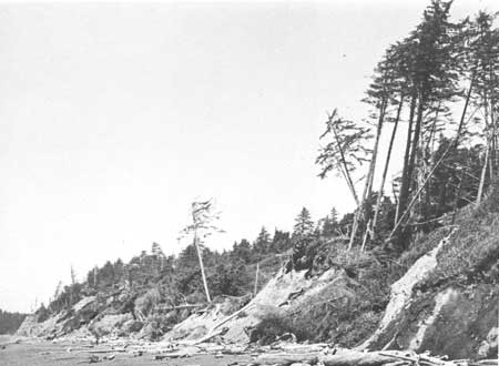
From this area northward for over a quarter of a mile, landslides are prevalent in both the Quinault Formation and overlying younger deposits of sand and gravel (fig. 33). Large rotated blocks of sand and gravel have moved out and downward from their original position. Trees and other vegetation on these blocks are now tilted, creating a "drunken forest." In places, siltstone of the Quinault Formation also can be seen in discontinuous outcrops at the base of the cliffs and on the beach at low tide. Slumping in this area is most likely due to the structural weakness of siltstone of the Quinault Formation that crops out in this particular area. Unstable conditions created along a continually eroding coastline make these relatively soft rocks somewhat susceptible to landsliding.

|
| SILTSTONE INTERBEDDED WITH VOLCANIC ROCKS at Point Grenville. The contorted light-colored layers are calcareous. Because they are generally harder than the surrounding materials, they weather out as irregular nodules. (Fig. 31) |
SAND AND GRAVEL OF THE ICE AGE
Along the next quarter of a mile or so northward to the mouth of a major stream (fig. 29), only deposits of sand and gravel are exposed in the sea cliffs. They are the same Pleistocene glaciofluvial materials that overlie the older bedrock along the coast from Point Grenville to this area.
SILTSTONE OF THE QUINAULT FORMATION
Continuing northward and ending abruptly about three-fourths of a mile south of Taholah, the Quinault Formation is again exposed almost continuously for nearly an additional one-half mile in the basal 50 feet of the cliffs (fig. 29). Here, the formation is largely massive to vaguely bedded siltstone and is gently tilted to the north (fig. 32). Occasionally beds of sandstone are present and fossil remains of clams and snails, together with tiny Foraminifera, are common. A total thickness of nearly 1,000 feet of continuous deposition is represented in this tilted sequence of sedimentary rocks. The fossils suggest to paleontologists that these strata were deposited in cold, fairly deep water (see Part I, The Quinault Formation, south of Taholah).

|
| MASSIVE SILTSTONE OF THE QUINAULT FORMATION (the darker colored basal part of the cliff) beneath a thickness of nearly 100 feet of late Pleistocene outwash sand and gravel, exposed in the cliffs about 1 mile south of Taholah. The contact between the two formations is an elevated wave-cut surface that was carved by the sea during the Pleistocene Epoch prior to the deposition of the overlying deposits over 70,000 years ago. (Fig. 32) |
|
| A MAJOR LANDSLIDE AREA about 1 mile north of Point Grenville. For nearly a quarter of a mile, large blocks of sand and gravel have moved seaward and rotated the land surface so that trees are variously tilted to form a "drunken forest." Structural weakness of underlying massive siltstone of the Quinault Formation is probably the cause of the landsliding in this area. (Fig. 33) |
|
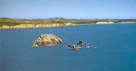
| WILLOUGHBY ROCK, a resistant remnant of the Hoh rock assemblage, as it appears from the air. The Quinault Formation forms the high cliffs along the coastline. Pratt Cliff extends from the left to center; Camp Creek is in the wide low area; and the Duck Creek valley is the small low area on the right. (Fig. 34) |
Sand and gravel deposits overlying the bedrock in places reach a thickness of nearly 100 feet. Locally, some 30 feet from the top of the cliff, a zone of silt can be seen that contains large amounts of plant material including remains of logs and stumps. These materials represent an intermittent period of lake or swamp (lacustrine) deposition. Wood samples from this bed were radiocarbon dated and found to be over 30,000 years old.
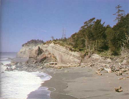
|
| A LANDSLIDE immediately north of Point Grenville in Pleistocene deposits of sand and gravel underlain by large volcanic boulders of Hoh rocks. Note that the normally horizontal Pleistocene strata are now dipping significantly to the east. The underlying boulders most likely moved seaward when they were undercut by erosion, enough to cause the overlying materials to be tilted eastward. (Fig. 35) |
TAHOLAH SANDSPIT
From the north end of the Quinault Formation outcrop area to the Quinault River, a distance of nearly a mile, only Recent deposits of beach sand are exposed. The retention and further accumulation of these sediments has been aided by an artificial levee built some years ago.

|
| PRATT CLIFF, where gently southward-dipping strata of the Quinault Formation are well exposed but inaccessible from the beach. The nearly flat land surface on bedrock of the Quinault Formation represents an old uplifted wave-cut surface that was formed at sea level sometime during the Pleistocene Epoch. (Fig. 36) |
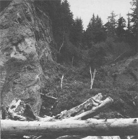
|
| JUMBLED HOH ROCKS in the low-lying area on the right in contact with a fault scarp formed on the more resistant, gently dipping sandstone and conglomerate beds of the Quinault Formation on the left. This outcrop is exposed along the coast about one-quarter of a mile north of the mouth of the Quinault River. (Fig. 37) |
| <<< Previous | <<< Contents >>> | Next >>> |
state/wa/1973-66/sec2-2.htm
Last Updated: 28-Mar-2006