|
Washington Department of Natural Resources Geology and Earth Resources Division Bulletin No. 66 Geology of the Washington Coast between Point Grenville and the Hoh River Weldon W. Rau |
PART II
Geologic Observations and Interpretations Along Segments of the Coast
WHALE CREEK TO THE QUEETS RIVER
For about 3 miles northward from Whale Creek to nearly the mouth of the Queets River, iron-stained sand and gravel deposits are rather uniformly exposed in the some 80-foot-high cliffs (fig. 55). With the exception of the older beds at the base of the cliffs near Whale Creek, all of these materials were deposited during a late part of the Pleistocene Epoch, between 17,000 and possibly 70,000 or more years ago. They were originally removed by a late period of alpine glaciation from bedrock outcrops, mostly of sandstone (graywacke), exposed somewhere in the Olympic Mountains. These stones and sand and silt grains were farther transported by streams and rivers from the glacial fronts and deposited in the coastal area, forming a broad piedmont surface that extended westward from the foothills of the Olympics. At one time this piedmont surface (the present surface at the top of the cliffs) probably extended much farther westward. However, over the past thousands of years, the continual erosion by ocean waves has caused the coastline to recede eastward in places at the rate of as much as 375 feet every 100 years (see Part II, The Hogsbacks area, Coastal erosion). As a result, today's wave-cut surface, or beach level, is some 80 feet below the old piedmont whose very gently sloping surface, at one time, extended westward to sea level (see Part I, Cenozoic deposits).

|
| LOOKING NORTHWARD FROM WHALE CREEK at the nearly straight coastline to the Queets River. The cliffs are semiconsolidated silts, sands, and gravels deposited by streams from melting valley glaciers that extended westward from the Olympic Mountains during the Pleistocene Epoch. Most of these deposits probably were laid down between 17 and 70 thousand years ago. (Fig. 55) |
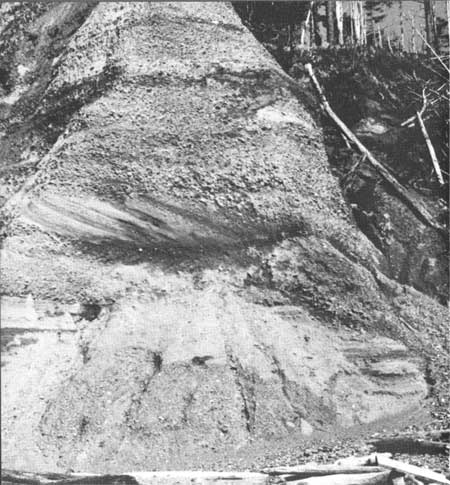
Many features of sedimentation can be seen in these cliffs. For the most part, the various beds of sand and gravel appear nearly horizontal. However, locally, others display cross bedding, a pattern indicating rapid deposition at different slopes and directions, as would be expected at the edge of a delta or along the edge of a steeply sloping river bank (fig. 56). Evidence of much channeling by streams, or the local eroding instead of depositing of materials, can be seen in places. These features all indicate that during the melting of the glaciers numerous streams and rivers flowed over much of the area continually changing channels, depositing in places for a time, and then shifting and perhaps eroding for a time in another place.

|
| CROSS STRATIFICATION in beds of sand and fine gravel exposed about one-fourth of a mile north of Whale Creek. This pattern indicates rapid deposition at the edge of a delta or along the edge of a steeply sloping river bar. (Fig. 56) |
Although these deposits appear to be nearly horizontal, they dip slightly northward. This gentle tilt is perhaps best observed by following the dark-colored carbonaceous clay and wood layer seen only a few feet below the top of the cliff near Whale Creek. It gradually appears lower and lower in the cliffs northward from Whale Creek until finally the layer extends beneath the level of the base of the cliff. This carbonaceous bed represents a local impounding of water, such as a shallow lake or a swamp in which only fine-grained sediments were deposited together with the vegetation that grew in and around the impoundment. The bed, therefore, was formed originally in a horizontal plane.
Erosion by springs and surface streams has serrated the high, nearly vertical cliffs that form the otherwise straight coastline for nearly 3 miles between Whale Creek and the Queets River valley.
| <<< Previous | <<< Contents >>> | Next >>> |
state/wa/1973-66/sec2-9.htm
Last Updated: 28-Mar-2006