
|
Washington Department of Natural Resources Geology and Earth Resources Division Bulletin No. 72 Washington Coastal Geology between the Hoh and Quillayute Rivers Weldon W. Rau |
PART II
GEOLOGIC OBSERVATIONS AND INTERPRETATIONS ALONG THE COAST
(continued)
FIRST BEACH, JAMES ISLAND, AND VICINITY
The bedrock of First Beach is largely concealed with unconsolidated deposits brought to the area during Pleistocene and Recent times by the Quillayute River and its tributaries. Hoh bedrock is exposed only at the headland of Quateata to the south (fig. 70), and James Island and nearby islands to the north (fig. 73). The bedrock of Quateata, as discussed under the section on Second Beach, is believed to be a part of a sedimentary rock sequence that includes the rocks exposed both at the "Quillayute Needles" and Teahwhit Head to the south (fig. 25). Hoh strata of the James Island area trend northward beneath the concealed area of the river and breakwater to the Rialto Beach area. There, these strata underlie a north-trending ridge where they are exposed in places along the road to Rialto Beach and in ravines of that area. Because a major fault is thought to extend northeastward somewhere through the First Beach area, the James Island-Rialto Beach sequence of sedimentary rocks are believed to be structurally distinct from those of Quateata and other areas to the south.
HISTORICAL NOTES
JAMES ISLAND
Traditions, legends, and recorded history relate many fascinating early events in the lives of the Quileute people, some of which directly or indirectly are related to geology. Outstanding among the stories about their way of life is their use of James Island as a very efficient fort against their enemies. James Island, said to have been named after a tribesman, James Howe, originally was called Ah-kah-lahkt (meaning way up there or on top of the hill; Alcorn and Alcorn, 1976). Conflict between the Quileutes and the Makahs to the north apparently began several hundred years ago and lasted for at least 100 years. With only one precarious route to the nearly 5-acre flat surface, James Island served as a natural fort for the Quileutes (fig. 68). Food grown on the island and water from springs served much of their needs. Hot water and large boulders thrown over the side were important weapons used by the Quileute and the sheer walls, 180 feet high, mostly of Hoh sandstone, afforded excellent protection. Geology and rock formations, therefore played an important role in the well being of the Quileute people.
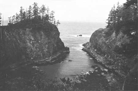
The headland of Quateata is largely massive sandstone; but stratification is apparent in places where it clearly indicates that the beds are dipping steeply to the northwest and strike to the northeast. This structural trend is reflected well on the headland surface to the west of the quarried area where the natural surface is essentially a DIP SLOPE surface (fig. 70). Furthermore, the several northeast-trending fingerlike bays and projections that form Quateata distinctly reflect structural lineation manifested by differential erosion of the sedimentary rocks of this headland. The northeast structural trend at Quateata, as well as the east trend on James Island, is most likely the result of drag caused by STRIKE SLIP movement on the fault extending through the First Beach area (fig. 25).

|
| THE HEADLAND OF QUATEATA as viewed from First Beach. The steeply sloping surface developed on the undisturbed western portion of this headland is an expression of the structural trend of the sandstone and conglomerate strata that form this headland. Pleistocene deposits capping bedrock are well exposed in the quarried area to the left. (fig. 70). |
Pleistocene deposits are also well displayed in the quarried area (fig. 70). Orange-colored outwash sand and gravel that was deposited by streams from glaciers during the Pleistocene Epoch rests on the now-elevated Pleistocene sea-level surface. Wind-blown, buff-colored silt and sand that blankets much of the coastal area is well-displayed in the uppermost part of this outcrop (fig. 12). These materials are estimated to have been deposited some 8,000 years ago (see Deposits of the Ice Age, Part I).
HISTORICAL NOTES
EARLY CONTACTS WITH WHITE MEN
Although no date has been established, the first white men to have made contact with the Quileutes were survivors with Spanish-sounding names from a ship wrecked on nearby offshore rocks (Hobucket, 1934). The Quileutes are said to have referred to the shipwrecked people as the "drifting white race." Because they had never seen white people before and because the white men came from the ocean, the Quileutes thought the ocean was their only home. As the story goes, the shipwrecked crew stayed with the Quileutes for many years. Then finally, they left, headed south, never to be heard from again.
Another shipwreck is thought to have had a French-speaking crew. The event must have taken place during the early days of steamships as the ship was described as a "side-wheeler. The location of the wreck apparently was in the immediate area of La Push. It is said to have been loaded with merchandise, food, and several chests of gold coins. The value of the gold coins was not revealed to the Quileutes, so they simply allowed them to sink in the sand. Later these shipwrecked people left the area and headed south. They, too, were never heard from again (Hobucket, 1934). The French word "la bouche," meaning mouth, may be the origin of the name "La Push," perhaps as a descriptive reference by the French visitors to the mouth of the Quillayute River.
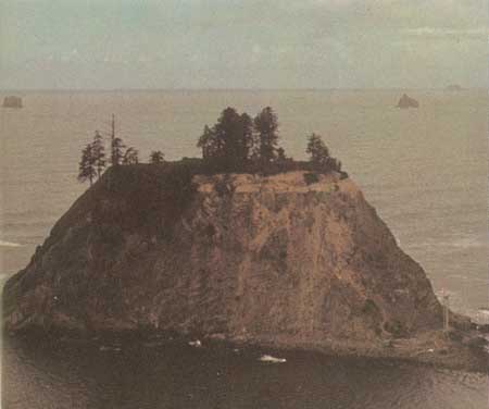
The bedrock of James Island and nearby islets is largely massive sandstone. Stratification is rare but may be observed in several places on the main island and also on the northernmost island of the group. The horseshoe shape of James Island (fig. 71) is a structurally controlled feature and is the result of differential erosion by wave action. A thin, relatively soft siltstone strata, dipping steeply northward and trending eastwardly through the central area of the island, has eroded more rapidly relative to the massive sandstone of the rest of the island. The result, over thousands of years, has been elongate reentrant or the inner bay of the island.
|
| THE INNER BAY OF JAMES ISLAND. The horseshoe-shape of the island has resulted from differential erosion by wave action. A thin, steeply dipping siltstone bed extending westward through the bay area has eroded more rapidly than the adjacent sandstone of the island (fig. 71). |
Like Quateata, James Island and some of the surrounding islets are also capped with Pleistocene deposits of sand, gravel, and wind-blown sediments. The trace of the Pleistocene elevated wave-cut terrace upon which the deposits rest is particularly well exposed on the northernmost island—"Little James Island" (fig. 72).
|
| "LITTLE JAMES ISLAND" is the northernmost islet of the James Island group. Its gravel-covered, flat-top surface exemplifies Pleistocene deposition on an ancient elevated wave-cut surface (fig. 72). |
HISTORICAL NOTES
LA PUSH HARBOR
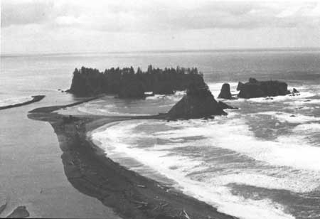
Records of more recent and geologically related events reveal how the Quillayute River has entered the sea at various locations through the years. Documents (U.S. Army Corps of Engineers, 1950) state that in 1876 the mouth of the river, approximately at its present location (fig. 73), was closed by a log jam, and the river broke through the sand spit at its upper end to form a new outlet (the area now occupied by the picnic area at Rialto Beach). By 1911, the mouth of the river had migrated southward on the spit and sometime later it moved to its present location. A sketch of the La Push area in a 1909 publication (Reagan, 1909) verifies that at the time only a lagoon existed where the La Push harbor is today, and that the river entered the sea in the Rialto Beach area (fig. 74). It was not until 1931 that the U.S. Army Corps of Engineers constructed a dependable harbor at La Push by completing a dike extending from the existing sand spit to James Island and a jetty on the opposite side of the river. Periodic repairs of the installations followed through the years with a major restoration in 1946. In the 1950's the channel and basin were deepened and the jetty on the east side of the river's mouth was raised to a height of 15 feet above low-tide level. Materials for the dike and jetty were quarried from the Hoh sandstone and conglomerate exposed on the north side of Quateata at the south end of First Beach. A quarry was also opened in Hoh sandstone on the east side of the northernmost islet of the James Island group, "Little James Island" (fig. 72).
|
| JAMES ISLAND and surrounding islets viewed from the north. Today the Quillayute River is guided by a dike and a jetty so that it enters the sea along the southeast side of James Island (fig. 73). |

|
| LA PUSH HARBOR AREA, 1909. The Quillayute River has entered the sea at various locations through the years. This 1909 sketch map shows that its mouth was then in the vicinity of the present-day picnic area at Rialto Beach (Reagan, 1909) (fig. 74). (click on image for an enlargement in a new window) |
| <<< Previous | <<< Contents >>> | Next >>> |
state/wa/1980-72/sec2-9.htm
Last Updated: 28-Mar-2006