
|
University of Washington Publications in Geology
The Geology of the San Juan Islands |
DESCRIPTIVE GEOLOGY
SEDIMENTARY ROCKS
GENERAL CHARACTER
The sedimentary rocks exposed on the San Juan Islands range front middle Paleozoic to Recent in age.
The Paleozoic rocks belong to one more or less conformable series, known as the San Juan series.1
1McLellan, R. D., The Devonian Orcas Groups of Washington: Amer. Jour. Sci., 5 Ser., vol. 8, p. 217, 1924.
The lower portions of the San Juan series are composed largely of cherty quartzite and argillite with scattered lens-shaped deposits of crystalline limestone. The upper portions of the series have a more varied lithology, but tuffaceous graywacke, argillite, schist, and conglomerate are the most abundant rock types. Almost all of the Paleozoic rocks are highly metamorphosed.
On Vancouver Island there is a series of rooks known as the Sicker series2 which is apparently unfossiliferous. It is suspected by the writer that the Sicker series and the San Juan series are identical, even though the former has been provisionally correlated with the Jurassic.
2Clapp, C. H., Southern Vancouver Island: Geol. Survey Canada, Summary Report, 1909. pp. 88-89, 1910.
The Mesozoic sedimentary rocks occurring on the San Juan Islands belong to the Triassic, lower Cretaceous, and upper Cretaceous systems. They are composed chiefly of conglomerate, arkosic sandstone, and shale. Mesozoic limestone beds are small and quite rare in this region. The Mesozoic rocks, particularly those belonging to the upper Cretaceous system, are only slightly metamorphosed. The Tertiary rocks are composed of unmetamorphosed arkosic sandstones and conglomerates of brackish or fresh water origin. The Tertiary and late Mesozoic rocks have apparently been subjected to the same period or periods of folding.
During the Pleistocene period the glaciers cut deeply into the older formations and, on retreating, left a thick mantle of glacial drift on many of the islands.
DEVONO-MISSISSIPPIAN SYSTEMS
ORCAS GROUP
Principal Features. The Orcas group3 is the oldest one exposed on the San Juan Islands, and the outcrops are all included within a belt 22 miles long and 10 miles wide. The underlying strata are covered by the waters of the sea. The Orcas group is overlain with approximate conformity by the tuffaceous graywackes of the Leech River group. The rooks of the Orcas group are complexly folded and contorted, while fracture zones and faults of un known magnitude further complicate the structure. Up to the present time it has not been possible to distinguish the Devonian formations from those belonging to the Mississippian.
3McLellan, R. D., The Devonian Orcas Group of Washington: Amer. Jour Sci., 5 Ser., vol. 8, pp. 217-222, 1924.
Lithology and Structure. The Orcas group was laid down by normal processes of marine sedimentation in fairly deep water and at a considerable distance from the shore. Periodic conditions produced thin strata of fine grained and perhaps semi-colloidal silica sands alternating with thin strata of mud. The sediments have been highly metamorphosed and contorted as a result of folding and igneous intrusions.
The outstanding lithological component of the Orcas group is a light bluish-gray chert. The chert is so badly fractured and the joint planes so intricately recemented by white quartz that it is impossible to obtain a thin section that will not show several quartz veinlets within its area. The veinlets are usually parallel for the bedding plane and in places they are so abundant that the rock passes into a cherty quartzite.
The chert strata range from half an inch to three inches in thickness with an average of slightly more than an inch. Each band of chert is separated from the next by layers of argillite. The thickness of the argillite bands is generally slightly less than that of the chert layers and they vary in color from light brownish-gray to dark brown. Near the uppermost part of the Orcas group the rhythmical alternation of thin strata of chert and argillite is somewhat broken. Occasional strata of argillite here reach a thickness of several feet, while above and below them the regular alternation of thin strata persists. By differential erosion, especially along the coast, the argillite layers have been largely removed, while the cherty layers stand out in relief and present a surface and structure resembling that of shredded wheat. The argillite has a tendency to pass into the chert, although in places it is highly schistose.
Thin sections of the chert show numerous small round "spots" filled with quartz, and these are occasionally present in the interbedded argillites. The size of the "spots" is approximately that of the radiolarians seen in the cherts of the Franciscan formation of California, and since radiolarian cherts have also been found in northern California4 in formations of similar age and lithology, it is assumed that the quartz-filled "spots" were originally radiolarian tests which have since recrystallized. A recent examination of selected samples of the chert has revealed the fact that the "spots" are due to microorganisms which were probably radiolarians. These microorganisms occur in such a poor state of preservation that little can be specifically learned concerning them.
4Diller, J. S., Mineral Resources of Southwestern Oregon: U. S. Geol. Survey, Bull. 546, pp. 15-16, 1914.
Numerous lens-shaped beds of limestone occur interbedded with the cherty quartzite. These are not confined to any one horizon, but occur scattered throughout the whole group. However a fairly persistent series of lenses occur at a horizon near the lowest part of the group exposed, and another one near the top of the group. The limestone is always recrystallized and recemented with calcite. In the vicinity of igneous dikes, the limestones are usually silicified and irregular masses of flint are found. Limestone beds occurring in the vicinity of aplite and pegmatite dikes are sometimes replaced by contact minerals such as tremolite and wollastonite. Still other limestones contain a considerable quantity of carbonaceous matter, and in such cases the limestone is black in color and the joint planes are often covered with glistening films of graphite. The limestones of the Orcas group contain remarkably low percentages of magnesium, and this fact is all the more remarkable when it is considered that they are frequently intruded by dikes of igneous materials containing high percentages of magnesium.
A series of cherty and tuffaceous graywackes having a thickness exceeding a hundred feet appear to occupy a definite horizon somewhat higher than the middle of the Orcas group. It is possible that this horizon marks the dividing-line between the Devonian and the Mississippian.
|
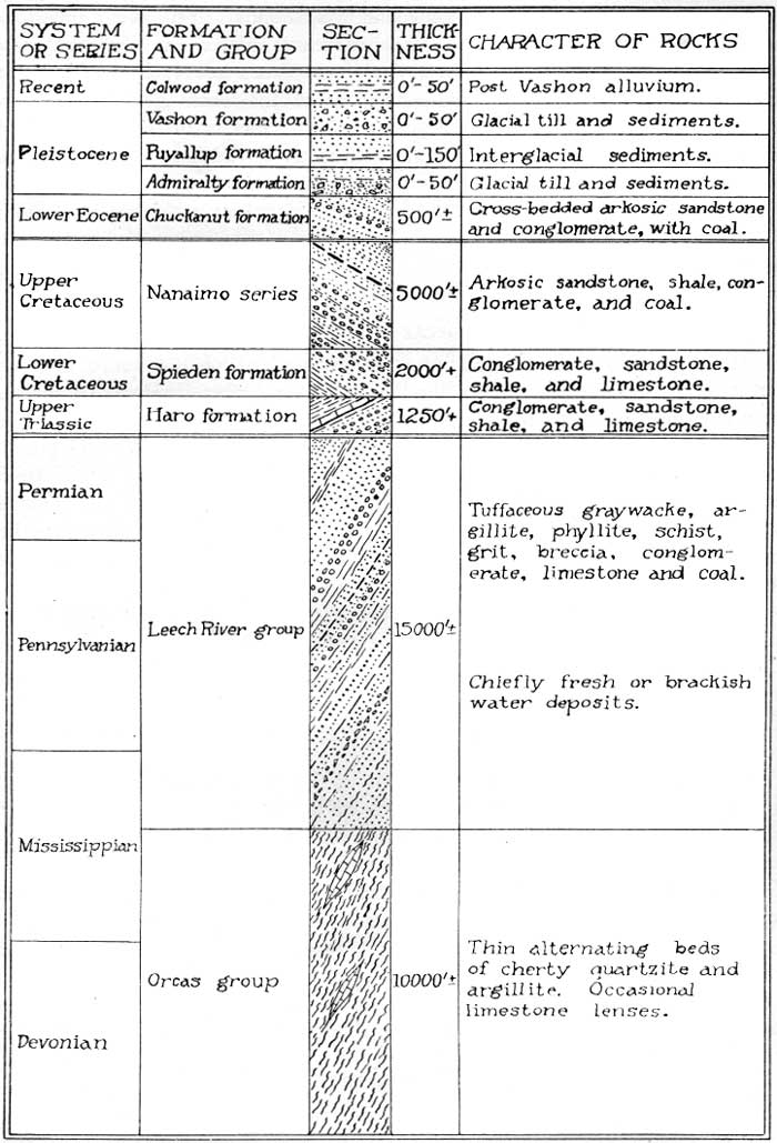
| Figure 1. Table of Formations. (click on image for an enlargement in a new window) |
ORCAS ISLAND
It is possible that the conglomerate exposed along the shore near the foot of Orcas Knob represents the base of the Orcas group. The coarse greenish sandstone that forms its matrix greatly predominates over the enclosed boulders which consist chiefly of altered andesite, quartzite, and granite. Its thickness is at least 35 feet. The conglomerate is overlain by 25 to 50 feet of thin alternating beds of quartzite and argillite and these are followed by a fairly persistent limestone bed about 30 feet thick. This limestone bed contains Devonian fossils and the surrounding rocks are somewhat less metomorphosed than those occurring in other parts of the region.
The limestone is overlain by thin-bedded quartzite and agillite, the former being cherty only at intervals. Like the true cherts which occur farther up in the group, this material contains the quartz-filled "spots." It is noticeable that some of the chert strata of the Orcas group contain a much larger number of the quartz-filled "spots" than others. Some of the cherts are, free or nearly free from the quartz-filled "spots."
The succeeding strata are so broken up by igneous intrusions of several ages, that scattered remnants of the chert are all that remain. These remnants usually retain the same general strike and dip as that of the unintruded portions, i. e., the strike is northeast and the dip southeast. On the western half of Orcas Island the igneous intrusions take the form of a wide belt or zone running parallel to the strike of the chert. To the southeast of this igneous belt, which is shown on the accompanying geological map as the Turtleback Complex, the cherts are again almost free from igneous intrusions. If a straight line be drawn northeastward from Reef Island to the village of West Sound and continued on towards East Sound, it would mark the southern or upper boundary of the igneous belt.
In the southern part of Orcas Island the major trend of the Orcas group is modified by the presence of several minor folds which trend north and south or slightly northwest and southeast. The southern part of East Sound follows a minor anticlinal fold, while the structure of the region to the south of Mount Woolard is complicated by faulting.
The cherty rocks of the Orcas group appear along the west and northwest sides of the Mount Constitution Range. Here they trend northeasterly and dip towards the southeast at a moderate angle. These rocks make up the upper part of the group on Orcas Island and they contain several large limestone lenses which appear to belong to the same horizon as those occurring to the north of Mount Woolard.
VICTIM ISLAND
The cherty rocks occurring on Victim Island trend about N 60° W and dip towards the southwest. The same attitude is assumed by the rocks along the shore of Orcas Island to the west of Victim Island. The cherts on this island are cut by several igneous dikes or sills which follow the general trend of the sedimentary rocks.
DOUBLE ISLAND
The Orcas cherts occurring on Double Island have the same general trend and dip as those on Victim Island. The peninsula between West Sound and Deer Harbor is located on the axis of a minor synclinal fold which plunges towards the southward. The cherty rocks occurring on Double Island and on Victim Island are a part of the eastern limb of this fold.
BELL ISLAND
Bell Island is located on the axis of the synclinal fold which embraces the peninsula to the northward. The cherty rocks are here so broken up that they are practically structureless.
CRANE ISLAND
The western limb of the synclinal fold mentioned above embraces the rocks of the Orcas group occurring on Crane Island. In general these rocks are badly broken and dislocated, but they commonly trend northeasterly and dip towards the southeast. Near the southwest corner of Crane Island there is a limestone lens which is apparently a continuation of the limestone ledges occurring on Cliff Island.
CLIFF ISLAND
The cherty rocks belonging to the Orcas group which occur on Cliff Island, trend northeasterly parallel to the long direction of the island. They dip steeply towards the southeast. A series of large limestone lenses occur along the northwest shore of the island. Intrusions of the Eagle Cliff porphyrite have destroyed a large part of the cherty rocks on Cliff Island.
SHAW ISLAND
On Shaw Island the rocks of the Orcas group are so badly dislocated and broken up that each isolated outcrop may show a structure which does not conform to that of its neighbors. In general the rocks occurring along the southwest shore trend northwesterly and dip towards the northeast at moderate angles. Along the Wasp Passage the rocks trend northeasterly and dip toward the southeast. Rocks belonging to the Leech River group have been folded and faulted in with those of the Orcas group at many localities on Shaw Island. The rocks of the Orcas group occurring on Shaw Island contain number of limestone lenses, but none of these are large.
JONES ISLAND
On Jones Island the rocks belonging to the Orcas group are confined to the remnants of chert and limestone which have not been destroyed by the igneous rocks which make up the greater part of the island.
A limestone stratum with a maximum thickness of about 20 feet, outcrops along the east shore of the island and trends northwesterly. At the head of the large harbor which penetrates the north end of Jones Island, this limestone stratum turns abruptly and continues in a westerly direction until it reaches the western shore of the island.
SAN JUAN ISLAND
San Juan Island is located on the axis of a large synclinal fold which embraces practically all of the Paleozoic rocks occurring in the map-area. The fold plunges towards the southeast and as a consequence the outcrops of the rocks belonging to the Orcas group on San Juan Island take the general shape of a horseshoe which forms the northern shores of the island.
The contact between the cherts of the Orcas group and the overlying tuffaceous and somewhat cherty graywackes belonging to the Leech River group, may be seen along the northeast shore of San Juan Island, about a mile to the east of Sportsmans Lake. The rocks of the Orcas group occur at the northwest end of the island, to the northwest of San Juan Range. They also include Mount Dallas Range. The most southern outcrop of the Orcas cherts occurs at the southeast side of False Bay.
Along the southwest margin of San Juan Island the cherty rocks trend approximately parallel with the shore-line and dip towards the northeast. Along the northeast margin of the island the cherty rooks dip towards the southwest. The structure at the northwest end of the island has been complicated by minor folding and by faulting.
The cherty rocks belonging to the Orcas group on San Juan Island, contain numerous lenses of limestone. The largest of these is located at Roche Harbor. The cherty rocks have been intruded by scattered dikes and sills of igneous rocks which were not sufficiently abundant to destroy the structure of the cherts.
HENRY ISLAND
Henry Island is located on the axis of the plunging synclinal fold which embraces the Paleozoic rocks on San Juan Island. The two parallel elevated ridges which make up the island trend parallel with the strike of the Orcas cherts. In the vicinity of McCracken Point the cherts trend about N 75° W and dip steeply towards the southwest. The same trend and dip are seen on Battleship Island and on Pearl Island. Several limestone lenses, some of them quite large, are located on Henry Island.
|
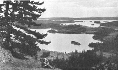
| PLATE XIII. The view across the islands as seen from the southwest slopes of the Turtleback Range. (Photograph by J. A. McCormick). |
O'NEAL ISLAND
O'Neal Island is composed largely of rocks belonging to the Orcas group. These rocks seem to have been dislocated from those occurring along the nearby shores of San Juan Island, for they trend about N 45° E and have a dip which is nearly vertical. A limestone stratum having a maximum thickness of about 20 feet crosses the southern part of the island.
Age and Correlation. In the Orcas Lime Quarry, near the foot of Orcas Knob, Sections 30 and 31, T 37 N, R 2 W, the writer discovered some fossil brachiopods on the weathered surface of the limestone ledge as it outcrops along the face of the cliff. These fossils occur to a depth of only one inch and beneath this the limestone is entirely recrystallized and shows no trace of fossil remains. Apparently this fossil-bearing ledge has been preserved in some unknown manner while the surrounding limestones have been completely recrystallized.
These brachiopods have been examined by Dr. Charles Schuchert, who determined them to be a variety of Atrypa reticularis Linneaus. He says in a letter to the writer;—
"All of them are Atrypa reticularis, one of the commonest of all Paleozoic forms. This species ranges throughout the Silurian and Devonian but your specimens look to me like the Euro-Asiatic variety seen in the late Middle and Upper Devonian throughout the west, from the Pacific to Iowa. The spirals show in a number of specimens, and these prove that their apexes turn to the center of the dorsal shells. Very few genera do this, so there is no doubt you have Atrypa reticularis, and, I think, a late Devonian form."
The Orcas group is to be correlated with the lower part of the Cache Creek series of British Columbia. The Cache Creek series was first described by Dawson5 who found in it the Pennsylvanian fossil Fusulina. He also found fossils in the lower formations, however, which ranged back into the Devonian, and he remarks that "The lower portions of the Cache Creek formation may be older than the Carboniferous period."
5Dawson, G. M., Report on Area of the Kamloops Sheet, British Columbia: Geol. Survey Canada, Ann. Rept., new ser. 7, pp. 39B-49B, 1896.
In the Bridge River district, west of Lillooet, British Columbia, McCann6, 6a describes the Bridge River series, which he considers to be of Pennsylvanian Permian age, but his description applies equally well to the rocks of the Orcas group.
6McCann., W.S., Geology and Mineral Deposits of the Bridge River Map-Area, British Columbia.
6aIbid., Memoir 130, pp. 23-26, 1922.
The Orcas group may also be partly equivalent to the Hozomeen series7 which occurs in the Skagit and Hozomeen ranges; near the forty-ninth parallel.
7Smith, G. O., and Calkins, F. C., A Geological Reconaissance Across the Cascade Range near the Forty-nineth Parallel: U. S. Geol. Survey, Bull. 235, pp. 22-23, 1904.
Deposits of chert, similar to that of the Orcas group, are known to occur in the Olympic Mountains of Washington, but as yet no detailed geological work has been done in this area.
The chert deposits in Northern California, described by Diller,8 are similar in lithology, and in addition, they contain identical fossils. Radiolarian remains are still preserved in these cherts.
8Diller, J. S., Mineral Resources of Southwestern Oregon: U. S. Geol. Survey, Bull. 546, pp. 15-16, 1914.
While the cherts of the Franciscan formation of California9, 10are tentatively referred to the Triassic or Jurassic periods, their age is not definitely known, and it may prove that they too belong to the late Devonian and Mississippian periods.
9Lawson, A. C., U. S. Geol. Survey, Geol. Atlas, San Francisco folio (no. 193), pp. 34-57, 1915.
10Davis, E. F., The Radiolarian Cherts of the Franciscan Group: Univ. Calif. Publ. Bull. Dept. Geol., vol. 11, pp. 353-408, 1918.
The limestone ledges exposed on Orcas Island, to the south of Mount Woolard, in Sec. 2, T 36 N, R 2 W, are structurally near the top of the chert group. These limestones contain the Carboniferous coral Lithostrotion.
The argillites and graywackes of the Leech River group in this area contain fragments of the "spotted" chert, and also include Fusulina-bearing limestones, hence it is probable that the Lithostrotion-bearing limestones are of Mississippian age.
The Orcas group, therefore, had its beginning in the Middle or Upper Devonian, and the deposition of its sediments continued on into the Lower Carboniferous.
PENNSYLVANIAN-PERMIAN SYSTEMS
LEECH RIVER GROUP
Principal Features. The Leech River group11, 12 is well represented in the rocks outcropping on the San Juan Island map-area. It forms the central part of the syncline on San Juan Island, and is well exposed on Lopez Island and other islands in the eastern portion of the map-area. It outcrops in many places on Orcas Island, and forms the south or mountainous half of Lummi Island. On the mainland to the east, the rocks belonging to the Leech River group outcrop at the south end of Chuckanut Drive, on the Pacific Highway.
11Dawson, G. M., Report on a Reconaissance of Leech River and Vicinity: Geol. Survey Canada, Report of Progress, 1876-77, pp. 95-102, 1878.
12Clapp, C. H., Southern Vancouver Island: Geol. Survey Canada, Mem. 13, p. 35, 1912.
The Leech River group is composed of a great variety of rock types. It contains graywacke, argillite, conglomerate and breccia, grit, schist, phyllite, slate, volcanic tuff, chert, limestone, and coal.
On the southern part of Vancouver Island, Clapp13 distinguishes a group of metamorphosed "argillaceous and arenaceous sedimentary rocks," as the Leech River "formation.". Overlying the Leech River sediments and grading into them, he describes a group of tuffaceous rocks which are known as the Malahat volcanics.
13Clapp, C. H., Sooke and Duncan Map-Areas, Vancouver Island: Geol. Survey Canada, Mem. 96, pp. 66-93, 1917.
On the San Juan Islands it is not possible to make such a sub-division, and on account of the wide range of rock types presented, it has been considered advisable to use the name, Leech River "group." Volcanic tuffs occur interbedded with the purely sedimentary strata at several horizons within the group. So far as lithology is concerned, the Malahat volcanics occurring on Southern Vancouver Island are identical with the tuffaceous graywackes which form the basal member of the Leech River group in the San Juan Island map-area.
Lithology and Structure. The dark colored slaty schists and argillites are perhaps the most abundant rock types occurring in the Leech River group. They range from quartz-mica schists and phyllites to normal slates and argillites. Quartz-biotite and quartz-sericite schists and phyllites are abundant in the eastern part of the map-area. These rocks usually contain considerable amounts of magnetite and graphite. When the percentage of carbonaceous matter is high the rocks are almost black in color when viewed from a distance.
The slates and argillites exhibit several stages of metamorphism and they are often somewhat schistose. They often alternate with massive beds of graywacke which is sometimes tuffaceous. The graywackes range from fine-grained rooks to coarse grits and are usually well cemented. They often contain rounded or nodular mudstone inclusions scattered irregularly through the coarser-grained deposits. Fragments of chert derived from the Orcas group form the most abundant constituent of the rocks of the Leech River group. Both orthoclase and plagioclase (about Ab 70 An30) are usually present in the sediments, but the percentage of quartz is below the typical amount for such rocks. Sericite, chlorite, epidote, serpentine, kaolinite, magnetite, and graphite occur in varying amounts. It is noticeable that the conglomerates are practically free from pebbles of granite, though fragments of granite porphyry and andesite are fairly common. In many localities the sediments of the Leech River group have been cut by dikes and stringers of white milky quartz.
SAN JUAN ISLAND
The lowest member of the Leech River group, as exposed on San Juan Island, is a tuffaceous and cherty graywacke. It overlies the Orcas cherts with approximate conformity. This graywacke is typically fine-grained and occurs in beds of varying thickness. In places it appears as thin beds which differ from each other only in the size of the fragments composing them. Occasionally the graywacke contains scattered layers of chert, and it is possible that the conditions which brought about the deposition of the Orcas cherts continued on, and additional sediments, including tuffaceous material, were added to them. The basal graywackes have a probable maximum thickness of several thousand feet. They have the general composition of a dacite, and their weathered surfaces are almost indistinguishable from that of a weathered andesite in the hand specimen.
The basal graywackes outcrop throughout the elevated region in the vicinity of Point Caution, and on account of their resistance to erosion, the outcrops form a series of elevated ridges. Since the rocks of both the Orcas and Leech River groups are embraced in the broad open synclinal fold which plunges towards the southeast, the individual rook formations outcrop in the form of a horseshoe. The elevated ridges representing the outcrops of the basal graywackes consequently have the shape of a horseshoe. They are seen on Biological Hill, the San Juan Range, Mount Grant, and on Little Mountain. The upper limit of the graywackes is marked by a well defined formation about 100 feet thick, composed of coarse breccia and conglomerate. This formation underlies a portion of the village of Friday Harbor and is encountered at several localities near the southwestern side of San Juan Island.
The breccia formation is followed by several hundred feet of carbonaceous argillite which has no banding or apparent structure of any kind. This is followed by a tremendous thickness of thin-bedded alternating light and dark layers of argillite which often grades into phyllite. Occasionally there are interbeds of graywacke, grit, or conglomerate.
The uppermost strata of the group are composed of thick conglomerate, grit, graywacke, and slate, and it is possible that these formations belong to the early Mesozoic systems. These upper formations occupy the core of the major plunging synclinal fold on Lopez Island and do not outcrop on San Juan Island.
In addition to the igneous intrustions which have almost everywhere penetrated the rooks of the Leech River group, these rocks are frequently cut by stringers and veins of white milky quartz.
BROWN ISLAND
Brown Island is composed of the basal graywackes of the Leech River group. These rocks have been intruded by dikes and sills of the Eagle Cliff porphyrite, and in places the sedimentary rocks have been overturned so that they dip towards the northward.
TURN ISLAND
The tuffaceous graywacke composing Turn Island has been largely destroyed by intrusions of the Eagle Cliff porphyrite. The igneous rooks now make up the greater part of the island.
DINNER ISLAND
Dinner Island is composed of thin-bedded graywacke which trends northwesterly and dips towards the southwest.
GOOSE ISLAND
Goose Island, and also the rocky peninsula to the north of Cattle Point on San Juan Island, are composed largely of graywacke which has been intruded by dikes and sills of the Eagle Cliff porphyrite. The rocks have an average strike of about N 55° W, and they dip towards the northeast at angles varying from 35 to 65 degrees.
LOPEZ ISLAND
A great thickness of alternating beds of light and dark colored argillite occurs along the south margin of Lopez Island. The individual layers of argillite are from one to three inches thick. The dark layers contain notable quantities of graphite and this gives the rocks a dark sooty appearance. In places the argillites grade into mica schists and phyllites, and they sometimes contain interbeds of graywacke, grit, and conglomerate. These sedimentary rocks have been intruded by dikes and sills of the Eagle Cliff porphyrite and they are generally somewhat silicified near the contacts.
In the vicinity of Iceberg Point, the Leech River sediments trend about N 65° W and dip towards the northeast at angles varying between 40 and 70 degrees. Between Davis Bay and the boat-landing at Richardson, the rocks have an average strike of about N 55° W, and they dip towards the northeast at an angle of about 70 degrees.
The rocks occurring in the vicinity of Point Davis are composed of argillite, slate, graywacke, and conglomerate. At Point Davis they strike N 40° W and dip towards the northeast at an angle of 35 degrees. Along the shore of Cattle Point Narrows, about opposite Deadman Island, the rocks have a strike of N 35° W and a dip of 35 degrees towards the northeast. At the most northern of these outcrops, which occur along the shore about a mile to the north of Point Davis, the strike is N 10° E, and the dip is 35 degrees towards the southeast. Still farther northward on Shark Reef the rocks trend about north and south and dip towards the east at angles varying between 15 and 20 degrees. The bend in the strike of the rock formations to the north of Point Davis is quite evident when viewed from the westward.
The outcrops of graywacke and thin-bedded argillite occurring in the vicinity of Fishermans Bay have an average strike of about N 40° E and a dip of about 40 degrees towards the southeast.
The rocky peninsula which extends out from the north end of Lopez Island to form Upright Head is composed largely of conglomerate with minor amounts of graywacke. These rocks strike about N 20°-40° W and dip about 35° NE.
The rocks composing Humphreys Head consist of massive beds of graywacke and grit which contain scattered irregular nodules of black mudstone. These beds strike about N 10°-40° W and the average dip is about 45 degrees towards the northeast.
Near the southeast corner of Hunter Bay an outcrop of thin-bedded slate, argillite, and graywacke shows a strike of N 55° W and a dip of 60° N.E. At the southeast side of Mud Bay some thin-bedded graywackes show a strike of N 52° W and a dip of 42° NE.
In the vicinity of Watmough Bight the Leech River sediments have an average strike of N 55° E and a dip of about 70° NW. At Watmough Head the strike is nearly east and west and the thin-bedded and somewhat schistose rooks dip steeply to the northward.
The rook outcrops occurring in the interior portions of Lopez Island are composed mainly of the Eagle Cliff porphyrites, and the scattered remnants of Leech River sediments are of little value in determining the structure.
DEADMAN ISLAND
The graywacke and grit which compose Deadman Island strike about N 65°-70° W and dip about 60° NE.
WHALE ROCKS
Whale Rocks are composed of fine-grained argillaceous graywacke which has a reddish color. These rocks have little or no banding but their general strike appears to be about N 40°-45° E and the dip is about 30° SE.
MUMMY ROCKS
Mummy Rocks are composed of graywacke and grit with occasional beds or pockets of argillite. In places the rocks are cut by quartz stringers. The beds strike N 60° W and dip 45° NE.
BUCK ISLAND
Buck Island is composed of graywacke which has been badly shattered by intrusions of Eagle Cliff porphyrites.
LONG ISLAND
Long Island is composed of conglomerate, grit, massive graywacke, thin-bedded argillaceous graywacke, and thin-bedded schistose argillites and slates. At the west end of the island the strike is N 40°-45° W and the dip is 35° NE. The central and eastern parts of the island have a strike of N 75° W and a dip of about 65° NE. The small islands to the south of the central part of Long Island, and tied to it by means of low sand bars, are composed chiefly of thin-bedded shaly argillites and graywackes.
CHARLES ISLAND
Charles Island is composed chiefly of thin-bedded alternating light and dark layers of somewhat schistose slates and argillites. The predominating dark color of these rocks is caused by their relatively high content of carbonaceous matter which gives them a dull sooty appearance when viewed from a distance. Interbeds of conglomerate, grit, and graywacke also occur on Charles Island. The strike of the beds varies from N 70° W to N 80° W, and the dip ranges from 60 to 75 degrees towards the northeast. The small rocky islands to the northeast of Charles Island are composed of carbonaceous slaty schists which have similar strikes and dips.
SECAR ROCK
The graywacke composing Secar Rock has been so greatly shattered by igneous intrusions that the structure is not in evidence.
HALL ISLAND
Hall Island is composed of thin-bedded graywacke and argillite which strike N 70° W and dip from 50° to 70° N.E.
ICEBERG ISLAND
The massive graywacke composing Iceberg Island has been intruded and shattered by Eagle Cliff porphyrites.
ALECK ROCKS
The thin-bedded carbonaceous slaty schists composing Aleck Rocks trend about N 75° W and dip steeply towards the northeast.
COLVILLE ISLAND
Colville Island is composed of thin-bedded carbonaceous slaty schists and graywackes with occasional beds of grit and conglomerate. The strata trend about east and west and the average dip is about 55 degrees towards the north.
BOULDER ISLAND
With the exception of a thin remnant of Leech River sediments extending out from its southern margin, Boulder Island is composed entirely of Eagle Cliff porphyrites. The Leech River sediments dip steeply towards the north.
CRAB ROCKS
The Leech River sediments composing Crab Rooks trend northeasterly and dip towards the southeast. At the end of the nearby peninsula on Lopez Island the strike is northwesterly and the rocks dip towards the northeast.
RAM ISLANDS
Although Ram Islands are composed largely of Eagle Cliff porphyrites, a sufficient amount of the host rocks have been left to show that the strike is parallel to the long direction of the islands, and the dip is about 20 degrees towards the southeast.
CENTER ISLAND
The thin-bedded carbonaceous slate, graywacke, and grit composing Center Island have a strike of about N 18° E and a dip of about 25° SE at the southern end of the island. At the northern part of the island the strike is about N 25°-30° W and the dip is about 30°-40° NE.
TRUMP ISLAND
Trump Island is composed chiefly of thin-bedded slate, argillite, and graywacke. In places these rocks weather to a bright red color. The elevated region along the east side of Trump Island is composed of massive graywacke. The rocks on Trump Island have a strike of about N 20° W and a dip of 45° NE.
DECATUR ISLAND
The massive graywacke, grit, and argillite which compose the elevated peninsula to the north of Trump Island strike about N 5° W and dip steeply towards the southwest.
The northern and elevated portion of Decatur Island is composed largely of massive and thin-bedded graywacke together with a considerable amount of conglomerate, grit, and argillite. In places these rocks have been shattered by igneous intrusions. The conglomerates at the northwest corner of the island strike about N 55° E and dip about 70° SE.
The thick and thin-bedded graywacke, grit, slate, and argillite occurring in the vicinity of Fauntleroy Point have a strike of about N 75° E and dip towards the northwest at an angle of 75 degrees.
The rounded and elevated dome which forms Decatur Head is composed of conglomerate with occasional interbeds of argillite, graywacke, and grit. The strike of these rocks is about N 80°-85° E, and the dip is about 45° NW.
An outcrop of carbonaceous thin-bedded argillite occurs on the west side of the elevated peninsula which forms the southern extremity of Decatur Island. The Leech River sediments occur as a narrow belt near the water's edge, while higher on the cliff and throughout the remainder of the peninsula the Leech River rooks have been practically destroyed by intrusions of Eagle Cliff porphyrite. The sediments occupy the crest of an anticlinal fold which plunges towards the east. At the northern end of these curved beds the strike is N 45° W and the dip is 40° N.E.
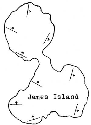
JAMES ISLAND
James Island is composed of conglomerate, shale, argillite, graywacke, and grit which have been intruded by one or two dikes of igneous material. The structure, as shown in the figure, is very complicated.
|
| Figure 2. Outline map of James Island |
Some of the rocks occurring on James Island are much less metamorphosed than the usual Leech River sediments, and it is possible that they should be correlated with the Haro formation.
FLOWER ISLAND
Flower Island is composed of massive graywacke, grit, and conglomerate which have been considerably broken by folding. The strike and dip varies in different parts of the island, but in general the trend is about north and south and the dip averages around 60 degrees towards the west. The dip and strike at different parts of this island show a remarkable discordance with each other.
SHAW ISLAND
The Leech River sediments occurring on Shaw Island consist chiefly of the basal graywacke member. The rocks in this region are badly shattered and broken, and they contain in-folded and in-faulted fragments and blocks of the Orcas chert. Intrusions of igneous material serve to make the problems in structural geology still more complicated. The same type of conditions are en countered on Canoe Island.
ORCAS ISLAND
The Leech River sediments occurring on Orcas Island to the southeast of Mount Woolard are badly shattered by intense folding and faulting. They have been involved in the minor folding or crumpling which embraces the rooks along the southern side of Orcas Island. The Orcas cherts have been faulted in with the rocks belonging to the Leech River group. The basal graywacke forms the chief representative of the Leech River group in this region, but the overlying breccia and argillite are exposed in several places.
The Orcas cherts which outcrop along the west sides of Mount Entrance and Mount Constitution Range are overlain by the graywackes of the Leech River group. On Mount Constitution Range the graywackes trend about N 35°-45° E and dip towards the southeast at moderate angles. These rocks are largely confined to the basal graywacke member though occasionally the over lying argillites may be seen.
Along the northeast shore of Orcas Island, from Point Lawrence to the foot of Buck Mountain, the Leech River sediments trend about N 60° W and dip towards the southwest at an average angle of about 60 degrees. The strata are composed of thin-bedded graywacke, shale, argillite, slate, schist, grit, conglomerate, limestone, and coal. To the north of Mount Pickett these sediments are broken up by igneous intrusions, and sills of igneous material occur occasionally at all parts of the long straight shore-line.
A series of small lens-shaped deposits of limestone occur intermittently from Raccoon Point to Point Lawrence. These limestones contain a considerable amount of carbonaceous matter and their weathered surfaces are usually black in color. They contain micro-fossils of Carboniferous age. The inner bedded graywacke, grit, and conglomerate strata are composed largely of fragments of the spotted Orcas chert together with fragments of andesite and volcanic tuff.
On the accompanying geological map of the San Juan Islands, a large area in the vicinity of Mount Pickett Range is shown in the color denoting the Turtleback complex. It would have been just as logical to have shown this whole area in the color denoting the rocks of the Leech River group. The former color was adopted for two reasons: (1) The Leech River sediments are badly broken up by igneous intrusions of several kinds; (2) The structure of the rocks in this region would not be well indicated if the whole area were shown as one color. Apparently Mount Pickett Range is located on the axis of a synclinal fold. The southern limb of this fold is largely obliterated by igneous intrusions.
The rocks belonging to the Orcas and Leech River groups on Mount Constitution Range are clearly overthrust upon the Leech River sediments to the northward. The strike of the latter is nearly at right angles to that of the former, and the break or fault line between them is clearly evident. On the east side of the range the fault line is occupied by Mountain Lake.
A fault which apparently has a considerable magnitude extends through the island, following the valley connecting the villages of Olga and Doe Bay. To the southeast of this fault line only the uppermost members of the Leech River group are to he seen, and these are free from igneous intrusions. In general these rocks trend northeasterly and dip towards the southeast. In the vicinity of Obstruction Pass the Leech River graywackes, slates, and conglomerates occur in gently undulating folds. Near its southwest entrance Obstruction Pass occupies the axis of a synclinal fold, while farther eastward it follows the axis of an anticlinal fold.

|
| PLATE XIV. Above: Looking northwestward from the slopes of Mount Constitution. East Sound in the center; Canadian islands in the right background. Below: Honyecomb sandstone on the Sucia Islands. |
OBSTRUCTION ISLAND
The graywacke, slate and grit found on Obstruction Island occur in gently undulating folds. At the eastern corner of the island an anticlinal fold plunges towards the eastward at a gentle angle. At the southwest corner of Obstruction Island the strike is about N 45°-50° E, and the dip is about 25° SE.
BLAKELEY ISLAND
The only outcrops of Leech River sediments occurring on Blakeley Island are located on the rocky peninsula which forms its northern extremity. This peninsula is composed largely of conglomerate which appears to be identical with that occurring at Upright Head on Lopez Island. The conglomerates and their interbedded graywackes and slates occurring on Blakeley Island strike about N 60° E and dip about 60° SE.
DOE ISLAND
The thick and thin-bedded argillite and graywacke occurring on Doe Island trend about N 70° E and dip towards the southeast at a gentle angle. These rocks are badly broken up by intrusions of the Eagle Cliff porphyrites.
PEAPOD ROCKS
Peapod Rocks are composed of graywacke, grit, conglomerate, and slate which trend northeasterly and dip towards the southeast. The rocks apparently belong to approximately the same horizons as those occurring in the vicinity of Obstruction Island.
STRAWBERRY ISLAND
The Leech River sediments which compose Strawberry Island, consist of thick-and thin-bedded carbonaceous argillite and graywacke. These rocks trend nearly north and south and the dips are almost vertical. The general dip is slightly towards the eastward.
CYPRESS ISLAND
Sedimentary rocks belonging to the Leech River group occur only at the northern extremity of Cypress Island. They consist chiefly of thin-bedded and dark-colored carbonaceous argillites, slates, and graywackes. Along the shore to the northwest of Eagle Cliff the rocks strike N 70° E and dip 30° SE. To the northeast of Eagle Cliff the Leech River sediments strike N 60°-75° W, and the dip varies from 25 to 55 degrees towards the southwest. The rooks have been considerably distorted by intrusions of the Eagle Cliff porphyrites. To the north of Eagle Harbor a remnant of the Leech River sediments shows a strike of N 60° E and a dip of 60° SE.
TOWHEAD ISLAND
Towhead Island is composed chiefly of dark-colored thin-bedded argillites and slates which strike N 70° E and dip 40° SE.
CONE ISLANDS
Cone Islands are composed of dark-colored thin-bedded schistose argillites and slates which have been intruded by Eagle Cliff porphyrites. One of the more northern islands of the Cone group shows a strike of N 70° E and a dip of 35° S.E. Another one of the islands shows a strike of N 55° E and a dip of 65° S.E.
SINCLAIR ISLAND
The conglomerate, grit, graywacke, and slate occurring along the southern margin of Sinclair Island apparently being the same general horizons as those found in the vicinity of Obstruction Island. The rocks occurring on Sinclair Island have a persistent strike of N 70° E, and the dip varies between 35 and 60 degrees towards the southeast.
LUMMI ISLAND
The southeastern and elevated half of Lummi Island is composed of dark-colored and usually thin-bedded argillite, graywacke, slate, grit, and conglomerate belonging to the Leech River group. These rocks have an average strike of N 40° W and an average dip of 40° NE. At Carter Point the rocks strike N 35° W and dip 40° NE. On Lummi Rocks and along the shore of Lummi Island to the eastward, the strike is N 40°-45° W and the dip is 35° NE. At the northern end of the elevated portion of Lummi Island the strike of the rock formations turns towards the westward. The most northernmost crop along the west side of the island has a strike of N 50°-65° W and a dip of 40°-50° N.E.
Along the east or dip-slope side of Lummi Island the dips and strikes are not consistent. This is due to the fact that in places the slaty rocks bay slipped down the dip-slopes. A few scattered dikes of the Eagle Cliff porphyrites may be seen in this region.
VITI ROCKS
The graywacke and grit composing Viti Rocks strike N 55° W and dip 55° SW. An apparent anticlinal fold occurs between Viti Rocks and the south end of Lummi Island.
ELIZA ISLAND
The dark-colored schistose slates and graywackes occurring at the western extremity of Eliza Island strike north and south and dip at an angle of about 50 degrees towards the east. The rocks occurring at the southern extremity of Eliza Island, and also on Eliza Rock, strike about N 10° E and dip about 10°-25° SE.
JACK ISLAND
Jack Island is composed of silvery-gray phyllite, schist, slate, graywacke, and grit. These rocks are out by numerous veins and stringers of white quartz. At the northern end of the island the strike is N 65° W and the dip is 32° SW. At the southern extremity of Jack Island, the strike is N 75° W and the dip is 30° SW.
SAMISH ISLAND
The schistose slates and graywackes occurring near the western extremity of Samish Island are somewhat carbonaceous, though they possess a silver-gray lustre. The most northern of these outcrops has a strike of N 60°-85° E and a dip of 75°-80° SE. At William Point the strike is N 45° W and the dip is 35° SW. All of these rocks are cut by numerous stringers of quartz.
GUEMES ISLAND
Along the south shore of Guemes Island, near the southeast corner, the thin-bedded carbonaceous and somewhat schistose slates and graywackes strike about N 60° W to N 75° E, and dip towards the south at an angle of about 70 degrees. Immediately north of Boat Harbor the strike of the thin-bedded slaty rocks is N 45° W and the dip is about 80° NE.
The sedimentary rocks belonging to the Leech River group on Guemes Island are so greatly shattered and broken up by igneous intrusions of several periods that the structural features shown by the remnants are not very reliable.
FIDALGO ISLAND
The somewhat carbonaceous graywacke, grit, slate, conglomerate, and argillite occurring on Capsante Peninsula and underlying the City of Anacortes strike about N 20° W and dip about 70°-85° SW.
Age and Correlation. The Leech River group is for the most part of fresh or brackish water origin and virtually unfossiliferous. At intervals the marine waters came in for a sufficient length of time to deposit an occasional limestone bed. The weathered surfaces of these limestones are always covered with a layer of black carbonaceous matter apparently derived from the limestones themselves.
The limestones are usually recrystallized but along the shore of Orcas Island, to the north of Mount Constitution Range, some of them contain micro-fossils in abundance. Among these fossils the foraminifer, Fusulina, is perhaps the most abundant. Some of the beds are composed largely of small fragments of corals and other larger fossils, together with scattered specimens of Fusulina.
Fusulina reached its period of maximum development in the Pennsylvanian time. Since the deposition of the Orcas group of sediments continued on into the Mississippian, the sediments belonging to the Leech River group are probably to a large extent of Pennsylvanian age. The fossil-bearing limestones are probably located several thousand feet above the base of the Leech River group, with several distinct types of lithology intervening. It is probable that the lower members of the Leech River group are Mississippian in age, and that the uppermost members are of Permian and possibly Triassic age.
In the Skagit and Hozomeen ranges of Washington the upper part of the Hozomeen series14 is to be correlated with the Leech River group. The Cache Creek series of central and northern British Columbia, which is apparently equivalent to the San Juan series, is argillaceous in its upper members and also contains Fusulina-bearing limestones scattered through it. At the International boundary between Washington and British Columbia a group of argillites and graywackes known as the Chilliwack series15 seems to possess the same general characteristics as the rocks of the Leech River group.
14Smith, G. O., and Calkins, F. C., A Geological Reconnaissance Across the Cascade Range near the Forty-ninth Parallel: U. S. Geol. Survey Bull. 235, pp. 22-23, 1904.
15Daly, R. A., Geology of the North American Cordillera at the Forty-ninth Parallel: Geol. Survey Canada, Mem. 38, pp. 508-516, 1912.
The Leech River sediments occurring at the type locality on southern Vancouver Island are identical in lithology with those found in the San Juan Island map-area.
It is possible that some of the argillaceous rocks occurring in the central elevated portion of the Olympic Mountains are to be correlated with the rocks of the Leech River group.
| <<< Previous | <<< Contents >>> | Next >>> |
state/wa/uw-1927-2/sec2.htm
Last Updated: 28-Mar-2006