
|
Geological Survey Water-Supply Paper 1475-F
Ground Water at Grant Village Site Yellowstone National Park, Wyoming |
TOPOGRAPHY AND DRAINAGE
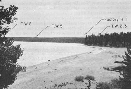
The Grant Village area is one of moderate relief. The land surface slopes generally northeastward from the Continental Divide toward Yellowstone Lake. The area is drained by the lower part of Thumb Creek and by several small unnamed intermittent streams, all of which discharge directly into the West Thumb of Yellowstone Lake. All the streams are well incised, and have cut rather deep V-shaped valleys into the sediments bordering the lake. The general topography of the Grant Village site is shown in figure 29.
|
| FIGURE 29.—View southward along the shore of the West Thumb of Yellowstone Lake toward the Grant Village site. The mouth of Thumb Creek is at right. Approximate locations of test wells 2, 3, 5, and 6 are indicated. Photograph by Ellis D. Gordon. |
The Grant Village development will be located near the lakeshore, where surface gradients are rather gentle. Along much of the lakeshore the land surface slopes rather evenly toward the shoreline, and sandy beaches have formed. Several offshore bars have developed in the vicinity of the stream inlets. In a few localities, as in the vicinity of test wells 2 and 3, wave action of the lake has cut a steep bank about 15 feet high, leaving only a narrow beach.
| <<< Previous | <<< Contents >>> | Next >>> |
wsp/1475-F/sec1.htm
Last Updated: 28-Jul-2007