
|
Geological Survey Water-Supply Paper 1475-K
Ground-Water Reconnaissance at Pinnacles National Monument, California |
GEOLOGIC AND HYDROLOGIC FEATURES
The geology of Pinnacles National Monument has been mapped and discussed in detail by Andrews (1936).1 The geology shown on plate 22 is taken predominantly from his report, except that the contacts of the alluvium have been modified and some minor changes made in the alinement of a fault.
1Andrews, Phillip, 1936, Geology of the Pinnacles National Monument: California Univ., Dept. Geol. Sci. Bull., v. 24, 38 p.
The oldest rocks in the monument area are those of the Gabilan limestone, which crops out in small patches near the western boundary and is composed of limestone, mostly metamorphosed to marble. It has been intruded by granite and granodiorite, and the intrusives are exposed over extensive areas west, south, and southeast of the monument.
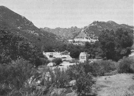
A series of massive lava flows, predominantly rhyolitic, occurs in the eastern part of the monument as a narrow belt about 1 mile wide and several miles long. In contact with these flows on the west is a similar belt of predominantly rhyolitic volcanic breccias that have been weathered to form the characteristic pinnacles (fig. 46).
|
| FIGURE 46.—View east from entrance to Pinnacles National Monument toward Bear Gulch. Characteristic pinnacles in middle skyline are rhyolitic breccias; light-colored cliff in upper middle is massive rhyolite; lower middle is alluvium of Chalone Creek; and foreground is fanglomerate of Temblor formation. Fault that parallels Chalone Creek is concealed beneath alluvium. |
In the northeastern corner of the monument the volcanic rocks are in fault contact with the Temblor formation—a sedimentary formation consisting of fanglomerate grading upward into gravel and diatomaceous shale. Recent alluvium, consisting predominantly of sand and gravel, occurs in Chalone Creek valley and in Bear Valley.
Small springs and seeps occur in fractures and along bedding planes of the volcanic flows and deposits. Along the northeast side of Chalone Creek valley, water perched in the Temblor formation is discharged from small springs and seeps.
The source of ground water in the alluvium of Chalone Creek is percolation of surface water flowing over the permeable stream-channel deposits, direct infiltration of precipitation on the alluvial deposits, subsurface inflow from tributary valleys, and possibly some subsurface inflow of water along the major northwestward-trending fault zone. Excess water from the area of springs and seeps also percolates into and recharges ground water in the alluvium of Chalone Creek.
Ground water in the alluvium is consumed by phreatophytes growing along the channel of Chalone Creek, moves as underflow down the valley, appears as a small surface flow about 200 feet upstream from the bridge where the alluvial deposits are constricted by rhyolite on both sides of the valley, and, as the valley widens downstream from the bridge, leaves the monument as ground-water outflow into Bear Valley.
| <<< Previous | <<< Contents >>> | Next >>> |
wsp/1475-K/sec2.htm
Last Updated: 28-Jul-2007