
|
Geological Survey Water-Supply Paper 1475-M
Ground-Water Resources of the Bryce Canyon National Park, Utah |
WATER RESOURCES
SURFACE WATER
In the Bryce Canyon area there are only two perennial surface streams, the East Fork of the Sevier River and the Paria River, but short perennial reaches of tributary streams are fed by springs. The diversions of water by the Tropic and East Fork Irrigation Co. from the East Fork of the Sevier River into the Paria River drainage are shown in table 1. The U.S. Geological Survey gaging station (pl. 24) was installed primarily to record the amount of water in the Tropic Ditch that crosses the divide; it does not necessarily record the total amount of water released from the Tropic Reservoir.
SPRINGS
The springs of the Bryce Canyon National Park area may conveniently be divided into two groups: those on top of the Paunsaugunt Plateau and those below the rim in the Paria River drainage area. Fluctuations in the flow of springs on top of the plateau are closely related to annual precipitation, whereas fluctuations of the flow of springs below the rim are not. On the Paunsaugunt Plateau are two types of springs—bedrock and alluvial. The bedrock springs on the plateau may, in turn, be divided into those that issue from the white beds of the Wasatch formation and those that issue from the basal conglomerate of the Wasatch formation.
On the plateau several bedrock springs (for example, Shaker, Trough, and Whiteman) occur on the north and east sides of Whiteman Bench (pl. 24). It is thought that these springs occur where permeable beds in the sandy white beds of the Wasatch formation lie in contact with the denser pink limestone beds of the same formation. Inasmuch as all the springs issue from thin alluvium, it is difficult to determine the bedrock source. These springs are recharged by rain and snow that falls on top and around the margins of Whiteman Bench; the yields are unstable and fluctuate in response to variations in the amount and distribution of precipitation. In May 1957 Shaker, Trough, and Whiteman Springs were not flowing. The upper graph in figure 52 shows that in 1956 the cumulative departure from normal precipitation was at the lowest point during the period of record, which probably accounts for the cessation of flow from the bedrock springs on the plateau.
Above the Tropic Reservoir on the plateau are several springs that contribute water to short tributaries of the East Fork (pl. 24). The geologic map (fig. 55) shows that these springs issue from the Wasatch formation just above its contact with the underlying Kaiparowits formation. Gregory (1951, p. 46) states that the basal conglomerate of the Wasatch formation is present near the Tropic Reservoir, and it is thought that the springs issue from this permeable bed. However, these springs were not visited by the writer.
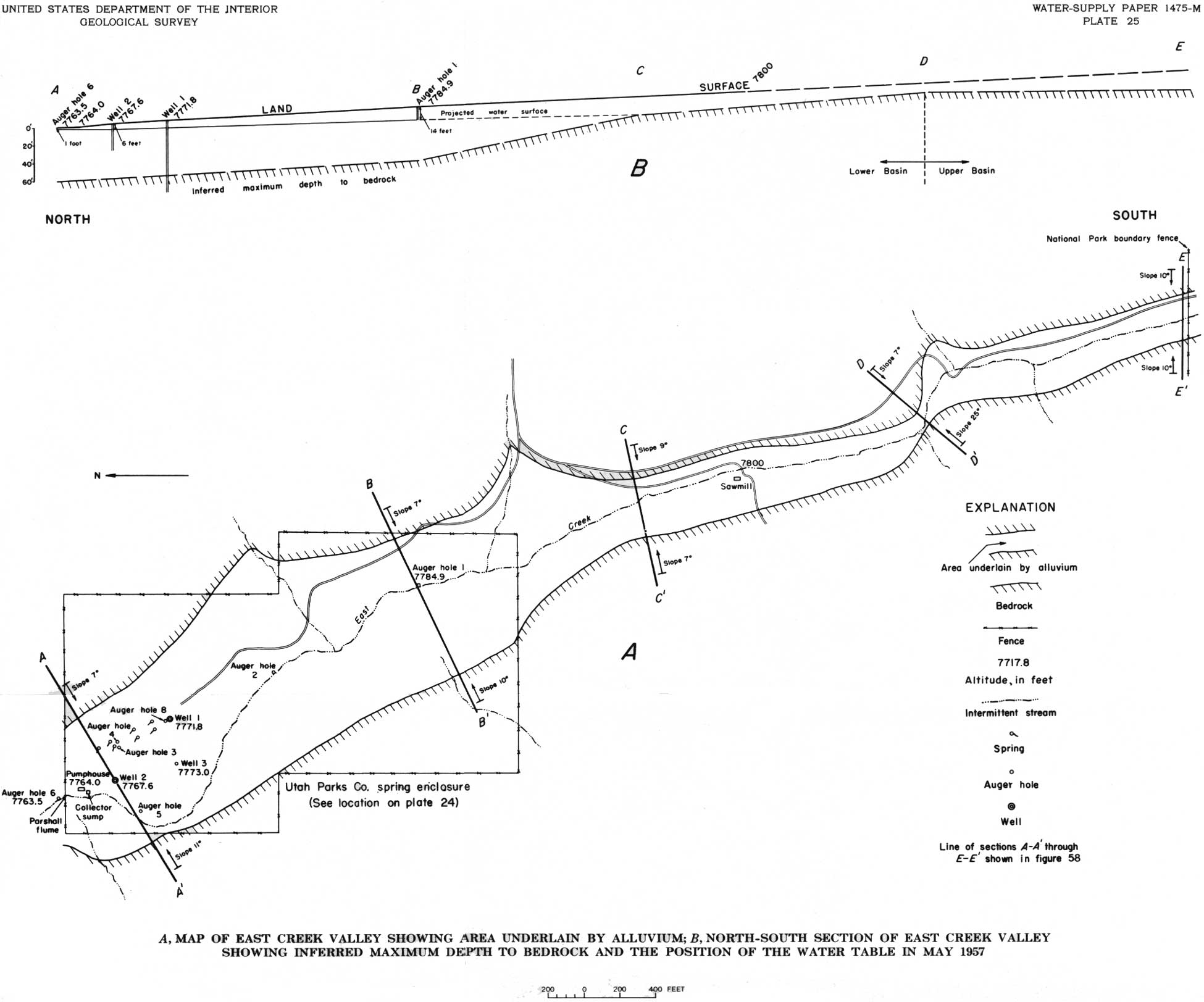
Springs on the plateau whose source is alluvium are probably present in most of the larger valleys. Seven of these springs are in East Creek valley (pl. 25), and these were the only ones visited by the writer. These springs had an insignificant flow in May 1957, and by June all flow had ceased.
|
| PLATE 25.—A, MAP OF EAST CREEK VALLEY SHOWING AREA UNDERLAIN BY ALLUVIUM; B, NORTH-SOUTH SECTION OF EAST CREEK VALLEY SHOWING INFERRRED MAXIMUM DEPTH TO BEDROCK AND THE POSITION OF THE WATER TABLE IN MAY 1957. (click on image for an enlargement in a new window) |
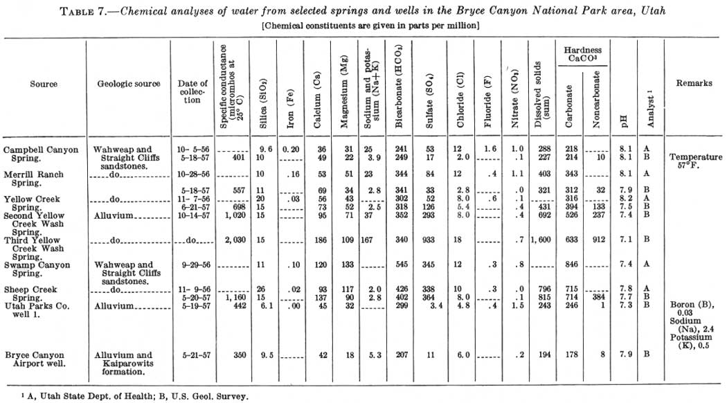
The second region of springs is below the rim in the Paria River drainage area, where springs issue from thin patches of alluvium which obscure their bedrock source. The locations of these springs are shown on plate 24, and table 6 gives their altitudes, the geologic formations from which they issue, and their respective stratigraphic positions. The geologic formations and stratigraphic positions from which these springs issue were determined from Gregory's geologic map (1951). Table 7 gives chemical analyses of water collected from selected springs.
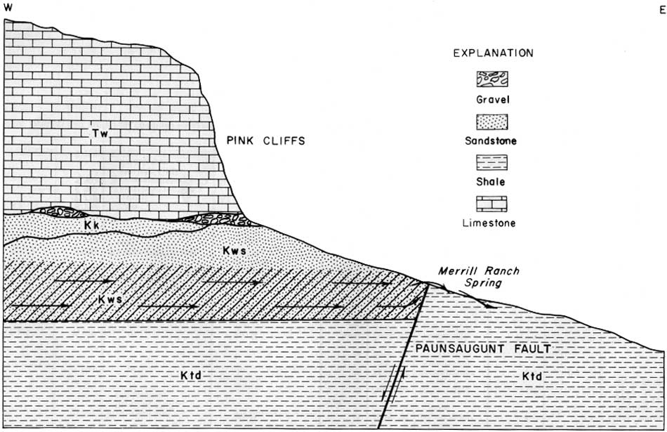
Springs and seeps occur at many localities in the foothills below the rim on the east side of the Paunsaugunt Plateau. These are caused by the eastward and northeastward movement of water as it follows the dip of the more permeable beds. Sheep Creek, Swamp Canyon, Yellow Creek Springs, and the springs farther south along the rim are examples of springs that owe their existence to the outcrop of permeable beds. Merrill Ranch, Bryce, and Campbell Canyon Springs are faultline springs. Figure 56 illustrates the mode of occurrence of most faultline springs in this area. The upthrown block of Tropic shale forms a relatively impervious eastern barrier which forces water from the permeable beds in the Wahweap and Straight Cliffs sandstones to rise to the surface instead of continuing its northeastward movement.
|
| FIGURE 56.—Generalized east-west cross section through Merrill Ranch Spring showing the movement of ground water in relation to the occurrence of all faultline springs in the area. Double-barbed arrows represent direction of water movement; crosshatched area represents zone of saturation. Tw, Wasatch formation; Kk, Kaiparowits formation; Kws, Wahweap and Straight Cliffs sandstones, undifferentiated; Ktd, Tropic shale and Dakota sandstone, undifferentiated. (click on image for an enlargement in a new window) |
Nearly all the springs below the rim issue from alluvium, which in some places is a thin layer obscuring the bedrock. The water emerging from these springs has a constancy of flow that indicates a bedrock source. If their source were the alluvium in the reentrants these springs probably would not flow in dry seasons as the alluvium generally is insufficient to store enough water to support the flow, except in wet weather. The recharge area of these springs is restricted to the Paunsaugunt Plateau and immediately adjacent areas. Formations below the Wahweap and Straight Cliffs sandstones probably obtain part of their recharge from areas more distant than the plateau.
Table 6 gives the measured discharge of the springs below the rim in the Bryce Canyon area. Because the conditions at each spring are different, each will be considered separately with respect to its utilization for water supply. Springs north of Campbell Canyon were not visited by the writer, and no measurements of flow or chemical analyses are available.
TABLE 6.—Records of springs below the Pink Cliffs in the Bryce Canyon National Park area, Utah
| Name of spring1 | Altitude (ft) |
Geologic source | Stratigraphic position | Discharge (gpm) |
Date (1957) |
Method of measurement |
Total lift to Utah Parks Co. tanks2 (ft) |
Approximate direct distance to Utah Parks storage tanks (miles) | Remarks |
| Above base: | |||||||||
| Upper East Fork (tributary to Cope Canyon) | 7,100 | Wasatch formation | 300 ft | -- | -- | -- | 1,020 | 6.9 | Location of spring reported by local residents; not visited by writer. |
| Lower East Fork (tributary to Cope Canyon) | 6,900 | do | 100 ft | -- | -- | -- | 1,220 | 6.5 | Do. |
| Cope Canyon | 6,950 | do | 150 ft | -- | -- | -- | 1,170 | 6.3 | Do. |
| Water Canyon | 7,000 | do | 320 ft | -- | -- | -- | 1,120 | 4.4 | Do. |
| Mossy Cave | 7,250 | do | 570 ft | -- | -- | -- | 870 | 4.3 | Do. |
| Below top, at Paunsaugunt fault: |
|||||||||
| Campbell Canyon | 6,800 | Wahweap and Straight Cliffs sandstones. | 200 ft | 17 | May 18 | Rectangular weir. | 1,320 | 3.0 | |
| 28 | Sept. 24 | 90° V-notch weir. | -- | -- | |||||
| Bryce | 6,900 | do | 350 ft | -- | -- | -- | 1,220 | 2.3 | |
| Merrill Ranch | 6,900 | do | 550 ft | 17 | May 18 | Rectangular weir. | 1,220 | 3.0 | |
| 12 | June 21 | Cipolletti weir. | -- | -- | |||||
| 24 | Sept. 25 | 90° V-notch weir. | -- | -- | |||||
| Below top: | |||||||||
| Yellow Creek | 7,220 | do | 100 ft | 81 | May 15 | Cipolletti weir. | 900 | 2.1 | |
| 43 | June 21 | do | -- | -- | |||||
| 52 | Sept. 25 | 90° V-notch weir. | -- | -- | |||||
| Upper Yellow Creek Wash | 7,220 | do | do | 120 | May 15 | Float | 900 | 2.1 | Total water available at Upper Yellow Creek: May 15, 201 gpm; June 21, 193 gpm; Sept. 25, 172 gpm. |
| 140 | June 21 | do | -- | -- | |||||
| 120 | Sept. 25 | do | -- | -- | |||||
| Second Yellow Creek Wash | 6,900 | do | 400 ft | 185 | June 21 | do | 1,220 | 2.9 | |
| Right Fork (of Yellow Creek) | 7,220 | do | 100 ft | 75 | June 21 | do | 900 | 2.1 | Location of spring reported by local residents; not visited by writer. Discharge measured 1 mile downstream from reported source. |
| Third Yellow Creek Wash | 5,800 | Winsor formation | 600 ft | 60 | Sept. 25 | Visual estimate. | -- | -- | |
| Swamp Canyon | 7,270 | Wahweap and Straight Cliffs sandstones. | 200 ft | 11 | May 20 | Rectangular weir. | 870 | 3.4 | Total water available at junction of Sheep Creek and Swamp Canyon: May 20, 59 gpm; Sept. 24, 36 gpm. |
| 2 | Sept. 24 | 90° V-notch weir. | -- | -- | |||||
| Sheep Creek | 7,270 | do | do | 48 | May 20 | Rectangular weir. | 870 | do | |
| 34 | Sept. 24 | 90° V-notch weir. | -- | -- | |||||
| Second Sheep Creek | 7,120 | do | 350 ft | Seep; no flow. | Sept. 24 | Visual estimate. | 1,000 | 4.0 | |
| Natural Bridge | 8,200 | Wasatch formation | At base | -- | -- | -- | -- | -- | Spring seen from rim and plotted on map, hut not visited by writer. |
| Agua Canyon | 8,250 | do | do | -- | -- | -- | -- | -- | Do. |
| Ponderosa Canyon | 8,100 | do | do | -- | -- | -- | -- | -- | Do. |
| Above base: | |||||||||
| Iron | 8,050 | Kaiparowits formation. | 250 ft | -- | -- | -- | -- | -- | Spring shown on 1939 U.S. Geological Survey topographic map. Neither seen nor visited by writer. |
| Birch | 8,100 | do | 350 ft | -- | -- | -- | -- | -- | Do. |
| Lonely | 7,775 | do | At base | -- | -- | -- | -- | -- | Do. |
| Yovimpa | 8,360 | Wasatch formation | do | -- | -- | -- | -- | -- | Do. |
| Riggs | 7,500 | Wahweap and Straight Cliffs sandstones. | Below top sandstone, 400 ft. | -- | -- | -- | -- | -- | Do. |
| Gravel | 7,750 | do | Below top, 150 ft | -- | -- | -- | -- | -- | Do. |
2Altitude of storage tanks (8,120) interpolated from topographic map.
Campbell Canyon Spring is within the National Park boundary and is 3 miles from the storage tanks of the Utah Parks Co. Water rises in a grassy marsh between two washes that join just below the spring. The water drops about 10 feet from the grassy area to the gravel in the stream wash proper. Within 300 feet of the point where the spring water flows onto the gravel of the Wash, all surface water has disappeared. Development work might increase the yield of this spring slightly (table 3). The water is hard but otherwise of good quality (table 7), and, like that of other springs below the rim, the yield is fairly constant. The principal objection to the development of a water supply at this site is the low yield of the spring (table 6).
TABLE 7.—Chemical analyses of water from selected springs and
wells in the Bryce Canyon National Park area, Utah
[Chemical constituents are given in parts per million]
(click on image for an enlargement in a new window)
Bryce Spring supplies drinking and culinary water to the town of Tropic. Residents estimate that the flow is about 1 cfs (cubic foot per second); however, the flow of the spring was not measured by the writer. Gregory (1951, p. 112) said that Tropic received 38 gpm from this spring area.
Merrill Ranch Spring is 1-1/2 miles east of the Pink Cliffs along the Paunsaugunt fault (fig. 56). The water rises in a grassy area, as does that of several of the other springs, but it does not empty into a gravel-bottomed wash as it does at the others. Sandy clay is at the surface in both the source area for the spring, and at the spring. Owing to the clayey nature of the surface material at the spring, it would be difficult to increase the yield of the spring substantially by development work. The yield is small (table 6), and even a 50-percent increase would not provide enough water for the present water need of the park.
Certain of the springs in Yellow Creek offer the best possibility for the development of a water supply from a spring source. The springs in Yellow Creek (pl. 24) have been subdivided for discussion as follows: (1) Yellow Creek Spring and (2) Upper Yellow Creek Wash Spring in the upper reach of Yellow Creek; (3) a marshy area south of Yellow Creek but in the vicinity of (1) and (2); (4) Second Yellow Creek Wash Spring above the junction of Yellow Creek with North Fork; (5) Right Fork (of Yellow Creek) Spring; (6) Third Yellow Creek Wash Spring below Ott Ranch.
Water first appears in Yellow Creek at Upper Yellow Creek Wash Spring (2) and is joined a short distance downstream by water from Yellow Creek Spring (1). It flows downstream for a distance that varies with the amount of water flowing from the two springs and, with the season, but in June 1957 it was about a quarter of a mile. Below this the bed of Yellow Creek was dry for a distance of slightly less than a mile. Water appeared again in the channel at the Second Yellow Creek Wash Spring (4). In 1957 all this water was diverted into a ditch parallel to Yellow Creek that carries it to Ott Ranch (pl. 24), but, according to residents of the area, water would be visible in the bed of Yellow Creek all the way to Ott Ranch if it were not diverted. Below Ott Ranch, Yellow Creek was dry to the Third Yellow Creek Wash Spring (6).
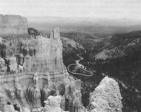
The water from the upper spring area (1 and 2) of Yellow Creek is of good chemical quality for domestic needs (table 7), and the quantity is sufficient for the park needs (table 6). An additional advantage of this source is the possibility of expansion as the need for water in the park grows. The principal disadvantage of the upper spring's source is that it is not readily accessible. The upper spring area can be seen from the Paria View observation point (fig. 57), and it might be necessary to camouflage any structures placed there, so as not to spoil the view. A pipeline to the top of the rim would be necessary for development of the upper spring area of any of the spring's sources below the rim.
Yellow Creek Spring (1) issues in a grassy marsh covering about 2 acres near the base of the Pink Cliffs. From this spring area the water drops about 10 feet into the bed of Yellow Creek, where the water flows perennially. The relative positions of Yellow Creek Spring and Yellow Creek Wash are shown in figure 57. The water in the channel first appears opposite the upper end of the spring area and probably comes from the same permeable bed in the Wahweap and Straight Cliffs sandstones that supplies the spring. On the south side of the wash is another grassy marsh (3) which suggests an additional outcrop of this permeable bed in the Wahweap and Straight Cliffs sandstones. Although this area is soggy and wet, no visible flow leaves it.
|
| FIGURE 57.—Yellow Creek Spring (circled) and Yellow Creek seen from Paria View observation point. Photograph by H. A. Waite. |
Inasmuch as the measured flow of Yellow Creek Spring (1) and Upper Yellow Creek Wash Spring (2) (table 6) represents only the water at the surface, more water probably could be obtained by proper development work at this source. A substantial part of the water flowing at the surface in the permeable wash must be sustained by underflow. Construction of a tile drain under the channel possibly would make available additional water. Any surface works constructed in the wash proper would be subject to destruction by the occasional but violent cloudburst floods that are responsible for emplacing the boulders and cobbles that make up the floor of the wash. Any construction in gravel washes should be planned with the destructive nature of these storms in mind. It is believed by the writer that the amount of surface discharge in Yellow Creek combined with the increased amount available as a result of development work would be sufficient for the park needs for a long time.
At the Second Yellow Creek Wash Spring (4) water appears in the permeable gravel of Yellow Creek Wash. Water from this point flows at the surface in an unlined ditch for more than 4 miles downstream where it is used at Ott Ranch. Water from the Right Fork (of Yellow Creek) Spring (5) disappears into the permeable gravel about 150 yards upstream from the point where the wash joins Yellow Creek. The source of this water was not seen by the writer, and the location of the spring shown on plate 24 was reported by a local resident. Farther down Yellow Creek Wash, water appears again at the Third Yellow Creek Wash Spring (6) but is of very poor chemical quality (table 7).
Table 3 shows that there is sufficient water in the upper spring area of Yellow Creek to supply the park needs. If the upper spring area is developed for a water supply, laying the pipeline for some distance northward before having it ascend the Pink Cliffs might insure that the Right Fork Spring (5) would be conveniently near the pipe lines should additional water be needed in the future.
The Sheep Creek Spring (pl. 24) rises from small amphitheaters in the alluvium of the stream. The Swamp Canyon Spring rises from a grassy marsh several acres in area. The water from Swamp Canyon Spring collects in a channel and flows for several hundred yards before it joins Sheep Creek. The yields from these two springs were measured separately a few score feet above their junction (table 6). Development work at Swamp Canyon Spring probably could increase the yield, but it is doubtful that much could be done to increase the yield of Sheep Creek Spring. The proximity of these springs and the presence of similar chemical constituents in water derived from them indicate that both springs have a common bedrock source in the Wahweap and Straight Cliffs sandstones. The high sulfate and calcium content is noteworthy and strongly suggests that abundant gypsum (CaSO4) is present in the aquifer (table 7). The high content of calcium and sulfate in this water makes it undesirable for a public water supply, although the spring area is probably the most accessible of any below the rim. These springs can be reached by jeep from the lodge and headquarters area. About 1 mile downstream from Sheep Creek Spring, on the side of a hill on the east slope of Sheep Creek valley, is a seep area called the Second Sheep Creek Spring (table 6; pl. 24). This spring issues from the Wahweap and Straight Cliffs sandstones and is unique in that alluvium does not obscure its bedrock source.
Springs south of Sheep Creek were not considered as possible sources of water for the lodge and headquarters area because of the availability of adequate water supplies nearer the area of use.
GROUND WATER IN ALLUVIUM
The area on the Paunsaugunt Plateau underlain by saturated alluvium is small compared with the area underlain by saturated bed rock. However, owing to the greater permeability of alluvium, these areas are of relatively great importance to the water resources of the region. In the Bryce Canyon area, the most significant deposits of alluvium occur beneath the valley bottoms of Emery Valley, the East Fork of the Sevier River, East Creek, Daves Hollow, and smaller tributaries to the East Fork.
EAST CREEK VALLEY
In the summer of 1957 the water supply for Bryce Canyon National Park was obtained first from one well (well 1) and later from two wells (wells 1 and 2) in East Creek valley near the alluvial springs formerly used for a water supply. To determine if the water yield of this valley were sufficient for the park needs and if the valley could support a larger development than existed in 1957, greater emphasis was placed on investigating the ground-water resources of the alluvium in this valley than was given to other bodies of alluvium. This valley is in a favorable location because it is only a little more than 2 miles from the Utah Parks Co. storage tanks and because the pumping lift is only 372 feet.
Because of the water-supply developments in East Creek valley, more information was available on the quantity and dependability of the water yield from this alluvial body than from others. Information on these developments in East Creek valley is included in the section on "Water Use."
The flow of East Creek, when not caused by cloudbursts, is controlled principally by the ground-water level in the adjacent alluvium. Springs and seeps occur only when the amount of water in the alluvium of East Creek valley is in excess of the amount required for saturation and for supplying water-using plants that are abundant in areas of high water table. When sufficient water is released to the surface, it flows down East Creek. In late summer of 1955 and in 1956 and 1957 East Creek did not flow, suggesting that the alluvium in the valley was not saturated to the extent that it had been in previous years.
The cessation of flow in East Creek was due principally to a deficiency of precipitation over a period of years. The upper graph of figure 52 shows the cumulative departure from normal precipitation at Bryce Canyon National Park for the period 1933 through 1956. According to the U.S. Weather Bureau, the normal annual precipitation at Bryce Canyon National Park is 17.34 inches. The cumulative deficiency during the period from 1947 through 1956 amounted to about 33 inches, nearly 2 years' normal supply. The effect that this deficiency of precipitation had on the amount of water stored in the alluvium in East Creek valley is not known, but it probably was substantial.
Some of the recharge to the alluvium comes from bedrock springs. Whiteman Spring, at the toe of Whiteman Bench, is tributary to East Creek, and when the spring flows it supplies some recharge to the alluvium along that stream. Fluctuations in the flow of Whiteman Spring and other bedrock springs on the Paunsaugunt Plateau probably bear a closer relation to the cumulative departure from normal precipitation than to the yearly precipitation. Whiteman Spring was dry in the summer of 1957; therefore, it contributed no recharge to the alluvium of East Creek valley. Although 1957 was a year of above-normal precipitation, several such years may be required to restore the flow of Whiteman Spring to its former normal volume.
A water-level recording gage was in operation on Utah Parks Co. well 3 from April 26, 1957, to October 23, 1957. The hydrograph of this well shows that the water level in the alluvium of East Creek valley continued to decline as long as water was being pumped from the basin, indicating that the withdrawal exceeded the recharge. This is substantiated by the reaction of the water level to intermittent pumping in May 1957. The water level recovered when the pump was turned off, but not to the original static water level.
To determine how much water is stored in the ground-water reservoir in the alluvial valley, the flat valley floor, herein considered to represent the part of the valley underlain by alluvium, was mapped (pl. 25A). The slopes of the sides of the valley also were measured at selected points. In constructing the cross sections of the valley fill, it was assumed that the slopes of the valley sides persist beneath the alluvium (fig. 58).
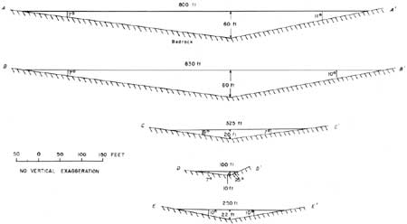
|
| FIGURE 58.—Selected schematic cross sections across East Creek valley showing approximate thickness of alluvium. The locations of the cross sections are shown on plate 25A. |
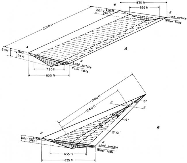
Figure 59 was constructed by combining the cross sections of figure 58 with the section of plate 25B. It is believed by the writer that the resulting geometric figures are representative of the approximate shape and dimensions of the alluvial fill.
|
| FIGURE 59.—Schematic diagrams of saturated alluvium in parts of East Creek valley, May 1957. A, segment between cross sections A—A' and B—B'; B, segment between cross sections B—B' and C—C'. Locations of cross sections are shown on plate 25A. (click on image for an enlargement in a new window) |
On the assumptions that (1) about 32 percent of the alluvium is water bearing (average in wells 1-3; table 4); (2) the specific yield (drainable pore space) of the water-bearing material is about 20 percent; and (3) the total volume of saturated alluvium is about 40 million cubic feet (volume of the parts with the ruled pattern in fig. 59, the volume of ground water in storage in the alluvium between cross sections A—A' and C—C' is estimated to be about 2.6 million cubic feet. This amount of water might be available to a well that penetrated 60 feet of alluvium, that was equipped with a pump whose bowls were set at the bottom of the Well, and that was pumped long enough. None of the wells of the Utah Parks Co. were drilled through as much as 60 feet of alluvium.
The ground-water storage available to the wells of the Utah Parks Co. may be estimated by subtracting the volume of ground water in storage below 25 feet in depth (about 1.2 million cubic feet) from the total storage in East Creek valley. The total volume of ground water available to these wells as of May 1957 thus amounted to about 1.4 million cubic feet.
In this estimate it is assumed that the water table in the alluvium could be lowered in successive stages without the formation of excessively deep cones of depression. In the late summer of 1957 the cones of depression around both the existing wells were steep, and because of this circumstance it was not possible to develop the maximum amount of water from storage.
A chemical analysis of the water from well 1 is shown in table 7. This water is of very good chemical quality, and water of comparable quality probably can be obtained from wells anywhere in the alluvium of East Creek valley.
OTHER ALLUVIUM-FILLED VALLEYS
Ground water probably occurs in the valley of the East Fork of the Sevier River under conditions very similar to those of East Creek valley. Because the drainage area of the East Fork is larger and the volume of alluvium in the valley is larger, the yield of ground water from the East Fork valley would probably be more dependable than that from East Creek valley.
Because the drainage area of Daves Hollow (about 5.4 square miles) is about half that of East Creek (11.2 sq. mi., of which about 9.3 sq. mi. is above the pumphouse), the ground-water yield would probably be less dependable than that from the alluvium of East Creek valley. The yields of wells drilled in Emery Valley are small, which suggests that the water-bearing material is not highly productive. The total ground-water storage of this valley may be large, however.
GROUND WATER IN BEDROCK
The water-bearing properties as well as the geologic characteristics of the Cenozoic and Mesozoic formations that underlie the Bryce Canyon area are shown in table 5. The principal bedrock units that might yield water to a well, from the surface down, are (1) the basal conglomerate of the Wasatch formation, (2) the Wahweap and Straight Cliffs sandstones, (3) the Dakota sandstone, (4) parts of the Winsor formation, (5) the Entrada sandstone, (6) the Navajo sandstone, and (7) the Shinarump member of the Chinle formation.
The basal conglomerate of the Wasatch formation (1) is lenticular and might be missing at any particular place. A well drilled into the basal Wasatch in the vicinity of Bryce Point, where Gregory (1951, p. 46) reported the conglomerate to be 10 to 30 feet thick, might be successful, but there is no evidence to indicate potential yields. Even if a permeable lens of coarse material were penetrated, it might not be extensive enough to yield water perennially.
The Wahweap and Straight Cliffs sandstones (2) support many springs in the area, and in the Yellow Creek vicinity these sandstones yield water in large quantity. Most of the springs issuing from the Wahweap and Straight Cliffs sandstones supply excellent drinking water, but water from Swamp Canyon and Sheep Creek Springs has a high sulfate content (table 7). It is entirely possible that a well drilled into the Wahweap and Straight Cliffs sandstones might encounter water of similarly poor quality.
The Dakota sandstone (3) is thin and for this reason would not be expected to yield large quantities of water. Because the overlying Tropic shale contains abundant gypsum, water from the Dakota sandstone probably would be high in dissolved minerals owing to seepage from above.
It is likely that water from the Winsor formation (4) also would be appreciably mineralized owing to the gypsum contained in the formation.
Water from the Entrada sandstone (5) probably is somewhat mineralized because of the abundance of gypsum in this formation, and yields would probably be small.
The Navajo sandstone (6) is 1,200 to 1,800 feet thick and perhaps thicker, and the minimum depth to the top of the formation is about 3,800 feet. Water from the Navajo sandstone might be of good quality because the sandstone is made up dominantly of quartz sand. The Navajo sandstone might yield water in sufficient quantity to supply the needs of the park.
Water from the Shinarump member of the Chinle formation (7) is probably highly mineralized in this area and could be obtained only by drilling a well 6,500 feet or more deep.
Conclusions about the quality of the water in the several formations are supported by an electric log of one oil test in the area.
If a bedrock test well is attempted, it is recommended that it be drilled to the top of the Tropic shale at a depth of about 2,000 feet, in order to test the entire section of the Wahweap and Straight Cliffs sandstones. Because these are marine sandstones, they are probably fairly uniform but relatively low in permeability under most of the area in which a deep well would be drilled. Any bedrock test well should be located as far as practical from the ground-water discharge area below the rim, and where there is a favorable opportunity to intercept fracture zones in the Wahweap and Straight Cliffs sandstones. The axis of the anticline described by Hager (1957), if extended, passes through Bryce Canyon, although the Bryce Canyon area is beyond the limits of his map. It is therefore recommended that any bedrock test well be located near the crest of this anticline so that the greatest number of tension fractures will be encountered. The location of a recommended test site is shown on plate 24.
It would seem that the chances of obtaining good water between the base of the Wahweap and Straight Cliffs sandstones and the Navajo sandstone are small. Therefore, unless it is intended to drill to the Navajo sandstone, at a depth of about 3,800 feet below the surface at the test site indicated on plate 24, there seems to be little reason to drill below the base of the Wahweap and Straight Cliffs sandstones. Several water-producing sands should be penetrated by a well drilled through the Wahweap and Straight Cliffs sandstones, but whether the yield of such a well would be sufficient for the park needs depends on the amount of fracturing in these formations.
| <<< Previous | <<< Contents >>> | Next >>> |
wsp/1475-M/sec3.htm
Last Updated: 28-Jul-2007