
|
Geological Survey Water-Supply Paper 1475-O
Hydrologic and Geologic Reconnaissance of Pinto Basin Joshua Tree National Monument, Riverside County, California |
INTRODUCTION
PURPOSE AND SCOPE OF THE INVESTIGATION
This report presents the findings of a brief geologic and ground water reconnaissance made by the U.S. Geological Survey in Pinto basin, Riverside County, Calif. The investigation was made at the request of the National Park Service to determine if the existing pattern of ground-water pumping from Pinto basin will reduce the yield of wells or impair the quality of the ground water in Pinto basin, which lies almost wholly within the Joshua Tree National Monument.
Specifically, this report presents: (1) a brief geologic reconnaissance of Pinto basin, with particular emphasis on the unconsolidated deposits and the geologic structure in the area of subsurface outflow at the southeast end of the basin; (2) information on the occurrence and movement of ground water; (3) an approximation of the ground water storage capacity of the water-bearing deposits in the east-central part of Pinto basin and the relation of the storage capacity to pumpage; and (4) data on wells, water-level records, drillers' logs of wells, pumpage from wells, and chemical analyses of ground water.
Fieldwork was done intermittently between June 1955 and December 1959. This work has been carried on by the Long Beach, Calif., subdistrict office of the U.S. Geological Survey under the general supervision of J. F. Poland, G. F. Worts, Jr., and H. D. Wilson, Jr., successive district supervisors, Sarcamento, Calif.
LOCATION OF THE AREA
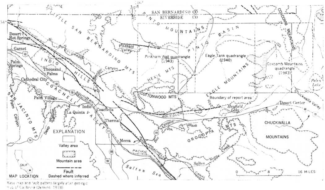
Pinto basin is in the Mojave Desert in the north-central part of Riverside County, Calif. (fig. 64). As usually applied, the term "Pinto basin" refers to the alluviated or valley-floor part of a drainage system that discharges to the south along a dry wash between the Eagle and Coxcomb Mountains. However, this investigation is concerned chiefly with the downstream part of the drainage area. Therefore, where the term "Pinto basin" is used in this report, it refers to the main valley area between 115°20' and 115°42'30" west longitude.
|
| FIGURE 64.—Map of part of southern California, showing area covered by this report. (click on image for an enlargement in a new window) |
PREVIOUS INVESTIGATIONS AND ACKNOWLEDGMENTS
The area studied (pl. 28) is shown on the Pinkham Well, Eagle Tank, and Coxcomb Mountains quadrangles (scale 1:62,500) of the U.S. Army, Corps of Engineers. The area north of lat 34° N. is shown on the Amboy quadrangle (scale 1:250,000). However, this area is not critical to the present study and has not been included as part of plate 28.
PREVIOUS INVESTIGATIONS AND ACKNOWLEDGMENTS
The mountainous region south of Pinto basin was examined by E. C. Harder (1912) during the summer of 1909 in connection with a study of the iron-ore deposits of the Eagle Mountains. The report of that study contains a reconnaissance geologic map of the Eagle Mountains showing the types and extent of the consolidated rocks, but it does not show Pinto basin.
As part of an anthropologic study, the major geologic units of the lower part of Pinto basin are briefly described in a report by Scharf (1935). That report contains several excellent panoramic photographs but no geologic map.
As part of a general hydrologic study by the National Park Service, J. V. Lewis prepared a map, showing the extent of alluvial deposits and the locations of wells and springs (written communication, 1941), and a report discussing the water resources of Joshua Tree National Monument and vicinity (written communication, 1942).
Pertinent information from these maps and reports was used in the preparation of this report.
Special thanks are due M. J. Hughes, general manager of the Eagle Mountain mine, and his staff in furnishing well logs, water-level records, chemical analyses of water, and pumpage and other data from wells in Pinto basin. These data were vital in the preparation of this report.
| <<< Previous | <<< Contents >>> | Next >>> |
wsp/1475-O/intro.htm
Last Updated: 28-Jul-2007