| |
 |
Archaeology
Introduction to the
Grand Canyon National Park
Archaeology River Monitoring Program
![[Photo of a pot half buried in sand]](image001.jpg) In July 1989 Secretary of the Interior Manuel Lujan directed Reclamation to prepare an Environmental Impact Statement (EIS) regarding the operation of the Glen Canyon Dam. Thus, more than a quarter-century after the floodgates of the dam closed, its environmental effects were to be judged scientifically. Under the National Environmental Policy Act of 1969, which authorizes the EIS process, cultural resources are an aspect of the environment worthy of study and consideration, just as are natural resources. The EIS for Glen Canyon Dam operations therefore mandated scientific studies of cultural resources within the area potentially affected by water releases. Further Glen Canyon Dam operations are considered a federal undertaking that either directly, indirectly or potentially affect cultural resources. Acknowledgement of this enacts the National Historic Preservation Act of 1992 (amended) (NHPA). Under Section 106 of this act the Bureau of Reclamation (Reclamation) is responsible for the impacts to cultural resources caused by dam operations and National Park Service (NPS) is dually responsible for these cultural resources under Section 110 of NHPA. In July 1989 Secretary of the Interior Manuel Lujan directed Reclamation to prepare an Environmental Impact Statement (EIS) regarding the operation of the Glen Canyon Dam. Thus, more than a quarter-century after the floodgates of the dam closed, its environmental effects were to be judged scientifically. Under the National Environmental Policy Act of 1969, which authorizes the EIS process, cultural resources are an aspect of the environment worthy of study and consideration, just as are natural resources. The EIS for Glen Canyon Dam operations therefore mandated scientific studies of cultural resources within the area potentially affected by water releases. Further Glen Canyon Dam operations are considered a federal undertaking that either directly, indirectly or potentially affect cultural resources. Acknowledgement of this enacts the National Historic Preservation Act of 1992 (amended) (NHPA). Under Section 106 of this act the Bureau of Reclamation (Reclamation) is responsible for the impacts to cultural resources caused by dam operations and National Park Service (NPS) is dually responsible for these cultural resources under Section 110 of NHPA.
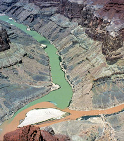
![[Section of the Colorado River corridor surveyed in 1990-91. The areas investigated include the river's edge to the vegetated areas.]](image004.jpg) In a joint venture, Reclamation and NPS decided that the first step in the EIS process with respect to cultural resources was to conduct an intensive inventory of archaeological sites in the river corridor. The area surveyed encompassed a 255-mile stretch of the river corridor, extending from Glen Canyon Dam to Separation Canyon. The vertical extent of the survey area was the riverine environment that incorporated all terrestrial river-derived sediments below the estimated 300,000 cfs level, as well as a few areas of eolian sand dunes lying slightly above this level. In a joint venture, Reclamation and NPS decided that the first step in the EIS process with respect to cultural resources was to conduct an intensive inventory of archaeological sites in the river corridor. The area surveyed encompassed a 255-mile stretch of the river corridor, extending from Glen Canyon Dam to Separation Canyon. The vertical extent of the survey area was the riverine environment that incorporated all terrestrial river-derived sediments below the estimated 300,000 cfs level, as well as a few areas of eolian sand dunes lying slightly above this level.
The survey was conducted from August 24, 1990 to April 30, 1991. During this time some 1,968-person days were spent surveying about 10,506 acres. A total of 475 archaeological sites and 489 isolated occurrences of artifacts or features were located and recorded. Regarding the impacts of Dam operations on archaeological sites, it was judged initially that 336 of the 475 recorded sites existed in locations that could potentially be adversely affected by changing water releases. Since 1992, the NPS archaeologists monitoring sites have been able to refine site impact categories identified by Fairley et al. 1994. To date, 264 sites are considered affected (directly, indirectly, potentially and cumulatively) by the operations of Glen Canyon Dam.
![[Photo showing gullying/social trail near the river's ege leading to an archaeological site.]](image006.jpg) It is sufficient to note that the cultural monitoring program has operated from its inception within a complicated framework of laws, regulations, and other directives that are not always in accord with one another. At times, there has been an inherent conflict between complying with the provisions of Section 106 of NHPA (mitigating the effects of a federally sponsored undertaking), while at the same time recognizing and adhering to long-standing NPS policies (i.e., Section 110 of NHPA) regarding the "preservation-in-place" of cultural resources. It is sufficient to note that the cultural monitoring program has operated from its inception within a complicated framework of laws, regulations, and other directives that are not always in accord with one another. At times, there has been an inherent conflict between complying with the provisions of Section 106 of NHPA (mitigating the effects of a federally sponsored undertaking), while at the same time recognizing and adhering to long-standing NPS policies (i.e., Section 110 of NHPA) regarding the "preservation-in-place" of cultural resources.
Therefore, a crucial document created to guide Reclamation's Section 106 compliance in conjunction with other NPS legal mandates is the 1994 Programmatic Agreement (PA). This PA, regarding the operation of the Glen Canyon, was signed by officials of the U.S. Bureau of Reclamation (Reclamation), the Advisory Council on Historic Preservation (ACHP), the Arizona State Historic Preservation Officer (SHPO), the U.S. National Park Service (NPS), and six Indian Tribes and Nations -- the Hopi Tribe, the Hualapai Nation, the Kaibab Paiute Tribe, the Navajo Nation, the Paiute Indian Tribe of Utah for the Shivwits Paiute Tribe, and Zuni Pueblo -- with an interest in the affected cultural resources listed on the National Register of Historic Places. Implementation of this agreement fulfills Reclamation's responsibilities for Section 106 of NHPA relative to Glen Canyon Dam operations and also satisfies NPS needs.
- The PA outlines the responsibilities of Reclamation for the mitigation of these adverse effects under Section 106 of NHPA, spelling out the responsibilities of the RCMP as follows:
- The purpose of the Monitoring and Remedial Action Plan shall be to generate data regarding the effects of Dam operations on historic properties, identify ongoing impacts to historic properties within the APE [Area of Potential Effect], and develop and implement remedial measures for treating historic properties subject to damage.
![[Photo of Zuni Conservation Program personnel constructing checkdams near an archaeological site to slow down erosion.]](image009.jpg) Currently, all work conducted by archaeologists has been completed under stipulations in a Monitoring and Remedial Action Plan (MRAP). The processes delineated in the MRAP guide the ongoing process for the identification, monitoring, and remedial actions on cultural resources impacted, or potentially impacted, as a result of the operations of Glen Canyon Dam. The following are summary reports produced by the NPS after each field season. They identify the sites that were monitored and their current condition and the sites that have received remedial actions. The FY1999 report is an exceptionally large document, therefore only the Executive Summary is supplied. For additional information on FY1999 summary report or on any other report please contact us through this web page. Thank you for your interest. Currently, all work conducted by archaeologists has been completed under stipulations in a Monitoring and Remedial Action Plan (MRAP). The processes delineated in the MRAP guide the ongoing process for the identification, monitoring, and remedial actions on cultural resources impacted, or potentially impacted, as a result of the operations of Glen Canyon Dam. The following are summary reports produced by the NPS after each field season. They identify the sites that were monitored and their current condition and the sites that have received remedial actions. The FY1999 report is an exceptionally large document, therefore only the Executive Summary is supplied. For additional information on FY1999 summary report or on any other report please contact us through this web page. Thank you for your interest.
The Grand Canyon National Park Archaeology River Monitoring Program Reports are available in two formats, as PDF files and as text files. PDF files retain the look and feel of the original document (including typography, page layout, and graphics), text files do not.
|
![[National Park Service]](design/arrowhead.gif)