|
GUADALUPE MOUNTAINS
Area Investigation Report on a Proposed Guadalupe Mountainsa National Park Texas |

|
SUMMARY
The Guadalupe Mountains of south-central New Mexico and trans-Pecos Texas are composed of Permian marine limestones and contain what has been called the most extensive and significant fossil reef in the world. The range resembles a huge "V" with the point of the "V" in Culberson County, Texas, and the two arms extending northwestward and northeastward into New Mexico. Carlsbad Caverns National Park and part of the Lincoln National Forest are on the northeast arm, and part of the Lincoln National Forest is also on the northwest arm. The latter arm eventually merges with the Sacramento Mountains.
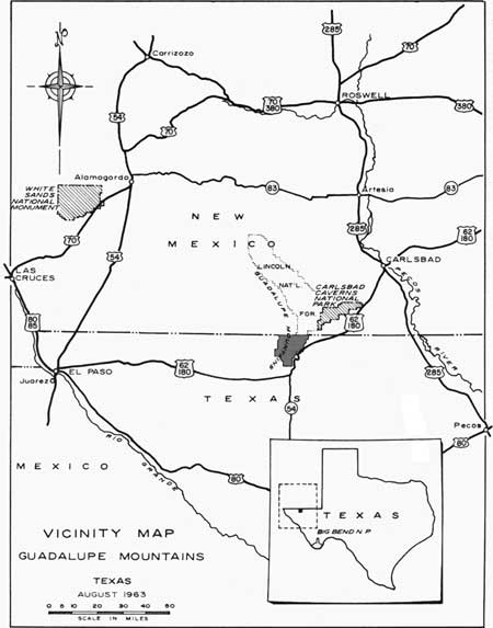
The Texas section of the Guadalupe Mountains is about 110 miles from El Paso, Texas, and 55 miles from Carlsbad, New Mexico. It is skirted by U.S. Highway 62-180.

|
| Vicinity Map, Guadalupe Mountains. (click on image for an enlargement in a new window) |
This report describes the potential of the area and some of its possibilities for development. The Texas section of the Guadalupe Mountains is highly significant geologically and ecologically, and is also ideally suitable for outdoor recreational purposes.
In 1961 the acceptance of Mr. Wallace Pratt's generous donation of 5,632 acres in the North McKittrick Canyon area of the Guadalupes was completed. Development terrain there is limited by the restricted canyon bottom and the fragile nature of the environment. This area should be administered to combine use by park visitors on foot with preservation of the scientific values.

|
| Air view of the Guadalupe Mountains from the southwest. The mountains rise toward the viewer, and culminate in Guadalupe Peak and El Capitan at the point of the "V". |
Additional land is needed in order to display the geologic story to more advantage, as well as to provide room for development and for visitor use. The land is now available, for Mr. J. C. Hunter, Jr., of Abilene, Texas, owns some 71,790 acres of land comprising most of the rest of the Guadalupe Mountains in Texas. The ranch is for sale, and Mr. Hunter would prefer that it be preserved for public use. The ranch should be acquired by the Federal Government and, combined with the North McKittrick Canyon lands, established as a National Park. Management should be such as to preserve the fragile nature of North and South McKittrick Canyons, while developing the higher reaches of the Guadalupes to the south for inspirational, interpretive, and recreational use.

|
| From Guadalupe Pass, El Capitan blocks out the summit of Guadalupe Peak. |
| <<< Previous | <<< Contents>>> | Next >>> |
gumo/report/summary.htm
Last Updated: 09-Feb-2007