 | ||
 | ||
 | ||
 | ||
 | ||
 | ||
 | ||
 | ||
 | ||
 | ||
 | ||
 | ||
 | ||
 | ||
 | ||
 | ||
 | ||
 |
 |
 |
Mount Rainier Roads and Bridges
Mount Rainier National Park, Washington
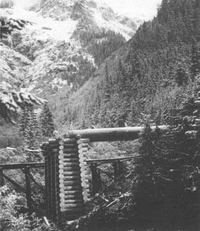
North Puyallup River Bridge under construction on the West Side Road, 1934. This section beyond Klapatche Point has been abandoned, and fragments of the bridge are still visible. |
WEST SIDE STORY
Construction of the southern section of the West Side Road began in 1926. By the time the road had been completed as far as the North Fork Puyallup River in 1934, park officials had decided against extending the road north through the rugged terrain to Carbon River; the cost would be too great, and construction would adversely impact the fragile park landscape. The road opened in 1934, and provided access to the Sunset Park and Indian Henry's Hunting Ground trailheads; a debris flow has closed the road since 1989.
A rough, unpaved road to the remote Mowich Lake region in the northwest corner of the park was completed in 1933 but was not opened to private automobiles until 1955. The road has seen little improvement, but continues to provide access to one of the most isolated areas of the park.
PLAN OF ST. ANDREWS CREEK BRIDGE
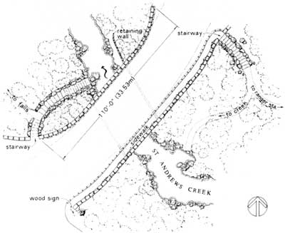
This skewed bridge was built on a curve with stone steps providing access to the creek. Such landscape details integrate the structure with its site. —Drawn by Julie Dickson, HAER,
1992.
|
| Introduction | Acadia | Blue Ridge Parkway | Chickamauga and Chattanooga | Colonial Parkway | Generals Highway | George Washington Memorial Parkway | Great Smoky Mountains | Mount Rainier | Rock Creek and Potomac Parkway | Shenandoah's Skyline Drive | Southwest Circle Tour | Vicksburg | Yellowstone | Yosemite |
