 | ||
 | ||
 | ||
 | ||
 | ||
 | ||
 | ||
 | ||
 | ||
 | ||
 | ||
 | ||
 | ||
 | ||
 | ||
 | ||
 | ||
 |
 |
 |
Shenandoah National Park
SKYLINE DRIVE
Virginia
ROAD CONSTRUCTION
|
"But it is for the far-reaching views
from the Skyline Drive that the park is most widely known. Macadamized
and smooth, with an easy gradient and wide sweeping curves, the Drive
unfolds to view innumerable panoramas of lofty peaks, forested ravines
and the patchwork of patterns of Valley and farms."
—Harvey Benson, Resident
Landscape Architect, Shenandoah National Park
|
The road was built in three sections during the 1930s. Work first began on the central section, from Thornton Gap to Swift Run Gap, in July 1931. This stretch opened to long lines of motorists on Sept 15, 1934. The north section (Thornton Gap to Front Royal) opened two years later on Oct 1, 1936. The south section (Swift Run Gap to Jarman Gap), opened on Sept 29, 1939. A fourth segment (Jarman Gap to Rockfish Gap) was originally constructed as part of the Blue Ridge Parkway and transferred to Shenandoah National Park in 1961.
Roadway excavation and grading began after the Skyline planners surveyed the route, prepared plans, and acquired the right-of-way. Constructed by a method of side-hill cut and fill, the roadway lay on a shelf carved out of, or built onto the mountain-side. This technique was mastered in western mountain parks like Yellowstone National Park, and became a standard procedure for building roads. Rock and soil excavated in cuts were used to build up fill areas. Controlled blasting techniques minimized unsightly landscape scars and conserved stone for other uses in construction.
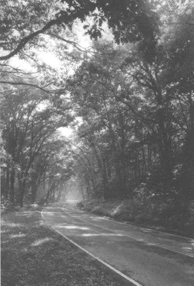
Tree branches form a natural arbor over the road between mile 58.6 and 58.8, creating a "Green Tunnel" in summer. As the park's forest vegetation matures, views from Skyline Drive change too; some distant vistas have geen replaced by intimate woodland scenes. —Bill Faust, HAER, 1996 |
The roadway was constructed with a base of six to eight inches of crushed stone, supporting an asphalt surface, coated with a waterproof seal. Parking overlooks and entrance roads to the park's developed areas were treated in similar ways.
|
"These mountains were just made for a
highway."
—NPS Director Horace Albright
recalled President Herbert Hoover telling him in the fall of
1930
|
Native stone was used in all the masonry work along the drive, such as retaining walls, hand laid rock embankments, drop inlets, culvert head walls, gutters, tree wells, drinking fountains, and guard walls. The rock came from roadway excavations or carefully selected quarry sites within the park or just outside its boundaries.
Skyline Drive originally featured 18 inch high, stone guard walls along steep stretches of the roadway. In 1983, the Federal Lands Highway Program initiated a major rehabilitation of Skyline Drive, replacing original guard walls and failed culverts. The new, and substantially higher, guard walls are constructed of a concrete core faced with cut stone from the historic walls, laid in a random pattern with prominent mortar joints. Estimated rehabilitation costs exceeded $326,000 a mile. The cost of original stone guard walls averaged one dollar per linear foot.
| Introduction | Acadia | Blue Ridge Parkway | Chickamauga and Chattanooga | Colonial Parkway | Generals Highway | George Washington Memorial Parkway | Great Smoky Mountains | Mount Rainier | Rock Creek and Potomac Parkway | Shenandoah's Skyline Drive | Southwest Circle Tour | Vicksburg | Yellowstone | Yosemite |
