 | ||
 | ||
 | ||
 | ||
 | ||
 | ||
 | ||
 | ||
 | ||
 | ||
 | ||
 | ||
 | ||
 | ||
 | ||
 | ||
 | ||
 |
 |
 |
Shenandoah National Park
SKYLINE DRIVE
Virginia
SKYLINE DRIVE TODAY
While technically not a parkway, the 105.5 mile, paved, two lane Skyline Drive displays elements standard to that road type (limited access, non commercial recreational traffic, access to adjoining recreational facilities, and exclusion of commercial development along the right-of-way). The roadway's graceful curvilinear design preserves the natural topography while presenting the landscape's scenic values.
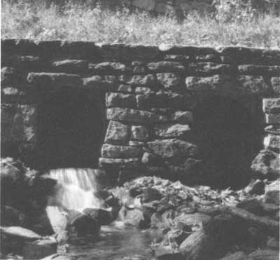
Strict NPS design standards extended to details motorists seldom see, like the random-rubble masonry headwall for this double culvert near Meadow Spring Trail Parking Area, mile 33.6. —Bill Faust, HAER, 1996 |
One of the nation's most heavily traveled recreational roads since it opened in 1934, Skyline Drive continues to serve the 2 million visitors who come to Shenandoah National Park each year. But the road is significant for more than it's function as the park's principle transportation corridor, or the outstanding scenery it offers. As a designed landscape, the drive was integral in the evolution of national park road and parkway design. Finally, the drive offered work and hope to thousands of Americans in the midst of the Great Depression, as part of the federal government's drought relief and New Deal programs. Despite changes in mountain vegetation, air pollution, automobiles, and slight roadway and park modifications, visitors today experience Skyline Drive much as motorists did in 1939, when they drove from Front Royal to Jarman Gap, and on through to Rockfish Gap for the first time.
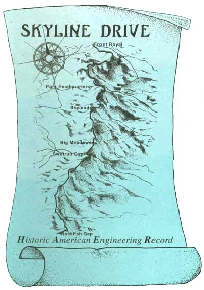
Bird's-eye map of Skyline Drive. —halren d. groe, HAER, 1996 |
| Introduction | Acadia | Blue Ridge Parkway | Chickamauga and Chattanooga | Colonial Parkway | Generals Highway | George Washington Memorial Parkway | Great Smoky Mountains | Mount Rainier | Rock Creek and Potomac Parkway | Shenandoah's Skyline Drive | Southwest Circle Tour | Vicksburg | Yellowstone | Yosemite |
