|
JOHN DAY FOSSIL BEDS
Geology and Paleoenvironments of the Clarno Unit John Day Fossil Beds National Monument, Oregon |

|
CHAPTER I:
INTRODUCTION AND REGIONAL GEOLOGY
INTRODUCTION
The scenic high desert of north-central Oregon contains a colorful volcanic and alluvial sequence of Tertiary age. The combination of low precipitation (320 mm annually in Antelope) and seasonal temperature extremes (January mean of -1 °C and August mean of 19 °C; Ruffner, 1978) favors xerophytic, sparse vegetation and good exposures. In contrast, fossil floras of Eocene age from sites in the Clarno Unit indicate paratropical climate analogous to that of modern southeast Asia (Manchester, 1981, 1994). The transition from steamy jungles of the past to the open ranges of today is recorded in a copious fossil record of a diverse flora, invertebrates, freshwater fish, reptiles, and mammals in this region (Merriam, 1901a, b, Merriam and Sinclair, 1907; Hanna, 1920, 1922; Merriam and others, 1925; Chaney, 1924; Stirton, 1944; Scott, 1954; Downs, 1956; Cavender, 1968; Mellett, 1969; Naylor, 1979; Manchester, 1981; Wolfe, 1981a and 1981b; Ashwill, 1983; Martin, 1983; Rensberger, 1983; McFadden, 1986; Manchester and Meyer, 1987; Hanson, 1989; Fremd, 1988, 1993). These profound paleoenvironmental changes are also reflected in sequences of paleosols ranging in age from middle Eocene to the present (Fisher, 1964; Retallack, 1981, 1991a, 1991b; Pratt, 1988; G.S. Smith, 1988; Bestland and others, 1994a, b). Three units of the John Day Fossil Beds National Monument (Sheep Rock, Clarno, and Painted Hills) were established for the protection and appreciation of these geologic and paleontologic resources.
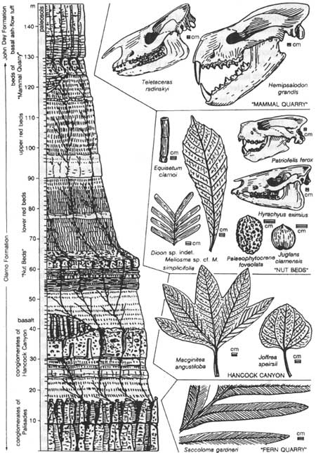
The purpose of this project is to provide an updated geologic and paleoenvironmental evaluation of the Clarno and John Day Formations in the Clarno Unit area of the John Day Fossil Beds National Monument. Special emphasis was put on stratigraphic and chronostratigraphic ordering of fossil sites in the area (Fig. 1.1). Detailed stratigraphic work focused on the upper part of the Clarno Formation in the interval containing the "Nut Beds" and "Mammal Quarry" fossil sites. New age determinations combined with local litho-stratigraphic mapping aimed to correlate fossils sites in the Clarno Formation with the North American and world wide paleontologic and paleoclimatologic data base. The study of the paleosols in the area was also a major focus. Most of the paleoenvironmental conclusions presented in this report were generated from our detailed study of the numerous and varied paleosols in the Clarno area.
The geologic framework of the area was addressed by mapping and stratigraphic documentation of lithostratigraphic units (debris flow deposits, lava flows, alluvial claystones, and pyroclastic deposits). This basic mapping was done in order to put the local stratigraphy into a regional context of the Clarno and John Day formations. Significant geologic work has been done in recent years by B. Hanson (Hanson, 1973; pers. communication, 1985, 1994), University of Oregon Geology Field Camp staff (A. Kays, D. Blackwell, E. Bestland, J. Stimac), Portland State Geology Field Methods staff (P. Hammond). However, little of this work has been published and much of this work is not currently accessible. Paleosols in the Clarno and John Day formations have been studied in some detail (Retallack, 1981; Pratt, 1988; Smith, 1988; Getahun and Retallack, 1991) and this project aimed to connect and extend this work. Until this project, the paleosols and geology of the Clarno Unit area were not comprehensively evaluated.
PREVIOUS WORK AND REGIONAL GEOLOGY
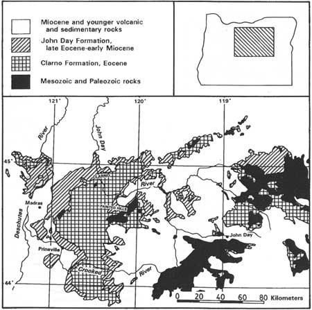
The Clarno Formation is a thick section (up to 6,000 ft, 1800 m) of largely andesitic volcanic and volcaniclastic rocks of Eocene age which crops out over a large area of north-central Oregon (Fig. 1.2). The formation was named by Merriam (1901) for exposures of volcanic rocks at Clarno's ferry, now a bridge over the John Day River just west of the National Monument boundary. A variety of older rock units underlie the formation and range from a melange of Permian-Triassic metamorphic rocks to Paleocene(?) arkosic sedimentary deposits. The Clarno Formation is overlain for the most part by the John Day Formation. Where the formation formed ancient volcanic highlands, younger rock units such as the Miocene Columbia River Basalt Group, Miocene Mascall Formation, Miocene-Pliocene Rattlesnake Formation and the Miocene-Pliocene Deschutes Formation, disconformable overlie the Clarno Formation.
Basement rocks
Basement rocks in north central Oregon consist of highly deformed metasediments of Permian to Triassic age (Hotz and others, 1977). In some areas, these are overlain by a thick sequence of Cretaceous marine rocks as in the Mitchell area of central Oregon. In the Clarno area, argillites of uncertain affinity are exposed in the Muddy Ranch dome. These folded argillites have been mapped as Cretaceous sedimentary rocks of uncertain age by Swanson (1969), interpreted as Paleocene sedimentary equivalents of the Herren Formation by Fisk and Fritts (1987), and interpreted as equivalents of the late Cretaceous Gable Creek and Hudspeth formations on the basis of lithologic similarities and non-Clarno Formation metamorphic character of these argillites (A. Kays pers. communication, 1993). Similar argillites occur in the Hay Creek Anticline and have been determined to be early to middle Eocene in age on the basis of coccoliths (Wareham, 1986). These basement rocks are intruded and overlain by andesitic volcanic and alluvial rocks of the Clarno Formation.
Clarno Formation
The Clarno Formation consists of non-marine volcanic and volcaniclastic units that range in age from middle to late Eocene, some 54 to 39 m.y. old (Evernden and others, 1964; Evernden and James, 1964; McKee, 1970; Enlows and Parker, 1972; Rogers and Novitsky-Evan, 1977; Manchester, 1981; Fiebelkorn, and others, 1982; Vance, 1988; Walker and Robinson, 1990; Bestland and others, 1993; Manchester, 1990, 1994). Volcanic plugs, lava flows, and lahars with convergent-margin andesitic compositions and textures indicate accumulation in and around andesitic volcanic cones (Taylor, 1960; Noblett, 1981; Suayah and Rogers, 1991; White and Robinson, 1992; Bestland and others, 1994b). The calc-alkaline volcanic rocks represent subduction related andesitic volcanism, probably on thin continental crust (Noblett, 1981; Rogers and Novitsky Evans, 1977; Rogers and Ragland, 1980; Suayah and Rogers, 1991). White and Robinson (1992) evaluated the sedimentology of the volcaniclastic deposits on a regional scale and interpreted the strata as non-marine volcanogenic deposits that were deposited in alluvial apron and braidplains that flanked active volcanoes. Some conglomerates and sandstones in the Clarno Formation record fluvial reworking of syn-eruptive deposits.
A variety of paleosols are present in the Clarno Formation; clayey alluvial paleosols of stable floodplains, weakly developed paleosols between debris flow deposits and andesite lava flows, and strongly developed residual paleosols with thick saprolite zones between major lithostratigraphic units. Thick, residual paleosols have been previously recognized in several areas of the Clarno Formation and referred to variously as "soil zones," "saprolite" or "weathering zones" (Waters and others, 1951; Peck, 1964; Hay, 1963; Fisher, 1964; Fisher, 1968). Some relatively continuous paleosol horizons have been used locally as marker horizons (Waters and others, 1951; Oles and Enlows, 1971), however, no regional stratigraphic framework utilizing volcanic marker beds or paleosol horizons has been attempted for the Clarno Formation (Oles and Enlows, 1971; Walker and Robinson, 1990). Red, clayey paleosols and thick saprolites are present throughout the Clarno Formation, but, thick and laterally continuous exposures of these weathering profiles are most common in the upper part of the formation. Their abundance toward the top of the Clarno Formation supports the extension of the Telluride erosion surface and its corresponding tectonic hiatus to the Pacific Northwest (Gresens, 1981).
John Day Formation
The John Day Formation consists of rhyolitic ashflow tuff and dacitic to rhyodacitic tuffs and alluvial deposits of latest Eocene, Oligocene, and early Miocene (22-to 39-my) age (Peck, 1964; Woodburne and Robinson, 1977; Robinson and others, 1990; Bestland and others, 1993, 1994a, b). These primary pyroclastic, alluvial and lacustrine deposits were supplied with volcanic ash from vents to the west in the Western Cascades (Robinson and others, 1984) and from vents now buried or partially buried by the High Cascade volcanic cover. Thus, the Clarno and John Day formations of central Oregon record a late Eocene westward jump of the subduction zone in the Pacific Northwest and a corresponding change from Clarno andesitic volcanism to Cascade volcanism and John Day back-arc basin deposition.
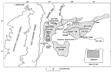
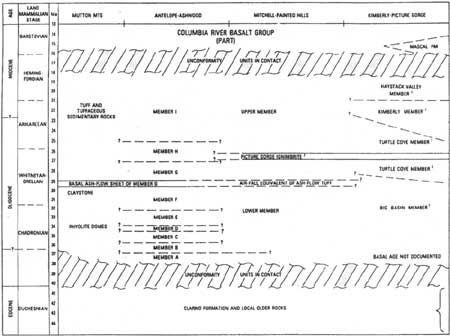
The John Day Formation is divided into an eastern, western, and southern facies (Fig. 1.3) on the basis of geography and lithology (Woodburne and Robinson, 1977; Robinson and others, 1984). The Blue Mountains uplift separates the western and eastern facies and restricted deposition of much of the coarser-grained pyroclastic material to the western facies. The western facies is informally divided into members A through I based largely on the presence at the base of members of ash-flow tuffs (Peck, 1964; Swanson and Robinson, 1968; Swanson, 1969). The western facies contains coarse-grained volcaniclastic deposits, welded ash-flow tuff sheets, and a variety of lava flow units including trachyandesite flows of member B, rhyolite flows of member C, and alkaline basalts in member F (Fig. 1.4). The Clarno Unit area is in the western facies where the John Day Formation has been mapped reconnaissance style by Robinson (1975) using the A through I stratigraphic divisions. The eastern facies is divided into four formal members (Fisher and Rensberger, 1972). From bottom to top they are, Big Basin Member (red claystones), Turtle Cove Member (green and buff tuffaceous claystones), Kimberly Member (massive tuff beds) and Haystack Valley Member (tuffaceous conglomerates). We report stratigraphic subdivisions of the John Day Formation in the Clarno Unit area based on both the A through I system of Peck (1964) and the formal members of the eastern facies of Fisher and Rensberger (1972) as modified by Bestland and others (1993) and Retallack and others (1994). The southern facies occurs south of the Ochoco Mountains and has a similar tuffaceous and zeolitized character as the Turtle Cove Member of the eastern facies but lacks the "Picture Gorge ignimbrite." New age determinations of tuffs from Logan Butte in the southern facies indicates that these deposits are coeval with the Turtle Cove Member (C. Swisher, pers. communication, 1993).

|
| Figure 1.3. Estimated distribution of the three facies of the John Day Formation in central Oregon (from Robinson and others, 1984). (click on image for an enlargement in a new window) |
Paleosols have been described from the John Day Formation by Fisher (1964, 1968) in the Turtle Cove-Big Basin area of central Oregon and by Retallack (1991b, c) throughout the John Day Basin and by Getahun and Retallack (1991) from the Clarno Unit area. According to Fisher (1964), laterization and the formation of an iron, kaolinite-rich hardpan occurred during the hiatus between Clarno and John Day volcanism. The iron-rich hardpan described by Fisher (1964) was developed on Cretaceous conglomerates and defines an erosional surface that has relief of up to 90 m. Fisher (1968) also compares less well-developed red and drab colored paleosols from the John Day Formation and noted their landscape association (well-drained with red colors and poorly-drained with drab colors) and their incipient lateritic character. Hay (1963) similarly recognized in these tuffaceous claystones evidence for "pre-burial weathering at the land surface," however his work focused on burial alteration, especially zeolitization, of the tuffs. Both Hay (1962a) and Fisher (1968) recognized distinct sedimentary facies in the John Day Formation, and inferred from these that hilly initial relief on the underlying Clarno Formation was mantled and subdued as deposition continued. Getahun and Retallack (1991) identified an Ultisol-like paleosol in the red basal claystones of the formation. Retallack (1991b,c) interpreted the change in paleosol types in whole of the John Day Formation from red clayey paleosols in the basal part to vitric calcareous paleosols in the upper part as indications of pronounced drying and cooling climatic conditions during Oligocene time.
| <<< Previous | <<< Contents>>> | Next >>> |
joda/bestland-retallack1/chap1.htm
Last Updated: 21-Aug-2007


