|
Katmai
Building in an Ashen Land: Historic Resource Study |

|
CHAPTER 6:
MINERAL EXPLORATION AND MINING
Early Prospecting Activity
RUSSIAN MINING ENGINEER Petr Doroshin made the first exploration of the Katmai country with an eye toward its mineral possibilities. In 1852, he headed westward from Kamishak Bay to Iliamna Lake and on to Bristol Bay. On his return trip, he ascended Naknek River to Naknek Lake and continued on to the "Mishket River" (probably the Ukak River), then returned to the Pacific Coast via Katmai Pass. Hearing of enticing possibilities for coal extraction, he dispatched a party to investigate "Kanikagluk Bay," which was probably either Amalik Bay or Kukak Bay. He was enthusiastic over the results, regarding the deposit as the best in Alaska. (The Russians, by this time, had established Coal Village at the southwestern tip of the nearby Kenai Peninsula, but they had not yet begun to develop the local coal deposit.) Doroshin and other Russians sought coal-development locations in order to supply the new California market. But before he could develop the deposits along the Katmai coast, he explored other coastal areas for their coal potential. By the time he returned to Russia, he had become convinced that the deposits near Coal Village had the most development potential. By 1865, the Russians had found evidence of petroleum near Katmai Bay, but due to a lack of interest it remained undeveloped. [1]
Few prospectors entered the Katmai country in the years following the American purchase of Alaska. The first known prospectors to visit the area crossed over Katmai Pass in 1890, and later that decade a ragtag army of prospectors headed over the same route on their way to the Nome gold fields. But so far as is known, none found "pay dirt" along the way.
The U.S. Geological Survey began surveying the coastline in 1895. William Healy Dall and George Becker were dispatched to search for gold and coal potential; they found no gold, but found two pockets of coal. Near Cape Douglas they found minor coal deposits. Along the shore of Amalik Bay—probably in the same place identified by Doroshin's investigators more than forty years earlier—they found "three seams of a pretty good coal," although "the small dimensions of the seam forbid anticipating any commercial future for it." Ralph Stone, who visited the same stretch of coastline for the agency nine years later, provided much the same conclusions for the Cape Douglas coal seams; he found that "because of their small extent and bony character" they had no commercial value.
In 1902, interest in the area's petroleum potential was raised again when an oil well was drilled near "Cold Bay" (now known as Puale Bay), just south of the present park. The discovery brought a bevy of activity to the area, but the initial well was not successful and by 1906 the area had been practically abandoned. The U.S. Geological Survey, hoping to lend a hand, sent geologist George Martin to survey the area for its petroleum potential. His report regarding the Katmai coastline was glum to an extreme. "The geology of the coast ... between Douglas River and Katmai [village]," he wrote, "does not warrant in the slightest degree any petroleum prospecting."

|
| Prospectors weighting out gold gust in payment for provisions that they purchased from the National Geographic Society's 1917 expedition. UAA, Consortium Library, Archives and Manuscripts Department, National Geographic Society Katmai Expeditions collection, Box 3, 3206. |
|
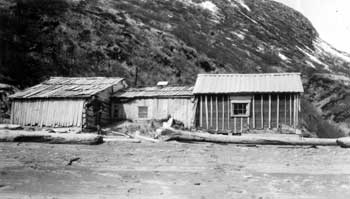
| Halferty's Cabin with Paul Hagelbarger, member of the National Geographic Society Katmai expedition, in Kuliak Bay, 1919. UAA, Consortium Library, Archives and Manuscripts Department, National Geographic Society Katmai Expeditions collection, Box 6, 5516. |
The 1912 eruption in the Mount Katmai area created a thick ash layer over hundreds of square miles of the surrounding landscape. Some mineral resources, therefore, were doubtless lost, but others were created; the USGS's George Martin returned to the Katmai coast during the summer of 1912 and was effusive about the commercial possibilities for the coastal ash deposits. [2]
The eruption affected prospecting activity only slightly; a prospector by the name of Bob Scott reportedly fled the area with the Savonoski residents. [3] Others, however, began trickling into the area soon afterward. Perhaps that same year, Charlie McNeil and Norman B. Cook found copper-bearing veins about 17 miles inland on a stream running into a "southwest bight" of Kamishak Bay. (The stream was probably McNeil River.) Z. T. and C. D. Halferty located seven claims in the Kuliak Bay area in 1913 and 1917. [4] In 1915, Fred and Jack Mason discovered placer gold along a small stream, locally called Lonesome Pine Creek, just south of Cape Kubugakli. Two years later, Robert Griggs discovered that "There are some places where one can gather crystals of sulphur, almost free from impurities, by the bushel." In 1918, Alex Grant found placer gold on American Creek; he made several attempts to work the gravels but failed. [5] The same year, the Geological Survey encountered the Shelikof Mining Company working at its copper prospect near Kukak Bay. Of those discoveries, only the Mason claim, which produced a small amount of gold, tin, and molybdenum over an eight-year period, ever witnessed ore production. [6]
The Monument Proclamation and Its
Impacts
In 1916, the National Geographic Society began to lobby various governmental officials to create a national monument in the ash-laden area surrounding Mount Katmai. In order to placate territorial authorities, the officials who roughed out the initial boundaries were careful to exclude known areas with commercial development potential; the southern boundary, in particular, was drawn so as to exclude the Cold Bay (Puale Bay), Cape Kubugakli, and Gas Creek mining properties. The relative lack of activity within the proposed boundaries encouraged park advocates to push for the creation of a monument that prohibited mining. [7] The USGS, which was asked for its opinion regarding the proposed withdrawal, indicated that it would not intercede against it, but neither could it muster much enthusiasm for it. Secretary of the Interior Franklin Lane, asked to make a final decision, conditionally agreed to the reservation despite the USGS's objections. Lane apparently felt that the land should be withdrawn pending a geological investigation; if that reconnaissance showed high mineral values, all or part of the monument could be returned to the public domain. [8]
In February 1920, Congress decided to open Alaska's public lands to oil prospecting again after a ten-year hiatus, and development interests responded by filing a flurry of oil leases in any areas in which USGS officials had shown petroleum potential. Thus in the Puale Bay area, oil leases blanketed the area to such an extent that some leases stretched all the way north to the monument's southwestern boundary. North of the monument, oil seeps had been discovered on the shoreline of Kamishak Bay; as a result, leases were scattered along the bay's southwestern shore and also went ten miles up the Kamishak River. The flurry of excitement, however, was all for naught. The only successful wells in the Cold Bay field were more than twenty miles southwest of the monument, and no drilling ever took place on the margins of Kamishak Bay. The oil leases were eventually cancelled. [9]
A small mineral development on the west shore of Shelikof Strait was responsible for the first alteration of Katmai's boundaries. In the early 1920s, John J. Folstad began working a coal seam on the western shore of Amalik Bay, opposite Takli Island. (This was probably the location that had been discovered by Becker and Dall in 1895.) In response, Folstad petitioned the government for a permit to develop the site. The NPS, recognizing the value of coal, knew that the petition might well result in pressure to open the entire monument to mining. The agency, therefore, felt it better to remove the area from the monument. On September 5, 1923, President Calvin Coolidge issued Executive Order No. 3897, which excluded 10 acres from the monument. [10]
In 1923, the long-expected Geological Survey expedition finally took place, when both Walter R. Smith and Kirtley F. Mather led survey parties into the Katmai country. Smith's party described and mapped much of the existing monument, and also fanned out to areas as far west as Dumpling Mountain and as far southwest as Becharof Lake. Mather's party surveyed the area to the north. It covered each of the coastal drainages from Paint River south to Cape Douglas, and also headed inland to survey the Savonoski River, Kulik Lake, Battle Lake, and Moraine-Funnel Creek drainages. The geologists found several mineralized areas in their surveys, most notably in the Paint River drainage and the Cold Bay area. The area within the monument, however, was "very little mineralized." Regarding the reputed petroleum deposits near Kamishak Bay, Mather could muster only a tepid enthusiasm. He felt that a search for petroleum was justified "throughout such of the southeastern portion of the Kamishak Bay region," but urged prospective drillers to first exploit the Cold Bay field first, where the geological structures appeared to be more favorable. [11] For the remainder of the decade, no other mining activities took place either inside the monument or in the immediately surrounding area.
In November 1930, Robert F. Griggs spearheaded an effort to extend Katmai National Monument's boundaries to the north and west. In a letter to an Interior Department official, Griggs gave a broad rationale for expanding the park and noted that there were "no minerals of value" except for a worked-out gold placer at Cape Kubugakli. As part of his expansion recommendations, he took care to avoid the oil-bearing tracts which surrounded Puale Bay. [12]
The following January the NPS, in consultation with Griggs and the Interior Department, laid out the boundaries of the proposed monument expansion. The Geological Survey, when asked its opinion of the area's economic geology, offered a dim view of the area's suitability as a park. The agency, advocating for known or suspected mineral locations, gave an optimistic analysis of the area's petroleum and gold potential. In addition, it noted that:
Regarding the area north of the present monument in the Kamishak Bay region, [geologist Kirtley F.] Mather reports a number of metallic mineral deposits in those places where igneous activity not related to recent volcanism has been intense. Conditions analogous to those described by him probably also occur in parts of the unsurveyed regions west and southwest of Cape Douglas, which is included within the boundaries of the enlarged monument. [13]
The Service, in response, offered to pare the size of its proposed expansion, and the final boundary line that was signed in President Hoover's April 1931 proclamation was a painful compromise between the NPS and the USGS. [14] A tacit effect of the expansion was its reincorporation of the 10-acre parcel that had been removed from the monument in 1923. (Folstad had long since lost interest in his coal claim.)
During the 1930s, as noted in Chapter 8, a small but stubborn group of trappers resided in various parts of the monument. Some prospectors doubtless also entered the monument, and a few of the trappers also prospected from time to time. As a result, three mining sites were located on the margins of the monument. Roy Fure and Martin Mickelson, both of Naknek, found a cinnabar vein in 1934 while traveling up Gorge Creek. Mickelson retorted about 200 pounds of the Gorge Creek vein but found that the mercury it contained was not of sufficient value to develop further. Fure, who continued to prospect in the area, found several more deposits just north of the original find. [15] In 1938, along American Creek, Bill Hammersly found additional placer gold deposits in the same general area where Alex Grant had prospected twenty years earlier. Hammersly continued to work the stream gravels each summer until 1941, by which time he had located eighteen placer claims that stretched one to two miles upstream from the monument boundary. He found extensive bench gold deposits; its quantity, however, was insufficient to sustain extended operations. The only other reported gold deposits were located along the shores of Lake Brooks. These deposits, located inside the boundaries of the monument—and thus extracted illegally—were apparently discovered in the late 1930s or early 1940s. Only small amounts were ever found. [16]
The situation was much the same along Shelikof Strait. As noted in other chapters, those who were attracted to the area were either trappers, fishermen or fox farmers. Once there, however, they sought whatever means they could to scratch out a living. On the north shore of Takli Island, W. E. Baumann located several placer claims beginning in 1931. There is no evidence, however, that either he or others in the area found anything of economic significance. [17]
In 1941, J. C. Roehm, an investigator from the Territorial Bureau of Mines, visited the Naknek Lake region and investigated the mining possibilities for various area properties. Roehm visited the American Creek claims and attempted but failed to visit those along Gorge Creek. [18]
Pumice Extraction
The Katmai area, in all likelihood, would have had little mineral extraction activity had demand been limited to hard rock minerals. What Katmai had in abundance was siliceous volcanic ash, otherwise known as pumicite. The 1912 eruption had extruded over five cubic miles of the material, enough to cover a 3,000-square-mile area a foot deep. [19] The ash, at that time, had no commercial value, and almost no one felt slighted when the 1918 proclamation placed most of the ash deposits within the monument's boundaries.
The value of pumicite, however, began to increase during World War II. Both the army and navy needed base materials in the construction of roads and airfields, and military personnel found pumicite superior to sand and gravel. After the war, Alaska faced an unprecedented demand for materials in the building construction industry, and various private sector interests recognized that pumicite might fulfill those needs. One Anchorage-based company began to extract ash deposits from Augustine Island, but it was soon discovered that the ash was an inferior material for the products they were producing. Casting about for an alternative, they visited Takli Island (within Katmai National Monument), took samples, and found them to be well suited to their needs. [20]
Pumice developers knew that Takli Island was located in Katmai National Monument and was thus off-limits to mining, but they hoped that the region's need for building materials might allow a legislative solution. So, beginning in April 1947, they began what proved to be a long-running campaign to allow pumice development. The campaign eventually involved the NPS Director, the Secretary of the Interior, and even the Attorney General's office. By the time it ended in April 1954, the pumice developers had been granted the legal right to extract pumice from the shore of Geographic Harbor, but by that time, the market had changed and pumice was no longer a sought-after material. [21]
Despite the Herculean efforts made by both developers and legislators to tap into Katmai's pumicite deposits, few on-the-ground impacts ever resulted. Takli Island was the site of a small operation during 1947, and Geographic Harbor witnessed some activity in 1950 and 1951. The latter operation, which took place along the west shore of the upper harbor, was never very sophisticated; major on-site equipment consisted of a barge, a Caterpillar, a duck (a large, amphibious truck) and a shack on skids. The shack remained for years afterward, but by 1985 all that remained was a large pumice berm, two four-foot pilings, and a few scraps of metal. [22]
Recent Mineral Development
In addition to the push to develop the monument's volcanic ash deposits, some hard rock extraction efforts were taking place as well. On November 14, 1948, pilot Bill Smith flew Charlie "Red" Robinson, trapper Jim Marlette, and a planeload of supplies to the eastern end of Lake Grosvenor. The location of the ore body, which supposedly held "rock mineral of high value content," is not known; it may have been the cinnabar deposits along Gorge Creek. Their entry into the area, however, was not discovered until the following April. Carlos Carson, the Dillingham-based fish and wildlife agent and deputy NPS park ranger, suspected that their entry was illegal and deduced that their mining activities were as well. Armed with a stack of regulations, Carson may have asked the miners to cease their operations, or perhaps the miners gave up on their own. [23]
Scattered amounts of other mining activity surfaced during the postwar years. In 1947, George Hadden occupied a cabin on the north shore of Takli Island; he was probably prospecting the same claims that W. E. Baumann had located back in 1931. (Takli Island had been absorbed into the monument in 1942. Mining claims made before that date, however, could still be developed.) [24] Marlette continued to prospect as well as trap, and had another camp along the Kulik River, north of the existing monument. His cabin was later eliminated by Northern Consolidated Airlines personnel, who had established a fishing camp on the river's north side, just west of Kulik Lake, in 1950. [25]
In 1954, the U.S. Geological Survey assigned A. Samuel Keller and Hillard N. Reiser to make a new investigation of the monument's geology and mineralogical potential. Their study also included a broad surrounding area, including Becharof Lake, Kulik and Nonvianuk lakes, the Kamishak River drainage, and the upper King Salmon River drainage. Keller and Reiser, who were primarily interested in the area's oil and gas deposits, gained the data for their study primarily by examining aerial photography and perusing existing reports, not by extensive field investigation. [26] To those who wanted to mine or drill, their conclusions were not encouraging. They were able to locate three broad bodies of coal-bearing rocks—west of Cape Nukshak, south of Geographic Harbor, and north of Dakavak Lake—but downplayed the monument's coal mining potential. In a similar vein, they described the location of several known or purported oil and gas seeps, but concluded that "it is unlikely that favorable petroleum strata can be reached at practical drilling depths on most of the structures that could be drilled." [27]
Another 1954 report dealt more specifically with the monument's hard rock mineral potential. G. Donald Eberlein, a mineral deposits geologist with the USGS, noted that the most promising mineral find was the gold deposit near Cape Kubugakli. Beyond that, however, Eberlein was pessimistic. He concluded that "we cannot rule out the possibility of ultimately finding additional deposits in the Monument ... although the likelihood that such deposits occur is not very great." [28]
When NPS officials, in the early 1970s, began to consider the expansion of Katmai National Monument and its conversion into a national park, they had to incorporate into their plans the proposed area's mineral values. Prior to August 1971, four copper and gold claims had been located along the south shore of Kulik Lake and six others were clustered in the upper Strike Creek drainage. A site containing an unknown mineral was also located in the upper Douglas River drainage, but no claim had been made there. In one of the NPS's three proposed "areas of environmental concern," there was also a series of unpatented lode claims, known collectively as the Pfaff claim, which were located on 1800 acres of land northeast of Battle Lake. None of the four mineral areas within the proposed park were patented. [29] In addition to the mineral claims, the proposed park addition contained 224 current oil and gas leases and one current oil and gas lease application, all located north of the existing monument. Based on the information in Keller and Reiser's study, however, the NPS felt that it was "unlikely that practical drilling operations in many areas will be able to reach structural and stratigraphic traps that have the potential for containing oil." [30]
When asked for their comments, in April 1974, the U.S. Geological Survey and the U.S. Bureau of Mines did not like the idea of an expanded Katmai National Park. The two agencies again noted the "high grade" deposits near Kulik Lake and Battle Lake, the high geothermal properties of the area, and continued to stress the high (though unproven) mineral potential of various geological structures in the area. But NPS officials were unmoved by such arguments, and the Final Environmental Statement continued to nominate for park status each of the known mineral potential areas that had been proposed in the draft document. [31]
In addition to those who responded with written comments, Ernest Pfaff spoke directly to NPS officials of the need to keep a portion of the proposed northern addition open to mining. Pfaff, a Naknek prospector who also held claims northeast of Battle Lake, told NPS staff that he had been prospecting in the area, particularly in the Kulik Lake drainage, since 1950. He had found five or six mineral deposits in the drainage during that time, but had recorded none of them. In the fall of 1972, he located what appeared to be a paying prospect north of the upper end of Kulik Lake, but because of the land freeze, he was unable to stake a claim. [32]
Soon after the Katmai enlargement, NPS personnel tried to ascertain the number of mining claims in the newly-expanded area. Their search revealed a total of eight claims—four lode and four placer—in three claim groups. They included four placer claims in the Sugarloaf Association group, the Dog #5 lode claim, and three lode claims which comprised the Pfaff claim group. None of the unpatented claims had records of previous mineral production. The Bureau of Land Management investigated these claims and found that the claimants to the Sugarloaf Association and Dog #5 claims had no legal rights to their properties, and by the end of May 1983 the agency had declared both claims null and void.
The Pfaff claim, therefore, was Katmai's only active mining claim group. Ernest Pfaff had discovered the lode, located four miles east of Battle Lake camp, in 1964. The mineralized vein, which straddles the border of the park and preserve, consisted primarily of gold- and chalcopyrite-bearing quartz, and also contained malachite, pyrite, and an unidentified silver-sulphosalt mineral. An undetermined about of ore was shipped during the next several years. [33] By July 1984, Pfaff had apparently abandoned his interest in the property, so he transferred his interest in the claim to Hawley Resource Properties, owned by Charles Hawley. The new claimant, however, made no further moves to develop its claim. In 1988, the claimant let its interest in the claim lapse, and on May 5, 1989, the Bureau of Land Management declared the claim null and void. [34]
Historic Property Summary and
Recommendations
Cape Kubugakli Gold Placers: In 1915, Fred and Jack Mason discovered placer gold along a small stream, locally called Lonesome Pine Creek, just south of Cape Kubugakli. The Mason claim, which produced a total of 160 ounces of gold along with tin and molybdenum over an eight-year period, was the only early hard-rock mine in the present-day park that has ever produced commercial quantities of ore. [35]
As part of its operation, the brothers probably established a sod house along the Kashvik Bay shoreline. In 1917, members of the National Geographic Society expedition visited and photographed that house. That same summer, those involved in the mining operation met the NGS expedition and were photographed at the NGS's Katmai Bay base camp, where they purchased provisions with gold dust. [36]
|
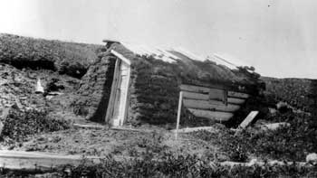
| The National Geographic Society's Katmai expedition came across this prospectors' sod house at Kashvik Bay in 1917. UAA, Consortium Library, Archives and Manuscripts Department, National Geographic Society Katmai Expeditions collection, Box 2, 831. |
So far as is known, NPS staff has not visited the location of the Mason brothers' placer mining operation, nor have they located the "prospectors' sod house" that NGS expedition members visited and photographed in 1917.
Takli Island Gold Claims: On the north shore of Takli Island, W. E. Baumann located several placer claims in 1931. (Joe Tanzer took out a fur farm lease in September of that year, and Baumann and Tanzer may have been working together.) Sixteen years later, George Hadden occupied a cabin on the north shore of Takli Island; this was the same cabin that trapper John A. Smith had used during the late 1930s and early 1940s. (Takli Island had been absorbed into the monument in 1942. Mining claims made before that date, however, could still be developed.) Hadden probably staked the same claims that Baumann had located previously. Neither Baumann nor Hadden produced commercial amounts of gold, and there is no evidence that either prospector worked the deposit that they had claimed. [37] The location or condition of these claims is not known.
Takli Island Pumicite Extraction Site: Anchorage developers spent much of the decade following World War II attempting to extract pumicite from Katmai's beaches. A focus of early concern was the extensive pumicite deposit on Takli Island. In 1947, Anchorage residents Don Goodman and Harold Swank formed the Pumice Block Company, and soon afterward they sent a small crew which "was active in developing deposits" on the island. That crew, which worked illegally, was probably on site for only a short time. During much of the long-running debate over securing legal access to these deposits, Takli Island was designated by legislators as an area that would be open to extraction if legal access was secured. But when a bill allowing access finally passed the U.S. Congress (H.R. 1529 in the 83rd Congress), the only site allowed for legal pumicite extraction was Geographic Harbor, ten miles to the northwest. [38]
The exact location of the 1947 pumicite operation is not known, and it is similarly not known if any evidence remains of either the extraction process or any equipment and supporting facilities associated with that operation.
Folstad Coal Prospect: The existence of coal on the western side of Amalik Bay was first identified in 1852 by a party under the direction of Russian mining engineer Petr Doroshin. For a short time, Doroshin thought that the site was the best coal deposit in Russian America. Later, however, he found a more promising coal development site on the Kenai Peninsula. More than forty years later, William H. Dall and George Becker returned to the spot. They found "three seams of a pretty good coal," but they were quick to note that "the small dimensions of the seam forbid anticipating any commercial future for it." Development did not follow either of these early reports. But in the early 1920s—several years after the area had been withdrawn as a national monument—John J. Folstad rediscovered the coal seam. Folstad was so optimistic about the site's development possibilities that he petitioned the government for a permit to develop the site. The NPS, recognizing the value of coal, knew that the petition might well result in pressure to open the entire monument to mining. The agency, therefore, felt it better to remove the area from the monument. On September 5, 1923, President Calvin Coolidge issued Executive Order No. 3897, which excluded 10 acres from the monument. [39] Folstad was therefore given free license to develop the coal site. But before long, he began to recognize what others before him already knew, that the site did not have long term development potential. He abandoned his claim, and in April 1931 the ten-acre parcel was reabsorbed into Katmai National Monument. [40]
|
| This 1919 photograph is labeled "Copper mine in upper Amalik Bay." UAA, Consortium Library, Archives and Manuscripts Department, National Geographic Society Katmai Expeditions collection, Box 6, 5513. |
Amalik Bay Copper Prospect: When National Geographic Society investigators, in the summer of 1919, made a reconnaissance of various bays and coves along Shelikof Strait, they visited and photographed a so-called "copper mine in upper [northern] Amalik Bay." Details about the prospect are unknown. This may be the same prospect as that referred to in the U.S. Geological Survey's annual report for 1918; it noted that the Shelikof Mining Company's work "was continued" that year at its copper prospect "near Kukak Bay." Nothing more was heard from the company after that year. No structures are known to be associated with this prospect. [41]
Geographic Harbor Pumicite Extraction Site: As noted in the discussion of the Takli Island Pumicite Extraction Site (above), developers and bureaucrats engaged in an eight-year battle over whether and how pumicite mining would take place along Shelikof Strait within the monument. At first the development interests showed little interest in Geographic Harbor because the site's pumicite was inferior in quality. Despite that admonition, however, surreptitious development took place there during the early 1950s. In the summer of 1950 John Grove, who headed the Stock and Grove Company of Anchorage, brought a crew of six into Geographic Harbor and extracted pumicite; the following year, the company repeated the process in the same location." The company appears to have operated legally by working below the high tide line (this zone was technically out of the NPS's jurisdiction), but they kept their equipment and a shed above high tide, which was illegal without a special use permit. Although territorial officials were immediately aware of the operation, the NPS did not learn of it until the following winter. In the summer of 1951, agency planner George Collins visited the site; shortly afterward, the NPS issued Grove a cease and desist order and shut it down. [42]
In the meantime, developers and bureaucrats continued to battle over legalized access to the monument's beaches. A solution was not reached until the 83rd Congress passed a bill, which was signed by President Eisenhower on April 15, 1954, allowing pumicite extraction only on "those lands within one-quarter (1/4) mile of mean high tide in Geographic Harbor at latitude 58° 08' N., longitude 154° 36' W." Shortly after the enactment of the above legislation, one company attempted to remove pumice from the described area, but they were unsuccessful in developing a market. And to their further discouragement, they lost one of their barges in a storm on Shelikof Strait. This was the only attempt to develop the pumice. [43]
Regarding site improvements, the USGS 1:250,000 map for the area, published in 1951, shows a cabin along the west side of upper Geographic Harbor in T24S, R33W, S12. In 1984, a fisherman told an NPS ranger that he remembered a small shack at this location "a long time ago." But by the mid-1980s, all that remained at the extraction site was a large pumice berm, two four-foot pilings, and a few scraps of metal. [44]

|
| View of Kuliak Bay with Halferty's Cabin off to the right, 1917. UAA, Consortium Library, Archives and Manuscripts Department, National Geographic Society Katmai Expeditions collection, Box 5, 5301. |
Kuliak Bay Prospecting Complex: In 1913, and again in 1917, Z. T. and C. D. Halferty made located several mining claims on the slopes overlooking Kuliak Bay. (Kuliak Bay is the first deep, double-pronged indentation south of Kaflia Bay.) Most if not all of those claims were 1-1/2 to two miles west or northwest of the bay. [45] They called this bay (which may have described just the southern indentation of Kuliak Bay) "Montaigne Bay;" later observers, however, called it "Hafferty Bay" in misspelled deference to these prospectors.
Little is known about activity there prior to 1919, when a National Geographic Society expedition visited the bay. That year, however, the Halfertys "sent seven feet of shaft 6' [deep] x 4'" [in diameter] during a twelve day period. This labor was probably related to a copper, gold, and silver prospect that had been located in 1917. [46] That same year, NGS expedition members photographed two buildings related to the prospecting operations: a long (three-room) milled-wood building situated just above the high tide line, and a smaller milled-wood cabin up the hill slope. The former building was probably a headquarters for various prospecting operations in the bay, while the latter structure may have been adjacent to one or more of the prospects. Judging from the buildings they constructed, the Halfertys were either wealthier or more optimistic than most prospectors; they were certainly willing to invest more than a minimal sum in their quest for hard rock minerals. [47]
Nothing is known about any operations after 1919. Years later, part of the fate of the prospects came to light in a letter from an Alaska Game Commission agent. In a letter to the Mount McKinley National Park superintendent, agent Jack Benson noted that "at one time there was a quartz prospect in Hafferty [sic] Bay, the second indentation north of Kinak Bay. Remains of the old camp were found during my last trip to the coast. It is understood that a man by the name of Hafferty was pleased with his prospects, but has since died and no one has taken over." [48] So far as is known, no NPS personnel have visited or commented on either the prospects or the buildings in Kuliak Bay.
Gorge Creek Cinnabar Prospect: In 1934, prospectors Roy Fure and Martin Mickelson found a cinnabar vein while traveling up Gorge Creek, a tributary of Hardscrabble Creek (east of Lake Grosvenor) near the monument's northern border. Fure, at the time, spent his winters at his Bay of Islands trapping cabin and his summers in Naknek, while Mickelson lived in Naknek. After their discovery, Mickelson retorted about 200 pounds of the Gorge Creek vein but found that the mercury it contained was not of sufficient value to develop further. Fure, who continued to prospect in the area, found several more deposits just north of the original find.
The site was forgotten for more than a decade. The years following World War II, however, brought an increased interest in the area, and two men made a renewed effort to tap the resource. On November 14, 1948, pilot Bill Smith flew trapper Jim Marlette and Charlie "Red" Robinson, along with a planeload of supplies, to the eastern end of Lake Grosvenor. None of the three publicized which ore body they hoped to develop, but this "rock mineral of high value content" was probably the cinnabar deposits along Gorge Creek. Their entry into the area, however, alarmed Carlos Carson, the Dillingham-based fish and wildlife agent and deputy NPS park ranger, because he suspected that the ore body was within the monument boundary; if so, any mining activities would be illegal. What took place next is unknown; Carson may have asked the miners to cease their operations, or perhaps the miners gave up on their own. It is not even known if Marlette and Robinson extracted any ore at the site. Either way, the cinnabar site was abandoned and no known development activities have taken place since then. [49]
So far as is known, no NPS personnel have visited the cinnabar extraction site. Discovery of its location along Gorge Creek is of more than trivial interest, because the southwest side (right bank) of the creek was inside of Katmai National Monument's boundaries in both 1934 and the late 1940s while the northeast side (left bank) was part of the public domain.
Battle Lake Claims: Ernest Pfaff, a longtime Naknek resident, had been prospecting in the mountains east of Naknek, and particularly in the Kulik Lake drainage, ever since 1950. (Pfaff Peak, located southwest of Battle Lake, became a recognized geographic name when a U.S. Geological Survey map of the area was published in 1951.) In 1964, Pfaff located what appeared to be promising prospects in the mountains northeast of Battle Lake. The site, located four miles east of Battle Lake camp, consisted primarily of gold- and chalcopyrite-bearing quartz, and also contained malachite, pyrite, and an unidentified silver-sulphosalt mineral. Pfaff located a series of lode claims, totaling 1,800 acres. Pfaff shipped an undetermined about of ore during the next several years but never moved to patent his claims.
When NPS officials, in the early 1970s, began to consider the expansion of Katmai National Monument and its conversion into a national park, they first proposed placing Pfaff's claims into one of three "areas of environmental concern." Later, however, they dropped that designation, and upon the recommendation of Interior Secretary Cecil Andrus, President Carter opted to include the area within an expanded Katmai National Monument, which he designated on December 1, 1978. Two years later, Pfaff's claims were included within the boundaries of Katmai National Park and Preserve; they straddled the border between park and preserve land.
Interior Department personnel, asked to verify the authenticity of the various mineral claims in the areas that had become conservation units because of the Alaska Lands Act, determined by May 1983 that the three Pfaff claims were Katmai's only valid mining claims. Just a year later, in July 1984, Pfaff transferred his interest in the claim to Hawley Resource Properties, owned by Charles Hawley. The new claimant made no further moves to develop the property. In 1988, Hawley let his interest in the claim lapse, and on May 5, 1989, the Bureau of Land Management declared the claim null and void. [50]
NPS cultural resource personnel, as part of the Mining Inventory and Monitoring Program, visited the mine site in August 1989. They observed just two bulldozer scrapes at the three claims; in addition, a thirty-foot wanigan and a 1500-foot airstrip were located 1.5 miles northeast of the claims. All three of these resources probably date from the 1960s.
American Creek Gold Prospects: In 1918, prospector Alex Grant7#151;who apparently had a cabin along the Brooks River and may have trapped in that area—found placer gold on American Creek. He made several attempts to work the gravels but finally gave up after facing many "adverse conditions." Twenty years later, Rufus "Bill" Hammersly found additional placer gold deposits in the same general area. Hammersly continued to work the stream gravels each summer until 1941, by which time he had located 18 placer claims. Both Grant's and Hammersly's mining was legal; when Grant was active, Katmai National Monument had not yet been designated, and when Hammersly was prospecting, the monument's boundaries were one to two miles downstream from his placer claims. Hammersly found extensive bench gold deposits; the quantity of those deposits, however, was insufficient to sustain extended operations. [51] So far as is known, NPS personnel have not re-located or evaluated these claims.
As the various site descriptions indicate, only two of the eight identified mining sites in Katmai National Park and Preserve have been visited and described by NPS personnel. Therefore, it is recommended that cultural resource personnel make a systematic effort to locate and describe these sites. The existence of just eight known mineral production sites within the 4.1 million-acre expanse of Katmai National Park and Preserve certainly suggests that the area's potential mineralization is small in comparison with other mountainous areas in Alaska; moreover, the mining sites that have been developed do not appear to follow easily identifiable chronological or spatial trends. Therefore, it does not appear that a thematic study of the park's mining sites, with an eye toward a multiple property National Register of Historic Places nomination, is warranted at this time. Individual properties, however, may well be considered for the National Register if evidence obtained from site visits reveals adequate supporting data.
Endnotes
1 Hussey, Embattled Katmai, 112-13, 312.
2 Ibid., 375; L. W. McFarland (James H. Rhodes and Co.) to National Geographic Magazine, February 21, 1917, in Box 24, Griggs Collection, NGS.
3 Hussey, Embattled Katmai, 331.
4 Ibid., 417; Orth, Dictionary of Alaska Place Names, 612-13; Item 9, "Status of Research on Mineral Claims," in Breedlove, Preliminary Draft, Basic Data, Advance Master Plan/Wilderness Research, KATM.
5 Hussey, Embattled Katmai, 410, 418; J. C. Roehm, "Summary Report of Mining Investigations in the Kvichak Precinct, Alaska, June 13 to July 6, 1941," Alaska Territorial Department of Mines Report 195-31, 1.
6 G. C. Martin, "The Alaska Mining Industry in 1918," in Mineral Resources of Alaska, Report on Progress of Investigations in 1918, USGS Bulletin 712, (Washington, GPO, 1920), 35; A. H. Brooks, "Alaska's Mineral Resources and Production, 1923," in Mineral Resources of Alaska, Report on Progress of Investigations in 1923, USGS Bulletin 773 (Washington, GPO, 1925), 39; Walter R. Smith, "The Cold Bay-Katmai District," in USGS Bulletin 773, pp. 206-07.
7 Antonson and Hanable, Administrative History of Sitka National Historical Park, 81; William E. Brown, A History of the Denali-Mount McKinley Region, Alaska, 93.
8 Hussey, Embattled Katmai, 411-12, 415, 456-57; Kauffmann, Katmai National Monument, Alaska, 6-7; Albright, The Birth of the National Park Service, 75.
9 USDI, Annual Report of the Governor of Alaska for 1921 (p. 30), 1922 (p. 37), and 1923 (p. 30); Kirtley F. Mather, "Petroleum on Alaska Peninsula; Mineral Resources of the Kamishak Bay Region," in Mineral Resources of Alaska, USGS Bulletin 773 (1925), 174.
10 Hussey, Embattled Katmai, 421; Kauffmann, Katmai National Monument, Alaska, 7-8.
11 Mather, "Petroleum on Alaska Peninsula,", 174, 180; Walter R. Smith, "Cold Bay-Katmai District," in Mineral Resources of Alaska, USGS Bulletin 773, (1925), 206.
12 Kauffmann, Katmai National Monument, Alaska, 10, 12.
15 J. C. Roehm, "Summary Report of Mining Investigations in the Kvichak Precinct, Alaska, June 13 to July 6, 1941," Alaska Territorial Department of Mines Report 195-31, 5-6.
17 Item 9, "Status of Research on Mineral Claims," in Breedlove, 1969, in Box 13, NARA Anchorage.
18 Roehm, "Summary Report of Mining Investigations," 3, 5, 9; Alfred C. Kuehl, "Report on Katmai National Monument, Alaska," 3.
19 Bernard F. Hubbard as told to Barrett Willoughby, "Volcanoes Packed in Ice," Saturday Evening Post 203 (August 23, 1930), 18; Hussey, Embattled Katmai, 345.
20 J. L. McCarrey to E. L. Bartlett, April 16, 1947, in Pumice Bill File, Bartlett Collection; Territory of Alaska, Department of Mines, Report of the Commissioner of Mines for the Biennium Ended December 31, 1948, 14. J. C. Roehm, in his "Preliminary Report on Some Pumicite Deposits," September 1947, p. 1, noted that samples had been taken from the southwestern end of Geographic Harbor, five miles northwest of Takli Island.
21 Norris, Isolated Paradise, 356-65.
22 Herbert Maier (Acting RD/R4) to Dir. NPS, August 7, 1951; George Collins, August 19, 1951 memo in pencil; both in File 609-01, Box 312, RG 79, NARA SB; Melanie Neuman and Kim Heacox, Katmai National Park and Preserve, Katmai Coast Field Season Report, 1985 (King Salmon, NPS, 1985), 50.
23 C. M. Carson to O. A. Tomlinson (RD/R4), April 19, 1949, in File 609-01, Box 312, RG 79, NARA SB; Grant Pearson to C. M. Carson, April 27, 1949, in File 208, Box 311, RG 79, NARA SB; O. A. Tomlinson to C. M. Carson, April 28, 1949, at KATM.
24 Roehm, J. C. (Associate Mining Engineer), [Preliminary Report on Some Pumicite Deposits, Katmai National Monument, Alaska] Report MJ-126-1 (Juneau, Alaska Bureau of Mines), September 1947, 6.
25 "Affidavit of Elmer S. Harrop," June 23, 1983, in BLM Melgenak File (AA-7604), AKSO-EL.
26 Director USGS to Director PNRO, May 15, 1973, in Box 13, NARA ANC.
27 A. Samuel Keller and Hillard N. Reiser, Geology of the Mount Katmai Area, Alaska, USGS Bulletin 1058-G (Wash., GPO, 1959), 278-82, 291; Director U.S. Bureau of Mines to Director PNRO, May 17, 1973, in Box 13, NARA Anchorage. Keller and Reiser's work was reprised in Don J. Miller, Thomas G. Payne, and George Gryc, Geology of Possible Petroleum Provinces in Alaska, USGS Bulletin 1094 (1959), 33.
28 Robert S. Luntey (Chief, Office of Resource Planning, San Francisco Planning and Service Center) to Park Planner Breedlove, Alaska Field Office, January 28, 1969; George D. Gates (Chief, Alaskan Geology Branch, USGS) to Bennett Gale (WASO), December 2, 1954; both in Item 9, "Alaska Borough and Mining Districts," Breedlove, 1969.
29 Alaska Planning Group, Proposed Katmai National Park, Alaska, Draft Environmental Statement, December 1973, 129-30; Alaska Planning Group, Final Environmental Statement, Proposed Katmai National Park, Alaska, 1974, 97; NPS, "Distribution and Density of Mineral Entries, Proposed Katmai National Park Additions," December 1, 1977, Box 15, NARA ANC. Both the 1974 and 1977 reports noted that a small, active small gold placer operation and gold-copper operation were located on Crevice Creek, 22 miles west of the mouth of McNeil River. The mine site, however, was later discovered to be outside of the proposed park.
30 Alaska Planning Group, Proposed Katmai National Park, Alaska, Draft Environmental Statement, December 1973, 135; BLM, "Historical Index" sheets for various townships in the area of the proposed addition, located at BLM State Office, Anchorage.
31 Alaska Planning Group, Final Environmental Statement, Proposed Katmai National Park, Alaska, 1974, 33, 252-55, 259-63, 315-16, 394; Director USGS to Director PNRO, May 15, 1973, in Box 13, NARA ANC.
32 Al Henson (Project Leader, ATFO) to Asst. Director, Cooperative Activities, WASO, March 13, 1973; NPS, "Katmai National Park, Statement on Special Problems," n.d. (1973); NPS, "Minerals," in "Katmai EIS Comments" folder, n.d. (1974?); all in Box 13, NARA ANC. Pfaff had first become known to NPS officials back in May 1949, when he wrote the agency and asked if the monument was open to uranium prospecting. He received a kind but firm negative reply. Jackson E. Price, (NPS Office of the Chief Counsel, WASO) to Ernest Pfaff, July 25, 1949, at KATM.
33 H. C. Berg and E. H. Cobb, Metalliferous Lode Deposits of Alaska, USGS Bulletin 1246 (Washington, GPO, 1967), 14, B78-79.
34 SAR for 1985 (p. 7) and 1986 (pp. 6-7); BLM, Serial Number AA-025641 through AA-025643, Alaska State Office, Anchorage.
35 Norris, Isolated Paradise, 351; Hussey, Embattled Katmai, 418.
36 National Geographic Society, Katmai Expedition Photo Albums, 1917, Box 2, Photos 831-33, UAA Archives.
37 Norris, Isolated Paradise, 356, 367.
39 Hussey, Embattled Katmai, 421; Kauffmann, Katmai National Monument, Alaska, 7-8.
40 Norris, Isolated Paradise, 353, 355.
41 National Geographic Society, Katmai Expedition Photo Albums, 1919, Box 6, Photos 5512-13, UAA Archives; Norris, Isolated Paradise, 351.
42 Norris, Isolated Paradise, 363.
43 Oscar T. Dick (Supt. MOMC) to Paul Arpin, San Jose, Calif., April 7, 1965, in DENA Collection.
44 Stroud and Fuller, 1984 Coast Field Season Report, 14-15.
45 Bailey Breedlove, Preliminary Draft, Basic Data, Advance Master Plan/Wilderness Research, Katmai National Monument, Shelikof Strait-King Salmon, Alaska (Anchorage, NPS) June 1969, #9, "Status of Research on Mineral Claims."
47 National Geographic Society, Katmai Expedition Photo Albums, Box 5, 5301, and Box 6, 5512 and 5516 (all taken in 1919), UAA Archives.
48 Jack Benson to Frank Been, March 17, 1941, DENA Archives.
49 Norris, Isolated Paradise, 355, 366.
katm/hrs/chap6.htm
Last Updated: 22-Oct-2002