|
Katahdin Woods and Waters National Monument Maine |
|
 NPS photo | |
NATURAL HISTORY
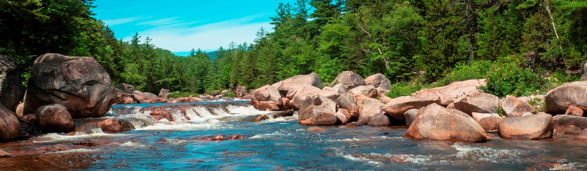
More than 87,500 acres along the East Branch of the Penobscot River, the Seboeis River, and Wassataquoik Stream lie within the boundary of Katahdin Woods and Waters National Monument. Here you will find a diverse mix of tree species including alder, ash, aspen, beech, birch, cedar, fir, hemlock, maple, oak, pine, and spruce. River valleys and prominent ridges of sand and gravel formed by glaciers over the last 2.5 million years hint at the unique geology underlying the woods and waters.
SPRING AND SUMMER As temperatures rise in spring and summer, the area blooms with life, green leaves fill the forest, and water rushes through the rivers and streams. Wildflowers such as lady's slipper, bloodroot, trout lilies, and Dutchman's breeches are found in the dappled sunlight of the forest floor. Insects like mayflies and black flies are abuzz, migratory woodland birds stop to rest or nest in the canopy, and raptors soar overhead.
Aquatic mammals, like otters and beavers, can be spotted in wetlands or rivers. Otters are fish-loving mammals with warm, thick coats and webbed feet that help them swim, even in near-freezing waters.
There is an abundance of life below the surface of the streams and rivers, native, self-sustaining populations of brook trout inhabit most of these waters, and smallmouth bass can be found in the East Branch of the Penobscot below Grand Pitch. The East Branch and its two largest tributaries, the Seboeis River and Wassataquoik Stream, provide excellent spawning and nursery habitat for Atlantic salmon, and play an essential role in restoring a self-sustaining population of this species to Maine's Penobscot River drainage.
AUTUMN AND WINTER Mammals like chipmunks and black bear prepare for winter by reducing activity and heat production. Others are equipped with thick fur to keep them warm and padded or hooved feet to make their way through the snow. Birds such as the ruffed grouse grow small feathers on their feet to provide insulation for walking in the snow. In winter, martin, otter, moose, white-tailed deer, and the federally threatened Canada Lynx — or signs of these species — can be seen here.
The peaceful forests within Katahdin Woods and Waters National Monument help tell the story of the Maine woods, a landscape spanning nearly 11 million acres across the State of Maine.
CULTURAL HISTORY
For at least 10,000 years, the Wabanaki people hunted, gathered and fished in these forests, streams and rivers. Using the Penobscot River watershed as a transportation network, the Wabanaki traveled between inland and coastal locations, such as Frenchman and Penobscot Bays. Archaeological and historic records of this extensive Native American presence can be found within the Katahdin Woods and Waters National Monument. The Penobscot Nation, one of the five tribes of the Wabanaki Confederacy, considers the Penobscot River to be the heart of their rich culture and core spiritual values.
Infrastructure to support the timber harvesting industry, including a network of roads, opened up a new way for hunters, anglers, and hikers to explore the area. Henry David Thoreau, who made "The Maine Woods" famous through his publications, traversed the East Branch of the Penobscot River with his Penobscot guide, Joe Polis. In 1879, Theodore Roosevelt crossed the East Branch and followed the Wassataquoik Stream to summit Mount Katahdin. The route up Katahdin by way of the Wassataquoik was taken by many, including Percival P. Baxter, who devoted his life to conserving what became Baxter State Park.
For hundreds of years, natural beauty and scenic vistas have drawn artists and scientists. John James Audubon paddled the Penobscot in 1832 collecting specimens to paint for his book of illustrations, "Birds of America." Frederic Edwin Church of the Hudson River School painted views of Mount Katahdin. Geologists discovered well-preserved fossils in bedrock spanning more than 150 million years of the Paleozoic era. The glaciated landscape provides endless opportunities for geological and ecological study.
ALLURE AND ADVENTURE Today, Katahdin Woods and Waters National Monument offers year-round recreation opportunities and invites you to enjoy the sights, sounds, and smells of the Maine woods. Whether you are on the trails or waterways, you will see why this special place inspired its original inhabitants, artists, conversationalists, and outdoor enthusiasts for generations.
A TRADITION OF TIMBERING
Timber harvesting began in the northern Maine woods more than three centuries ago and by 1830, the forests in the Katahdin region were a major source of wood to the world's largest lumber shipping port in Bangor. Throughout the 1900s, the Great Northern Paper mill in Millinocket became the destination for much of the pulpwood harvested. During the winter, the woods were teeming with active timber harvesting camps and lumberjacks using axes and handsaws to harvest pine and oak for shipbuilding, cedar for shingles, hemlock for tanning, and spruce and fir for pulp to make paper. Wood was transported to market using horses, the Penobscot River, and later, by rail. Traditional timber harvesting continued well into the 20th century when new techniques reduced the impact on the resources, while still providing the raw materials used in a multitude of products.
Working forests in the Katahdin Region around the monument today utilize mechanized equipment to harvest and transport timber, making the process speedier, less wasteful, and safer. This vast renewable resource supports thousands of jobs and is vital to the economic health of the region.
For Your Safety
General: Be advised that this is a new National Monument. Amenities are limited and signage is sparse. Cell phone reception can be spotty or non-existent.
Driving: Vehicles with regular to high clearance are recommended. All roads leading to and within the Monument are gravel and rough with ruts, potholes, and sharp rock edges. These roads serve a dual purpose as active private timber harvesting and haul roads. Visibility can be limited due to dry and dusty conditions. Many of the bridges are single lane so be prepared to stop and move over.
Yield to log trucks. Log trucks have the right of way and cannot stop suddenly.
Use at your own risk, some roads may not be passable.
Drive carefully and slowly with your lights on, and be alert for oncoming log trucks.
Never stop on a corner, bridge, or where you will block a road.
Approach with caution any timber harvesting activity and remain at a safe distance until the crew indicates it is safe to approach more closely.
Pets on leash are allowed in the Monument. Keeping your pet on leash and under control helps protect your pet, visitors, and wildlife.
Directions
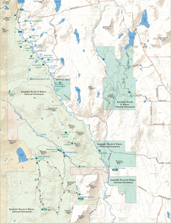 (click for larger map) |
Katahdin Woods and Waters National Monument is located in north central Maine, approximately a 2.5-hour drive west of Acadia National Park and 1-hour drive north of Bangor, Maine.
Generally, wheeled vehicles may access the North/Matagamon entrance from mid-May to mid-November; and the Loop Road from Memorial Day to mid-November.
All parts of the Monument are accessible from I-95 Exits 244 (Medway) and Exit 264 (Sherman.)
LOOP ROAD access is via Route 11 and the Swift Brook Road - 20 miles north of Medway (EXIT 244) or 5 miles south of Sherman (EXIT 264) on Route 11. Access to the Swift Brook Road is on a sharp corner. Use caution with this turn as sight distance is limited. The Swift Brook Road, which is a gravel road, will lead you to the Katahdin Loop Road in 10 miles.
NORTH/MATAGAMON entrance access is via Route 11 and Highway 159 and the Grand Lake Road - 34 miles north of Medway (EXIT 244) or 9 miles north of Sherman (EXIT 264). All roads are paved until the turn off of the Grand Lake Road and then the road is gravel. Route 11 and the Monument are also accessible on I-95 South from Exit 276 (Island Falls).
In winter, road access to the Monument is via the North/Matagamon entrance only. This entrance offers a small parking area for access to groomed multi use non-motorized trails.
Contact Information
|
Patten Lumbermen's Museum Open seasonally. Memorial Day through June: open weekends July through Columbus Day: open Tuesday - Sunday, and holidays; 10am - 4pm Brochures, trip planning information, and passport stamps available. |
Millinocket Contact Station Open year-round. Memorial Day weekend through Columbus Day: seven days a week; 8am - 4pm October through May: 1 day per week; 1 pm - 4 pm Brochures, trip planning information, and passport stamps available. |
Katahdin Woods and Waters National Monument |
Source: NPS Brochure (undated)
|
Establishment Katahdin Woods and Waters National Monument — August 24, 2016 |
For More Information Please Visit The  OFFICIAL NPS WEBSITE |
Documents
Boy Scouts on Katahdin (Walter Prichard Eaton, 1924)
Conserving a Vision: Acadia, Katahdin, and the Pathway from Private Lands to Park Lands (Sean Flaherty and Anthony Moffa, extract from Maine Law Review, Vol. 71 No. 1, 2018)
Cross Country Ski Trails, Katahdin Woods & Waters National Monument (c2017)
Foundation Document Overview, Katahdin Woods and Waters National Monument, Maine (August 2016)
Katahdin Woods & Waters National Monument Area/Recreation Maps (c2017)
Paleontological Resource Inventory (Public Version), Katahdin Woods and Waters National Monument NPS Natural Resource Report NPS/KAWW/NRR-2022/2472 (Justin S. Tweet, Vincent L. Santucci and Isabel Ashton, October 2022)
Presidential Proclamation 9476 — Establishment of the Katahdin Woods and Waters National Monument (Barack Obama, August 24, 2016)
Vegetation Map for the Seboeis Unit of Katahdin Woods and Waters National Monument U.S. Geological Survey Scientific Investigations Report 2022-5078 (Andrew C. Strassman, Kevin D. Hop, Stephanie R. Satter, Justin Schlawin and Don Cameron, 2022)
kaww/index.htm
Last Updated: 01-Jan-2025