|
Lava Beds
Modoc War Its Military History & Topography |

|
INTRODUCTION
From the very beginning, encounters between American whites and the Modoc Indians were classical in nature. The high, cool, lake—dotted borderland between California and Oregon witnessed somnolent days of peacefulness broken sharply by moments of fierce violence. Beneath the shining perfection of Mount Shasta, death came to both Indian and white in the form of whining bullets. An observer might have predicted the outcome to be a wretched remnant of the redman struggling against total extermination.
It came to that in the end. But not before a handful of Modocs stunned America by winning bloody fights against incredible odds. The battle flags were theirs; yet, final victory, if such there was, belonged to the whites. That time is called the Modoc War.
Capt. John Charles Frémont (though it could have been anyone) established the precedent for violence. In May 1846, he was moving along the dim trail that joined California to the Columbia River, when he was overtaken by a courier whose message urged him to return south to partake in the defeat of Mexican rule. Frémont reversed his footprints near Upper Klamath Lake and headed back. That night the Modocs' neighbors, the Klamath Indians, slipped through the shadows and attacked the young explorer's camp with arrows and axes, killing three men. Though Frémont was in a hurry he still found time and opportunity for revenge by raiding a village as he headed toward his troubled destiny. [1]
Later that year a group of fifteen Oregon settlers, including Jesse and Lindsay Applegate, passed through the Klamath and Modoc country working its way eastward to carve a new route for the Oregon Trail. They hoped this South Road would allow future overland immigrants to reach the Willamette Valley of Oregon with less difficulty than they themselves had experienced on the Columbia River route. When they reached the north shore of Tule Lake on July 6, they found the lower end of Lost River too deep to ford. Lindsay Applegate described how they surprised an Indian and forced him to disclose a crossing place: "he led the way up the river about a mile and pointed out a place where an immense rock crossed the river." The group was delighted to find that "the sheet of water running over the rock was about fifteen inches deep, while the principal part of the river seemed to flow under." Known as Stone Bridge, this unusual ford served travelers through the Modoc country for the next several years. [2]
Other than the loss of some cattle by theft, the immigrants who traveled the South Road that first autumn had little trouble with the Modocs. However they experienced one of the worst winters in Oregon's early history, and many starved and suffered greatly. [3] Perhaps because of this difficulty, travel remained light on the South Road until the early 1850's. When prospectors located new gold deposits in northernmost California, a marked increase in travel and settlement followed. Although the mines lay west of their homelands, the Modocs came more and more into contact with free—wheeling whites. Influenced more by greed than self-protection, the Indians began attacking pack and wagon trains. In the fall of 1852, they slashed out at several small caravans at a place on the eastern shore of Tule Lake where the South Road went between an outcropping of lava and the water. Soon to be called Bloody Point, this narrow shore received the bones of at least 36 whites that year. [4]
Fifty miles west of Tule Lake, the leading mining center of Yreka reacted sharply to these attacks. A posse of citizens under Ben Wright rode toward the lava country to revenge the killings. Twice that fall, the Wright party attacked the Modocs, inflicting heavy casualties. For the moment Modoc strength was crushed; yet the bloodshed of that time left a heritage of bitterness on both sides. The prevailing attitude among whites that all Indians should be exterminated was greatly reinforced. The surviving Modocs, including two named John Schonchin and Curley-headed Doctor, would not forget Ben Wright. [5]
While they continued to make minor raids on small parties of whites from time to time, the Modocs offered no great threat in their greatly weakened state. Even during the Rogue River War, 1856-57, they played no significant role, other than defending themselves when necessary. Instead, they gradually cultivated relations with whites by assimilating their culture. Although many in the tribe remained in their homeland around Lower Klamath, Tule, and Clear Lakes, and Lost River, which joined the latter two, a number of men worked for the whites on their ranches and in Yreka. Modoc men soon learned that the white miners would pay a price for a Modoc woman, and the Indians became the peddlers of their own flesh. They adapted themselves to the white mode of clothing and accepted readily such customs as drunkenness. The Modoc after 1860 seemed but a caricature of his former self.
Long before the time of troubles, the Modocs had lived proudly in their hard, beautiful land. They and their more-numerous blood-relatives, the Klamaths, had occupied the area that came to be southcentral Oregon and the northern fringe of central California. Hunting, fishing, and root-gathering had provided sustenance; occasional forays against the Pit River Indians to the south and the Paiutes (Snakes) to the east had provided the means for the development of leaders and the skills of warfare. Contributors to and borrowers from the culture of the Great Basin, they had lived contentedly in their semi-permanent villages along the streams and lakes in the quiet valleys. [6]
Guarded on the west by the snow-covered and occasionally volcanic peaks of the Cascade Range, on the north by immense pine forests, on the east by gaunt ancient ridges and vast alkali plateaus, and on the south by incredibly twisted lava flows of recent origin, the lakes and streams gave haven to immense numbers of birds and fish. The marshes and meadows provided seeds, roots, and berries. Animals, small and large, dwelt in the valleys and among the sage and junipers of volcanic cones and isolated ridges. [7] It was a land of distant vistas, clear-cut horizons, storm-swept lakes, hazy autumns, fog-enshrouded cliffs, snow-covered lava flows, honking geese, whistling winds, and deep silences — silences that would in a few years be broken by the roar of howitzers and the crack of mortars.
E. N. T.
|
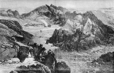
| William Simpson's dramatic sketch of the Stronghold, published in the Illustrated London News. Although simplified, this drawing gives some sense of the difficulty the troops experienced in capturing the area. |
| <<< Previous | <<< Contents>>> | Next >>> |
thompson/intro.htm
Last Updated: 11-Nov-2002