|
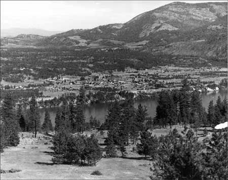
Lake Roosevelt
Currents and Undercurrents An Administrative History of Lake Roosevelt National Recreation Area |

|
CHAPTER 2:
The River Becomes a Lake
The U.S. Bureau of Reclamation (Reclamation) began constructing Grand Coulee Dam in the late 1930s after years of studies to determine the best ways to irrigate the Columbia Basin. The government purchased the land that would be flooded, and several thousand laborers cleared the reservoir area. During the summer of 1942, the reservoir behind the dam filled with water, and a 132-mile stretch of the mighty Columbia River became Lake Roosevelt.
Construction of Grand Coulee Dam
The decision to build the massive Grand Coulee Dam was not made casually. The controversy revolved around the location, design, and ultimate purpose of such a structure, not over its impacts upon humans and the natural environment. The dam was ultimately built as part of the Columbia Basin Irrigation Project, a huge federal project designed to irrigate much of the arid land in eastern Washington.
|
Roll on, Columbia, roll on, Roll on, Columbia, roll on, Your power is turning the darkness to dawn Roll on, Columbia, roll on. And far up the river is Grand Coulee Dam, The mightiest thing ever built by a man, To run the great factories and water the land, It's roll on, Columbia, roll on. -- "Roll On, Columbia," words by Woody Guthrie, 1941 |
Two methods of irrigating the Columbia Basin were proposed and examined. The idea to build a large dam on the Columbia River and pump water into a storage reservoir in the Grand Coulee for irrigation was first proposed in the 1890s. It was countered by a rival plan to bring water to the Columbia plateau by a 134-mile gravity-flow canal from the Pend Oreille River in northern Idaho. The controversy over the relative benefits of these two schemes, the "pumping plan" and the "gravity plan," polarized Washington and national reclamation politics through the 1920s. Rufus Woods and the Columbia River Development League promoted the idea of a dam at the head of the Grand Coulee that would generate hydroelectric power to pump water above the dam into the Grand Coulee.
In 1918, Woods published an influential story on the idea in his newspaper, the Wenatchee Daily World. Washington power companies and the city of Spokane favored diverting water to the Columbia Basin, and they created the Columbia Basin League to promote that concept. Each side acted in its own self-interest, and the bitter debate lasted from 1918 until 1933. [1]
The Reclamation Service (now the U.S. Bureau of Reclamation), the Army Corps of Engineers, and engineers sponsored by the state of Washington and by private organizations spent over thirty years surveying the area and preparing reports on the feasibility of the two methods of irrigating the Columbia Basin. A decisive study known as the Butler Report, completed in 1931, provided an honest assessment of the two plans, coming out on the side of the pumping plan largely for economic reasons. Once the "pumpers" had won the prolonged debate, however, they still were faced with the daunting task of finding state or federal funding for the costly project. [2]
|
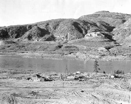
| Site of Grand Coulee Dam looking north across the Columbia River, January 23, 1934. Note the ferry crossing. Photo courtesy of National Park Service, Lake Roosevelt National Recreation Area (LARO 2622). |
The federal role in damming the Columbia tied in well with the New Deal belief that the government should stimulate economic recovery by putting people to work and encouraging the creation of public utilities. Franklin D. Roosevelt, elected president of the United States in 1932, asked for plans for a low dam with foundations strong enough to support a higher dam later, one that would back water up to the Canadian border. In July 1933, Public Works Administration funds were allotted for the state to build a low dam at the Grand Coulee, and a few months later it became a federal project to be built by Reclamation. The cost was to be repaid from net revenues obtained from the sale of hydroelectric power. Within a few years, four gigantic concrete dams were all being constructed at the same time: Hoover (Boulder), Shasta, Bonneville, and Grand Coulee. Hoover Dam, authorized in 1930, set the stage for integrated river basin planning. The New Deal backed the multiple-purpose concept for dams and also emphasized federal control and planning for the development of entire river basins. The Columbia River was soon well on its way to becoming an orderly and regulated waterway, managed to meet the needs of humans. [3]
Congress created the Bonneville Power Administration (BPA) in 1937. Although public power advocates had hoped for a Columbia Valley Authority modeled after the Tennessee Valley Authority, the BPA was not given such comprehensive authority. Its role was to market the power generated at federal dams, including Grand Coulee Dam. Because the BPA is charged with repaying the investment the federal government made in constructing the dam and the annual maintenance and operations costs, that agency also is involved in the operational aspects and the associated effects on cultural resources, recreation, endangered species, and other resources. Reclamation, however, operates and maintains Grand Coulee Dam and associated facilities. Title to all the land is held by the United States of America. [4]
|
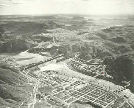
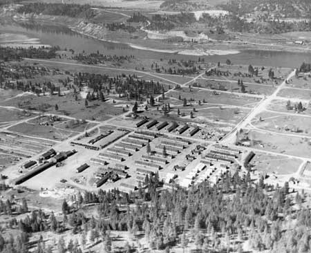
| Aerial view of the towns of Mason City (foreground), Engineers Town (across the river), and Grand Coulee (background), April 1940. The Grand Coulee extends to the right in the distance. Photo courtesy of U.S. Bureau of Reclamation, Grand Coulee (USBR Archives 536). |
The project of building Grand Coulee Dam is remarkable for its magnitude but not for any strikingly original technical accomplishments. The dam is a concrete, straight, gravity-type dam that rests on bedrock granite. Work began in 1933. Frank A. Banks was appointed Construction Engineer, and he stayed with the project until he retired in 1950. Soon some eight thousand workers, many of them young, single men, were employed on the dam construction project. Reclamation and the contractors constructed towns on both sides of the river close to the dam site to house their employees. By the end of 1937, the east and west sections of the dam had met. [5]
The decision to build Grand Coulee Dam higher than had originally been planned determined the size of the reservoir behind the dam. In 1933, the dam was designed to be a 200-300-foot low dam that would generate power and help in regulating navigation flows but would not aid in the proposed irrigation project. The reservoir created by the low dam would have reached 1,111 feet in elevation. In June 1935, Reclamation issued a change order for construction of the 500-foot high dam, which allowed for a reservoir reaching 1,290 feet in elevation and extending to the Canadian border. The Rivers and Harbors Act, signed August 1935, authorized the dam for the purposes of flood control, navigation, stream flow regulation, storage and delivery of stored waters, reclamation of public lands and Indian reservations, and the generation of hydroelectric power. Grand Coulee Dam had evolved into a major national project, not just a local New Deal relief measure. [6]
|
| Drawing, ca. 1933, showing the difference in reservoir size between the low and high dams proposed for the Grand Coulee project. Photo courtesy of Washington State University (Grand Coulee Dam Site file, box 2A, Bridges and Dams, PC2). |
Acquiring Land for the Reservoir Behind Grand Coulee Dam
|
Most of the 3,000 persons who were forced to
move accepted their fate philosophically. . . . Many felt that this
forced evacuation released them from a bondage that held them in the
great canyon where tradition and custom bound them inevitably to a life
of drudgery and poverty. -- WPA press release, 1940 [7] |
When construction of Grand Coulee Dam began in 1933, many American Indians lived along the river bottoms between Whitestone Creek (near Jones Bay) and Inchelium and also farther upstream. Most were concentrated on the tongues of land close to the water or on the low benches along the river. A number of ferries crossing the river served these people and their neighbors farther from the riverbanks. Only a handful of white families lived in the immediate vicinity of the dam site, but a number of communities and small farming settlements were located along the river farther upstream. Fruit orchards, livestock raising, farming, logging, and mining supported the people living along the river. When construction of the dam began, the residents of northeastern Washington, white and Indian alike, were suffering from the effects of a series of agricultural recessions and mine closures and the nationwide Depression. [8]
|
Sometimes I just can't help but wonder if things might have been better
up here if they hadn't built the dam. I think about it every spring when the water is down and I see that old town [Marcus] down there. It's not a pretty sight. -- Ed Frostad, former resident of old Marcus, 1985 [9] |
Beginning in 1933, Reclamation engineers prepared to purchase land and rights-of-way for a reservoir that would stretch some 151 miles from the dam to close to the Canadian boundary. Surveyors worked for several years setting permanent monuments along the approximate 1,310-foot "taking line" to indicate the land the government needed to acquire. The "Columbia River Reservoir" eventually flooded approximately 70,500 acres, and Reclamation took an additional 11,500 acres of "freeboard" land (the strip of land between the 1,290 water line and the 1,310-foot taking line) for the reservoir. Within this area lay two railroads, three primary state highways, about one hundred and fifty miles of country roads, fourteen bridges, eleven towns, four sawmills, four telegraph and telephone systems, and many power lines and cemeteries. All of these had to be purchased and/or relocated before the waters came. Some towns were relocated to higher ground, but a number of small communities were not. In total, some three thousand people had to leave their homes because of the creation of the reservoir. [10]
As early as 1933, an appraisal board began valuing the twelve hundred parcels of land to be purchased. The appraisers considered the physical value of the land and also its productive and residential values. When landowners did not accept final government purchase offers, Reclamation filed condemnation suits. Many property owners felt that they did not receive fair value for their land. By the close of 1942, all of the lands required for the reservoir had been acquired by purchase or condemnation or were under contract to purchase. In the end, over $10.5 million was paid for this land, including town lots and farms, plus the relocation of railroads, highways, sawmills, and other improvements. [11]
|
|
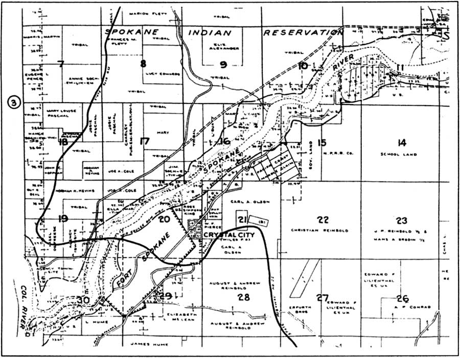
Portion of a 1930s map showing the land
ownership at the confluence of the Columbia and Spokane rivers. The
dashed line represents the water line at 1,300 feet, but the actual
water line was at 1,290 feet and the taking line for Bureau of
Reclamation acquisition of land was at a minimum of 1,310 feet.
(Metsker's Atlas of Stevens County, Washington, [1930s],
Stevens County Historical Society.) (click on image for an enlargement in a new window) |
The federal government paid property owners the market value of their land but did not cover moving and relocation costs. This was standard policy until 1958, when Congress authorized payment for moving expenses. Some homeowners sold their property (real property — land — and improvements) to the government, then bought the house back for salvage at much lower cost. They then lived in the building until required to evacuate because of rising water and paid the moving expenses if they wished to relocate the house. These costs could be high; for example, house movers charged about $125 to move a home from old Marcus up to the new townsite less than a mile away on the hill. Reclamation did pay, however, for the moving of some buildings, such as the U.S. Forest Service Kettle Falls Ranger Station and Great Northern Railway facilities. [12]
|
| Town of Kettle Falls, 1938. Photo courtesy of National Park Service, Lake Roosevelt National Recreation Area (LARO 2784). |
Projected distances below water:
|
The reservoir flooded eleven towns that had post offices. Daisy, one small town that was relocated, had three stores, two churches, a blacksmith shop, a creamery, a saloon, a highway department garage, and a high school. The school was rebuilt in a new location, but only the store and the service station were relocated. The town of Kettle Falls found a novel solution to its problem. Unable to obtain land adjacent to St. Paul's mission, their first choice for a new town site, Kettle Falls residents annexed the nearby higher town of Meyers Falls and a strip of land along the state highway connecting the two communities. The residents of both towns, after some political maneuvering, then voted to abandon the old town site and the strip. They gave the old town of Meyers Falls the new name of Kettle Falls. Many residents of Meyers Falls resented this forced merging of their town with their relocated neighbor. Marcus, with a population close to six hundred in 1940, was the largest town that had to be relocated. It was moved to a bench some 145 feet above the former town. [14]
Inchelium was another town that was flooded by the reservoir. The community had about 190 residents in the 1930s, mostly members of the Colville Confederated Tribes (CCT). There was heated controversy over the location of the new town, and in the end, the school and the Indian subagency were relocated a few miles away from the new town. Because payment for the school building was tied up in litigation, the school board had no money to buy or move the building, so the rising water began to flood the school. Ultimately, Reclamation had to lower the reservoir level to allow trucks to move the school at the last possible minute. Long-distance phone service was not provided to the new town for thirty years. Many of Inchelium's former residents had to move to other areas such as Okanogan, Omak, and Tonasket that were far from their homes. Many older people, according to anthropologist Verne Ray, died of grief, and the damage to the traditional culture was "incalculable." [16]
|
The river was the central and most powerful
element in the religious, social, economic, and ceremonial life of my
people. Suddenly, all of this was wiped out. The river was blocked,
the land was flooded. The river we had known was destroyed. Our
homesites were gone. The fordings were made impossible. The far banks
were beyond our reach. The root-digging prairies were cut off. The
salmon came no more, and with the disappearance of the salmon, our
traditional economy was lost forever. -- Jim DeSautel, member, Colville Confederated Tribes, 1977 [15] |
Besides established towns, hundreds of year-round villages and seasonal campsites of the CCT and Spokane Tribe of Indians (STI) had been established along both sides of the Columbia River and its larger tributaries, all waters that carried the life-sustaining salmon. In the 1930s, descendants of these people on the two reservations continued to live along the rivers. The southern half of the Colville Reservation was allotted to individual Indians in 1916 but held in trust by the government for the next twenty-five years. Members of both tribes chose their allotments adjacent to the Columbia River or the Spokane River whenever possible. Many of these people's homes were located within the future reservoir area. [17]
The right to purchase tribal and allotted lands was accomplished by the Acquisition of Indian Lands for Grand Coulee Dam Act of June 29, 1940, which authorized the Secretary of the Interior to take lands for reservoir purposes. There were three classes of land ownership on the two reservations: Indian allotments assigned to an individual for his personal use (the Indian owned the property but could not sell it - title was held in trust by the U.S. government); tribal lands (communal property of the entire tribe held in trust by the U.S. government); and alienated lands (Indian title extinguished, usually through homesteading or outright purchase). The actual acquisition of Indian allotted lands began long before the 1940 act was passed, and many people were forced to relocate before they even had been paid for their land and buildings. The acquisition of tribal lands was relatively simple, since the Secretary of the Interior was the trustee for these lands. Alienated lands were treated the same as privately owned lands not located on the reservations. [19]
|
Lands acquired within the reservations for Grand Coulee Dam and Lake Roosevelt:
| ||||||||||||||||||||||||||||
The Act of June 29, 1940 required the Secretary of the Interior to determine the amount of money to be paid to the Indians as compensation for their lands. This was done on the basis of appraisers' reports and a Reclamation-prepared description of the land proposed to be acquired. The appraisal done by Reclamation's Board of Appraisers turned out to be more favorable to the owners of allotted lands than an independent appraisal done by the Office of Indian Affairs, due to different methodologies. The Reclamation appraisal was adopted, and funds were transferred to pay the Indian allottees or their heirs. In total, 18,203 acres of allotted and tribal land was purchased on the Colville Reservation and 2,900 acres (including the Klaxta town site) on the Spokane Reservation. Most of Klaxta, the area where the Spokane and Columbia rivers join, has since been turned back to the STI. [20]
Reclamation reported that the appraisals of Indian land were made on exactly the same basis as the appraisals of lands outside the reservations, but many tribal members at the time and in subsequent decades have disputed this contention. Most Indians received $500-$700 for their land. One man's timberland was reportedly appraised at the same value as sagebrush land. Under the Act of 1940, however, the decisions of the Secretary as to the value of allotted lands were final. Landowners with title in hand could challenge the appraised value and negotiate the amount of compensation, but the Indians' land was taken by "declaration" because the federal government had retained title to the allotted and tribal lands. [21]
|
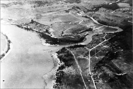
| Aerial view of the confluence of the Columbia and Spokane rivers, 1932. The bridge across the Spokane River was one of several that had to be relocated. The new bridge is closer to the confluence and historic Fort Spokane. Photo courtesy of National Park Service, Lake Roosevelt National Recreation Area (LARO 2961). |
The CCT and STI suffered far-reaching injuries beyond the loss of their homes and land. Hundreds of Indian burials were relocated; others were inundated by the rising water. The construction of Grand Coulee Dam and the flooding of the reservoir destroyed fundamental aspects of tribal culture and forced Indians into a new, undesired way of life. The arrival of thousands of non-Indian dam workers and the construction of towns to house them created cultural conflict.
Both tribes gathered roots and berries on lands south of the Columbia River; this ended because of the influx of non-Indians to these lands and because crossing the reservoir was so difficult. Hunting was affected by the flooding of much bottomland forage. School-age children living in the Keller area of the Colville Reservation had to take a forty-mile (one way) school bus and ferry ride to school in Wilbur. The reservoir flooded sites with mythological significance, places to gather pitch wood and driftwood, and rock art. All these related impacts created great personal hardship and economic dislocation. The benefits to the tribes, on the other hand, were few. Relatively few tribal members were employed in the construction of the dam. The irrigation aspect of the project benefited lands south of the reservations, not agricultural lands owned or farmed by Indians. [22]
Another tremendous loss for the American Indians of the region was the loss of the fishery at Kettle Falls, the mouth of the Sanpoil River, Little Falls, and other places along the upper Columbia River in the area flooded by Lake Roosevelt. At the time of white contact, several species of salmon taken from the Columbia and tributaries provided perhaps half the total diet of the Colville and Spokane tribes. The salmon was also important to the tribes' religion, economy (dried salmon was traded for other goods), and social life. The fish runs on the Columbia River and in the Kettle Falls area began declining in the late 1800s due to commercial fishing in the lower Columbia and the Pacific Ocean and the construction of downstream dams. The sudden and complete loss of the salmon fishery upstream of Grand Coulee Dam dramatically changed the way of life of Indians living along the upper Columbia. [23]
|
We had a beautiful way of life. We were rich.
The dam made us poor. The way they treated us, they tried to make us
less than human. . . . We Indians trust the day is past when the nation
will approve of what the government did when they built the dams, which
back in those days caused one of our people to say, "The promises made
by the government were written in sand and then covered with water, like
everything else." -- Lucy Covington, member, Colville Confederated Tribes, 1977 [24] |
In June 1940, American Indians from around the Pacific Northwest gathered at the site of St. Paul's mission above Kettle Falls for a final three-day "Ceremony of Tears" to mourn the loss of the ancestral fishing grounds. A crowd estimated at eight to ten thousand people attended the gathering. Chief Peter Joseph of the Kalispel commented that the government should reimburse the tribes for the loss of their fishing grounds, and Senator Clarence C. Dill pledged his support for a measure to accomplish this. [25]
One specific concern of both tribes in subsequent years has been the high cost of electricity to tribal members living on the reservation. The rates are much higher on the Colville Reservation than in the town of Coulee Dam, for example, even though the BPA had assured the tribes that electricity would be extremely cheap as a result of the dam. The BPA response is that they sell power at the same rate to electrical utilities; the difference in users' costs is due to the varying cost of distribution, so rural residents face higher bills than people living in towns. [26]
Clearing the Land for the Reservoir
Clearing the reservoir area was one of the largest Work Projects Administration (WPA) projects ever undertaken. The clearing project was completed in December 1941; it took just over three years from start to finish. The WPA furnished all the labor, built the camps, and operated the mess halls, and Reclamation supplied the equipment and materials. Most of the area cleared lay between the low-water elevation of the Columbia River and its tributaries and elevation 1,290 feet, but clearing was done higher in upper reaches of the reservoir and in areas with landslide potential. Approximately 54,000 acres were cleared, over 11,000 acres grubbed (even the roots were dug up), and thirty-three million board feet of merchantable timber harvested. When the work was completed, the government had spent $4.9 million on labor. [27]
The height of Grand Coulee Dam and the maximum level of the reservoir were determined by the elevation of the Columbia River at the Canadian border. The water level in the lake is not allowed to rise above 1,290 feet; otherwise, it would back water into Canada. In the early 1930s, Reclamation surveyors marked the 1,290-foot high-water line to show the land to be cleared of trees, brush, and other objects that could present hazards to boaters or to the water intakes behind the dam. The clearing procedure varied with elevation. Between 1,250 and 1,290 feet, most combustible or buoyant material was uprooted, pulled, or grubbed for complete removal, then piled and burned (small brush was cut off flush with the ground, and non-combustible material was razed and placed in pits). Between 1,200 and 1,250 feet, stumps were cut no more than six inches above the ground. Between the Columbia River and 1,200 feet, stumps were cut no more than two feet above the ground. Building foundations, walls, and chimneys were razed, and brush less than three feet high was left as it was. [28]
Timber cruising to estimate the amount of merchantable timber was done in the late 1930s. The timber within the reservoir area was logged by WPA crews, skidded to the river, and floated downstream where it was sold to the highest bidder. In 1939, the Lincoln Lumber Company bid $2.25 per thousand board feet for this timber. The company's mill was located at the mouth of the Spokane River, so timber cut downstream ended up being burned or otherwise disposed of. This lumber company's plant close to the river had to be dismantled when the backwaters advanced. The trees in the many peach orchards along the river were uprooted and burned. [29]
Reclamation began surveys for the relocation of railroads and roads in the reservoir area in 1935, and contractors began constructing the realignments that spring. Great Northern Railway branch lines to Nelson, British Columbia, and to Republic, Washington, had to be realigned. Old roads within the reservoir area were kept open as long as possible. Some ninety miles of state highways were reconstructed, under supervision of the state. Reclamation supervised the construction of relocated county roads and then turned them over to the counties. New highway bridges were built. Affected roads on the two reservations totaled approximately thirty-three miles, and the Indian Service did the relocation work on these roads. Old railroad bridges were dismantled and new ones constructed. Public utilities and industrial sites had to be relocated or purchased. The state provided a ferry at the mouth of the Sanpoil River (Keller Ferry), and the private ferry at Gifford-Inchelium continued operation. The old cable ferries had to be replaced by power ferries because of the lack of current in the new reservoir. [30]
Other tasks faced by Reclamation during the years between 1933 and 1942 included widening a section of the Columbia River channel in the Little Dalles area near the Canadian border by removing a rock island down to 1,255 feet along with part of the left river bank. This was done in order to prevent inundating Canadian lands during periods of high floodwaters. A legal case that took several years to settle was the claim by Washington Water Power that backwater from the reservoir caused injury and reduced power output at its Little Falls Power Plant on the Spokane River. [31]
|
| Camp Kettle, largest of the eight camps built by the WPA to house the men clearing the reservoir site. At the height of its use, more than 1,300 men lived at this camp. Photo courtesy of MSCUA, University of Washington (Grand Coulee Dam 216). |
The number of WPA workers hired for the clearing project peaked in March 1941 at 2,626. The men stayed in temporary camps of frame buildings or tents set up at various locations along the Columbia River. The five main camps each had barracks, recreation hall, mess hall, dispensary, offices, warehouse, garage, and blacksmith shop. Camp Lincoln was established first, followed by camps Spokane, Detillion, Gerome, Gifford, and Kettle. Camp Kettle was located on the old townsite of Kettle Falls and in 1940 became headquarters for the entire clearing project. Camp Ferry was a floating camp of three barges that held up to eighty men who cleared lands inaccessible to the land crews, and it operated from March 1939 until October 1941. [32]
The clearing crews were supported by over twenty WPA boats and barges, all built by the crews except the Blue Ox, a tug that had been used at Boulder Dam. Tugs and boats hauled Camp Ferry and transported men and equipment to work sites along the river/reservoir. Land equipment included power shovels, Caterpillar tractors, and a fleet of sixty trucks. [33]
|
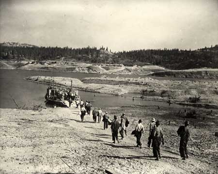
| WPA workers boarding Gerome Ferry to take them to Camp Gerome, on the far side of the river. Note the tree stumps on the land that will be inundated by the reservoir. Photo courtesy of MSCUA, University of Washington (Grand Coulee Dam 5). |
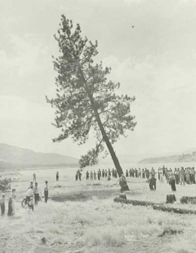
In April 1941, the government declared the clearing work a national defense project, which intensified the push to complete the work. Contractors built the dam faster than anticipated, and the WPA was hard pressed to complete the clearing on time. The last tree was cut July 19, 1941, near Kettle Falls. The work at Kettle Falls then consisted of grubbing and burning and dismantling camp buildings, but the clearing had not been completed when water began flowing over the site. [34]
On June 1, 1942, people gathered to watch the first trickle of water flow down the spillway face of Grand Coulee Dam. The reservoir was full at the downstream end, but it took another six weeks to reach the 1,290-foot level all the way up the reservoir. [35] The clearing project was done. The still waters of the Columbia River Reservoir - soon to be known as Lake Roosevelt - now lay where the Columbia River had once flowed. The home sites of some three thousand people lay beneath the water.
|
| Bureau of Reclamation Supervising Engineer Frank A. Banks and State WPA Administrator Carl W. Smith felling the symbolic "last tree" in the reservoir area, on the site of old Kettle Falls, July 19, 1941. Photo courtesy of U.S. Bureau of Reclamation, Grand Coulee (USBR Archives 189). |
Grand Coulee Dam from World War II to Present
Total construction costs of reservoir (Lake Roosevelt)
for:
-- Hall, Final Construction Report, 1952 |
Grand Coulee Dam was completed just in time to help with the war effort. During World War II, power from the dam went to defense programs such as aluminum production for airplanes and the Hanford project developing plutonium for atomic bombs. The rapid industrial expansion and population growth that the Pacific Northwest experienced due to the war guaranteed a market for the electricity that some had predicted would become an embarrassing surplus. [36]
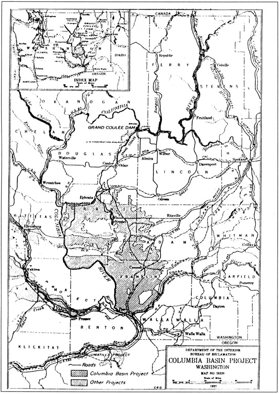
While Grand Coulee Dam was under construction, plans moved ahead for the larger Columbia Basin Irrigation Project, the largest single reclamation project ever undertaken in the country. In 1933, the state formed the Columbia Basin Commission to promote the general plan for the dam, storage reservoir, pumping plant, canals, and other elements of the irrigation plan. The upper Grand Coulee's "equalizing reservoir" was created to store water pumped some three hundred feet up from the lake behind Grand Coulee Dam. This water was then available to be distributed for irrigation. This thirty-mile-long reservoir, named Banks Lake in 1958 in memory of Reclamation engineer Frank Banks, was first filled with water in 1951. The irrigation network was never fully completed to the extent envisioned in the 1930s, however. Today, the project irrigates over 556,000 acres covering an area of about 60 by 120 miles (about half the amount possible for the entire project). [38]
One more round of large-scale construction occurred at Grand Coulee Dam later in the twentieth century. Construction of the third powerhouse, authorized by Congress in 1966, required the removal of a section of the original dam's east end. The finished building could hold twelve generators; the first six went on line between 1975 and 1980. The new power plant allowed Reclamation to double its irrigation flow from Banks Lake. It also allowed Grand Coulee Dam to become a "peaking plant" as well as a day-to-day power producer, coming on and going off during each day depending on the demand for power. Power generated at Grand Coulee Dam is fed into the Pacific Northwest Power Grid maintained by BPA and is sold to Washington, Oregon, Idaho, and parts of Montana and California. In addition, ties to other grids allow power to be sold outside the region. [39]
The construction of Grand Coulee Dam had far-reaching effects in many realms besides power generation and irrigation. The creation in the late 1930s of a reservoir where there had once been a river dramatically affected the lives of many living in the area. The lake also created new recreational opportunities, leading to the establishment of a national recreation area to serve both local residents and visitors.
|
| 1937 map of the Columbia Basin Project showing lands to be irrigated by water pumped from the Upper Columbia River at Grand Coulee Dam into the equalizing reservoir (Banks Lake). (USBR Project History 1933.) |
| <<< Previous | <<< Contents >>> | Next >>> |
laro/adhi/chap2.htm
Last Updated: 22-Apr-2003