|
NATIONAL PARK SERVICE
A Proposed Lewis and Clark National Wilderness Waterway |

|
THE PROPOSAL
CONCLUSIONS
1. The area under study is nationally significant because of the unusual and varied resources which it possesses. Primary among these are: a sizable free-flowing portion of the Nation's longest and one of its most noted rivers; unique scenery; outstanding representation of Upper Cretaceous geology; drainage related to continental glaciation and historical associations with the eras of exploration, the fur trade, Indian and military affairs, and steamboat navigation.
2. These natural and historical resources are not adequately represented in the National Park System today.
3. The area is suitable and feasible for National Park purposes.
4. Inasmuch as there appears to be no present classification which properly encompasses the unique combination of values inherent to this area, the designation "Lewis and Clark National Wilderness Waterway" is suggested for the following reasons:
(a) The Lewis and Clark Expedition, which followed the Missouri River to its headwaters, is the primary element in the history of this area.
(b) The Missouri, our Nation's longest river, was a major artery of westward expansion.
(c) Its river wilderness character is little disturbed by man.
RECOMMENDATIONS
Based on the foregoing conclusions, it is recommended:
1. That the 180-mile section along the Missouri River described in this report be established as the "Lewis and Clark National Wilderness Waterway."
2. That this area be managed in three units as follows:
(a) The Fort Benton-Virgelle Unit to remain essentially in its present ownership but to be zoned or otherwise controlled to keep the river course and its immediate banks relatively undisturbed.
(b) The White Rocks-Badlands Unit to be owned by the Federal Government and administered by the Department of the Interior through the National Park Service.
(c) The Fort Peck Game Range Unit to remain under its present ownership and administration with the desired use of the land and preservation of its natural, landscape assured through cooperative agreements between Federal and State agencies.
3. That the necessary steps be taken and action initiated as soon as possible to achieve the establishment of this area as a unit of the National Park System.
THE AREA AND ITS ADMINISTRATION
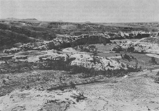
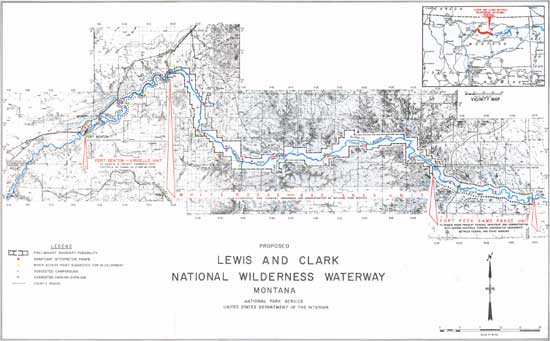
The suggested boundary for this proposed area is shown on the attached map entitled "Proposed Lewis and Clark National Wilderness Waterway." This 180 river mile strip from Fort Benton to Ryan Island averages about two and one-half miles in width, being three-fifths mile at its narrowest point near Fort Benton, and five miles at its widest point near the PN Ferry. It includes approximately 268,000 acres. Preliminary studies disclosed that this size would be adequate to preserve the natural and historic resources involved and provide for desired public and administrative facilities.
The area has been divided into three suggested administrative units which are described separately as follows.
Fort Benton - Virgelle Unit
This unit which begins at Fort Benton and ends just west of Coal Banks Landing near the Virgelle Ferry is 42 miles long, averages one mile in width, and consists of approximately 29,000 acres.
It is suggested that this unit remain essentially in its present ownership and that the preservation of the natural waterway scene as viewed from the river be achieved by zoning or other methods. Compliance with this could be assured by requiring that plans for any new facilities within this area be approved by the Secretary of the Interior prior to construction. This need not interfere with an individual's buying or selling land.
White Rocks - Badlands Unit
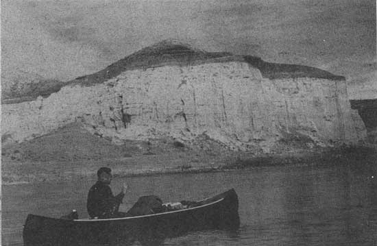
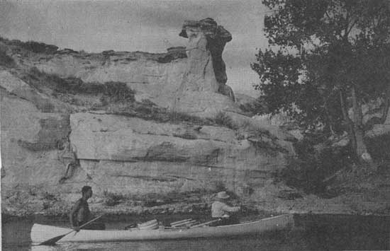
This 99-mile unit begins just west of Coal Banks Landing near Virgelle and ends at the western boundary of the Fort Peck Game Range near Grand Island. The average width is three miles and the area encompasses approximately 186,000 acres which includes about 10,000 acres of the Missouri River itself. It contains the most spectacular and unusual features and excellent waterway wilderness, as well as several significant historic and archeological sites and the minimum degree of man-made disturbances.
This unit is suggested for Federal ownership and administration by the Department of the Interior through the National Park Service. Public hunting would be permitted here only as a means of controlling overpopulations of wildlife and under regulations prescribed by the Secretary of the Interior in coordination with the hunting regulations of the State of Montana Fishing would be an appropriate use and would be regulated in accordance with State laws.
Fort Peck Game Range Unit
Beginning at the western boundary of the Fort Peck-Game Range near Grand Island and extending approximately 39 miles downstream almost to Ryan Island would be the eastern unit of the proposed Lewis and Clark National Wilderness Waterway. This unit includes about 53,000 acres and would average two miles in width.
Most of this acreage is Federally owned and administered under a three-way cooperative agreement between the Corps of Engineers, the Bureau of Land Management, and the Bureau of Sport Fisheries and Wildlife. It is believed preservation of the natural scene as viewed from the river's surface could be achieved here by minor modifications and additions to this cooperative agreement. Therefore, it would seem best to leave this unit under its present ownership and administration. This would apply also to the Kipp State Park portion of the unit.
The present policy on public hunting in this unit and the Fort Benton-Virgelle Unit need not be changed if the proposed Lewis and Clark National Wilderness Waterway becomes a reality.
DEVELOPMENT AND USE
The most intimate and inspiring way to see and enjoy this wilderness waterway is from the surface of the river itself. The Missouri, with its shallow bottom; ever-changing shoals, channel, and sandbars; and its several rapids; offers a wonderful opportunity for boating here in shallow draft vessels such as canoes, john-boats, rubber rafts and kayaks.
Excitement, adventure, and peace of mind await those who may venture into this wilderness waterway by boat, or those who may observe its wonders from trailpoint or canyon rim. Here the past combines with the present to create such an atmosphere of wonder and adventure that the river traveler may expect to come upon the Lewis and Clark party just around each bend in the river.
Camping, too, is an enjoyable part of this boating experience and indeed a necessary one for those penetrating deeply into this canyon wilderness. What more stimulating experience than to pitch camp in the evening after an invigorating day on the Missouri River. What an experience to cook out on a summer's evening when the birds are most active in flight and song; to curl up in a sleeping bag and watch the reflection of a dying campfire play upon the canopy of a cottonwood tree as a gentle breeze stirs the leaves into a drowsy rustling; to hear the soothing sound of the river gliding by, and occasionally the splash of fish breaking the surface, or the distant call of a Canada goose. What is more pleasant than to drop to sleep under a star-filled sky and to be awakened by the song of a Bullock's Oriole flitting about in the cottonwoods like a dart of shining orange and black among the green and gently windblown leaves, or to gaze sleepily at a pair of majestic golden eagles soaring overhead.
|
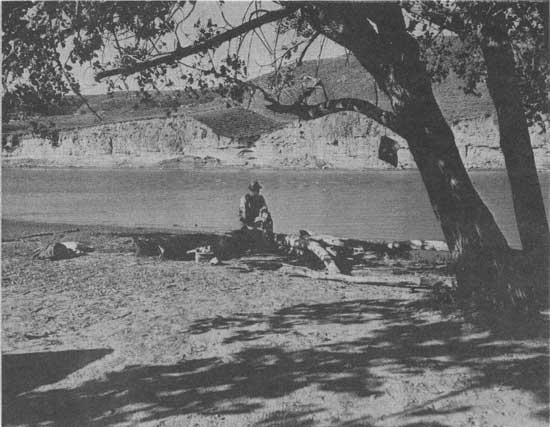
| River flats and shady cottonwoods provide opportunities for primitive camping at the stream's edge. |
|
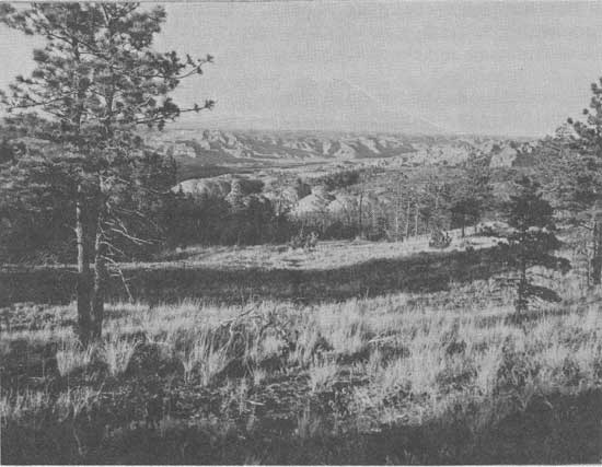
| Open glades on the forested rim offer the motorist scenic views and opportunities for picnicking and camping far above the river wilderness below. |
|
|
"A number of the small martin (cliff swallow) which build their nests
with clay in a globular form attached to the wall (of cliffs)...were seen...."
-- Meriwether Lewis - 1805
|
|
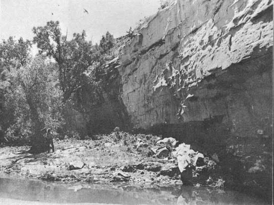
| Eagle Creek beckons the visitor to stay awhile and explore. Lewis and Clark camped near here May 31, 1805. |
This amazing area seems to beckon its guests to linger awhile to enjoy more intimately such wildlife as a startled deer around a sharp turn of a coulee, beaver chiseling industriously on a cottonwood tree, or a colony of cliff swallows darting in and out of their mud houses attached to sheer walls of striking white rock; and to see interesting geological features such as natural bridges, cave-like shelters, and igneous intrusions which can be observed at close range by those willing and eager to hike to them; or to stand at the site of a Lewis and Clark campground. Greater use of recreation opportunities such as these awaits development of this area.
If developed as a National Wilderness Waterway, the wilderness atmosphere of the area should be carefully preserved because this is one of its outstanding assets. The use of small, quiet craft would be more appropriate along certain select portions of the river where the mood of the Lewis and Clark saga pervades the air and would be spoiled by even the softest whine of a small outboard motor. The use of motor boats would be more appropriate in sections such as the Fort Benton-Virgelle and Fort Peck Game Range Units where the natural scene has been modified by man.
Campgrounds would be provided along the river and spaced at appropriate locations to permit visitors to participate in journeys varying from a few hours to a week or longer. Some river campgrounds would be accessible only by boat; others would be accessible by road at points where boats may be launched and removed easily from the water. Also accessible by road would be a few campgrounds located at appropriate spots on the valley rim.
At some of the river access points boat rental operations, supply and equipment facilities, and guide and interpretive services would be provided.
|
|
Douglas fir
|
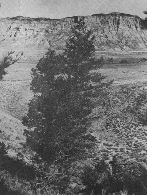
"The country has. . .become desert and barren. . . there is no timber except the thinly scattered pine (Ponderosa) and spruce (juniper and Douglas fir) on the summits of the hills, or along their sides."Lewis and Clark Journals - 1805
"We... came to a handsome river which discharges on the south... We called it Judith's river...The water is clearer than any which we have yet seen; and the low grounds...are wider and more woody than those of the Missouri. Along its banks we observed some box-elder intermixed with cottonwood and willow; the undergrowth consisting of rosebushes, honeysuckles, and a little red—willow."-- Lewis and Clark Journals - 1805
Although the present recreational use of this area is enjoyed mainly by a few local residents, should the area be established as a "Lewis and Clark National Wilderness Waterway" and adequate provisions made for its use, people nationwide would include it on their vacation itineraries.
The varied recreational opportunities in this area would offer much to those interested in sightseeing, boating, fishing, camping, picnicking, hiking, birdwatching, auto touring, photography, hunting, and perhaps horseback riding. Those with interests in history, archeology, geology, botany and wildlife would find experiences here most rewarding.
All of this would be encouraged and made more meaningful by park naturalists and historians who would interpret the rich natural and human history of this area in popular language for the visitor. Conducted float trips, auto caravans, bus tours, nature walks, and campfire programs would enable those interested to have unforgettable experiences in the area. Interpretive markers, self-guiding trails, and wayside exhibits would provide interesting details of the natural and historical scene for the benefit of those exploring on their own.
|
|
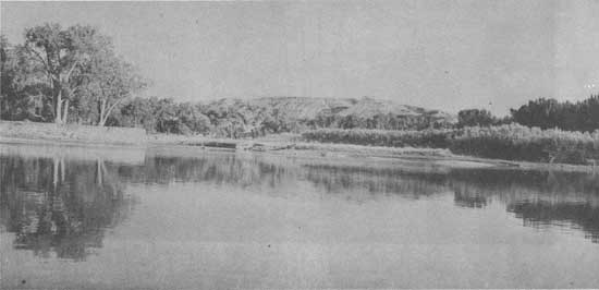
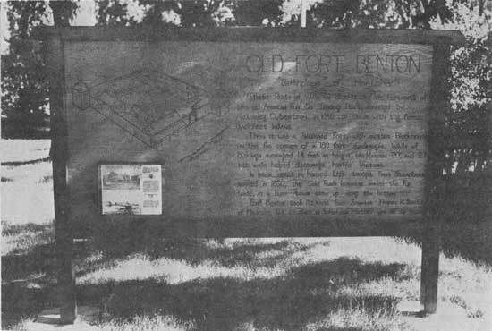
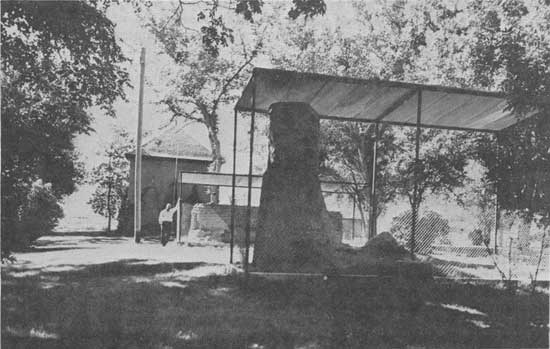
Remains of Fort Benton - 1961
|
Although the best way to see this area is by boat, it need not be the only way. Certain outstanding views from the top of the river bluffs would be made accessible by road. Overlooks and roads would be carefully located so that cars would not be noticeable from the river. A rather extensive trail system would be provided so visitors might experience closer association with the natural and historical values of the area on foot or horseback.
Park personnel would be stationed within the White Rocks-Badlands Unit at strategic locations where the public could be served to the best advantage. One of the better locations for a contact and interpretive station would be at the mouth of the Judith River.
Certain small areas in the Fort Benton-Virgelle Unit would be acquired and administered by the National Park Service to preserve historic features, such as Lewis and Clark campsites, and to provide camp and water access facilities. Cooperative planning with the other Federal agencies administering the Fort Peck Game Range Unit would insure good continuity of visitor facilities. The Kipp State Park under its present administration ties in quite nicely with the proposed overall scheme for the Lewis and Clark National Wilderness Waterway.
|
| Boating on this wilderness waterway with only the sound of one's paddle breaking the stillness brings man closer to God and himself. |
Reintroduction of some of the animals originally native would be an important part of the plan to enable visitors to experience the impressions of Lewis and Clark, in part at least, on their voyage of discovery. Bighorn sheep and elk have been reintroduced in the Fort Peck Game Range. The return of buffalo is planned in the future. Movement of these animals into the White Rocks-Badlands Unit would probably take place naturally; if not, it could be achieved artificially by close cooperation between the various administering agencies.
Park headquarters would be located at Fort Benton where year-round accessibility by highway and railroad are excellent. Most visitors would make their first contact at a visitor center, preferably near the site of the historic Fort itself. The visitor center would consist of administrative offices and a museum. This would be the interpretive and information center of the park. Here would be told in exhibit form the varied stories of this section of the Missouri River--its geology, its biology, its history, above all, its Lewis and Clark story--and the significance. of the area to the Nation as a whole.
Historic Fort Benton would not be overlooked. Its site should be included within the boundaries of the Waterway, and the Fort itself should receive its proper share of interpretation and perhaps partial restoration. Also, restoration of a portion of the Fort Benton waterfront to its appearance during the steamboat era should be considered.
|
| Proposed Lewis and Clark National Wilderness Waterway, Montana. (click on image for a PDF version) |
| <<< Previous | <<< Contents>>> |
lewisandclark2/sec3.htm
Last Updated: 14-Jan-2008